hudsonvalley21
-
Posts
4,228 -
Joined
-
Last visited
Content Type
Profiles
Blogs
Forums
American Weather
Media Demo
Store
Gallery
Everything posted by hudsonvalley21
-
One of the classic lines. Oh by the way, how much for philly
-
Agree on the active pattern coming up. As others sent their condolences for your loss, I also send them to you and your family.
-
From 18 up to 21 in an hour here.
-
Pretty impressive. 18/12 here currently.
-
Hang in there buddy, if you need anything let me know.
-
3.3 here in New Windsor
-

-
The same here. My feeling is that we get maybe and inch tomorrow night up this way.
-
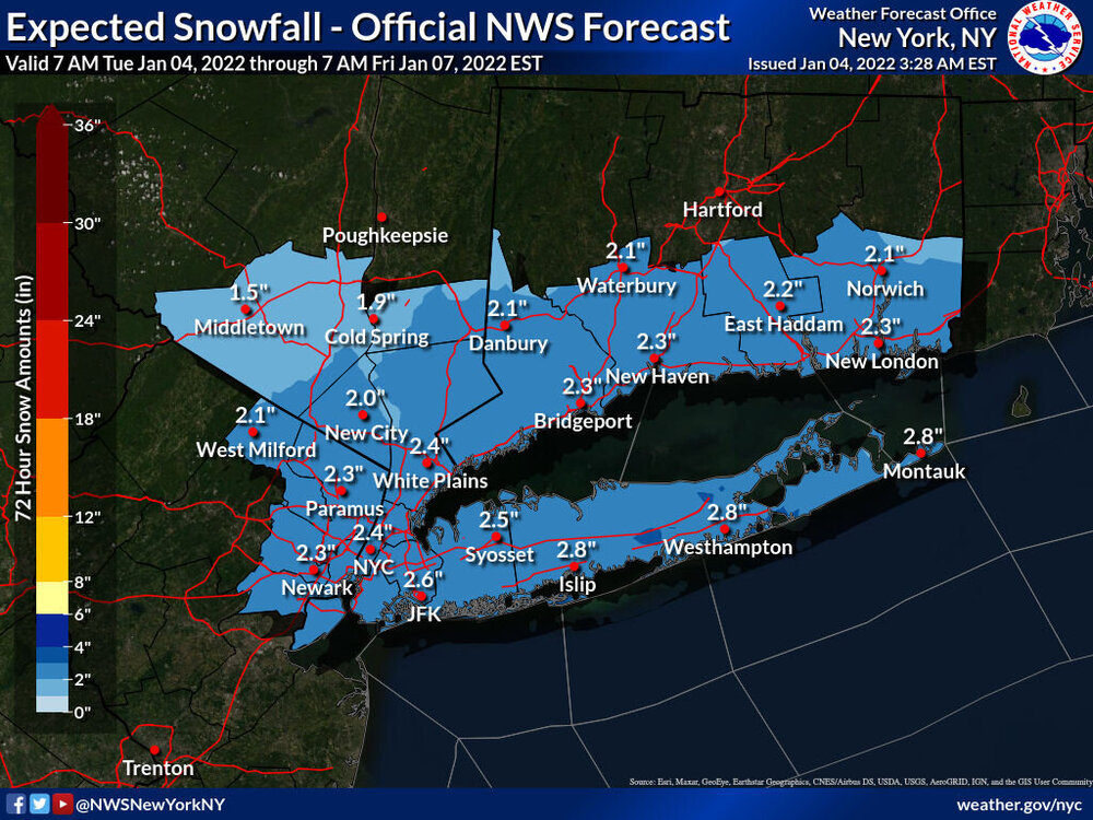
Overnight low of 13. Upton’s snow map as per the overnight.
-
Same here. 13
-
Upton’s current call map from overnight.

-
It’s the computer I swear

-
Could be here today and gone tomorrow.

-
No model consensus
-
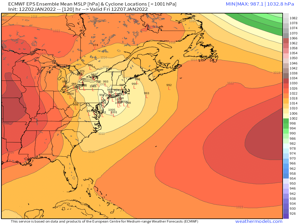
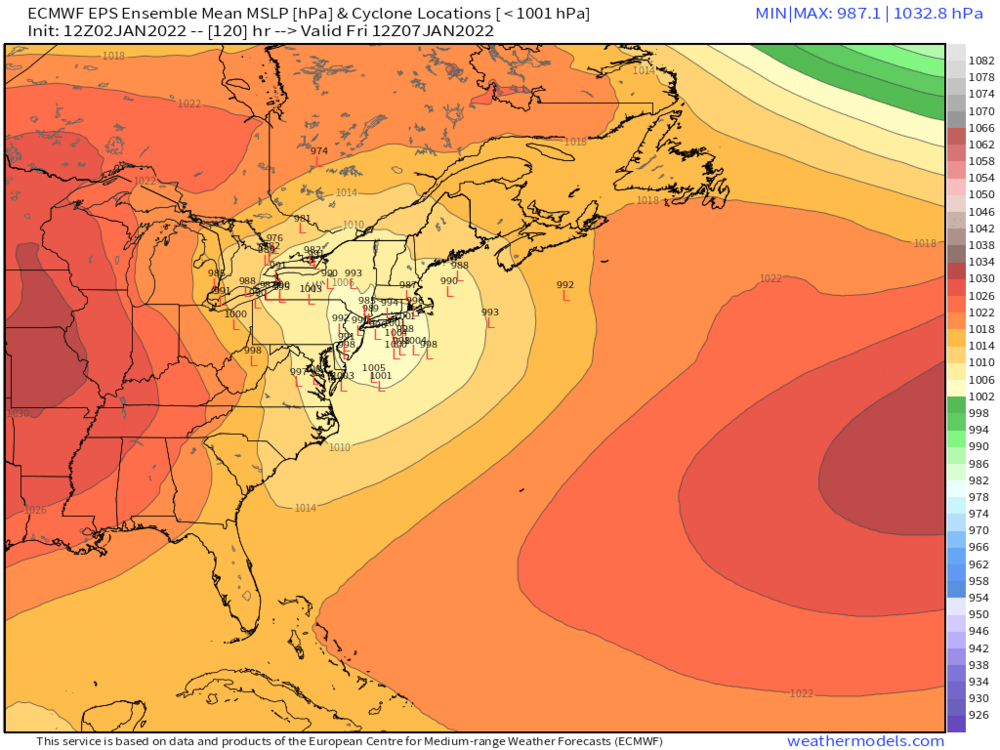
Not sure on the blocking. Hopefully the parent low in western NY transfers over to the costal in time.
-
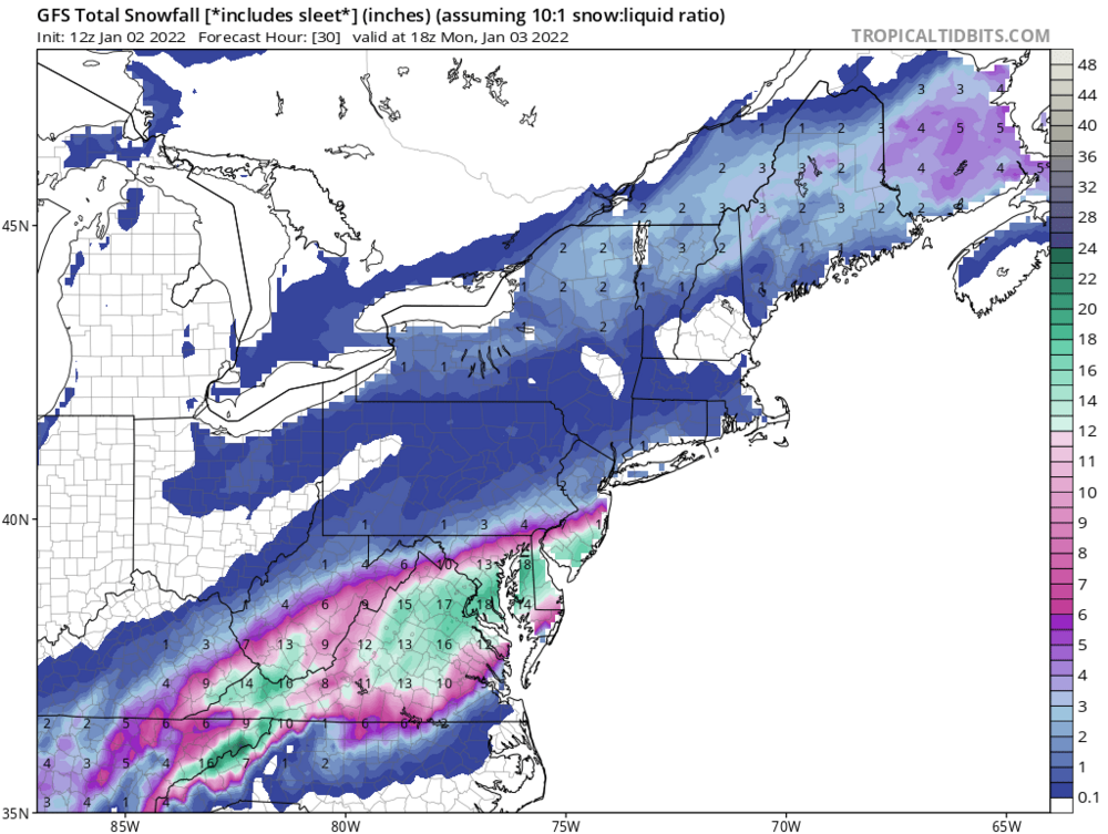
Borrowed this image from the New England Region
-
I knew you would bring us some luck look the snowhole, it’s to our north
-
Happy new year’s. Sorry to hear about the rough week. I say go ahead and start it up. I’m sure the luck of the Irish will shine.
-
January 2022 temperature forecast contest
hudsonvalley21 replied to Roger Smith's topic in Weather Forecasting and Discussion
DCA +0.3 NYC +0.1 BOS +0.0 ORD -2.8 ATL +1.5 IAH +2.1 DEN -0.9 PHX +0.5 SEA -2.4 -
No fog here at my lower elevation. But the damp rotting is, we need a freeze and some snowpack. Happy new year’s to all
-
Same here in obs. Expecting more ZR here.
-
Merry Christmas to one and all. All wet here today temps just above freezing.
-
Upton mentioned the cooler side in their AFD, a section of that is posted further down. I traveled over Storm King mtn. today and there was a good accretion of ice over 1000’. There could be more added up there overnight. NEAR TERM /UNTIL 7 AM SATURDAY MORNING/... With weak cold air damming, temps have fallen into the upper 20s to the S CT coast. With weak flow overnight ahead of warm front, concerns that temps may not be able to warm above freezing (particularly north of I-95) before onset of light rain late tonight. Have expanded Winter Weather Advisory southward to coastal CT zones for increasing potential of a period of light freezing rain late tonight through around daybreak Saturday. Similarly have added W Bergen and S Westchester based on temp trends, and earlier onset of rain. These areas should quickly rise above freezing after daybreak, if not before. Interior zones, remain under the earlier issued Winter Weather Advisory for the most efficient icing, with temps holding in the mid to upper 20s overnight, before rising above freezing early to mid-morning. Otherwise, forecast on track with a warm front associated with the next frontal system moves into the area tonight and brings with it a widespread area of light precipitation. Warm air aloft will prevent any of the precipitation from remaining frozen, however, sub-freezing surface temperatures for northern areas will allow for the likelihood of a period of light freezing rain tonight and into early Christmas morning. Total ice accumulations of a light glaze to a few hundredths of an inch are possible with highest amounts (locally 1/10th of an inch) likely in the northernmost zones. Any freezing rain becomes plain rain by early to mid morning.
-
Don’t be so negative, even a broken clock is right twice a day.