hudsonvalley21
-
Posts
4,248 -
Joined
-
Last visited
Content Type
Profiles
Blogs
Forums
American Weather
Media Demo
Store
Gallery
Everything posted by hudsonvalley21
-
Well now sit back and enjoy a steak.
-
Just has to close off a few hours sooner
-
+1 for the low here.
-
It’s time and money to be prepared, but you can’t get caught with your pants down.
-
Could go down to nowcast time and looking at the HRRR.
-
That would be one bumpy flight if it does get in the air on time.
-
Absolutely
-
Emotions definitely. A lot of folks got sucked in by the the euro days ago. This has been a thread the needle type event and you might not have model consensus until 12z Friday. Placement of 50-100 miles and a sharp precipitation cutoff is huge here for winners and losers. Still anyones game.
-
Maybe some dropsondes readings are in this run?
-

-
Many moving parts,many outcomes. Maybe by 12z Thursday or 00z Friday when all the parts have been on the playing field. It’s Still a coin toss.
-

-
Hopefully the 12z runs tomorrow will have a good consensus either good or bad.
-
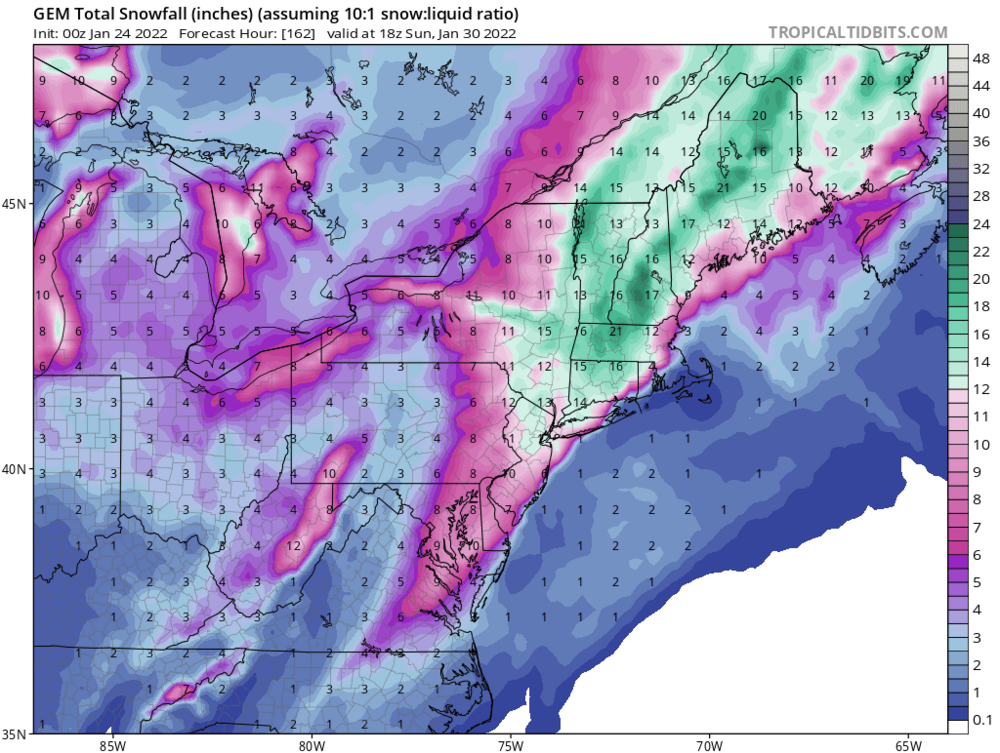
It was nice looking at the porn snow maps the last couple of days. I would wait till the 12z runs tomorrow. Too hopefully get a good idea with a few runs with the sampling’s inputted.
-

-
Almost there. Maybe 00z -12z on Thursday should do it. 50-100 mile shift could make a difference. Also there is a possibility of it slowing or stalling out. Just a few more runs.
-

-
Absolutely, I would start getting comfortable after the 12z runs Thursday. For now it’s sit back and see what evolves till then.
-

-
Light snow here, coating on all surfaces. 27/23
-
Model mayhem this season. Flip flopping more than a fish out of water.

-