hudsonvalley21
-
Posts
4,248 -
Joined
-
Last visited
Content Type
Profiles
Blogs
Forums
American Weather
Media Demo
Store
Gallery
Everything posted by hudsonvalley21
-
I plugged mine in last night before it started. It’s definitely doing it’s job for the gutters and leaders. Going to go down into the teens tonight, going to keep them plugged in.
-
2.0 of pure sleet.
-
February 24/25 Potential Winter Storm
hudsonvalley21 replied to mikem81's topic in New York City Metro
Amen to that. Just got done. 2.0 of pure sleet. Great move to put down some calcium chloride last night before it started. -
Holding at 27/10 up this way KSWF OBS has been basically unchanged for the last 4 hours. Only the dew point has slowly risen from 7 to 10.
-
February 24/25 Potential Winter Storm
hudsonvalley21 replied to mikem81's topic in New York City Metro
27/12 up this way. Been holding there for the last few hours. Temps might drop off a few at the surface up this way too at the onset especially if the precipitation would be moderate to heavy at times. -
February 24/25 Potential Winter Storm
hudsonvalley21 replied to mikem81's topic in New York City Metro
27/12 here currently. -
February 24/25 Potential Winter Storm
hudsonvalley21 replied to mikem81's topic in New York City Metro
Agree. Folks were hoping for a secondary to form around Long Island sooner for that to take over. Looks like that won’t happen. -
February 24/25 Potential Winter Storm
hudsonvalley21 replied to mikem81's topic in New York City Metro
Thanks -
February 24/25 Potential Winter Storm
hudsonvalley21 replied to mikem81's topic in New York City Metro
Can you do a sounding for KSWF or KPOU. Thanks -
February 24/25 Potential Winter Storm
hudsonvalley21 replied to mikem81's topic in New York City Metro
Currently 25 here. -
February 24/25 Potential Winter Storm
hudsonvalley21 replied to mikem81's topic in New York City Metro
At this point I wouldn’t ignore anything. Who knows how much the 800mb push will make it northward and what the surface temps will be. I believe most models are showing a sharp cutoff with frozen type precipitation and just might come down to looking at current observations during the event itself. -
February 24/25 Potential Winter Storm
hudsonvalley21 replied to mikem81's topic in New York City Metro
Ok thanks -
February 24/25 Potential Winter Storm
hudsonvalley21 replied to mikem81's topic in New York City Metro
00z NAM is running now. 18z 12k run had basically 8” for your and my area -
February 24/25 Potential Winter Storm
hudsonvalley21 replied to mikem81's topic in New York City Metro
My point and click here basically held serve with 3-7” and 0.1-0.2 ice accretion along with an overnight low of 26. -
February 24/25 Potential Winter Storm
hudsonvalley21 replied to mikem81's topic in New York City Metro
Still time for slight shifts one way or another. A 20 mile shift in either direction will affect many with that sharp cutoff. 18z runs tomorrow could have better ideas with the surface and mid level temps factored in with their placements and readings. -
66 the high here, currently 52. edit, now down to 36. So far down 30 degrees in 7 hours.
-
I’m leaning on the first. The other events were WWA’s
-
I don’t think we’ll have a real handle on this event even up to nowcast time. Also a definite possibility of a sharp cutoff area wiggling thru our region plus a mixed bag of precipitation types. A real toss of the dice IMHO.
-
Same here, looking at the current radar, the squall out by KBGM has another developing area of precipitation just in front of it
-
February 24/25 Potential Winter Storm
hudsonvalley21 replied to mikem81's topic in New York City Metro
Snow porn, sorry for the useless post
-
I see your clown and raise you another one.
-
Cloudy and 59 currently.
-
Totally agree, hoping for a way overdone map.
-
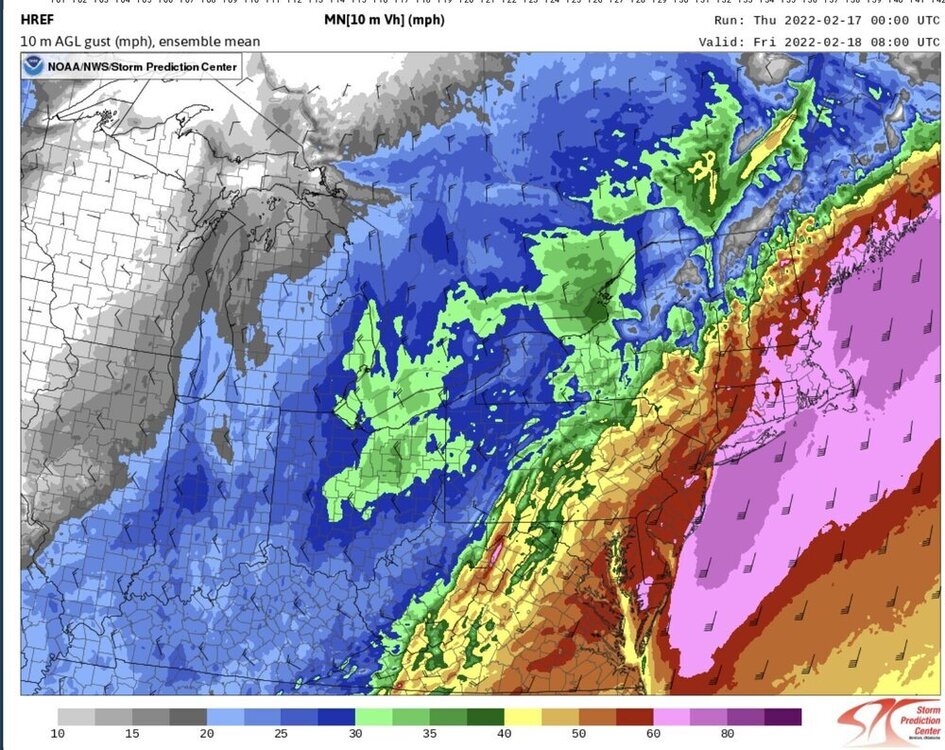
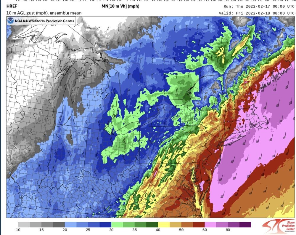
For the overnight hours coming up. upton’s AFD SHORT TERM /6 PM THIS EVENING THROUGH FRIDAY NIGHT/... Sheared shortwave energy races into the eastern Great Lakes tonight, ahead of northern stream shortwave pivoting through the Upper Great Lakes. In response, gradually deepening low pressure/s track from the Ohio River valley this evening up through Western NY tonight, with trailing strong cold front approaching the region, bringing a period of strong to damaging wind gusts and moderate to heavy rain tonight into Friday morning. Ahead of the cold front, models are in good agreement with a strong llj (70-80kt@950mb) developing across eastern coastal areas late tonight into early Friday morning. As is typical for this time of year with water temps in the lower 40s, the challenge is how much of the llj will be able to mix down in a strongly inverted low-level environment. GFS/NAM have remained fairly consistent over the last 48 hrs, with GFS indicating a typically slightly deeper mixed layer, with potential for 50 kt gusts across LI/SE CT, while NAM more strongly inverted indicating gust potential of 40 kt. NBM has trended slightly upward with gust magnitude from 24 hrs ago, with 4.0 indicating 45-50kt gust potential for LI and SE CT, while version 4.1 continuing to showing a 45-55 kt potential for LI/CT. HRRR 10m wind gust potential, which has show to be skillful (albeit a little high) indicating potential for 55-60kt gusts for LI and SE CT as well. SPC HREF indicating high potential for 30kt sustained winds across LI/SE CT as well (not common), supporting the strong to damaging wind gust potential. Based on the model consistency and trends over the last few days, confidence is high in a strong wind (wind advisory) event tonight across the entire area, including NYC (45-55mph gusts), with moderate to high confidence in high winds gusts (55-65mph) for LI and SE CT under the core of the 75-80 kt llj. The timing for peak strong to high wind gusts continues to center around 6-12z Fri. Despite the strong inversion, based on the slight upward trend on NBM 4.0 wind gust guidance towards the stronger NBM 4.1 guidance, the strong signal from CAM guidance, and the anomalous strength of the llj, will upgrade to a high wind warning for all of LI and SE CT. Elsewhere will issue a wind advisory for strong wind gust potential ahead of and immediately behind the cold front, with highest threat along the coast and higher elevations. In terms of heavy rain potential, deep layered lift of a +3-4 STD PWAT gulf moisture plume, and weak elevated instability, will present potential for a 3-6 hr window of moderate to heavy rain tonight. The limiting factor for heavy rainfall amounts will be quick movement of the cold front through the area, racing ahead of shortwave forcing. Medium range ensemble spread generally from 1/2 to 1 inches of rainfall for city/coast, with 1 to 1 1/4 across interior (particularly S CT). SPC HREF indicating a similar distribution, with signal for enhancement along the north shore of LI, interior S CT, and hill terrain. These areas of enhancement are consistent with SBU research on standing gravity wave perturbation precip enhancement in southerly flow events. Steadier rainfall develops from west to east this evening through midnight, with narrow bands of heavy rain indicated by CAMs late tonight with llj and along/ahead of cold front. Rain will quickly come to and end early Friday morning from west to east with cold frontal passage. A few wet snowflakes possible across far NW hills before ending, with no accum. The cold front pushes through Fri AM, with winds shifting to W/NW. Potential for wind advisory gusts of 40-50mph Friday morning areawide with wind shift as lapse rates rapidly steepen/deepen. Gusts should settle into the 30 to 35 mph range for the afternoon. It will be drying out with sunshine for the afternoon, and temps dropping through the day (50s AM to 30s PM) with modified polar airmass advecting in. High pressure noses in Friday Night, with potential for a window of radiational cooling well down into into the teens across pine barrens and interior, 20s elsewhere. High clouds and return flow begin to increase towards Sat morning, with rising temps likely along the coast, ahead of Ontario clipper s