hudsonvalley21
-
Posts
4,248 -
Joined
-
Last visited
Content Type
Profiles
Blogs
Forums
American Weather
Media Demo
Store
Gallery
Everything posted by hudsonvalley21
-
Sun just starting to come thru here. 0.14” here so far, temp currently 57.
-
May 2022 temperature forecast contest
hudsonvalley21 replied to Roger Smith's topic in Weather Forecasting and Discussion
DCA +1.1 NYC +1.1 BOS +1.1 ORD -1.1 ATL +1.7 IAH +1.4 DEN +0.2 PHX +0.6 SEA -0.2 -
All rain here at an elevation of 125’. Temp. 38 rainy week coming up
-
As you know, wore many hats in rockland. Chief in Valley cottage, held many positions in the county along with being the voice ( dispatcher) at 44 control. Well respected.
-
Barry Furey I remember when going thru fire training in Rockland county back in the 70’s. Great guy.
-
April 2022 temperature forecast contest
hudsonvalley21 replied to Roger Smith's topic in Weather Forecasting and Discussion
DCA +2.7 NYC +2.1 BOS +1.9 ORD +1.6 ATL +2.5 IAH +3.0 DEN +2.2 PHX +0.7 SEA -0.1 -
Special Weather Statement National Weather Service New York NY 712 PM EDT Sat Mar 19 2022 NYZ067-200015- Orange NY- 712 PM EDT Sat Mar 19 2022 ...A strong thunderstorm will impact portions of Orange County through 815 PM EDT... At 711 PM EDT, Doppler radar was tracking a strong thunderstorm over Unionville, or 9 miles east of Port Jervis, moving northeast at 45 mph. HAZARD...Winds in excess of 40 mph and half inch hail. SOURCE...Radar indicated. IMPACT...Gusty winds could knock down tree limbs and blow around unsecured objects. Minor damage to outdoor objects is possible. Locations impacted include... Middletown, Port Jervis, Walden, Warwick, Goshen, Howells, Gardnertown, Chester, Montgomery, Florida, Cuddebackville, Otisville, Huguenot, Unionville and Scotchtown.
-
3.6” here.
-
Could be the northwest winds drying it out. Here the wind is picking up from the northwest and blowing the accumulated snow around. No snowfall yet from the approaching line but I assume it will be soon.
-
It will be interesting to see what the approaching line will give us soon.
-
I’m estimating around 3” here.
-
Radar showing precipitation breaking down in southeast Pa. this could be winding down in a couple of hours.
-
Going to be an interesting day to say the least. Tough day for you to measure the snowboards with the forecasted winds.
-
All snow now. 32/32
-
All snow here now. 32 degrees
-
Ice pellets with snow mixing in 35 degrees
-
Looks like Upton is riding the NAM. Area Forecast Discussion National Weather Service New York NY 420 PM EST Fri Mar 11 2022 .SHORT TERM /6 AM SATURDAY MORNING THROUGH SATURDAY NIGHT/... Coupled jet structure indicated by the models supports rapidly deepening low pres tracking thru the region on Sat. With the 12Z NAM and GFS sfc low tracks nearly identical, went close to the 12Z NAM for the bulk of the storm. Conceptual model for how the sys evolves is rain, changing to a mix of rain, sleet, and snow, then to all snow from nw to se before ending late Sat aftn/eve. Strengthening nwly winds as the low deepens during the day, with the gusty winds and strong caa lasting thru Sat ngt. At least some refreezing on surfaces by aftn into the eve. One of the main challenges is how fast the pcpn changes over. With an arctic airmass flowing into the region, the transition is expected to be fairly quick. The exact track will determine the speed with which the caa begins. Any change in the timing of the transition will impact snowfall amounts. Based on the progged track and timing of the 12Z suite of models, snowfall amounts have been increased across the area. Orange county has been upgraded to a wrng, and an advy was issued sewd to NYC and swrn CT. Even in areas that do not average 3 inches of snow, the added hazards of refreezing and high winds warranted the advy. Elsewhere, a winds advy was issued until midnight. The snow, where amounts are expected to be lesser, and refreezing hazards, have been included in the wind advy. At least a coating is expected in these areas attm. A wind advy may need to be issued for after 00Z for wrn portions of the area when the winter wx advisories end. Those spots most susceptible to the need for a wind advy are east of the Hudson River. Wind chills fall into the single digits Sat ngt across the entire area.
-
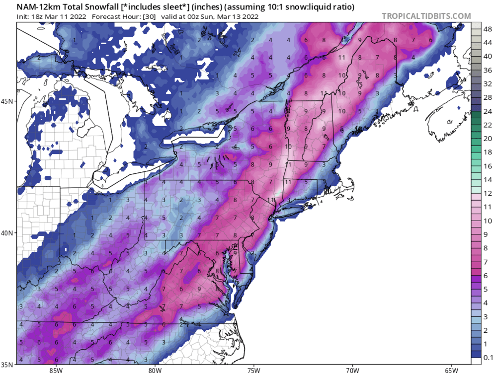
I think this is the Kuchera, could be wrong tho.
-
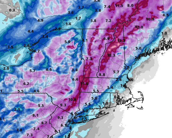
18z NAM up-ticked from the 12z run
-
18z NAM up-ticked the snow amounts from the 12z runs.

-
Well they went with the colder 12z runs. Now with wind gusts up to 40 in the point n click forecast. WINTER STORM WARNING IN EFFECT FROM 6 AM TO 7 PM EST SATURDAY... * WHAT...Heavy snow expected. Total snow accumulations of 4 to 7 inches. Winds gusting as high as 45 mph. * WHERE...Orange County. * WHEN...From 6 AM to 7 PM EST Saturday. * IMPACTS...Plan on slippery road conditions.
-
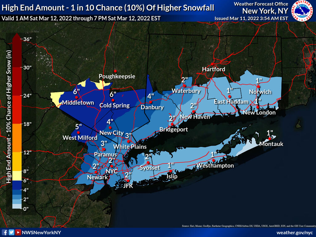
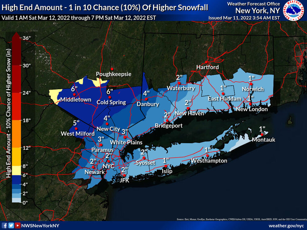
Me neither, and just 1 inch above warning criteria for snowfall. maybe they are going with the high end maps from this morning. They haven’t updated those maps as of yet.
-
They might, my thought is they keep the warning up and tomorrow morning they might scale it back if the short range models back off after looking at the 00z runs.