hudsonvalley21
-
Posts
4,248 -
Joined
-
Last visited
Content Type
Profiles
Blogs
Forums
American Weather
Media Demo
Store
Gallery
Everything posted by hudsonvalley21
-
seen on the news before a satellite caught the underwater eruption. Pretty cool.
-
We had one last night, around 12:45 am. Then not related to that, a power outage at 5am. Power was out for around 2 1/2 hours. House cooled real fast with the temp at +5. Thank god for the manual override switch on my gas fireplace. Currently at +3 with a forecast low of -2.
-
I’m sure they are busy preparing on what watches and warnings will be put up. The wind potential is no joke.
-
Does it show the costal becoming the main low?
-
Agree, will definitely have an impact on the Hudson River bridges with the southeasterly direction. The River valley will act like a wind tunnel.
-
It looks like Upton is going with a snow and heavy at times inland changing to a mixed bag where Mt.Holly is going with a mixed bag forecast in your area without the thump at the onset.
-
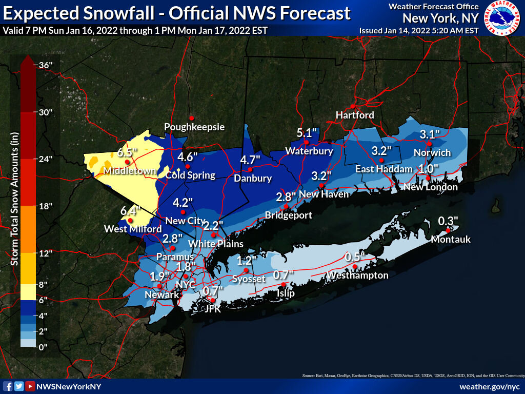
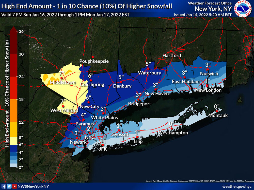
That’s the expected map below is the high end. Not much different.
-
Upton’s first call snow map.

-
Or call the GFS the Queen and let the king keep his crown for an event or two more before yanking it.
-
Over here along the Hudson River, with the s/e wind the CAD will scour out rather quickly due to the n/s orientation of the River. When you get further up by Kingston the CAD hols on longer as the same in areas to the north and west from the Shawangunks blocking.
-
National Weather Service New York NY 346 PM EST Thu Jan 13 2022 CTZ005>008-NYZ067-068-070-141030- /O.NEW.KOKX.WC.Y.0001.220115T0500Z-220115T1500Z/ Northern Fairfield-Northern New Haven-Northern Middlesex- Northern New London-Orange-Putnam-Northern Westchester- 346 PM EST Thu Jan 13 2022 ...WIND CHILL ADVISORY IN EFFECT FROM MIDNIGHT FRIDAY NIGHT TO 10 AM EST SATURDAY... * WHAT...Very cold wind chills expected. Wind chills from 15 below zero to as low as 20 below zero. * WHERE...Portions of southern Connecticut and southeast New York. * WHEN...From midnight Friday night to 10 AM EST Saturday. * IMPACTS...The cold wind chills could cause frostbite on exposed skin in as little as 30 minutes.
-

-
We might not know till Saturdays 00z or 12 z runs. More time for sampling when all pieces are on the playing field.
-
That could definitely be an issue with a few inches of snowpaste on limbs and power lines
-
Futurecast mode
-
I could be wrong, I think he says if it goes negative tilt around the Mississippi, it will turn north too soon and hug the coast or go inland.
-
The wheel is spinning. Where it stops, who knows.
-
One of the classic lines. Oh by the way, how much for philly
-
Agree on the active pattern coming up. As others sent their condolences for your loss, I also send them to you and your family.
-
From 18 up to 21 in an hour here.
-
Pretty impressive. 18/12 here currently.
-
Hang in there buddy, if you need anything let me know.