hudsonvalley21
-
Posts
4,276 -
Joined
-
Last visited
Content Type
Profiles
Blogs
Forums
American Weather
Media Demo
Store
Gallery
Everything posted by hudsonvalley21
-
True, with the lack of moisture, the mosquito activity has dried up too.
-
DCA _ NYC _ BOS __ ORD _ ATL _ IAH __ DEN _ PHX _ SEA +2.6 +2.7 +2.7 +2.9 +2.3 +1.8 +1.9 +1.3 +0.4
-
Good point, we’ve had a frost advisory and a freeze warning last week. To the best of my knowledge, once you have a freeze warning, there were no additional advisories issued. The freeze warning basically states that the growing season has ended.
-
I wii fire mine up later today to give it a test.
-
48 here and miserable compared to yesterday. Light rain currently.
-
My goal each year is to make it to Halloween. Maybe I’ve done that a few times. It looks like next week I might cave with highs in the mid 50’s and lows in the mid 30’s for a few days.
-
Cool morning here, overnight low was 40.
-
October 2024 temperature forecast contest
hudsonvalley21 replied to Roger Smith's topic in Weather Forecasting and Discussion
DCA: + 1.8 NYC: + 1.9 BOS: +1.8 ORD: + 1.3 ATL: + 1.4 IAH: + 1.8 DEN: + 2.2 PHX: + 2.3 SEA: + 0.7 -
If you use this method you have to believe
-
DCA: +2.5NYC: +2.7BOS: +2.6ORD: +2.7ATL: +2.1IAH: +2.2DEN: +2.7PHX: +2.1SEA: +0.6
-
Good heads up on the PRE coming up thru NJ. Left Rehoboth beach late this morning instead of leaving late this afternoon. Driving conditions appear to be a slow according to current radar.
-
Nice, and more in the forecast tomorrow. 1.49” is the total for me today. Going down to Delaware next week. Maybe I’ll see some nice surf Thursday as some models are showing currently. Subject to change of course.
-
If it was only January
- 1,764 replies
-
- 1
-

-
- hurricanes
- tropics
- (and 5 more)
-
Didn’t have much for the week till today. 1.36 in the bucket today after this current cell moved thru. Good CTG strikes in the area. Well needed rain.
-

-
The waffling has been constant the last week or so. Hard to plan on when to water the garden by the forecast that has busted on the dry side. The garden type scattered showers have been near misses here. went to the Fair oaks drive-in last month had a cool dry nite luckily.
-
August 2024 temperature forecast contest
hudsonvalley21 replied to Roger Smith's topic in Weather Forecasting and Discussion
DCA: +3.2NYC: +2.9BOS: +2.5ORD: +2.4ATL: +2.8IAH: +3.1DEN: +3.0PHX: +2.1SEA: +1.4 -
Had 1.49” for the total. A nice refreshing drink for the lawn and flowers. No severe weather thankfully. Hopefully all is well with you. All is good here.
-
Impressive, my high was 90 here.
-
Not IMBY according to Upton Tonight Partly cloudy, with a low around 69. Calm wind. Monday Sunny, with a high near 92. Calm wind. Monday Night Partly cloudy, with a low around 72. Calm wind. Tuesday A 40 percent chance of showers and thunderstorms, mainly after 2pm. Patchy fog before 11am. Otherwise, partly sunny, with a high near 93. Heat index values as high as 102. Calm wind becoming south 5 to 7 mph in the afternoon. Tuesday Night A 30 percent chance of showers and thunderstorms. Mostly cloudy, with a low around 74. South wind around 6 mph becoming calm in the evening. Wednesday A chance of showers, then showers likely and possibly a thunderstorm after 2pm. Mostly cloudy, with a high near 90. Chance of precipitation is 60%. New rainfall amounts between a tenth and quarter of an inch, except higher amounts possible in thunderstorms. Wednesday Night Showers likely and possibly a thunderstorm. Mostly cloudy, with a low around 73. Chance of precipitation is 60%.
-
Nice AFD from Upton, X Area Forecast Discussion National Weather Service New York NY 1125 AM EDT Sat Jul 6 2024 .SYNOPSIS... A trough of low pressure lingers over the area through Saturday afternoon as a cold front approaches. The front then stalls and lingers into Sunday before dissipating as high pressure builds from the west. Another frontal system approaches early next week with its associated cold front moving in towards midweek. This frontal boundary could very well linger nearby from mid to late week. && .NEAR TERM /THROUGH TONIGHT/... ***Key Points*** 1.) Heat Advisories remains in effect across NE NJ, NYC, N Nassau Co, Lower Hudson Valley and Fairfield Co. Heat index values could reach up to 105F for southern portions of NE NJ. All other areas under the Heat Advisory could see heat indices peak between 98-100F. 2.) Isolated to scattered showers and thunderstorms re-develop this afternoon & evening. Chances look better for western locations. A prefrontal surface trough is expected to linger just west of the Hudson River this afternoon before a weak cold front approaches from the west and slowly passes and stalls tonight. This occurs in tandem with an upper-level trough to our north which weakens through tonight. First round of showers and thunderstorms are moving out east late this morning. CAPEs recuperate this afternoon, especially INVOF NYC metro and areas north and west with partly sunny conditions and a moist boundary layer. SBCAPES of 1500-2500 J/kg anticipated for these areas. With the trough in place and subtle shortwave energy providing some mechanical lift, iso-sct showers and thunderstorms anticipated for approx the western half of the forecast area mid afternoon into early evening. Bulk shear in combination with CAPE is enough for at least some consideration of severe wind gust potential in thunderstorms, mainly NW of NYC where conditions will be slightly more favorable. Freezing/wet-bulb zero heights are rather high, so while hail will be possible given CAPE and shear aloft, chances are it won`t reach severe thresholds. After about 9 or 10pm, most of the shower and thunderstorm activity should be cleared out of the area with a front stalling across the area. Patchy fog may occur with persistent cloud cover across eastern areas, but will mainly depend on where the weak front stalls. Overnight lows will drop into the low/mid-70s. Flash flooding threat remains lows this afternoon into evening. PWATs have lowered to around 1.75" in the area where showers and storms are more likely to occur, and the flow aloft is strong enough to prevent very slow-moving cells. Should training occur, there could be a low threat of flash flooding, but looking at mainly minor urban/poor drainage flooding potential. Dewpoints generally in the mid 70s this afternoon with actual highs in the upper-80s to low-90s in the NYC metro and areas N/W of NYC. The rest of S CT and LI see highs in the mid/low-80s with far eastern areas in the upper-70s for afternoon highs. Heat Advisories remain posted across NE NJ, NYC, N Nassau Co, Lower Hudson Valley and Fairfield Co. Heat index values could reach up to 105F in spots for the urban corridor of NE NJ. All other areas under the Heat Advisory could see heat indices peak between 95-100F. Some guidance appears to veer winds from S to SW late in the day, advecting in drier low-level air. Should this occur earlier than expected, heat advisory criteria may be more on the marginal side for some areas outside of NE NJ, but for now, expecting a later arrival of this drier air.
-
0.38 around 6pm yesterday and 1.15” this morning for a total of 1.53” in 12 hours. Great for the garden. Had a dew pt. of 77 last night. Definitely Florida like conditions.
-
July 2024 temperature forecast contest
hudsonvalley21 replied to Roger Smith's topic in Weather Forecasting and Discussion
DCA: +4.3NYC: +2.9BOS: +2.9ORD: +2.4ATL: +2.6IAH: +2.2DEN: +2.5PHX: +2.3SEA: +0.7 -
Glad to hear no damage, hopefully you get the power back on soon. 0.51” in the bucket. My Daughter is by Craigsville rd and luckily did not loose power.
-
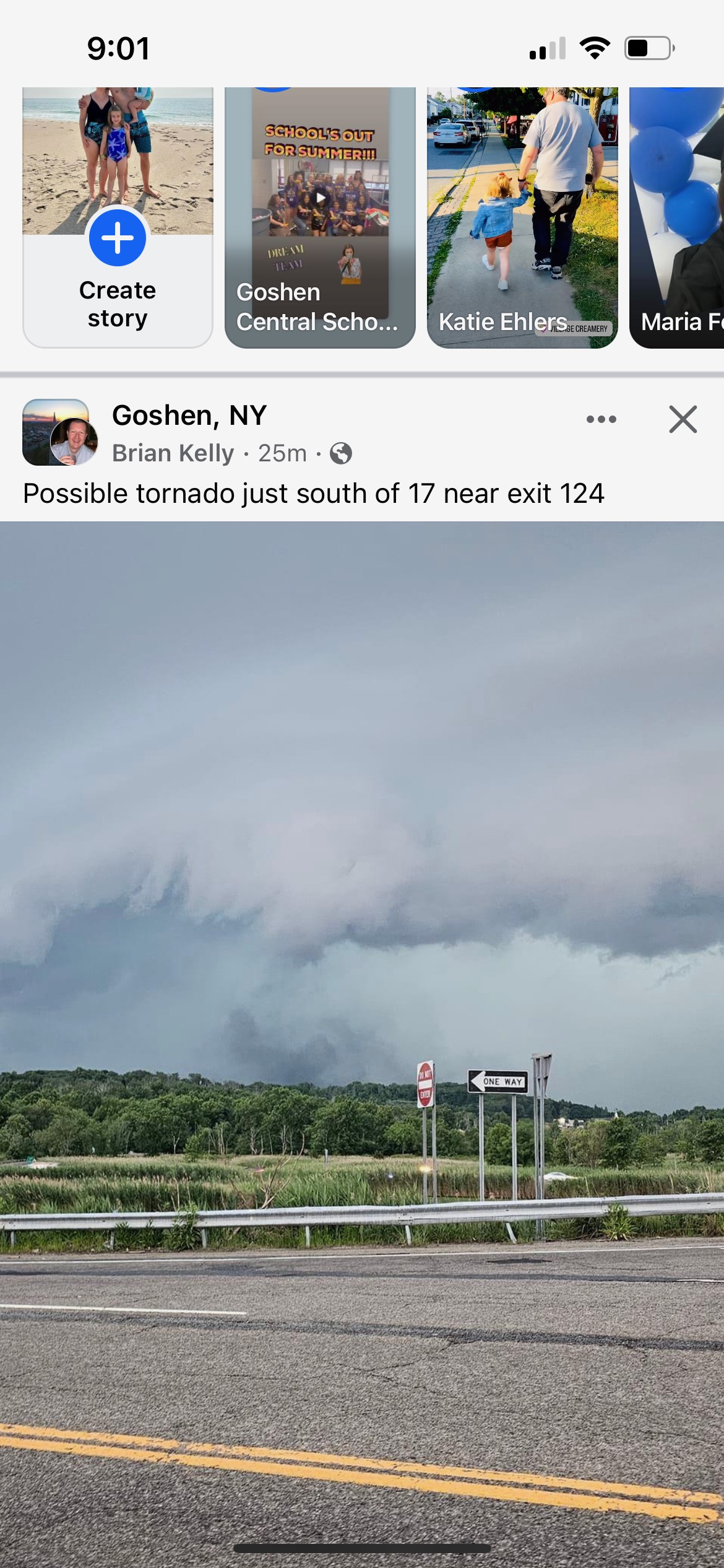
A photo from Facebook near Lego Land in Orange County