hudsonvalley21
-
Posts
4,265 -
Joined
-
Last visited
Content Type
Profiles
Blogs
Forums
American Weather
Media Demo
Store
Gallery
Everything posted by hudsonvalley21
-
Hi Rodger, I added my seasonal maxes. Thanks for all you do!
-
The Tent Caterpillar showing this year is the largest I’ve seen in the last few years. See a bunch of crabapple trees stripped throughout the area. The HRRR is showing a few showers moving thru later this afternoon and early evening, hopefully it will wash some of that poop away.
-
Thank goodness I only got 0.04” in the bucket. Saves me from shoveling the driveway
-
0.04” here.
-
0.86 here.
-
DCA: +0.8 101NYC: +1.2 101BOS: +1.1 99ORD: +0.3. 95ATL: +1.6 98IAH: +2.2. 103DEN: +2.1 100PHX: +1.4 119SEA: +1.5 98
-
Orange County NY Fire Calls Mutual Aid: Monroe Fire - UTV Warwick Fire - UTV Chester Fire - UTV Tuxedo Fire - UTV Florida Fire - UTV (Unable to Crew) South Blooming Grove Fire - UTV Pine Island Fire - UTV Woodbury Fire - UTV Goshen Fire - UTV (Unable to Crew) Cronomer Valley Fire - UTV New Hampton Fire - UTV (Unable to Crew) Salisbury Mills Fire - UTV Johnson Fire - UTV Sloatsburg Fire - 1 Engine to Standby 36-1 36-3 36-15 36-16 Orange County Field Comm
-
Just some light rain and a few rumbles here with the first cell. It was a little rowdy in the Greenwood Lake area with some trees down, this one slid just to our south. We’ll see what happens with the second round of activity that’s on our doorstep.
-
Hopefully they check the radar before heading out.
- 1,603 replies
-
- 1
-

-
- spring
- cool temps
- (and 3 more)
-
Upton’s thoughts, a section of their AFD below, Area Forecast Discussion National Weather Service New York NY 802 PM EDT Wed May 22 Some showers and thunderstorms have fired up west of the area along and ahead of a pre frontal trough. Some of this activity could make it into western portions of the area overnight, mainly north and west of NYC, but is not expected to be severe with a lack of shear. The better chances for showers and thunderstorms for our area will be as the cold front starts to slowly move through the area Thursday morning. PoPs have trended earlier in the day with a shift in timing in the 12z CAMs. Given the environment, with MLCAPE values around 1000-1500 J/kg and 0-6 km shear increasing to around 35-40 kt, some storms could become strong to severe. The SPC continues to outline the area in a "marginal" risk of severe weather, with large hail and damaging winds being the main threat. Given the high pwats, any thunderstorms could also produce heavy downpours. At this time, there are no flooding concerns. Given the activity in the morning, it will be difficult to destabilize again for the afternoon and we will likely see just lingering showers as the front continues to sag through the area. However, if we end up seeing less or no activity in the morning, the stronger showers/thunderstorms could be in the afternoon. For this reason, have left chance of thunder through the day Thursday.
- 1,603 replies
-
- 2
-
-
- spring
- cool temps
- (and 3 more)
-
There’s a small line currently in eastern Pa that is around 2 hours out. Maybe it could hold together somewhat.
-
87.8 was the high for the 2nd day in a row at KSWF.
- 1,603 replies
-
- 1
-
-
- spring
- cool temps
- (and 3 more)
-
87.8 was the official high temperature at KSWF.
-
Congratulations and best wishes for your family!
-
May 2024 Discussion - Welcome to Severe Season!!!!
hudsonvalley21 replied to weatherwiz's topic in New England
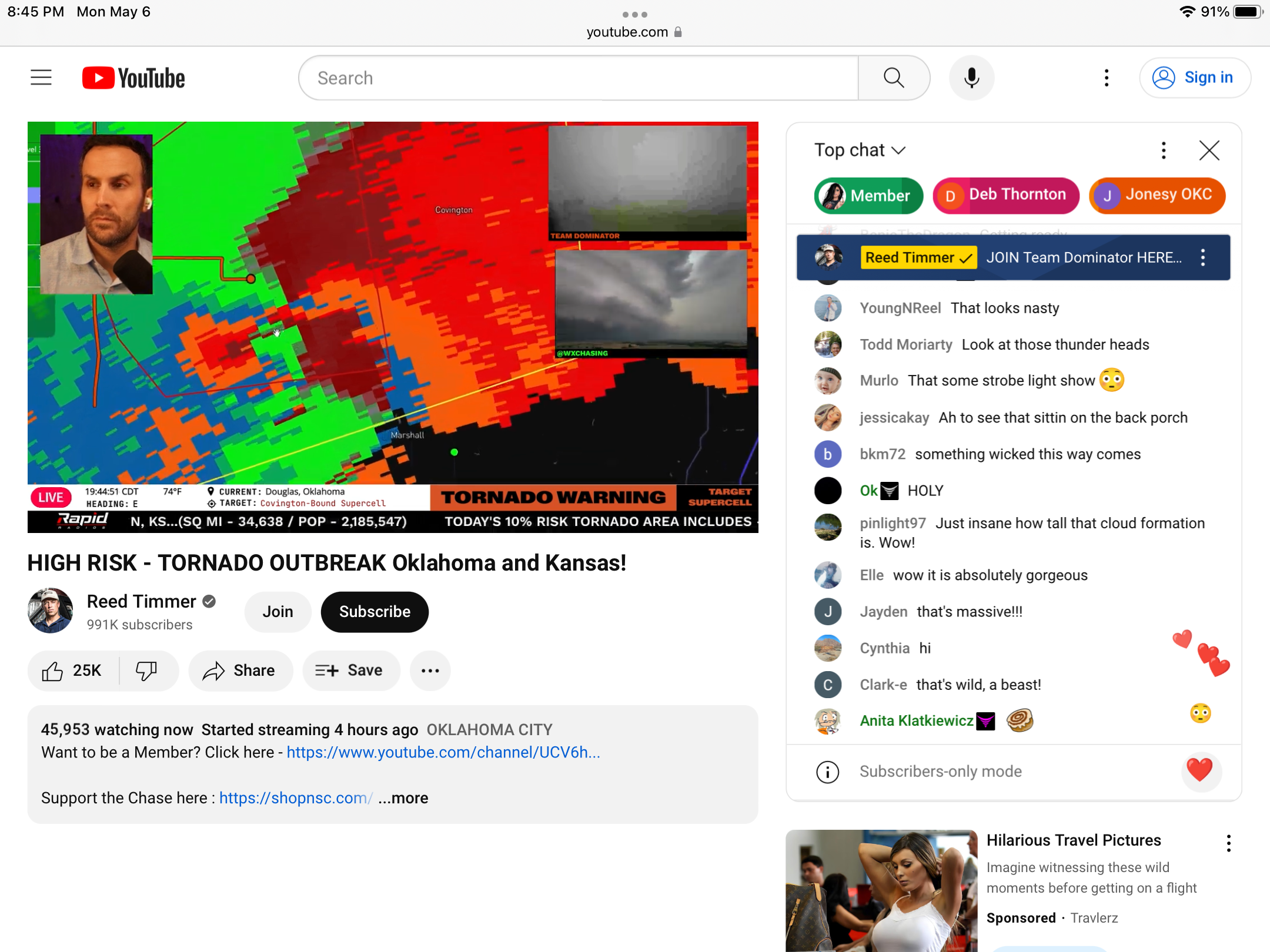
Here is a YouTube live storm chasing site
-
Severe Weather 5-6 through 5-9-24
hudsonvalley21 replied to cheese007's topic in Central/Western States
-
May 2024 temperature forecast contest
hudsonvalley21 replied to Roger Smith's topic in Weather Forecasting and Discussion
DCA _ NYC _ BOS __ ORD _ ATL _ IAH __ DEN _ PHX _ SEA 0.9 1.0 1.8 2.2 1.3 1.4 0.8 0.3 1.2 -
33 for the low here. Point n click forecast is for a low of 32 for tonight.
-
33 for the low here. Point n click forecast is for a low of 32 for tonight.
-
Have a great time on your sortie.
-
Hopefully not too much damage.
-
Felt it up here in the Hudson valley, Must have felt it for being close to the ramapo fault line.
-
DCA: +3.1NYC: +4.2BOS: +4.1ORD: +3.2ATL: +2.1IAH: +2.6DEN: +2.7PHX: +2.3SEA: +2.9
-
2.77” is the total here.
-
35 degrees here currently. 0.95” in the Davis so far. No ice accretion on any surfaces here at 125’ in elevation.