hudsonvalley21
-
Posts
4,265 -
Joined
-
Last visited
Content Type
Profiles
Blogs
Forums
American Weather
Media Demo
Store
Gallery
Everything posted by hudsonvalley21
-
Thanks for the heads up Walt. Then we go cold Sunday night with the cold front that comes thru keeping the frozen accumulations that we have left (especially for us interior folks) for some time and whatever happens around the 20th.
-
And now it’s 8 days out. It’s seldom this far out that it verifies. Once in a while a dog gets its bone. The million dollar question is when.

-
All snow here quick dusting on all surfaces. 29/16
-
Amazing
-
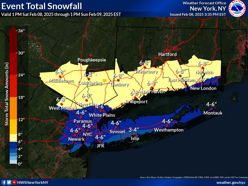
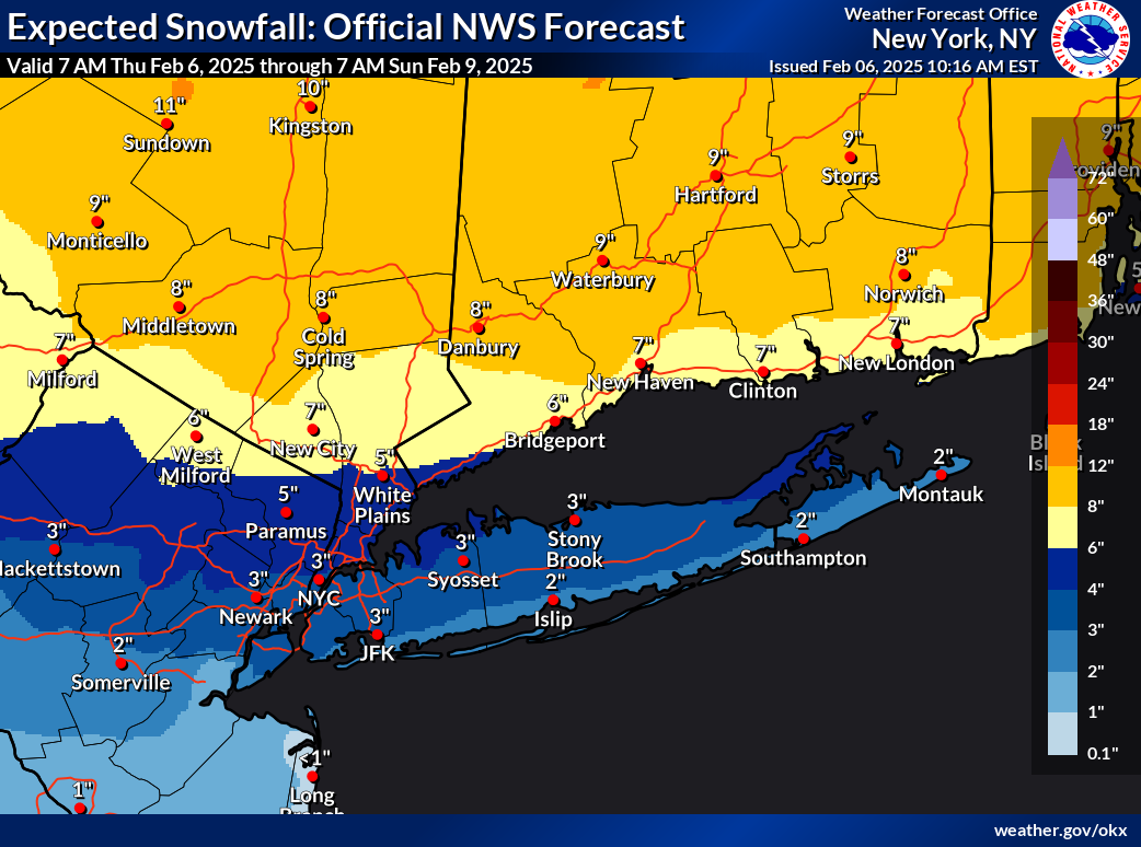
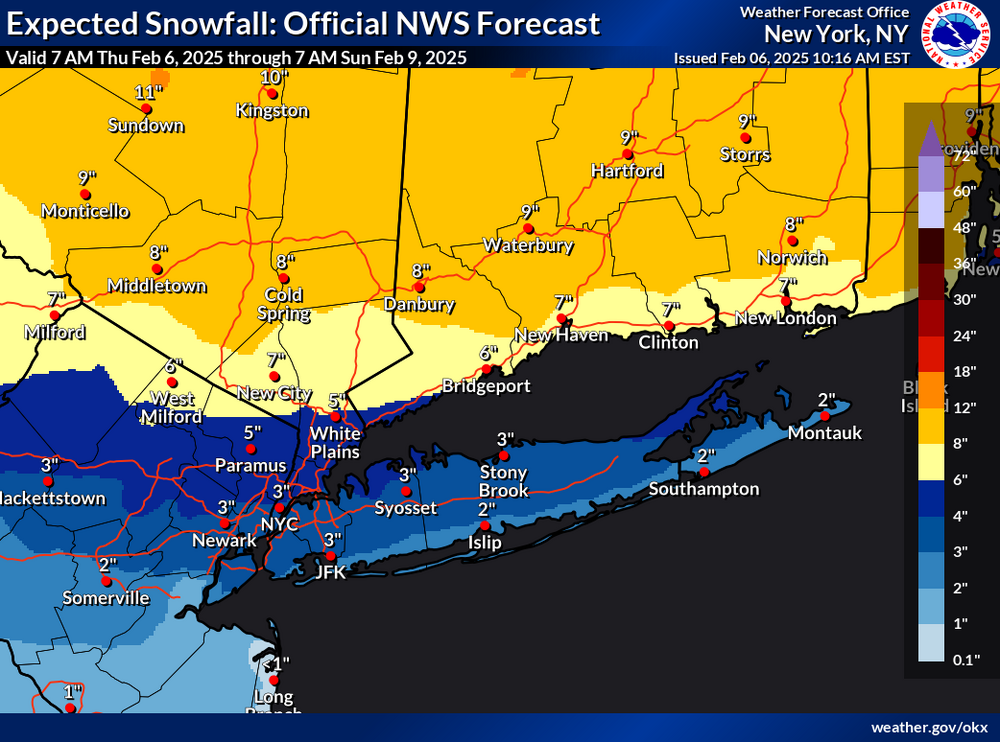
Here’s the latest map from Upton,

-
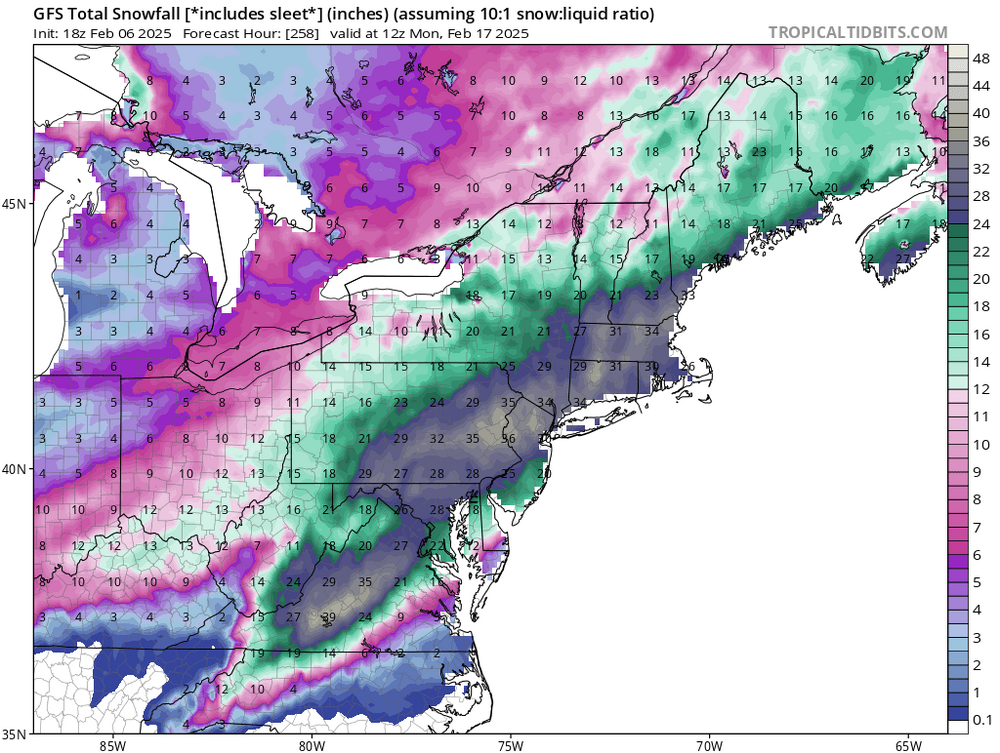
Hope you enjoy your dinner and walk. It’s crazy that the GFS runs for the last several days have been pretty consistent with the QPF and snow amounts. What a pattern we are in.
-
Upton’s snow map for the Saturday/Sunday event.

-
Point n click forecast for MBY in Orange County Saturday A 20 percent chance of snow after 1pm. Partly sunny, with a high near 35. Light and variable wind. Saturday Night Snow before 4am, then snow and sleet. Low around 26. Chance of precipitation is 100%. New snow and sleet accumulation of 5 to 9 inches possible. Sunday A 50 percent chance of snow before 11am. Cloudy, then gradually becoming mostly sunny, with a high near 37.
-
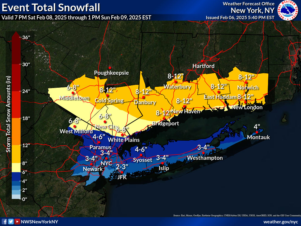
Upton’s latest snowfall map for this weekend. The valid time is from 7am today thru 7am Sunday.
-
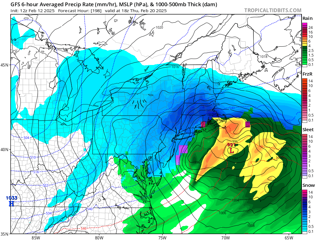
3rd wave not looking too bad, maybe some mixing issues for NYC. Subject to change of course.
-
Thanks again Walt for your time to post and sharing your thoughts and expertise. I also got fuel for the Ariens and did a once over on the belts and sheer pins. Fresh oil and ready to go for a good workout for it in the week or so to come. One thing is certain, this will definitely help increase the levels in the reservoirs.

-
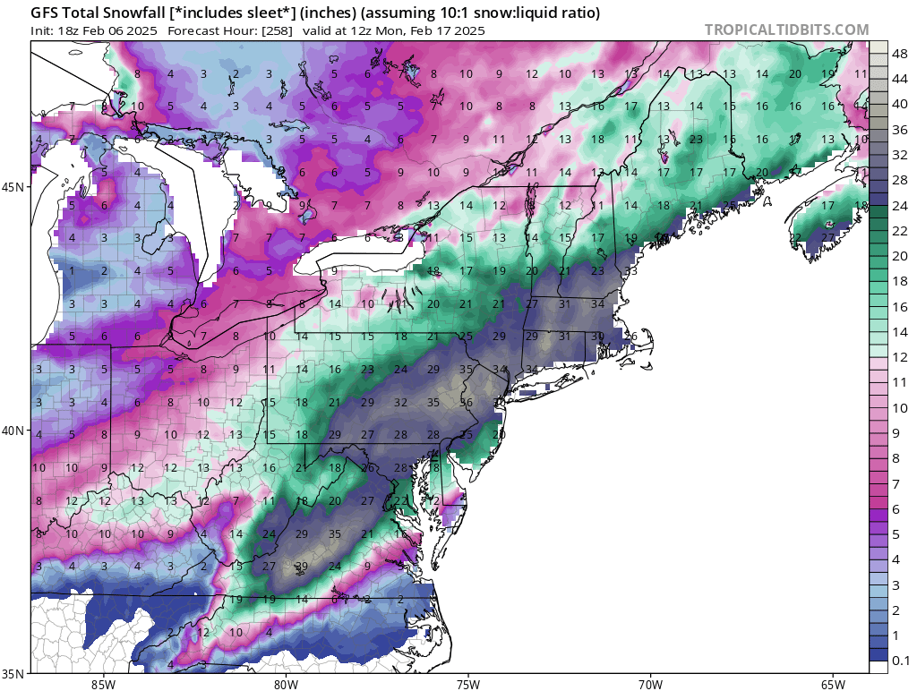
Crazy that it has been bullish for the last few runs. Like you said, we’d take half of that.
-
Wait a few more days and see how things look on Thursday before going all in.

-
Also looking at radar, it appears that this will be just about thru the area by midnight or so. 25/23
-
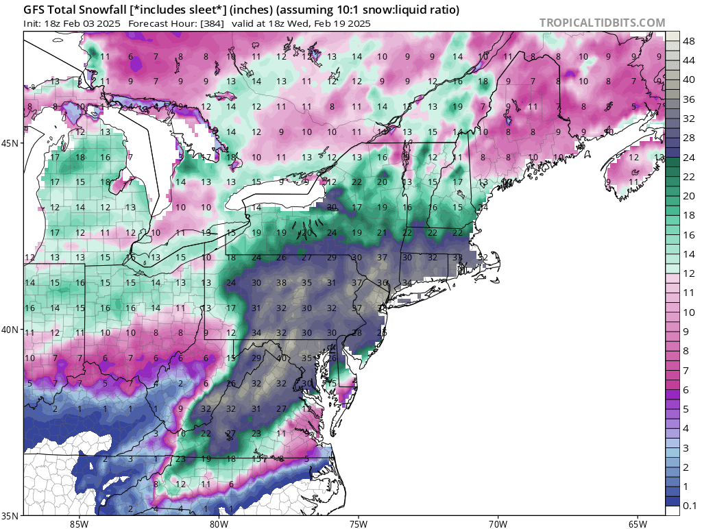
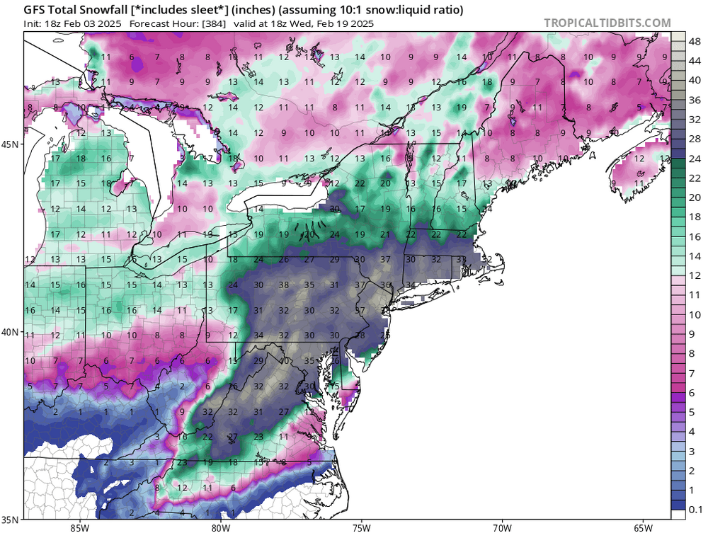
Tropical tidbits is stuck on hr 168 for total snow on the 18z run for the GFS.
-
Area Forecast Discussion National Weather Service New York NY 345 PM EST Sun Feb 2 2025 .SYNOPSIS... A warm front lifts through tonight followed by a cold front on Monday night. High pressure returns Tuesday into Wednesday. A complex frontal system then approaches late Wednesday and impact the area from Wednesday night into Thursday. High pressure will return on Friday before another frontal system next weekend. && .NEAR TERM /UNTIL 6 AM MONDAY MORNING/... A Winter Weather Advisory is in effect for interior southern CT. A mid-level shortwave approaches this evening along with a warm front at the surface. Vertical forcing with mid level positive vorticity advection will result in widespread precipitation from west to east tonight. For the Lower Hudson Valley, southern CT and much of northeast NJ, this is expected to fall as all snow. For Long Island, coastal CT and the NY/NJ metro area, with warming surface and boundary layer temps from a southerly flow, precip may start as snow and then turn to a wintry mix and or all rain. The shortwave has had a very subtle strengthening trend across much of the guidance over the past several model cycles. This may be the reason for the upward trend in QPF across the 12z guidance. QPF totals were bumped up to 0.25 to 0.30 inches over southern CT, with 0.10 to 0.20 inches elsewhere. With these totals in CT, even being conservative with SLRs (10-12:1) would result in around 3 inches of snow (Advisory criteria) across the interior. For this reason, issued an Advisory there. Higher SLRs are not out of the question as the 12z hi res guidance agreed on a 1-3 hour window with strong lift maximized in the DGZ. This would lead to a period of moderate snow and snowfall rates close to 1 inch per hour. Farther west, across the Lower Hudson Valley, lift is weaker and QPF is lower. This is likely a result of the orientation and timing of the LLJ. Totals here will be closer to 1-2 inches, with isolated 3 inch amounts. As the precip tapers off after midnight, the mid levels dry out and this may result in a period of lingering patchy freezing drizzle across the interior into early Monday morning. Confidence in this is low and will be monitored for a potential Special Weather Statement.
-
February DCA _ NYC _ BOS __ ORD _ ATL _ IAH __ DEN _ PHX _ SEA 2.6 1.9 2.1 2.2 2.6 2.0 1.6 0.2 -0.9
-
It just pushed thru here IMBY. A quick 2 minute snow shower along with a 30 mph wind gust. Skies are clear now with the winds still gusty.
-
+8 for the low here.
-

-
Same here with the low and current temperature. I have a heat pump for the pool, same thing as for the warmer air temps when heating up the water, it’s happier too.