hudsonvalley21
-
Posts
4,276 -
Joined
-
Last visited
Content Type
Profiles
Blogs
Forums
American Weather
Media Demo
Store
Gallery
Everything posted by hudsonvalley21
-
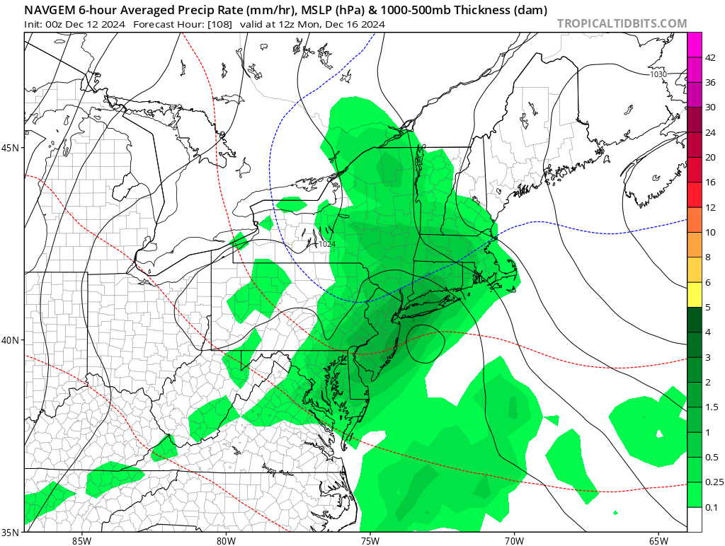
Thanks Walt, something to keep an eye on.

-
I think he did.

-
I’ll see if I can shovel it out
-
0.63” here, light rain currently. 36/35
-
DCA _ NYC _ BOS __ ORD _ ATL _ IAH __ DEN _ PHX _ SEA 0.6 0.5 0.2 0.2 0.7 1.0 0.2 0.9 0.1 DCA _ NYC _ BOS __ ORD _ DTW _ BuF __ DEN _ SEA _ BTV 17” 21” 28” 26” 24” 102” 51” 4” 84”
-
Just a dusting here at 125’ in elevation. Had 1.22” yesterday in precipitation. 1.17” since midnight today. So 2.39 in the Davis. I wonder if at the top of Storm King mtn. at 1,220’ has the 12” there too.
-
NJZ002-NYZ067>070-221200- /O.NEW.KOKX.WW.Y.0006.241122T0000Z-241122T1500Z/ Western Passaic-Orange-Putnam-Rockland-Northern Westchester- 326 PM EST Thu Nov 21 2024 ...WINTER WEATHER ADVISORY IN EFFECT FROM 7 PM THIS EVENING TO 10 AM EST FRIDAY... * WHAT...Snow expected. Snowfall accumulations will be highly elevation dependent. Total snow accumulations of 2-4 inches at elevations above 500 feet, with the highest amounts above 1000 feet. Elsewhere, accumulations will likely be less than 2 inches. * WHERE...In New Jersey, Western Passaic County. In New York, Northern Westchester, Orange, Putnam, and Rockland Counties. * WHEN...From 7 PM this evening to 10 AM EST Friday. The heaviest snow will likely fall between 11 PM and 6 AM. * IMPACTS...Plan on slippery road conditions. The hazardous conditions could impact the Thursday evening and Friday morning commutes. Isolated tree damage and power outages are possible due to heavy wet snow load.
-
The elevation is key with this event.
-
Upton’s thoughts, A section of their AFD CAMs and regional models have diverged somewhat on the position of the movement of the low tonight. Some of the CAMs bring the center of the low just north of our area and a little to the east into the early night before having it retrograde to our west in Upstate New York while other just stick with tracking the low to our northwest. The more northeasterly track, regardless will only occur this evening into early tonight before bumping west. With the low tracking north of us this evening, cooler air will take over this evening with temperatures near or below freezing in interior locations north and west of NYC. Prior to this, temperatures will be in the 40s. A transition from rain to snow is expected this evening for interior areas north and west of NYC, but given the warm temperatures prior, snowfall may struggle to accumulate. Its possible we could see a few heavy bands of snow with snowfall rates around 1-2"/hr this evening into early tonight indicated by the 00Z HREF and a saturated dendritic growth zone before the precip gets cut off by a dry pocket of air that moves in when the low retrogrades westward into upstate New York. This dry air is easiest to see when looking at model soundings or at model 700 mb relative humidity. Higher elevations in interior locations northwest of NYC will most likely see accumulations of 1-4 inches. Western Passaic, Orange and Putnam Counties are now highlighted in the HWO for this potential. However, most of the interior northwest of NYC is at lower elevation and only a trace to 0.5" is expected due to warmer ground melting the snow and a short window for snow banding before the precip becomes much lighter from dry air intrusion. Snow ratios are also expected to be on the low side, further contributing to lower snow accumulations compared to what some of the CAMs are producing with 10:1 Snowfall.
-
A section of Upton’s AFD, CAMs and regional models have diverged somewhat on the position of the movement of the low tonight. Some of the CAMs bring the center of the low just north of our area and a little to the east into the early night before having it retrograde to our west in Upstate New York while other just stick with tracking the low to our northwest. The more northeasterly track, regardless will only occur this evening into early tonight before bumping west. With the low tracking north of us this evening, cooler air will take over this evening with temperatures near or below freezing in interior locations north and west of NYC. Prior to this, temperatures will be in the 40s. A transition from rain to snow is expected this evening for interior areas north and west of NYC, but given the warm temperatures prior, snowfall may struggle to accumulate. Its possible we could see a few heavy bands of snow with snowfall rates around 1-2"/hr this evening into early tonight indicated by the 00Z HREF and a saturated dendritic growth zone before the precip gets cut off by a dry pocket of air that moves in when the low retrogrades westward into upstate New York. This dry air is easiest to see when looking at model soundings or at model 700 mb relative humidity. Higher elevations in interior locations northwest of NYC will most likely see accumulations of 1-4 inches. Western Passaic, Orange and Putnam Counties are now highlighted in the HWO for this potential. However, most of the interior northwest of NYC is at lower elevation and only a trace to 0.5" is expected due to warmer ground melting the snow and a short window for snow banding before the precip becomes much lighter from dry air intrusion. Snow ratios are also expected to be on the low side, further contributing to lower snow accumulations compared to what some of the CAMs are producing with 10:1 Snowfall.
-
.93 45/43. Light rain currently.
-
Definitely possible. Up this way we had snow around Halloween a few years ago. Huge change from 7 days ago. Great help for the brush fires and the reservoirs.
-
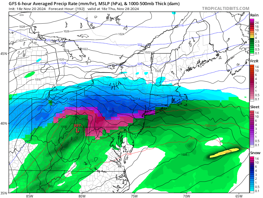
As of the 18z run, it’s just under 200 hours out. Subject to change as usual.
-
Sure Walt, start a thread. Concerned about flooding, runoff with the hard ground an a good amount of QPF in a short time.
-
Absolutely, either rain,snow,or white rain, as long as it’s not a heavy short timed event. A slow soaking would be great to soften up the bone dry hard surface. 1-2” of QPF as of todays 18z runs thru Friday is great. Hopefully they hold serve.
-
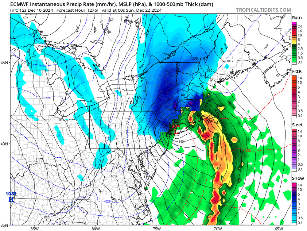
A section of Upton’s AFD LONG TERM /WEDNESDAY THROUGH SATURDAY/... Models in good agreement with an anomalously deep closed upper low (2-3 standard deviations below normal heights) digging into the Ohio/Tennessee Valley Wed Night into Thu, lifting into the NE US on Friday, and then stalling over the NE US into the weekend. Global models have trended over the past 24 hours with a weaker surface low development over the Great Lakes and a stronger secondary low taking shape right over us late Wednesday night into Thursday. This will therefore be the period when rainfall chances will be at the highest. Can`t even rule out an isolated thunderstorm with the strengthening low center passing through coinciding with a little elevated instability. NBM probability of 1+ inches of rain Weds night through Thursday has increased to 30-50%, with deterministic models in pretty good agreement that we pick up 0.75 to 1.50 inches of rain during this time.
-
Let’s hope the rain will come in Wednesday night. Yup, Excellent job in Greenwood Lake last night.
-
With the fires jumping and moving and moving in several directions could be from underneath spread and elevation changes. They called a couple of Rockland County units in tonight as well. I believe that the evacuation became mandatory from previously being voluntary in one area. Also haven’t heard of the air tankers arriving also. The water drops of 350 gallons each take care of the surface but don’t penetrate far into the ground.
-
I’m kind of surprised that it jumped the line. Not sure what the winds are down there currently, winds were around 10-15 most of the day IMBY. Could be possible that it’s burning under ground and popped up past the back burn areas, only speculating. Haven’t seen any recent videos from the area. Hopefully they can keep ahead of it.
-
.01
-
Yup with the rockland companies covering for structure protection. Every Orange County department has been requested to send available manpower and equipment. Everyone is stretched thin currently. Hopefully the rain can knock down some tonight before the wind shift tomorrow and forecast winds to be 10-15. https://www.facebook.com/FDWCompound/posts/pfbid04yZfZcPruTDnsgTVTiSkrWCtUMVnDDLqaMm5LGG6h4pAUGS9N6u4n137JsDNqKGPl?__cft__[0]=AZVfJZ6ILcPRXS9hdXWROTwGicNTKxhH887DRP822S7eLotd1JJXhp5rD1a8QY9yDmdGUil2agt5oS803RYLoK8X6he8V-LSZxKWuHkNmZXR2gAeY8FmKDLgNI3TeHe6_AeaWvbF_sBjP2loNjtEKd53euPEnVuFNr0KRQSrmdTVxmYJmyZ-bufIy53ojHQjAZXLJfQtTfzeWGwJR7T_w7fWyw_xvQ4W99w_H8WpYMRQ_A&__tn__=-UK-R
-
So far the rain is very light. Only a trace here so far as of 7pm. The fire at Greenwood Lake had me smoke and some light ash. A far cry from folks living in that region. 3,000 acres burned so far with 10% containment and 1 loss of life from a firefighter . Thoughts and prayers and hopefully some desperately needed rain. https://www.facebook.com/NJForestFireService/posts/pfbid05iNfd4FWprJdQ3HCdBcSyY27Ka9efCdLiTaCvLQE9c3234Qct6TzwfHXEmXWpDD5l?__cft__[0]=AZWDDsHVPLbd3-nWn3Q0SOEjTjQFwEFkMRGBce6SeZHEQzVbHLCZgD_DF5e4Ex63WyX0Q-qhB-qpJYteb_9MWvA0lyqkWv_d4zRKhodoQGdUG-4z46QqhjwdDzTy2HL3X6IlFj5Cv992BbHVPJNLz_DkT9xgANWNaNEqEceMiTmwQEHQgvFmNEyt5Pq1jf9SoZVQaPs93R_r11hULdwlVbI_JhVXuejKihV6cLrQ0Da3BQ&__tn__=-UK-R
-
Nice day to go to the beach.
-
Agree, I was raking leaves in shorts and sweating today. It just ain’t right.