hudsonvalley21
-
Posts
4,265 -
Joined
-
Last visited
Content Type
Profiles
Blogs
Forums
American Weather
Media Demo
Store
Gallery
Everything posted by hudsonvalley21
-
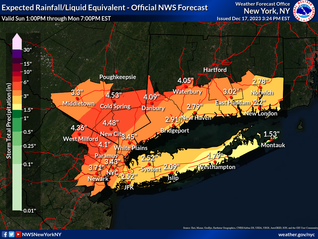
Moderate-High Impact Storm Noon Sun Dec 17, 2023 - 4PM Mon Dec 18. Flooding rain I95 corridor northwestward, coastal tidal flooding, brief periods of damaging 50 MPH+ wind gusts LI/CT Monday, ends as a little wet snow interior elevations Tue morning.
hudsonvalley21 replied to wdrag's topic in New York City Metro
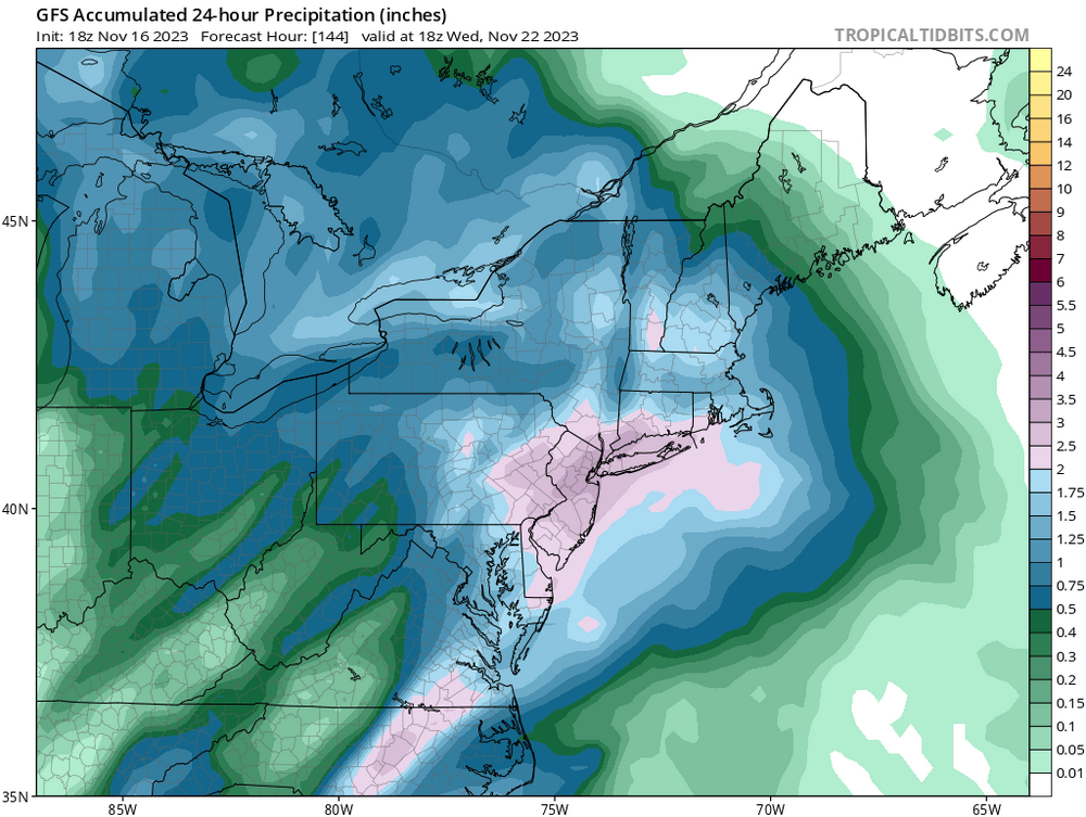
Upton’s latest QPF map has ticked up a little
-
2.06” in the bucket here.
-
Upton put some spotty accumulations up this way.
-
Maybe send him a hat for a prize

-
Agree, it will take awhile for the pac jet to get shifted. So maybe we can get an occasional snow shower/mood flakes. It’s too early in the season to start pulling hairs out of our heads watching each model run. As for the jets, this season they could play sloppy inside a closed dome
-
Mood flakes here currently. Had a quick coating yesterday on grassy surfaces that quickly melted. Maybe I can beat yesterday’s and get a trace of accumulation today.
-
Nice, let’s see what future runs show. 06z GFS is showing a few events too (mostly liquid) always subject to change of course.

-
Coating on grassy surfaces that quickly melted.
-
DCA _NYC _BOS __ ORD _ATL _IAH ____ DEN _PHX _SEA 1.4 0.1 0.4 1.7 1.3 1.1 2.3 1.2 2.7 DCA _NYC _BOS __ ORD _DTW _BUF ____ DEN _ SEA _ BTV 12.0 31.0 30.5 33.5 32.5 68.5 59.5 5.5 77.0
-
Drove thru a snow squall around 11:30 this morning while driving thru Walden. A quick dusting on most surfaces.
-
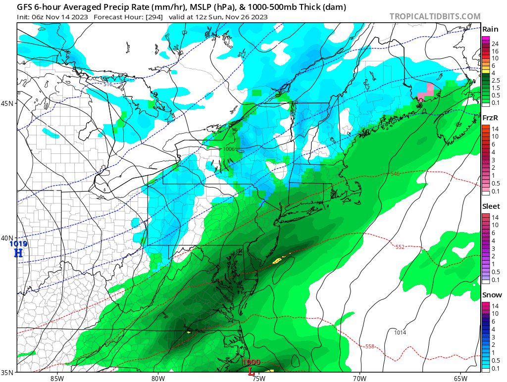
18z GFS is also on board too.

-
06z GFS is showing something at that time. Subject to change of course. We’ll see.

-
No flakes here yet. Low of 22 last night (actually around 6am this morning).
-
No worries, just have a backup plan
-
27 was the low here. Same with the heavy frost and a good amount of plants took a beating.
-
DCA: +0.3 NYC: +0.6 BOS: +0.2 ORD: +0.6 ATL: +1.2 IAH: +0.2 DEN: +0.9 PHX: +1.8 SEA: +0.8
-
He could be making the whole story up because it could have been a total blur
-
Enjoy it while you can.

-
Almost as fake as the GFS map
-
1.23” here, looks like the total for the event.
-
Never heard of them. Looked them up and they could be toxic to humans and pets. https://news.vt.edu/articles/2023/08/hammerhead_worms_expert.html#:~:text=Hammerhead worms are once again,dangerous to humans and pets.
-
My feelings too. Let someone else have it.
-
Subject to change of course.