

olafminesaw
-
Posts
3,052 -
Joined
-
Last visited
Content Type
Profiles
Blogs
Forums
American Weather
Media Demo
Store
Gallery
Posts posted by olafminesaw
-
-
4 minutes ago, Prospero said:
Best of the year even early in its life.
Trying to upload a clip but keep this getting:
Sorry, an unknown server error occurred when uploading this file.(Error code: -200)So here is a link:Looks like the kind of storm that could quickly form a tight core and consolidate after come back over water
-
 1
1
-
-
59 minutes ago, LoboLeader1 said:
That color scale...
-
 1
1
-
-
Good thing the weather's calm...what a massive radar hole

-
Nws putting changed into effect on how severe thunderstorm warnings are communicated

-
29 minutes ago, jburns said:
Ugh. There is my most disliked NWS map. If you took those words and did this….
Enhanced
Moderate
Slight
High
Marginal
….and told people in the general public to rank the words from least to most likely I guarantee that less than 50% would get them correct or rather in the same order as the NWS. Personally I am not convinced myself the moderate is greater than enhanced. Marginal and slight would also generate confusion.
IMO, since the primary mission of the NWS is to get out important and accurate weather information to the general public these rankings fail miserably.
Yeah, moderate as a 4/5 on the scale makes no sense. Moderate has always been a significant severe threat, despite the connotation of the word, and even when they only had three categories was probably a poor choice for communicating threat level to the public. So when they forced in a category between slight and moderate they had to choose something that meant "relatively significant", which sounds more severe than "moderate". But in a perfect world this would make more sense:
Minimal (green)
Slight (yellow)
Moderate (orange)
High (red)
Extreme (magenta)
In reality this would be super confusing to everyone to make a switch, so I kinda feel like they should just refer to the color or number as a threat level.
-
First severe threat In a while, primarily for hail

-
No mention yet of smoke in the RAH disco yet. Should be impacting our area most Wed-Friday. Mostly high level smoke but probably some impact to air quality/visibility.
-
At GSO airport the total for the month has risen to 5.19", with 2.96" coming over the past three days.
This puts us ahead of average by about 4" on the year, well on our way to yet another wetter than normal year. At this time in 2018 (the year of the all time rainfall record), Greensboro was actually slightly below normal rainfall.
-
13 minutes ago, magpiemaniac said:
I was actually a little lucky this evening. After a few near misses, I was able to get in on the edge of a couple of cells and ended up with 1.11”. I missed out on the big totals, but I’ll take it.
Same here pretty much, on the edge of the good stuff, but it added up. The plus side is it gives the ground time to soak it all up.
-
1
-
-
16 minutes ago, NorthHillsWx said:
Definitely better coverage than I was expecting in western areas
I think just a bit of unforecasted shear did the trick. But for now, it's stayed just east of me. Surprise surprise
-
2 hours ago, buckeyefan1 said:
I can not wait for this! It's in April near my birthday, so while I'd love to go hang out with my fellow weather nerd peeps in the midwest or northeast, I'm going to harass Cory in Texas
 I've been warning him since the last total eclipse
  @Avdave @Isopycnic @jburns @Fozz Maybe if we all gang up on him he'll let us camp out at his place for the day
Yeah, I've never seen the totality, so I'll do what it takes to see it in 2024. Last chance in a long time
-
1
-
-
Since the weather is as boring as can be, here's a fascinating article about cloud cover climatology for the 2024 eclipse:
-
7 minutes ago, magpiemaniac said:
I’m both grateful for and underwhelmed by the 0.37” of rain that I received today. RAH called for about 1.6” here based on the consensus of the modeling for most of yesterday. Not even close. This one went wide right…or east in this case.
My July total is now at 3.23” with almost all of that coming on the 1st and 2nd.
They did a good job, choosing the east side of guidance. Consensus of the models was for about 2-2.5"
-
1 hour ago, nwohweather said:
Watching with intrigue here this evening in Charleston. Would not be shocked to see some tornadoes
Hmm... Interesting indeed
.thumb.png.f71b9517fa88ec4e5a77315b8e1f13b5.png)
-
-
Looking good

-
13 minutes ago, magpiemaniac said:
The 11:00 AM cone definitely took a westward shift to the west compared to 8:00 AM. Still expect RAH to ignore the models and NHC guidance and forecast 0.1” of light rain for me. j/k
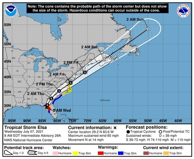
Haha, and I expect them to be right too! We've found so many creative ways of having boring weather around here lately
-
I wouldn't be surprised if wind gust end up higher for eastern NC than they were for most of the Florida coast
-
Let the hallucinations commence! Seriously though, it's going to be a real close call for Tampa proper, saint Petersburg/Clearwater will bear the brunt of the wind I think. Max surge is just about locked in for the bay. Hard to believe the worst is still hours away for Tampa, as close as it appears
-
1
-
-
12 minutes ago, Master of Disaster said:
Is Josh down there?
Yeah, he decided last minute, so he's rushing to get to the landfall point
-
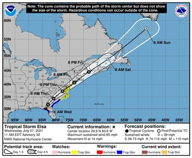
Hurricane warnings issued for Tampa and up the coast. Elsa is now forecasted to reach hurricane strength very soon
-
Nothing to support an upgrade in the most recent pass, 60 kt max winds and pressure holding steady
-
7 minutes ago, NorthHillsWx said:
Yea the radar velocities would seem to indicate that this is likely a hurricane, and if this storm continues to pull *some* convection westward enough to maintain that strong band near the center, the hurricane hunters will likely verify this is a minimal hurricane at this juncture. I’m pretty sure this is about the ceiling for Elsa though and that “eyewall” is very fragile. This will likely go through periods where the shear wins and it erodes just to have another convective burst make another attempt. In other words, she’s likely a minimal hurricane right now and I’d be expecting fluctuations in intensity through landfall though I could also see weakening once it passes Tampa and a lot of the circulation moves on land. Impacts will be the same regardless
I figure they will be conservative and call it a 70 mph TS, even if there is reasonable evidence to upgrade, for this very reason. They don't want to have to downgrade a few hours later and confuse the public.
-
1
-
-
You can see on visible, the convection being sheared to the east. If anything, this enhances the flood threat, especially inland.
-
 1
1
-


.png.d597742c7dd3bc89b300fb83eac1002b.png)

Major Hurricane Grace
in Tropical Headquarters
Posted
They don't think it be like it is, but it do.
I feel like the HWRF actually had zero use other than for mature systems