

olafminesaw
-
Posts
3,060 -
Joined
-
Last visited
Content Type
Profiles
Blogs
Forums
American Weather
Media Demo
Store
Gallery
Posts posted by olafminesaw
-
-
-
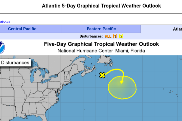
95L is trying to be the longest surviving cherry ever
-
 1
1
-
-
First wedge of the year! (Yay)
Easier to scour out this time of year, but still. Wouldn't be surprised to see temps stay in the mid 70s today in the Triad
-
8 hours ago, WxWatcher007 said:
With an invest declared and guidance really focusing on development now, it's time to discuss.
So discuss

No thanks
What a sad system
-
 1
1
-
-
24 minutes ago, Windspeed said:
Are those your tweets? I've interacted with your tweets a few times over the years. "yconsor", "jconsor", I suppose that didn't require much detective work there. lol..
At any rate, Larry is looking better on satellite today, even improved in a way that an eyewall may be rebuilding. Recon should be interesting. If a strong eyewall exists, those 100+ kt 850 hPa winds may start mixing down better.
Additionally, Larry still has several days to traverse sufficiently warm SSTs for reintensification given that it will be moving at a quicker pace. Shallow OHC, even at 27°C will support sufficient lapse rates in a large hurricane if it is moving fast enough and has adequate baroclinic support, which it looks like Larry will be given excellent support. Think Lorenzo in 2019. It was large and yet with excellent atmospheric dynamics pulled off Cat 5 intensity with shallow ~27°C SSTs. Larry has a larger/broader circulation than Lorenzo however, so I do not think it could pull off high end intensity of Category 4, but it certainly could tighten the gradient enough to regain major hurricane status.
Seems typically with a large, tilted, fast moving system you tend to see more wind field expansion than an increase in max winds. But I suppose possible the eyewall could reorganize somewhat
-
3
-
-
*sad cricket noises*
Anyway, with the MCS that moved through, I doubt we will hit our forecast high of 86 in the triad. Muggy muggy though
-
125
115
940
Cocodrie
-
Hilly terrain, up to about 1000 ft, should halt intensification somewhat for at least a few hours. But hard to believe it will have much of an impact long term
-
3
-
-
1 minute ago, MJO812 said:

The GFS had been pumping out lots of gulf systems a couple days back as well. The signal is there
-
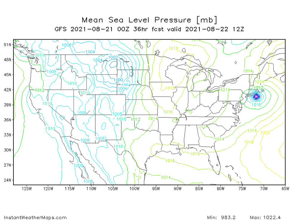
GFS at 33 a tou ch east of 18z. heading for a landfall just east of LI i think
-
1 minute ago, MattPetrulli said:
Why am I watching a NAM play by play of a tropical system
Because it's the first model to run and addicts need their fix. Kinda like the SREF for snowstorms. I much prefer looking at the 3km version if I want my fix of complete nonsense
-
2
-
2
-
-
4 minutes ago, NeonPeon said:
Gravity waves are fun, but the center still isn't the center, or close to it, thankfully. All that stuff is southeast.
Certainly true that it's not yet aligned. But the center is under the edge of the convection and even though convective bursts don't last forever, it should help the system align. Shear is definitely lessened
-
2 minutes ago, David-LI said:
Mind sharing website you're using to track?
https://weather.cod.edu/satrad/?parms=meso-meso2-14-24-0-100-1&checked=map&colorbar=undefined
-
1
-
 1
1
-
-
Wow, last few frames convection really started pushing north over the LLC. May be all systems go at this point
-
1 minute ago, qg_omega said:
usually, given how slow and small it is. Without ET help, this will quickly loose all its convection and will just be a low level swirl with low top convection to its east. Will looks very impressive on visible and very anemic on IR.
You see this all the time as Typhoons recurve past Japan. They normally do ramp down pretty quick, but can bring pretty strong winds while looking pathetic on IR
-
6 minutes ago, WxWatcher007 said:
Latest dropsonde. Need to see more to make sure it's actually representative of the wind field but this would have it close to hurricane status.
Product: Air Force Temp Drop (Dropsonde) Message (UZNT13 KNHC)
Transmitted: 20th day of the month at 12:14Z
Agency: United States Air Force
Aircraft: Lockheed WC-130J Hercules with reg. number AF97-5304
Storm Name: Henri
Storm Number: 08 (flight in the North Atlantic basin)
Mission Number: 4
Observation Number: 07 ( See all messages of this type for this mission. )
Part A...
Date: Near the closest hour of 12Z on the 20th day of the month
Highest Mandatory Level For Which Wind Was Reported: 925mb
Coordinates: 29.3N 73.1W
Location: 394 statute miles (634 km) to the NE (42°) from Nassau, Bahamas.
Marsden Square: 080 ( About )
Surface and Standard Isobaric Surfaces Level Geo. Height Air Temp. Dew Point Wind Direction Wind Speed 1006mb (29.71 inHg) Surface (Sea Level) 23.4°C (74.1°F) 21.9°C (71°F) 190° (from the S) 63 knots (72 mph) 1000mb 54m (177 ft) 22.6°C (72.7°F) 21.3°C (70°F) 190° (from the S) 64 knots (74 mph) 925mb 734m (2,408 ft) 21.0°C (69.8°F) 19.9°C (68°F) 210° (from the SSW) 66 knots (76 mph) 850mb 1,464m (4,803 ft) 17.6°C (63.7°F) 17.1°C (63°F) No Wind Report Available For This Level
Information About Radiosonde:
- Launch Time: 11:54Z
- About Sonde: A descending radiosonde tracked automatically by satellite navigation with no solar or infrared correction.
Remarks Section...
Dropsonde Location: Dropped in maximum wind band.
Highest altitude where wind was reported:
- Location: 29.31N 73.06W
- Time: 11:54:31Z
Lowest altitude where wind was reported:
- Location: 29.34N 73.04W
- Time: 11:56:50Z
Mean Boundary Level Wind (mean wind in the lowest 500 geopotential meters of the sounding):
- Wind Direction: 195° (from the SSW)
- Wind Speed: 67 knots (77 mph)
Deep Layer Mean Wind (average wind over the depth of the sounding):
- Wind Direction: 210° (from the SSW)
- Wind Speed: 60 knots (69 mph)
- Depth of Sounding: From 844mb to 1006mb
Average Wind Over Lowest Available 150 geopotential meters (gpm) of the sounding:
- Lowest 150m: 155 gpm - 5 gpm (509 geo. feet - 16 geo. feet)
- Wind Direction: 190° (from the S)
- Wind Speed: 65 knots (75 mph)
Sounding Software Version: AEV 30404
Part B: Data for Significant Levels...
Significant Temperature And Relative Humidity Levels Level Air Temperature Dew Point 1006mb (Surface) 23.4°C (74.1°F) 21.9°C (71°F) 979mb 21.0°C (69.8°F) 19.7°C (67°F) 951mb 22.6°C (72.7°F) 19.8°C (68°F) 850mb 17.6°C (63.7°F) 17.1°C (63°F) Significant Wind Levels Level Wind Direction Wind Speed 1006mb (Surface) 190° (from the S) 63 knots (72 mph) 997mb 190° (from the S) 64 knots (74 mph) 985mb 195° (from the SSW) 71 knots (82 mph) 951mb 200° (from the SSW) 64 knots (74 mph) 933mb 210° (from the SSW) 63 knots (72 mph) 927mb 210° (from the SSW) 67 knots (77 mph) 920mb 215° (from the SW) 62 knots (71 mph) 911mb 215° (from the SW) 64 knots (74 mph) 900mb 215° (from the SW) 57 knots (66 mph) 886mb 225° (from the SW) 61 knots (70 mph) 860mb 235° (from the SW) 52 knots (60 mph) 855mb 240° (from the WSW) 56 knots (64 mph) Seems to support FL wind data. I would go 70 mph
-
Looks like there's some Saharan dust on pushing in from the South East of the circulation. Any chance it gets ingested and effects the system?
-
 1
1
-
-
When's the next recon? Seems like really infrequent recon for a possible landfilling US cane
-
Late to release, the 12z UKMET ensembles:

-
2
-
-
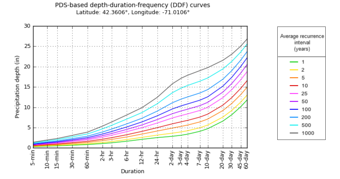
yeah, a foot of rain at just about any interval is really rare for boston.

-
1
-
-
I'm guessing recon data will be integrated in the 0z suite?
-
6 minutes ago, Difflock said:
how reliable is the UKMET??
Best used for sniffing out alternative solutions IMO, which means it's definitely way off base sometimes
-
6 minutes ago, Eskimo Joe said:
On tropical tidbits, am I missing something, or is the 12z Euro just shearing Henri apart by HR72 apart to nothing and kicking it well out to sea?
It intializes way too weak. It's at 1012 mb at 11 am, while the 11 am advisory has it at 998 mb
-


Major Hurricane Sam
in Tropical Headquarters
Posted
Anything beyond this is speculation, but... intriguing nonetheless