

olafminesaw
-
Posts
3,052 -
Joined
-
Last visited
Content Type
Profiles
Blogs
Forums
American Weather
Media Demo
Store
Gallery
Posts posted by olafminesaw
-
-
1 hour ago, PrinceFrederickWx said:
@olafminesaw is gonna thread the needle on this, I can see it.

Just need DCA to be the jackpot on a March snowstorm. How hard could it be?
-
 1
1
-
 1
1
-
-
2 minutes ago, magpiemaniac said:
While looking at various stations this morning, I noticed a wide variation in temperatures over a short distance. I’m 36.1 while airport is 29. One station near me is 35.8 while another is 30.9.
Definitely a classic case of radiation cooling with clear skies and calm winds. Low spots significantly cooler. Made for some heavy frost and icy spots from runoff. Today and tomorrow are classic coat in the morning, t-shirt in the afternoon weather.
-
1
-
-
EPS Mean snow depth for next week

-
1
-
-
1031 high in the ohio valley with a low developing in Louisiana on the Euro.
Checks chip stack....shoves all in
Edit: welp, high slides east and another ice storm for us (and yes, I realize models are mostly useless at this range)
-
2
-
-
4 minutes ago, Suncat said:
I'm not gonna get sucked in...I'm not gonna get sucked in...I'm not gonna get sucked in...
I'm usually fully convinced this will be the time I won't get sucked in, but... approximately one model cycle later I'm fully emotionally invested. Might as well go full weenie now and get it out of the way
-
2
-
 2
2
-
-
13 hours ago, PrinceFrederickWx said:
You all seem to be ignoring @olafminesaw creeping up
Eta: wait... I’m not even sure he can still win? @RodneyS can I get a ruling on this?
Run from it..dread it...
Destiny arrives just the same
-
1
-
-
Setting aside the noise in the models, 35/22 i(at the airport) s a pretty good place to be (several degrees cooler than the HRRR). My only thought is if precip holds back, dewpoints may have a chance to creep up without a corresponding drop in temperature.
-
18z models trended a touch warmer

-
Looks like clouds may hold off until well after sunset north of I40.

-
7 minutes ago, NEGa said:
I do too. It is also something I have been thinking about (the 10-20 years ago storms). 10 -20 years ago almost all wedges and CADs ended up colder than the models were showing, which is where we all got the "it will trend colder" from. Sometimes significantly and markedly colder. however, for the last couple of years, we all talk about the trending colder and expect it yet it is just not happening and a lot of us end up at 33 or 34 with rain. the models still aren't that great, but they do appear to be handling the colder air a bit better. I cannot really remember a storm in the last couple of years that trended much colder and ended up with a surprise storm or more ice than anticipated.
while I remain optimistic and hopeful, I am no longer really all that convinced about the "trending colder" for CADs any more. I take a lot of it with a grain of salt - in the early 2000s it was almost always fun to track CADs and post temps/dewpoints and watch as a lot of the people on the boards as it happened. It just doesn't seem to do this now and we can never get the trend to shave off the final few degrees we need.
(this post is referring generally to ne ga and the upstate, not the higher parts of NC)
I think where we do see this sometimes is the persistence of the wedge despite strong WAA aloft. The models erode the cold too quickly, even in the short range. I think a couple general rules of thumb are that during these kinds of events, where the temp ends up after the column is fully saturated is where it tends to stay. I could see places in the triad staying in the 30-31 range all day long, but never really dropping below 30.
Also, it seems plausible that we would see some sleet, which the HRRR is picking up on. THe opposite happens a lot where a sneaky warm layer leads to sleet, but we may have a sneaky cold layer that makes for sleet instead of ZR (see sounding below). Finally the drying trend has been real. This is the main culprit for why the raw zr outputs have decrease for many. I suspect, in the end this will lead to a more impactful event , with more time for accreation, except for those in the zone between Wilkesboro and Winston, where it may stay relatively dry.

-
1
-
-
Wedge really building in at the end of the run

-
Just now, eyewall said:
We have seen it before this winter with the models getting aggressive only to pull back a bit northwest at the last minute. RAH busted on a few winter storm warnings this year because of that.
The thing is, storm track doesn't make much of a difference, with the high locked in place. Of course, it's quite possible the models are overdoing the strength of the wedge, but I wouldn't count on it.
-
1
-
-
At this point, it's equally important to track dewpoints and cloud cover throughout the day as it is to look at the models. Right now dewpoints are running a degree or two higher than the NWS forecast and some high clouds are moving towards the piedmont.
-
Accuweather forecast is wild
-
7 minutes ago, HKY_WX said:
RGEM is trending the best ZR accrual towards the Triangle as the trends south continue. Looks like more sleet for the VA border counties if this is to be believed. I'll post a map tomorrow for those interested. (I usually only post maps for significant/major systems) fyi.
The trend is in part due to the shift of the heaviest axis of precip eastward. The model has stayed rock solid with temps, aside from adjustments to the periphery and this run did push the freezing line further south, with all of wake county getting in on the action
-
Here's a trend loop for a blend of models over the past couple days of model cycles near peak storm

-
2
-
-
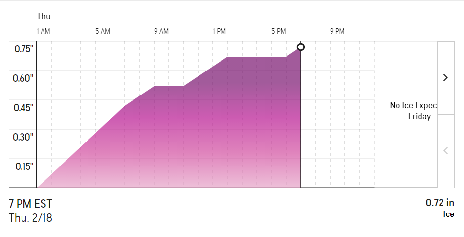
25 minutes ago, WeatherWeenie87 said:
WPC Freezing rain accum map

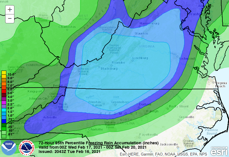
I like how their scale includes up to 10"+. It's like they're allowing for the possibility of a day after tomorrow thing
-
2
-
10
-
-
-
If you don't have generator, I would recommend going out and buying a camping stove. I think the ones that run on gasses other than propane can be used indoors if in a well ventilated area, but don't quote me on that.
-
1
-
-
Just now, PantherJustin said:
I’ve wondered I’ve never seen the FRAM model
FRAM isn't a model, it's an algorithm that calculated true accrual of ice. It tends to be much more conservative than just straight accumulation maps.This is why it's concerning, because it will account for the portion of the rain that's just runoff.
-
3
-
-
-
15 minutes ago, BullCityWx said:
The RDPS(think RGEM HRRR) is super cold at the surface. As cold or colder than the RGEM.
Drops .5" of precip in three hours with temps at 27 in grrensboro
-
7 minutes ago, NorthHillsWx said:
Man, 850’s are an absolute torch on both NAM and GFS. With the lack of an apps runner, what is causing this surge? I think combined with heavier rates that leads to higher BL temps on some modeling as it eats into the wedge from above.
I dunno why. But wowzers. Those are some dynamics

-
I'm on mobile, but the RGEM is as classic an ice storm signal as it gets. Temps don't rise about 30 in the triad for almost the entire event and over 1.5" of precip.
The few factors working against significant icing: Rates are a bit heavier this go around and it will be fairly warm and sunny the day before. Also more of the precip will be during the day.


Mid to Long Term Discussion 2021
in Southeastern States
Posted
Big oof