

olafminesaw
-
Posts
3,052 -
Joined
-
Last visited
Content Type
Profiles
Blogs
Forums
American Weather
Media Demo
Store
Gallery
Posts posted by olafminesaw
-
-
BWI: 11.2"
DCA: 8"
IAD: 12 .8"
RIC: 5.4"
Tiebreaker SBY: 5"
-
53 minutes ago, goldsborosnow said:
Is there a way to tell how much ACE the regular names were responsible for vs how much the Greek names were responsible for?
So far:
101.7 for regular
72.7 greek
Got these from http://tropical.atmos.colostate.edu/Realtime/
-
 5
5
-
-
We seem to have landfall

-
Oof. Still stalled out too
-
 1
1
-
-
Is it possible that the reason Eta was weaker than satellite suggested because of how far south it is? I don't know much about the physics of hurricanes, but I ask because I was wondering if the coriolis effect only played a role in development or also in maintaining intensity
-
4 minutes ago, Windspeed said:
That last vortex message was a little concerning. Closed eyewall at 8nm. It's over a shallow shelf, not sure if upwelling or participitable cooling could bring down shallow SSTs fast, but it leaves the door open for some possible restrengthening if it lingers too long off the coast. Might just hold its own through landfall, but we'll have to see if the satellite presentation responds and the eye can clear out. New outer band could also reinstate another ERC just as well too.
Looks like maybe a bit of shear though, on the south side of the circulation? May prevent the eye from organizing very fast. Motion definitely seems more south than west right now
-
Last minute change to 897 mb, 160 kts
-
Kinda terrifying tbh
-
6
-
-
The plane is making good time. Probably half an hour to go. I might be convinced to join team #sub900
-
913, 150 kts
-
I'm guessing it's around 140-150kts atm.

-
Honestly looks kinda like an ERC has not only begun, but is well on it's way to completion. Explains why the eye is getting larger but not clearing out.
-
1
-
-
-
looking like current trajectory would put the center of the eye of NO
-
A plane should be in the storm in about an hour.
Any idea why they aren't running nearly as many missions as some other hurricanes this year? Budget running low?
-
1
-
-
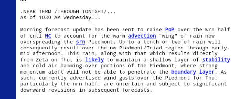
The CAD may limit the wind threat for the NC Piedmont:
-
1
-
-
Wowzers. Likely overdone. But the GFS doesn't overdo gusts to the same degree the Euro does

-
Pressure down to 979mb. Winds still lagging somewhat
-
10 minutes ago, NorthHillsWx said:
Zeta has developed an extremely impressive outflow pattern since last night. However, convection is struggling mightily near the core and a large moat has developed between the central convection and a cyclonically curved outer band. I believe we’ll see the outer band structure decay over the next 12 hours and an increase in convection over the center as that occurs. SST are sufficient and with the outflow pattern, I do expect strengthening to occur. However, the system took more of a hit over land than it seemed while over land. This spread out structure will take much longer to coalesce and see a quick uptick in intensity. I predict a slowly organizing system to peak and then stay at similar intensity through landfall. Probably on the order of 70-80kts. If this had a better structure I would be concerned of a stronger system but it will take considerable time to reorganize in its current state
I'm starting to see a pattern where for every hour a hurricane spends over land, it takes about 1 hour to reorganize (assuming good conditions). Zeta was over land for about 12 hours.
-
2
-
-
3 minutes ago, Windspeed said:36 minutes ago, dwagner88 said:These products are typically very overdone. That being said, the ECMFW and GFS both depict a significant inland wind event across central Alabama and Northern Georgia from Atlanta northwards. Essentially along and just north of the I-85 corridor. If you want to see fall leaves in the mountains, go today.
Could be pretty potent ET transition over land well inland. 80-90 kt low-level jet at 900 hPa. Just depends on how strong convection is on the eastern flank of the circulation to mix down gusts as it phases with the mid-level low.
The GFS brings 50-70 mph gusts up through north Georgia, upstate SC, and the western half of NC
-
1
-
-
Nasty for OKC

-
*for entertainment purposes only*
-
2
-
 3
3
-
-
 Pretty strong agreement
-
1 minute ago, Brian5671 said:
Climo
Speaking of which, the next couple years are going to be a dumpster fire as everyone forgets what climo is and expect major us landfalls all the time, when what we will get is fish fish fish
-
1
-
 1
1
-


Mid to Long Term Discussion 2020
in Southeastern States
Posted
Time to go full weenie?