

olafminesaw
-
Posts
3,759 -
Joined
-
Last visited
Content Type
Profiles
Blogs
Forums
American Weather
Media Demo
Store
Gallery
Posts posted by olafminesaw
-
-
-
29 minutes ago, NorthHillsWx said:
One of the wildest tornado videos in history was that Myrtle Beach tornado that developed along a sea breeze front and roared directly down the beach in front of the high rises for miles. I think that was EF-2. Coastal fronts 9 times out of 10 wreck havoc on storms as they approach the beach and almost always cause them to be undercut and become outflow dominant. However, violent tornadoes and outbreaks like yesterday are exceptionally rare and the setup for discrete super cells like we saw yesterday out in the clear rarely materializes in that area. Really was likely a historic day yesterday but thank the lord it hit some of the least populated areas in the southeast. A really really close call with Columbia as well.
I would imagine there are quite a few similarities to a typical Carolina Alley outbreak, just further south.
-
19 minutes ago, nwohweather said:
Not violent, it's pretty difficult. From Mothers Day to Labor Day we really take on a fully tropical climate which lacks the wind aloft in sea breeze thunderstorms to put down anything. Also most stronger lows do not affect us as they go poleward as deepening occurs out of OK/TX in the winter and stay to the west of the Apps. It's certainly rare to see things line up, but when it does you have ample moisture to bring those LCL's down like yesterday
I was able to find two cases:
Galveston:https://www.tornadotalk.com/galveston-tx-tornadoes-september-12-1961/
Georgia: https://www.weather.gov/chs/TornadoOutbreak-May2008
There's a possible third in Tampa but I can't seem to find any info on it (I'm not counting the 1966 long tracker as F4 damage for that one was more inland).
There are others that are more inland (one West of New Orleans) but I decided to research only truly coastal locations.
-
5 minutes ago, nwohweather said:
Heck of a day down here and really we lucked out. Due to the water table (whole place is a swamp) basements are not something common at all in this region. Thank God this didn't head to around Charleston, you have a metro area the size of Dayton with absolutely no basements. Really a worst case scenario for violent tornadoes
Is there any kind of precedent for violent tornadoes in coastal cities? I feel like they are extremely rare (the recent New Orleans tornado nearly meeting the criteria).
-
6 minutes ago, gtg947h said:
It's not over yet... another Enhanced area for today covering most of Georgia, Alabama, and eastern Tennessee
Covers a more populated region this time around, including Atlanta
-
The most classic a hook echo, supercell, cc combo I've seen east of the Appalachians. Holy cow that's not good
-
51 mph gust at GSO. Consistently gusting in the mid 40s with this slug of moisture
-
I've experienced more wimpy tropical storm warnings than what we've been seeing this morning (wind gust to 40 at GSO). Won't take much convection to mix 50-60 mph gusts to the surface. I'm not anticipating 60 +, but could be fun (although these high shear low CAPE squall lines always seem to be underwhelming)
-
As per usual at this range, some question as to whether discrete supercells will form ahead of the main line. Regardless, unusual to see the word "outbreak" this early in the SPC disco.
-
Looks like the only EF3+ tornado in New Orleans going back to 1980 was in 2017 (an EF3). That damage definitely looks like it could be in that territory.
-
 1
1
-
-
About as incredible of nighttime footage as I've seen
https://www.facebook.com/ScotPilieWx/videos/651457422801824/
-
13 minutes ago, Eskimo Joe said:
Looks like some gravity waves evident in east Mississippi ahead of the line? Might be an indication the atmosphere is primed for a decent tornadic event. Also surprised at the lack of posts for a D1 MOD. Is this not a popular subforum?
More discussion on the Central/Western Sub-forum. It's kinda awkwardly between subs, especially with not many posters in AL/MS
-
 1
1
-
-
-
This one must have taken some extra time to write
A northern-stream and southern-stream shortwave will phase over the MS Valley on Friday night, with an associated surface cyclone moving northeast from the Deep South, deepening to 990-995 mb by the time it reaches north-central NC early Saturday morning. Deep southerly flow from this system will help draw plenty of low-level moisture from the Atlantic, with PW values of 1.25-1.75 inches. Thus bands of WAA-induced showers will move in from the south on Friday evening and Friday night, when POPs increase to likely and then categorical over much of the area. Not expecting any thunder during this period given a complete lack of instability with a low-level inversion in place. However, this changes in the late overnight hours into early Saturday morning, when southerly low-level flow really starts to increase as the surface low approaches and deepens. Thus outside of the far NW, temperatures and dew points will start to rise through the 50s and even lower-to-mid-60s, with MLCAPE reaching as high as 300-500 J/kg. Meanwhile a squall line associated with a strong cold front will be moving through the area around 09z to 15z. While instability will not be too impressive due to the time of day and widespread precipitation, some damaging winds and isolated tornadoes are still possible with the squall line given the very strong low/mid level wind fields and rich low-level moisture. The one exception is across the Triad region, where the cold front should probably arrive early enough to shut off any instability and threat of storms. The most favorable location for severe weather is in the eastern Sandhills and southern Coastal Plain, which will have the longest opportunity for WAA and daytime heating before the cold front moves through. This is also where 0-1 km shear and 0-6 km shear look to be at least 40-50 kts and 60-80 kts, respectively, which is more than enough to support supercells and tornadoes. Thus the SPC has introduced an enhanced risk for severe storms in the far SE, and has expanded the slight risk to include the US-1 corridor and points east. The slower the frontal timing the better the severe threat as it would give these areas more time to destabilize. Total rainfall of around 0.75-1.25 inches is expected on average across central NC. This isn`t enough to cause any significant flooding concerns, but some localized urban and poor drainage flooding can`t be ruled out. Widespread precipitation will come to an end from west to east with the passage of the cold front on Saturday morning. However, our region will be in a strong pressure gradient between the rapidly- deepening 970-980 mb surface cyclone just off the coast New England and high pressure building over eastern TX and the lower MS Valley. Thus strong NW winds gusting as high as 30-40+ mph are expected during the day and into the evening. This will result in temperatures initially in the 50s and 60s early Friday morning falling into the 30s and 40s through the day. As the mid/upper trough swings through on Saturday afternoon, models show potential for a few wet snowflakes to fall across the NE Piedmont and especially the northern Coastal Plain, as temperatures aloft will be falling to well below freezing. However, with surface temperatures still above freezing during the afternoon and having been well above freezing over the past week, ground temperatures should be too warm for any accumulations to take place-
1
-
-
The hires NAM has temps falling from 52 at 5 am to 37 at 7 am. I'm suspicious that the cold will hang back, which will prevent all but a token flake or two.
Anything that does fall will be unlikely to stick due to our usual March factors that shall not be named. Still, a little white rain will be a welcome sight before spring comes out in full force
-
Some indications of a snowflake or two Saturday morning/midday for the western/northern Piedmont. The wind chill would make Saturday afternoon frigid by January standards.
-
Looking forward to next winter ready? CPC to probs to dash your hopes and dreams (ok, I realize this is meaningless)
-
49 minutes ago, Always in Zugzwang said:
I was thinking exactly the same thing. And it was a rather one-sided domestic political answer as well.
OK, stepping away from the political waters here, so as not to wade too much into that.
I found this video go be super helpful in understanding the situation. Covers everything but the ideological side of things
-
1
-
-
18 hours ago, mattie g said:
It would probably be easier to answer questions, if I'm honest. There's a ton to unpack and it's really tough to get my head around it all*. Feel free to throw them my way and I'll do my best. I'll also be honest and will tell you if I don't have the expertise / knowledge to weigh in.
I'm not actively involved in foreign or security policy or anything like that now, but I do think my experiences give me a decent perspective on what's going on and some of the language being used by Putin to justify the invasion.
* It's INSANE that we're even talking about a Russian invasion of Ukraine right now. Not that an invasion of a smaller country should be any different, but the unfortunately political reality is that it is. I recently saw some short clips of some of what's happening (nothing graphic), and it got me really unnerved.
I've seen a ton of different takes on what the true motive behind the invasion of Ukraine is. My current impression is it has mostly to do with distrust and resentment of the West as well as a desire to be taken seriously as a nation (which also looks back at the USSR's former "glory" and even beyond). What's your take on what motivates Putin's actions?
-
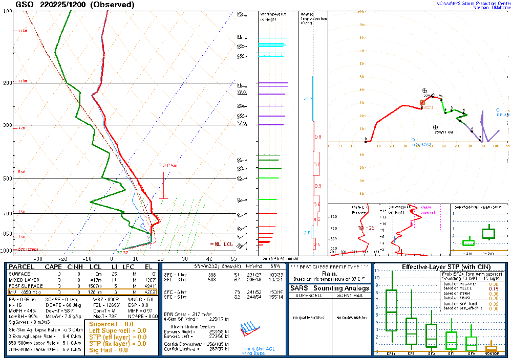
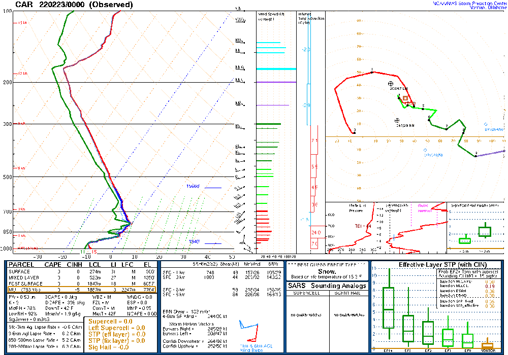
Rather impressive soundings last night and this morning
.thumb.gif.43af1e0f63033cdc918b8eea95a8f7c0.gif)
-
Wedge in all her Glory

-
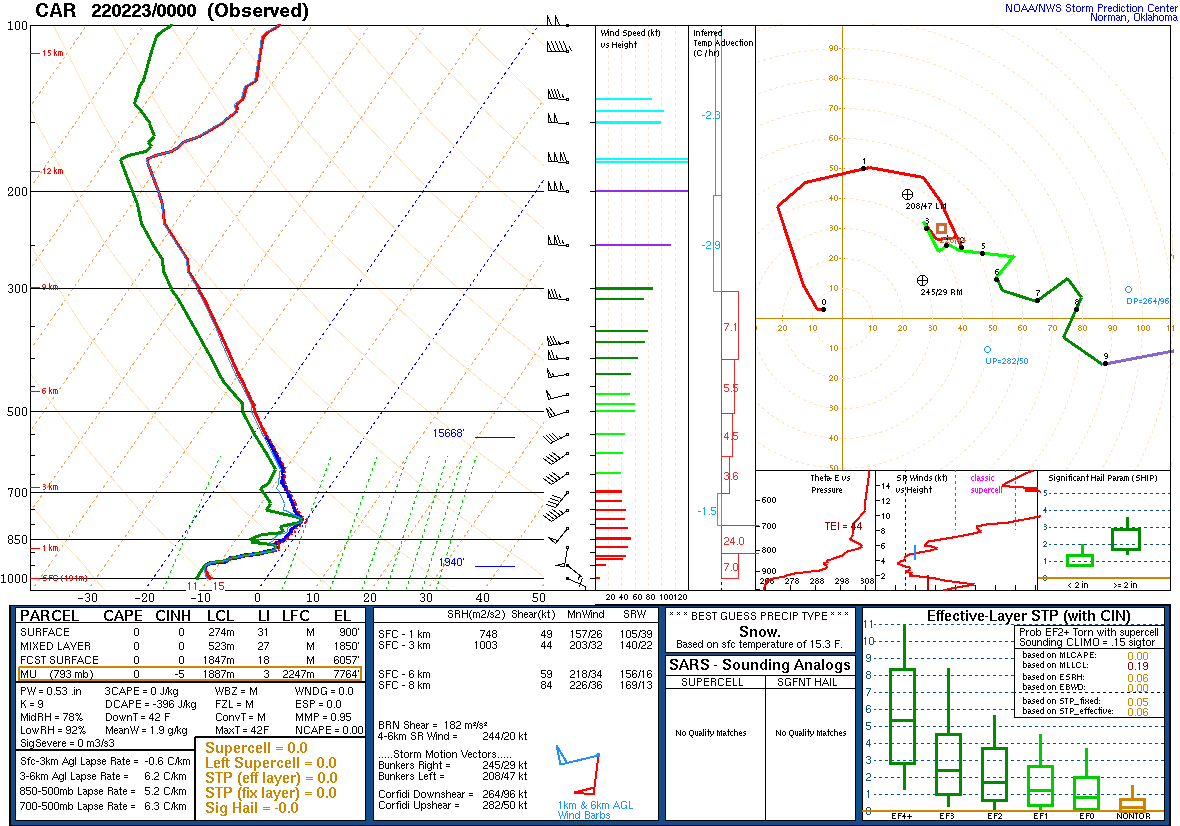
9 hours ago, WinstonSalemArlington said:
18 and sleet in Caribou is some warm nose
Yikes! They also reported 26 and zr two hours later and an hour after that 33 and heavy rain.The corresponding sounding at 0z.
-
1
-
-
I think we can officially declare winter over after Sunday. No signs of cold before the 10th, at which point we enter really rare territory for snow
-
3
-
-
Too progressive and leaves the energy behind. Too much ridging out West. Need more amplitude with the wave and for everything to slow down enough to get separation from the wave before it


.gif.804efd759d7b8d67f4b4bc0072ad284b.gif)


Mid to Long Range Discussion ~ 2022
in Southeastern States
Posted
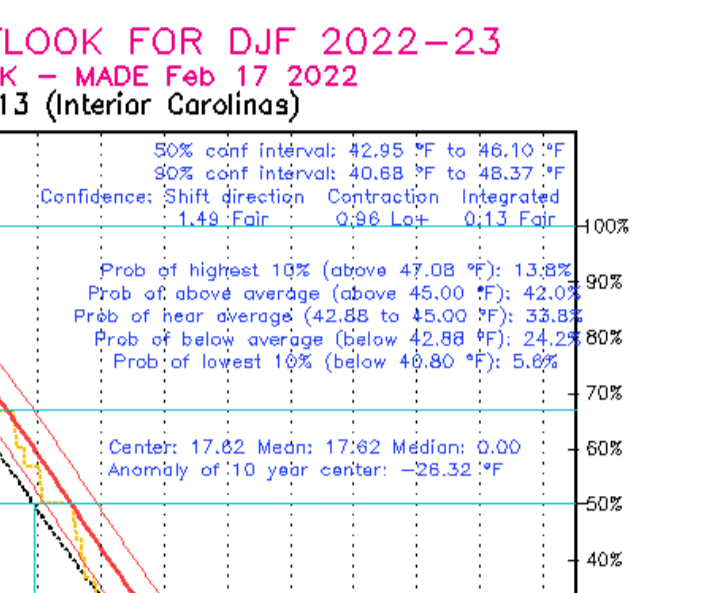
Probabilities for the Piedmont: