

olafminesaw
-
Posts
3,054 -
Joined
-
Last visited
Content Type
Profiles
Blogs
Forums
American Weather
Media Demo
Store
Gallery
Posts posted by olafminesaw
-
-
28 minutes ago, NJwx85 said:
It doesn't seem like a big deal because the system is already too far gone at this point, but that's a shift on day 5 of over 500 miles. It's like shifting from Charleston to Miami in a single run.

To me it just means that soon to be Karen (presumably) has a very high likelihood of finding a weakness in the ridge
-
1 minute ago, WxWatcher007 said:
On the other hand, it’s very close to land. Idk.
Couldn't it conceivably continue to organize over land for a bit?
-
I'm surprised there's not more talk about this

-
19 minutes ago, WinterWolf said:
That was my first thought too...wow that looks eerily similar.
Sandy was captured by a trough, the Euro has it pushed inland by a strong high. Kinda similar track, totally different synoptics.
-
6 minutes ago, cptcatz said:
The 18z GFS decimates the entire state of Florida
Kinda unrealistic how quick it recovers after being swallowed up by Hispanola, but...
-
 1
1
-
-
-
2 minutes ago, Rjay said:
That altered cone is hilarious though.
The wild speculation around the office is better analysis. He sure does know how to use the least amount of info to draw the most ambitious conclusions.
-
Ahh, this thread just wouldn't be complete without political nonsense.
-
 2
2
-
-
2 hours ago, downeastnc said:
NAM 3K says hold on to your hats.....this is gonna be overdone but not sure by how much, if the storm is well organized and large it might not be that far off....

Not entirely unrealistic I don't think, at least near the coast, if it does in fact manage to hug the coast for a while.
-
1
-
-
Can we have an aftermath thread, to keep separate from banter?
-
If Matthew and Irma had a baby, it would be this storm.
-
14 minutes ago, the ghost of leroy said:
It’s rapidly intensifying and feeling the dry air and shear on both of its eyewalls. Super epic.
Meteorology 101: What doesn't kill it makes it stronger
-
1
-
-
Pretty good winds with the main line. I would guess mid 50s and got some long sustained gusts. On the south side of Greensboro.
I was stupid enough to leave my windows cracked even though I knew the rain was coming. Parked perpendicular to the winds too.

-
A steady downpour, GSO reported .96" in the past hour
-
21 minutes ago, griteater said:
Lots of lightning firing in those cells from Athens to Augusta - moving NNE
It's starting to get that firehose look, aimed straight at the mountains. Meanwhile, further north we've been getting on and off sun with CAPE rising. I'm dubious the northern Piedmont will be the focus for the heavy rainfall until perhaps later tonight, but any slow moving cells will have some fuel to work with.
-
1
-
-
22 minutes ago, strongwxnc said:
I’ll be in black mountain this weekend running the black mountain monster 24hour race. Looks to be wet!
.Hope you're a good swimmer
-
1
-
-
No drought concerns heading into the start of Summer
-
2
-
-
19 minutes ago, kvegas-wx said:
Line that just went through the Triad was amping up the whole time. Very heavy rain, maybe some pea size hail and some solid lighting activity. Radar is loaded. Wouldnt want to be in central and eastern NC today if all of these cells start going severe.
It weakened quite a bit. Must have hit a pocket of higher instability earlier
-
9 hours ago, Iceagewhereartthou said:
CAE had 5 days of 100 or higher with a 99 wedged in between. Ouch.
While GSP did not see the brunt of it, it was plenty hot there too. 7 straight days with highs b/w 94-96; that's probably the hottest week I can ever remember for May, unless the one in the mid 90s was close.
Even AVL reached 90-91 four days with three more either 88 or 89.
That's a new record for CAE, beating the previous record of 3 days of 100+ in 1953. And the second most number of 90+ days on record for AVL.
Greensboro's 7 days of 90+ fell three days short of the record, as did Raleigh's 8 days
-
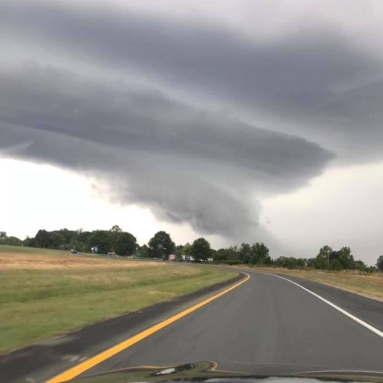
Found this on the Greensboro subreddit taken on Hope St. Road:
-
2
-
-
-
A lovely time for my car's AC to go out...
-
6 minutes ago, Crazieman said:
SPC calling moderate risk again, TX panhandle.
I can't remember a time they've issued moderate three days in a row.
-


Major Hurricane Lorenzo
in Tropical Headquarters
Posted
The eye's still a bit ragged, otherwise I'd think cat 5 for sure