

olafminesaw
-
Posts
3,052 -
Joined
-
Last visited
Content Type
Profiles
Blogs
Forums
American Weather
Media Demo
Store
Gallery
Posts posted by olafminesaw
-
-
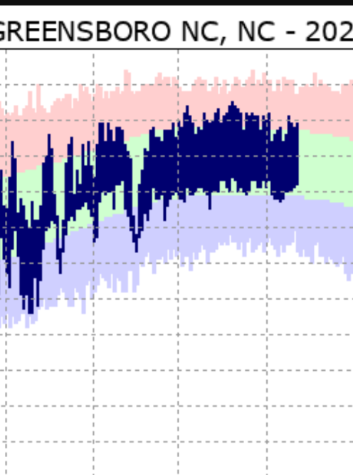
It's remarkable how near average the temps have remained the past couple months in Greensboro
-
27 minutes ago, Windspeed said:
So far 2020 has been gangbusters. We're low on ACE considering number of named storms due to no majors or long-tracking storms with persistent hurricane intensity, but that is likely to change in a couple of weeks regardless of short-term development. We are still way ahead on ACE as well versus climatological mean.
Meanwhile the Wpac, which has hit peak climo, had been completely quiet. It must be near record low at the moment.
Does anyone know if the two basins often have an inverse correlation?
-
Seems in the Triad we'll get stuck between any PRE to our. NW and he bulk of the precip to the east. I wanted a good rain storm...oh well.
-
2 hours ago, Eskimo Joe said:
The one thing about LWX that I cannot understand is they will hand out SVRs and winter products like candy during marginal events, but are super stingy on heat products.
Probably because it tends to reach criteria a lot for the region

-
 1
1
-
-
Today or tomorrow might be our first 90 degree day in Greensboro, which would be our fourth latest on record behind:
July 2nd (1983)
July 5th (2017)
July 18th (1972)
-
2 minutes ago, NorthHillsWx said:
70% rain chances changed to 30% real quick today
I have a feeling that's exactly how this summer is going to go
-
Two days in a row, GSO hit 89. Still no 90 degree day. Saturday could be our last chance to hit the mark until around June 20th, which would be rather unusual.
-
-
-
-
They need to work on their map legibility
-
The hires models are showing a band setting up and training over one area somewhere in the Piedmont. Wherever it gets stuck is going to get pounded with at least 2-4" through tommorow morning. As of now concensus seems to put the bullseye somewhere in between the Triad and Triangle up to around Roanoke
-
Might as well make a thread. Get your paddle.
-
I'm surprised RAH hasn't issued a FFW yet.
The NAM would bring storm totals to the 6-8" mark
-
As of now it looks like Thusday morning is when the worst of it will hit for the Piedmont, at least in terms of flooding concerns
-
-
Looking from the outside in at this possibly historic storm, I've never seen such a series of weenie runs from the NAM, in terms of low probability outcomes. Of course the NAM is probably wrong, but noon Saturday:

-
44 minutes ago, DanLarsen34 said:
Dixie Alley is tornado alley at this point.
Yup

-
1 hour ago, Bob's Burgers said:

Interesting how they cluster in a line from Texas to South Carolina
-
It would seem a line of rain/snow showers could make it over the mountains tommorow midday/afternoon, and perhaps a second wave in the evening. Pretty good agreement from the hires models, but probably too warm for anything that does come through to stick. But I know how stingy the mountains are, so probably only light precip, if that.
-
1 minute ago, Iceagewhereartthou said:
Yeah I don't get the lack of moisture complaints. I haven't seen any sleet, and cold is certainly an issue, but there's plenty of precip. For those lucky enough to have the cold, you'll be fine.
I think it's mainly driven by watching the NAM nail us run after run. Did a lot to raise expectations. The reality is this has looked like a 1-3" event with some upside potential since Tuesday morning
-
2
-
 1
1
-
 1
1
-
-
Radar is starting to fill the dry slot (albeit slowly). I think we can definitely pull off 1-2", 3" if the costal component gets going early enough
-
2
-
-
The wetter HRRR and RGEM have solid precip in the Triad by 12, while the NAM holds back for a few more hours. We shall see which is right, although nothing building on radar just yet
-
Good tends on the HRRR in terms of QPF for N and W, FWIW
-
2
-
1
-


The "Double Trouble" Banter Thread
in Tropical Headquarters
Posted
Ruh roh