

olafminesaw
-
Posts
3,052 -
Joined
-
Last visited
Content Type
Profiles
Blogs
Forums
American Weather
Media Demo
Store
Gallery
Posts posted by olafminesaw
-
-
Seems the ICON likes to go a little too extreme with CAD. A bias to look for in the future. It's really backed off on the weekend, and now it's showing this madness
-
Seems reasonable for threat zone. Also uhh....yeah. I think virginia beach is getting, well... you know.
-
1 minute ago, BornAgain13 said:
UK looks good up this way , not sure how much of the snow is actually ICE on their snow map though
Probably primarily sleet/zr. Looks similar to the ICON, just a good bit north.
-
22 minutes ago, BullCityWx said:
Also tries hard to have mostly sleet N&W of 85 in the triad and triangle.
Seems like it would be a mix of freezing drizzle and any heavier precip would be sleet based on soundings.
-
 1
1
-
-
3 minutes ago, BullCityWx said:
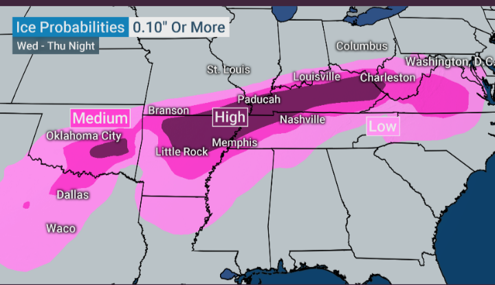
It looks like the NAM is showing a multi-day ice event.
It's been picking up on that feature behind the initial push of moisture. Could lead to a decent amount of icing, as the precip isn't particularly heavy.
-
Ice looks epic on the models, but in reality is kinda disappointing, even when it's good.
-
2 minutes ago, BornAgain13 said:
ICE STORM beginning per NAM , N NC S VA @ 78
Not typical of ice storms to start as plain rain and then drop below freezing (31 in the triad). Part of it's the dry airmass, but still...
-
Hear a fair bit of sleet now in Greensboro. Coming down pretty good. Officially a car topper
-
Trends

-
Is there a way I can invest in a hedge fund for snowy model solutions? Seems like shorting snowfall outputs would be pretty lucrative.
There's always next week...
-
2
-
-
Playing it close
.thumb.png.34050a69982575891280ad53cde834e5.png)
-
Not that it matters, but I can't make sense of Raleigh's forecast. All rain before 4 am then rain/snow. It's totally backwards (although some models do show a bit of back-end snow)
-
1 minute ago, BornAgain13 said:
Yeah thats the only down side to the BOOM. , is it might be better up this way but not good for most of the forum... maybe their can be a middle ground for everyone
If the NAM's temp profiles are right, could be a raging sleet storm for many, even with some additional amplification (probably too cold but still) another issue with a more amplified storm in addition to WAA, is a dry slot south of the axis of heavy precip
-
Classic sleet sounding. One reason I lean towards more of a moderate impact event is a trend towards colder in the lower levels.
.thumb.png.71a059acb589b6ffc8b88187cd214c7b.png)
-
Nice front end thump on the NAM. .4" qpf in 6 hrs. Temps near freezing. Nice dynamics. A little further north with the banding than I feel comfortable with, but I'd like to lock it in now
-
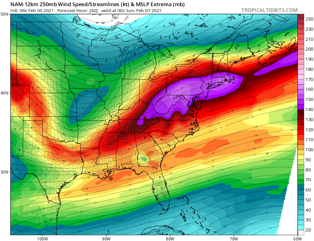
I'm not well versed on jet streaks, but I think this is a good look for the piedmont?

-
I can totally understand RAH's hesitancy. Even the 6z NAM never gets temps below freezing. If the NAM plays out as depicted, we certainly would get a few inches accumulation, but I could also easily see a relatively quick changeover to rain or flipping back and forth depending on rates
-
1
-
-
The storm seems to have speed up by almost 6 hours since yesterday afternoon. Snow should be wrapping up by around 8 am at the latest in the triad (earlier if we flip to rain).
-
1
-
-
Not a whole lot of cold air to work with on the Euro, temps in the mid-30s and some WAA leads to a changeover to sleet thwn rain. Healthy moisture though.
-
14 minutes ago, PantherJustin said:
Exactly, not to be rude.... but I’d take a 1-2” event and Be ecstatic I didn’t get that last year. And haven’t had anything over 1” since DEC 18 we get a couple good medium range runs and think we’re the Northeast or something lmao
Fair enough. Maybe it's because I've only lives in the south a few years (and have lucked out on several quality storms in that time), but I would much rather one cold 2" storm that sticks to everything than five 1" grass toppers. But I digress...
-
I'm not too enthused about the Saturday night storm. Looks like another sloppy coating to an inch type deal. Overnight too, with not a lot of upside.
-
The para GFS brings 1-3" to northern NC and southern VA Sunday. Room for improvement too.
-
1
-
-
2 minutes ago, Blue_Ridge_Escarpment said:
Icon followed suit
Radically different look though. Much more northern stream and so a stronger storm on the Icon. It gets organized faster, so the cold is able to wrap into the storm compared with other guidence. The NAM, on the other hand, keeps the two pieces separate.
-
7 minutes ago, ILMRoss said:
Lmao, I applaud the end of the 00z EURO for basically showing December 1989 part two at the end of the run, an event so near and dear to my heart that the date is my phone's lock code. I mean that with no hyperbole- it's basically its synoptic twin. Guys, i don't know if the threats in the next couple of days will pan out, but have solace knowing that this window probably isn't closing anytime soon.
Mid 20s and pounding snow in the middle of the day in south georgia. Don't see that every century. Can't imagine what that would yield up this way if the southern stream kicked into gear at the right time

.png.d90dea32d3eb6041988f69650c0cf30c.png)
.png.df95aa3d1dbd2a5528a2f137f0ca0a79.png)
Mid to Long Term Discussion 2021
in Southeastern States
Posted
What happened with this weekend's system is notable, in that it did make significant steps colder. Keep in mind the significant shifts that have taken place within 3 days. Doesn't mean this one will turn out moving towards wintry, but an apps runner isn't set in stone, and even if it is impacts before flipping to rain could be significant. I've experienced all frozen storms with a low tracking to my west before (this was in virginia, so a little easier, but still...)