

olafminesaw
-
Posts
3,060 -
Joined
-
Last visited
Content Type
Profiles
Blogs
Forums
American Weather
Media Demo
Store
Gallery
Posts posted by olafminesaw
-
-
It's great that the majority of the heavy precip will be falling during the daytime.
-
The SREF is an awful model. Really Useless. Worse than useless.
-
 1
1
-
-
11 minutes ago, Lookout said:
I was quite surprised the nam's profiles were dismissed as i'm sure many were because of that. Interesting decision.
i love how he has athens being marked in elbert county instead of where it's really at, clarke.
He's not exactly known for his attention to detail.
-
Bullish as always

-
6
-
-
7 minutes ago, griteater said:
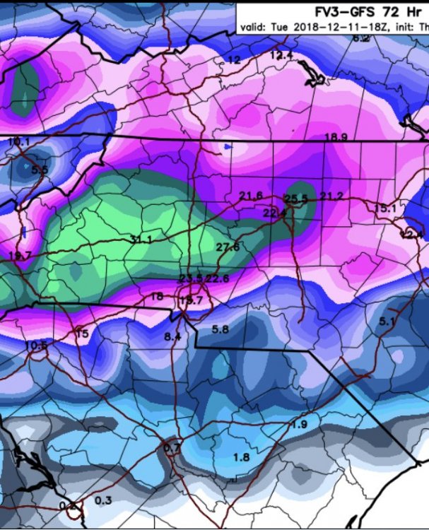
18z Euro compared to 12z was similar overall with temperatures. It brings the 850 0 deg back to just east of the NC Mtns during, say, the 2nd half of the heavy precip portion of the storm. It was wetter this run thru NC where there is a large area of at least 2 inches liquid. Here are the last 4 runs of total precip for the storm to Monday morning (12z Mon)
 Just now, HKY1894 said:
QPF seems to be on an upward trend since last nights 0z run on many models specfically on FV3 and euro
You can see how the precip gets enhanced as it hits the wall. It will be interesting to see where banding sets up, because wherever the jackpot zone is East of the Mountains, will be sitting under a heavy band for a while. My guess would be up near the VA border.
-
1
-
-
17 minutes ago, Poimen said:
This is almost comical. Close in:
It's all like... Come hither with the finger over Greensboro
-
1
-
 1
1
-
-
More than enough to digest while we wait for the 0z party to start here:
-
1
-
 3
3
-
-
1 minute ago, BornAgain13 said:
Out of everything I've seen so far on the 12z Data, what concerns me the most is the reduction in the GEFS
I wouldn't use ensembles to nail down QPF specifics. They're more for seeing track shifts and giving a general idea of where the jackpot will be
-
-
1 minute ago, strongwxnc said:
No doubt! Looks suspect..
.The hour 84 NAM looking suspect?? No.... Couldn't.
-
1
-
-
-
4 minutes ago, WidreMann said:
And yet we've seen it happen even within recent years. Can the satellites do as good a job as soundings
I would think you'd need data to make a claim one way or the other. Just because big model adjustments happen, doesn't mean you know why.
-
Edit: That wasn't all

-
4
-
1
-
2
-
-
Warm nose, trying it's darndest:

-
7 minutes ago, Queencitywx said:
Can anyone ever remember GSP using the word generational to describe any potential event? I surely can’t.
Generational or cold rain for the Triad? Maybe the offices should, like, talk to each other every once in a while.
-
2
-
1
-
-
2 minutes ago, sarcean said:
Every model is saying RAH is being too conservative, this storm is REALLY going to catch some people by surprise. Guess they don't care about calling it safe since the event is on a weekend?
IDK, The Weather Channel has been all in for a while, that usually gets the hype machine rolling
-
Don't look at the precipitation shield when comparing runs, people. Look at the MSLP and 500 mb charts.
-
1
-
1
-
-
This will be one of the longest duration storms I've experienced, around 36 hours of precip.
-
The GFS just NAMed us.
-
4
-
-
Notably lower DPs at hour 72
-
Just now, Orangeburgwx said:
66
1037mb HP centered over South Bend, Indiana
Seems to be running out ahead of the LP some, with the LP hanging back a bit more.
-
6 minutes ago, Buddy1987 said:
This is gold guys! ORH Wxman is amazing with this stuff when I lived up in the northeast still. Here’s the discussion:
This makes so much sense - see below, I guess all options are open.
Maybe at long leads we expect too much from the models, even in this day and age IMHO.
I brought this over from the New England forum, thanks @ORH_wxman .
<
The primary northern stream shortwave that phases on the euro doesn't come onshore near Juneau AK until 00z Friday.
The kicker behind it doesn't come onshore until 12z Saturday in the PAC NW.
The Arctic shortwave from the PV lobe that contributes to Quebec confluence is still over the central Arctic Ocean. It reaches Hudson Bay on Saturday...prob doesn't get decent sampling until it is near there since northern NW territories and the Canadian archipelago isn't exactly a poster child for a dense obs network...and satellite isn't going to be great there either with the extreme cold.
Bottom line is that we have a lot of northern stream and Arctic jet shortwaves that will matter to this system that are more prone to large changes than usual due to their position. So don't be surprised to see large changes on some model guidance between now and Saturday. It doesn't mean the changes will always be good for us, but obviously we will want to see changes for a hit here.
Anecdotally, this reasoning seems to come up with every storm, and it doesn't seem like the wave(s) coming ashore leads to big model changes most of the time. Of course, we should expect changes, four days out anyway.
-
1
-
-
31 minutes ago, tazaroo said:
how were the 6z ensembles? I think there still relevant another day or so
The GEFS was a step South again. If the Euro makes a small adjustment south at 12z, I'd say the Triad is all systems go for a historic storm.
-
10 minutes ago, PackGrad05 said:
The strength of the CAD will be the one of the key players in this, the other being the mid-level warm air that will sneak in. This will not be correctly modeled until 24-48 hours before go time probably.
Once the 3km NAM is in range we'll have a better idea. It's usually spot on with precipitation type with wedges
-
 1
1
-


December 8-10, 2018 Winter Storm
in Southeastern States
Posted