

olafminesaw
-
Posts
4,505 -
Joined
-
Last visited
Content Type
Profiles
Blogs
Forums
American Weather
Media Demo
Store
Gallery
Posts posted by olafminesaw
-
-
A work of art this one.
-
 4
4
-
 1
1
-
-
1 hour ago, wncsnow said:
F3 tornadoes in NC in July have to be really rare right? And probably even more so without a tropical system.
https://mrcc.purdue.edu/gismaps/cntytorn#
Seems to be the first time (unless maybe that fishy looking one right on the border)
-
From the live stream survey cam

-
-
4 minutes ago, NorthHillsWx said:
WRAL said there are reports of injuries coming out now. Hope everyone was OK. That looked very bad with the debris ball holding together so long.
Fortunately it mostly passed through farmland. Brattleboro (population ~500) may have taken a direct hit though.
-
11 minutes ago, NorthHillsWx said:
Wow at the current structure of that supercell!!! Confirmed tornado on the ground. Did not expect that today!
Wow!
-
Also...a friendly reminder to change out your HVAC filters. They're probably pretty gross!
-
I was surprised to wake up to a very smokey morning. Definitely one of the smokiest days yet, and the HRRR seems to back this up. Is anyone in Georgia experiencing particularly dense smoke?

-
1
-
-
15 hours ago, so_whats_happening said:
So how often do we see the potential of a system lasting not only to Hawaii ( I feel like this is a 1 in 5 year type of thing for Hawaii) but also going even into the WPAC?
I count only three - Ruth (1965), Winona (1989), & Ruth (1994). This is counting storms that passed within 100 miles of HI, & is inexact based on the crossover longitude as the NOAA doesn't display them. Winona is perhaps the most impressive in that it formed East of Hawaii and struck the Philippines as a tropical depression.
-
1
-
-
I'll just say, I wouldn't be standing that close

-
3
-
-
Pretty awesome outflow boundary!

-
2
-
-
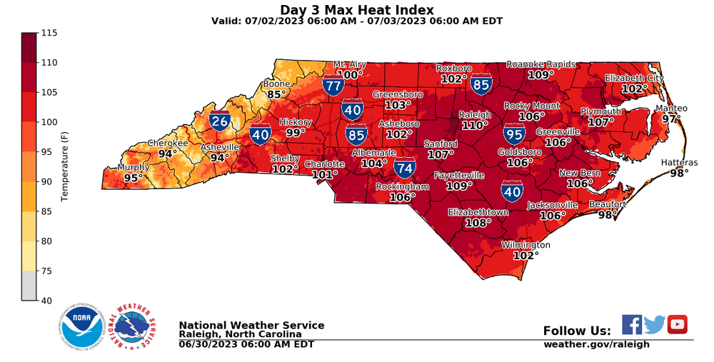
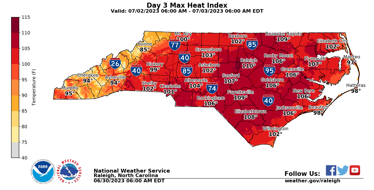
Sunday looking not only hot but also sticky. A rude awakening from a nice start to summer
-
 4
4
-
-
5 minutes ago, WinstonSalemArlington said:
I was just looking at this! These things are so hard to predict. They almost always fizzle once they hit the mountains and we get the scraps. But we are in an interesting spot just on the northern edge of the heat dome.
-
3
-
-
-
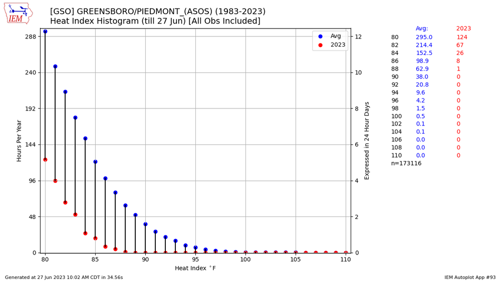
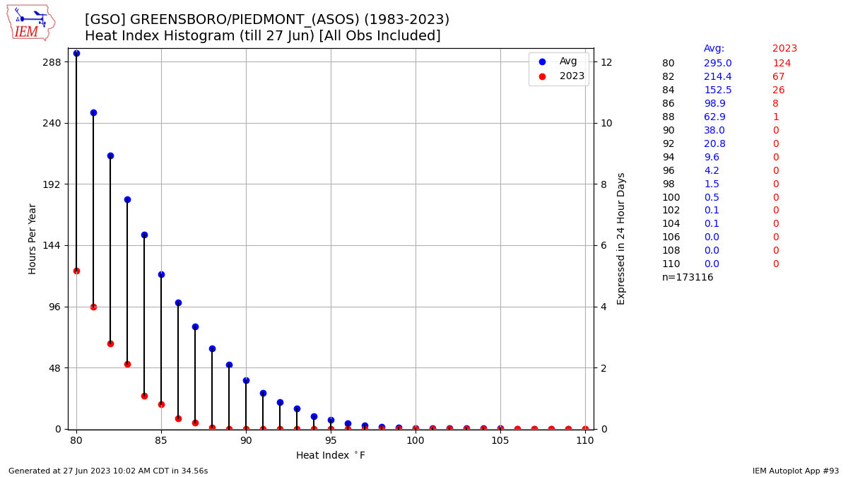
Another way to measure our cool start to the warm months:
-
7
-
-
At GSO, the percentage of years in which the first 90 degree day falls in each month are as follows:
March:1.7%
April: 18.6%
May: 45.8%
June: 30.5%
July: 3.4% (4 years out of 118)
Funnily enough, 2 out of the 4 years that made it to July were 2017 & 2020, and we haven't had a March or April date since 2006.
It's going to be really close to making it to July, with a forecast high of 89 on Friday.
-
2
-
-
29 minutes ago, Windspeed said:
Spaghetti plots going to be messy! May have to move away from showing the individual members.
-
I think that cell moving over North Wilkesboro is going to be the one to watch for the Triad. Hard to say if there will be more spread between cells as the HRRR depicts or if it will eventually form a fragmented line like the hires NAM.
-
23 minutes ago, eyewall said:
I am waiting to see if any discretes pop off the lee trough before working back toward the Triangle
Going to be a couple more hours until storms initiate per the HRRR. Still a weak cap per the meso analysis, although eroded significantly since this morning.
-
26 minutes ago, kvegas-wx said:
Man I dont want to see large hail. Some of the videos from AR, MS, TX, CO have me spooked! And I hate to see my hard work on the crops this year go to waste.
Sun is already bright here in the Triad.
FWIW, I think the latest SPC discussion is a lot less enthusiastic about a higher end threat. Seems like CAPE values are lagging a bit and CAMS have less impressive parameters. Might be the sweet spot where we get some fun storms without having to worry too much about damage.
-
17 minutes ago, wncsnow said:
They are but will it give the atmosphere time to juice back up? It can cap things.
Most heating will occur after 10 am anyway, with solar noon around 1:15. Lack of shear seems to be the biggest inhibitor out that way.
-
21 minutes ago, wncsnow said:
I think this mornings MCS will really limit things west of 77. Not that it's the prime spot anyways.
Actually I think the opposite, cloud cover will linger East of 77, through around lunchtime for the triad (per the HRRR) that may limit CAPE somewhat, but areas west of 77 are about to get full sun.
-
59 minutes ago, eyewall said:
I plan on headed out toward the Triad and points west to see if I can catch some discretes before upscale growth occurs.
SPC is definitely highlighting the hail threat, citing the potential for isolated very large hail. The last hatched hail event from SPC was May 23, 2014.
-
 1
1
-
-
1 hour ago, eyewall said:
He then said it may be due to moth/insect damage.
This makes more sense. Cool temps don't prevent foliage. It would have to be consistently dropping below freezing at night for temps to be the cause
-
2
-


WPAC, Indian Ocean, and Southern Hemisphere Tropical Cyclones
in Tropical Headquarters
Posted
I nominate this one for strangest looking cyclone of the year