

Typhoon Tip
-
Posts
44,568 -
Joined
-
Last visited
Content Type
Profiles
Blogs
Forums
American Weather
Media Demo
Store
Gallery
Everything posted by Typhoon Tip
-
I'm seeing that everywhere. Acton, Hudson ... over here at the Oxbow ob and up in Groton about 4 clicks N of me, all over 96 out of nowhere. Shirley ob is 94 .. I'm surrounded by big heat numbers now. The home sites less than a 1/2 mi away are all 94 to 97.
-
Yeah, I don't have an oil option here. Not sure what the comparison would be. Part of problem with oil is the carbon footprint. My aim after consult with the install engineer was that using power from solar... even if it still needs to be supplemented by the NGRID ( which I call Ngrip or nut grip.. ) would be 'doing what I can' ... and not purely dumping C02 into a system already force fed. So, together with lowering demand by a much more efficient compressor (mini splits) ..etc I'm not part of the meal, just crumbs.
-
actually the water temperature in the harbor's up to 63 and change... and p-town out at the tip of the cape is 87 so - heh
-
LOL I was just looking at that. wtf chuck.
-
Logan's about to drop. They're around to the SE ... meager, only 10kts, but the Harbor being 59 F in the contact layer probably doesn't allow them to just sit at 90 with that wind direction. Question is, is the shed a few do they get 'em back around 6:15 with the late west city fart
-
93/72
-
Yeah to be fair ... my property is small. My square roof space is not aplenty. But, my plan was to replace these hugely outmoded cash pig base board electric resisters with a heat compressor sys. These mini splits have been divine. And they're about 8% of the electrical use compared to those base board runners. Resister are just money eaters. I also updated all the windows in the house. Between these moves, and the panels, which I feel could have been better with one more, I am paying substantially less. SO not a complete failure. But I just feel they edged my sys in their favor - which is frustrating. It's supposed to be in my favor, and in favor of being responsible to the bigger problem facing everyone ...etc
-
no...
-
I'm not happy. I mean... I take some ethical value away for helping by trying to go green where I can, but humanity is completely and utterly fucked if they think they can solve anthropomorphically forced GW by means of capitalism and profit mongering - seeing a solution through a lens of greed. Good luck. And that is what this whole solar wave of install marketed as sistering to the grid bullshit is being exposed as. I was actually gapped by my company, which filed for bankruptcy and doesn't even exist anymore. I got a mailers ... I think some other outfit has absorbed them - but my electric bills were cut down so I'm willing to wait on investigation until I get these other home improvement scheduled projects completed - new kitchens make solar corruption look like a reach around at a Asian massage parlor but that's a different thing. Anyway, there's clearly enough room up on that roof for another panel but they held back claiming some bs about them needed 3.5 feet of distance that I don't see on any other house down the street - so frankly am suss. If I had that panel, I might not be paying as much. I call that 'gapping' haha. You know ... a digression here, but that is what is a part of this whole Disclosure thing is about? There's this ontological shock aspect about it, and the idea there is that the baser commodity that is the soil that all economic branches grow from, is in jeopardy because there is this shadow corporate-governance lording over technology that could provide free energy at the individual controls. Such a reality would completely freeze the gears of economics. Oil becomes obsolete as a energy mechanism... solar? Gone. Wind and renewables et al, albeit virtuous and perhaps even morally more sound than burning fossil fuels which are definitely a problem... all of it... the whole conflict and any economy that is rooted in oil at all. Gone. Here's the sociological problem with that - which is very real, btw. Economy is what allows societies to function 'over the horizons' It's the unfailing faith in the value of the dollar ( or whatever native form of currency). If zero-point energy ( being able to tap into the 10 e19th eV vacuum energy of the cosmos), and negative gravity propulsion systems ... the disruption to social order really is an ontological a-bomb.
-
The NAM MOS is trying to Charlie Brown the bigger numbers on Friday. Not a lot but MET is just 95, BDL to MHT, which barely makes the 'big heat' cut. For three straight days and 18 consecutive cycles, we were plugging 100s - we'll see if this late change is supported in general. Looks like it's inserting spontaneously generating convective debris which cannot really be ruled out absolutely...
-
Occasional Thoughts on Climate Change
Typhoon Tip replied to donsutherland1's topic in Climate Change
https://phys.org/news/2026-07-world-oceans-june-eu.html -
91/71
-
Yeah...agreed. I wasn't interested in nailing down - per se - where it is we "actually" are... full disclosure ( there's alien technology being hid from us!!! repent repent) no but to be honest, I'm wondering if CR can be trusted or might have known this or that. I mean I don't know anymore. This f era of reality and civility ... it's got a problem. One that is almost as big as GW and it's entirely self-manifesting at species' level.
-
Occasional Thoughts on Climate Change
Typhoon Tip replied to donsutherland1's topic in Climate Change
See ...there are baseline flow constructs around the entire hemisphere that are geo-physically forced. Example, western North America. The Rockies cordillera extends from Alaska deep into and through Mexico, over the western continent. That imposes a backward exertion on the prevailing westerlies of the Northern Hemisphere. The flow is directed up and over the terrain. However, it takes longer to do so than the ~ 9 hour, time dependency of the Coriolis parameter at mid latitudes; in a reference frame that induces clockwise rotation, that force acts to turn the rising flow toward the left. This creates a subtle but significant background ridge signal that is always in place ... so long as there is always westerly prevailing flow. This is a baseline construct... This means that western N/A is favored to have heat before the eastern geographical regions of the continent. It is why the Gulf Coast can, though rarely ..., experience 0 F in the winter, despite the deep latitude. This geologic circumstance enhances cold potential and realizes a drive sending colder air mass from Canada that far S. So, with all that in mind ... since western N/A is prone to ridging, they are also favored to heat. It's like being born on second base for having wealth descendancy, and though daddy claims he didn't help his kids succeed, they still end up retiring somehow by 35. This happens all over the world, both hemispheres. There are geological regional circumstances 'built in' that favor cool vs warm, relative to the whole latitude in question and mean. And where ever is warm, there is a quicker and more frequent recurrence of heat. But here's the thing that makes this argumentative - but really shouldn't if one understands the "emergence" ... Because there are circulation changes occurring ..however subtle or gross, notwithstanding ... this may and probably does expose new routes for cool vs warm biases overall. Western Europe appears to be victim to this, as Saharan processed kinetic extreme air is being drawn up across the Iberian Peninsula ... where it can assault as far N as the UK and eventually Scandinavian latitudes. The UK is ~ to Calgary, Canada ... so we're seeing temps nearing 40 C ... that's a bit of an emergence considering the frequency uptick -
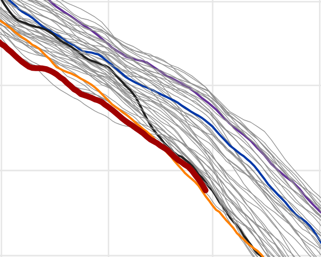
New record relative to what? Do you mean monthly or whole year? -I'm assuming month. This rusty dark curve doesn't look like 5th lowest, per date though. As far as yearly, given that steepness of this delta, that doesn't really infer it won't end up lower then every other member ( May-June-July), but obviously too early to get a fix on that. I don't know about Climate Reanalyzer accuracy and statistics therein ? but this is off their product fwiw. https://climatereanalyzer.org/clim/seaice_daily/?nhsh=nh
-
What source has 97 ?
-
Little bit of tree rustling and WNW breeze here. AWT, less cloud has resulted. Some up over SE NH but that's got a short lease on life I presume. Open sky heating here now. 85/71, up 9 in the last 1.5 hours. We'll see how '10 after 10' works out -
-
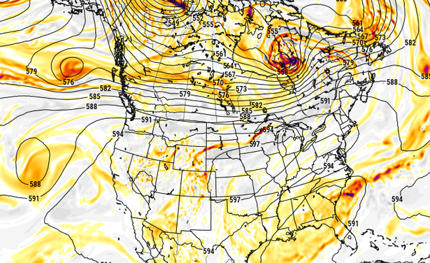
Nasty heat at the end of the Euro run (inferred) ... This was a purely SW lava puke that gets trapped over Chi-town ...with (probably in this kind of structure -) briefer inject through our region. But what's up with the over-zealous polar jet over top in Canada, huh. That's what keeps it brief for us - again ... if this depiction should prevail. which it won't but just sayn
-
op ed: You know ... as impressive as this three, maybe four day heat wave is.. I'm seeing subtleties in the guidance like they are tussling with a fast atmosphere offset. Typically, fast would negatively interfere with establishing resonant feedbacks - 'fast' sends disturbances into the engine that gums up the gears so to speak. In this case, linear forcing appears to be outweighing the non-linear mechanics (addition) to end up with a ridge surplus so some resonance is established. And there is a bit of non-linear neg interference in play ... evidenced not so much in the velocity of the flow, but by the rate of emergence and decay of pattern resonant features - which is a non-linear wave function. Faster life cycle means the pattern identities just can't seem to stay in place. This is something I've noticed frequently over recent decades - the emergence and fade life cycle of patterns occurring faster. I have conjectural ideas that some of the heat of CC is being absorbed and then converted and stored in the non-linear... which is then expressed by the energy required to move larger mass fields more frequently. It takes a lot of energy to change a pattern. A locked pattern is actually lower burden on global budget. But if you have negative EPO modes wildly transitioning to +EPO ... or more so, imagine an index as large as the PNA's domain space...etc, ... it costs to change the geometry of those mass fields. It's probably a good thing this dynamic is available otherwise, Antarctica might be half its size already and NYC's skyline would be a massive mooring harbor
-
It's actually not that convective element up there the NAM's using. It's actually just erupting a smattering of convection over and E of the Tug Hill country of N NYS, from diurnal instability, and then quasi converting the mass of it all into a very steeply arc tan angled right turn. I don't wanna trash the idea of some convective response today, entirely. The NAM used to be the ETA, and when it was the ETA, it was a superior ( lesser known) skilled tool for convective initiation. Basically, it's QPF smatters that we largely think of as noise tended to be eerily on point. I've never look to see if the NAM may have inherited that same trait - might be a testing op. Anyway, the broader synoptic consideration would argue suppression but this isn't absolute, either.
-
I could be wrong about this, but I doubt it means much down here. Perhaps NNE... but even there, the building heights that begin the main surge today, that's a neg interference. We'll see.
-
Yeah..that'll be a fun test tonight and more likely tomorrow night. Do the climo-favored warm nocturnal therm sites hold 80+ ? It seems to me that's a tough one. It happens from time to time, but it seems more usual to end up with a 5 minute, 78.4 or 79.4 blip on an otherwise 80 80 80 ... 80 score card.
-
no ... I think you're gonna find that no amount of distaste for heat, hot patterns, or those that like to rhetorically emphasize the significance of it... will change the reality that these are not very interfering, typical nocturnally enhance cloud types that are in the process ( like normal ...) of melting away with the diurnal processing of the sun - already evidence on high res sat. Heights are rising. That's intrinsically a DVM exertion. This will be a suppressive cloud factor as the day goes forward. Probably there will be mainly sunny conditions from 11 ... 11:30 on if not sooner. Should expect full realization of at least machine numbers. Probably a mean of 94 with outliers higher. Given the thrust of ridge bulging for the next 36 or so hours .. this will neg interfere with MCS mechanisms. I believe that MCS is not as much of a risk going forward until the other side, when we see the evolution of this ridge receding over the weekend. Perhaps Friday night?
-
I know this post is 9 hours old ... and what I'm about to wonder is incredibly tedious but, I always think of BOS as being climate tainted in these west wind dragon tongue patterns. Logan AP, being basically right outside the Boston urban anus, isn't likely to be cooler than BAF. Probably it would be more like OWD... But like ..who cares. right
-
90 was the high 88/66


