

Typhoon Tip
-
Posts
43,698 -
Joined
-
Last visited
Content Type
Profiles
Blogs
Forums
American Weather
Media Demo
Store
Gallery
Everything posted by Typhoon Tip
-
2026-2027 El Nino
Typhoon Tip replied to Stormchaserchuck1's topic in Weather Forecasting and Discussion
that was snark point... it takes a super dope phat bad ass nino to actually couple. -
2026-2027 El Nino
Typhoon Tip replied to Stormchaserchuck1's topic in Weather Forecasting and Discussion
maybe a super nino will finally couple to the mid latitudes more convincingly. -
ugly
-
Occasional Thoughts on Climate Change
Typhoon Tip replied to donsutherland1's topic in Climate Change
https://phys.org/news/2026-03-planet.html "The amount of heat trapped by Earth reached record levels in 2025, with the consequences of such warming feared to last for thousands of years, the UN warned Monday." -
I wouldn't trust warmth ... not that you are, just sayn'. Just an example, recall that 77 F two or so weeks back. It looked an awful lot like this 12z Euro run when it was 10 days out, too. It turned out to be one day's worth. Granted, it was a ginormous one day.. The thing with heat in the latter mids/ext ranges, it is about the least dependable anomaly of all them when it comes to early lead and staying power in the guidance. I'd put the infamous D9 Euro coastal bomb ahead of a warm pattern, particularly any lasting more than just an afternoon warm sector. They just get eaten at either end. Tweak the deep layer circulation mode a little and we BD and gobble 30 hours trying to erode it out on the front side...meanwhile, CC continues to instruct a faster than normal balanced geostrophic wind velocity problem which speeds things up 24 hours by the time it gets into short range. There's 2.5 days of your warm up, gone. Maybe not exactly but it's always something around here in the spring. Having said all that, there's a verifying tendency - so far - to revert back to an SPV gyrating around between Hudson Bay and Baffin Island... that's red flag for prick tease warm patterns.
-
Oh, it sounded at the time like people were comparing dick sizes on which region was dealing with the bigger cold vs heat. I probably didn't get the gist of the conversation right - which I'm not about to scroll back and review. lol. Standard deviation would settle it among scholars
-
It’s a means to determine which region is experiencing the greatest anomaly It’s the average of the deviation from the norm, which is climatology There is no flaw on that premise
-
There's scrutinizing data and findings, then there's false-equivalency in the application of information - most that are exposed/have access, do not know what to really do with that information. We live in an era now where commoners with limited or no academic exposure to the course work are being drowned in a tsunamis of information. However... without much or no academic/juried processing, there isn't much actual intelligence (how to reason with it) in how to use it.. Information alone does not make wisdom. Reality lurks in the latter. And it sure as shit does not make one righteous. Some percentage of those using the UHI argument are deniers that look like unbearable ignoramuses whenever they attempt to ply the argument. Some percentage just heard the argument at some point along the way and now sound byte it back at us. Neither of which realizes that CC is based upon a planetary integral that predates the construction of these urban engineering meccas. While no agency of adjudicated climate research either fails understanding, nor disputes that concrete and metal tends to augment temperature... that stuff is accounted for. There is no debate.
-
Just compare the standard deviations for the cold in Alaska, versus the heat in the southwest Whichever is of greater magnitude wins the debate
-
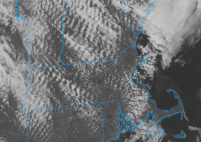
I have a small bit of Aspergers for shit like this ...whereby I remember things that are utterly useless haha... But it serves me once in while to see or sense patterns? I sense that you are probably located in a bad geographic circumstance in relation to elevation forcing - because every time you complain in that sort of same vein, it's a similar issue; this image looped shows that's actually trying to clear everywhere but those standing wave patterns are killing you
-
it's all or nothing and wholly sun dependent ... either it's sunny and 60, or clouds and wet at 37 seems the models are trying for another incremental step out around the 1st of the month. .. 10 days I guess of soothing cat paws to the napes in between fake warm coffee breaks.
-
It may end up just like today only 10° cold colder
-
We're just gonna have to get a +3SD ridge with SW flow punching underneath before these models finally, reluctantly stipulate to warming up N-E of the Mason Dixie ... That Euro run's an abomination. 85 in PHL and 35 in BOS and just holds like that for 4 days probably happens
-
I don't get it with these models sometimes ... why can't they just put up a few days that are like right now? 57, sunny, with just light breeze... You know, spring? wtf It's either got to be 6" of snow and hard nightly freezes, or 85 berzirko warmest ever
-
Something interesting went on with the NAM overnight. It seems to have been 'swapped out' for a warm result. The FOUS grids in this kind lee side polar air have been struggling to get above +2. Out of no where they are all popped to +6 to +10 in the T1 layer. Today is the Equinox, so if the switch to the summer algorithms is true it's as good a date as any to flip. Man, it is spectacular nape day. 53 full sun zip wind.
-
It's like 'Chuck NoMorris'
-
CNN confirms Chuck Morris passing fwiw
-
As an increasing frequency of observation, I argue that's been occurring less in summers over recent decade(s). There's a plausible reason for it too. I believe there is an emerging resonance feedback ( constructive interference) between the perennial rest state of the flow over the N/A continent, and the CC-related augmentation of heat potential. Combining those to background factors, favors in other words. Longer version: First, the perennial rest state pattern across N/A features a flat ridge tendency in the west that downstream flattens out to an impression of trough in the east, before the flow escapes out into the Atlantic. That means that at all times there is an exertion for ridging in the west, much to the chagrin of the "stop" and "shits" emoji wielding assholes on the forum. It's just that it's not 50/50. It's like a 42/58 thing heh. Second, warm air means higher heights. Now, when where there is heat in the W and SW, that means you have to combine those aspects - such that this results a resonant feedback ( constructive interference) between the fixed background state and the transience of the warm weather's wave function passing through. In short, the feed back enhances itself when that duality super-imposes ( synoptically). And since the back ground fixed exertion is ever leaving, nor is CC going the other way... As an after-note, this lends to the hypothesis that exaggerated ridges are sort of robbing eastern N/A from experiencing these synergistic heat bursts that have been occurring acround the world. Pac NW/June of 2021 ... the few times in NW Europe. Australian. SE Asia springs... etc. Those regions are not as "protected" by N/A built in circumstance of heat deflection. I think this is why NW NE and SE Canada have seen an uptick in the April and early May heat waves...because the DP side of all this hasn't seasonally moved into those regions, such that early heat slips that one mitigating factor, and only has to then overcome the background fixed state. Which the pattern does some times. I mean..this is not an absolute deliminator process at large scales - it's a 60/40 thing. And, by the time we get to mid/late June+ ... the CC -charged footprint teaming up with the background fix state, then adding DPs holding the temps down ... you know, it fits. Because we are contributing our warmth to the total warming pot in night times lows, which in the summer, are highly modulated by the DPs at that end of the diurnal temperature cycle. I think if there's ever a time when that 40 side of the 60/40 ( hypothetical ) delivers a shock and awe heat burst N-E of the Mason Dixie, it will probably be favored to occur in that mid May to mid June window. By July, we'll probably be limited to the 96/75 + upstream continent ozone reflecting particles type heat.
-
Those are the best kind. Single Supercell CB with nothing around it for 100 miles, carving a canyon 100 miles long
-
Occasional Thoughts on Climate Change
Typhoon Tip replied to donsutherland1's topic in Climate Change
C02 (and other green house gases) warms initially. This improves water evaporation ... Once in water vapor (H2O gas), it absorbs 8+ magnitudes more outgoing LWR than does C02. This secondarily triggers the system into a thermal state acceleration. Not sure what the C02 vs WV discussion y'all engagin' in, but that is the critical relationship. It's interesting as it has been calculated/shown that the oceans have absorbed ~ 90% of the d(T)/attributable heat of the total GW... Generate excerpt from Climate.gov and United Nations, "The oceans have absorbed about 90% of the excess heat generated by global warming, which is equivalent to approximately 23 zettajoules of heat energy in 2025 alone" (there are numerous other sources for the ocean absorption quotient in the GW total) It's a crucial machinery that frankly has saved ours, and countless other species, from an acceleration toward tipping points ( to put it nicely...). The ocean is the great climate regulator in the sense that because the atmosphere's in a perpetual quasi coupled state to the ocean, en masse it is held in check. Thus, the atmosphere can't really modulate too far way from the background thermal state of the oceans. This relationship may have been exemplified in 2023 https://phys.org/news/2025-09-ocean-carbon-ailing-absorption-marine.html. While the article doesn't directly discuss a plausible factor in the atmospheric temperature bounce phenomenon that happened at global scales that spring, but prudent scientific awareness begs the question. Apparently, there occurred a 10% reduction in carbon sink --> the oceanic temperature rises that year, with furthering physical concepts discussing why. Later in the article, this paraphrased article ( actual study here: https://www.nature.com/articles/s41558-025-02380-4 ), cite, "This sudden warming of the ocean to new record temperatures is challenging for climate research—because to date it was unclear how the marine carbon sink would respond," says Nicolas Gruber, Professor of Environmental Physics at ETH Zurich." I bring this citation to attention because my biggest peeve in the ongoing observation of climate change, is that there is either lacking, or too hidden, a sense of urgency that relates to the fact that the whole planet's atmospheric thermal state surged, completely and utterly unpredictably, the way it did. Are we connecting the dots here? So to bring it home. The question/suspicions stems from fairly rudimentary logic; if the oceans absorb the lion's share of the GW total ( over time...), I don't like coincidences. Dynamics processes failed to absorb carbon into the oceans, hence a thermal sphere response: the atmosphere heat burst in the spring of 2023 should be explored/connectable to that. If carbon absorption isn't monitored, it should be, because oh by the way ... the oceans are critically approaching the 2024 curve... It makes one wonder if an atmospheric heat surge is mere month(s) away. Interestingly, the article also describes El Ninos as being 'carbon capture' periods, because the warm water caps the rising CO2, which defaults the system to negative for the atmosphere. It's basically as thought the Earth has built in regulators in all dimensions of consideration- probably what makes life abound on this world... digression.
-
Seeing as you're begging for my opinion in the matter heh I'm on the fence with this ... Firstly, I don't believe these gaudy QPF numbers coming out of a torpedo system coming from the WNW across the barren continent. Too fast; starved source. That said, even a light to moderate burst for 4 to 6 hours puts a snow pack back down. Whether it has the ability to stay longer than the next sunny afternoon, notwithstanding...but it would be primarily white out side for a time. I said yesterday that the period is worthy of being watched. I don't feel any different. There's enough ensemble registry there.
-
For ice coring that's improved just recently https://phys.org/news/2026-03-ice-core-histories-greenhouse-gases.html
-
I think he knows that? seems y'all are bickering about relativity. Relative to this time of year ...getting a couple of hours of fair with a little sun when the temp's flirting with 50 or so is a "napey" vibe and is decent relative to the season. You on the other hand have lesser tolerance for that - I actually agree ... in principle. I find most Marches and Aprils a constant bargaining battle, that not only gets old it still gets older. But I also understand where he's coming from. It can be 34.3 F with 1.8" of rain mixed with cat paws, with absolutely zero hope at this time of year.
-
Ooh, I didn't check the EPS ... Hopefully, they're right
-
I never stated my confidence level. I'm merely stating what the study indicated. The aspects about taut/tension in the system is pure logic after the fact. Having said that, it is based on elemental sciences like coring deep sediments, where trapped air extracts can be analyzed for atmospheric chemistry/volatiles ..etc, doing so in strata, knowing factually the layers downward are older as rudimentary fact ... this goes on quite a ways. It's clear that for some reason, these aspects of the world and research we live in escapes you for whatever reason. But that all enables a history with high confidence interval - see... you have to know how these things are determined. That might help the knee jerk tendency to doubt. There was a universe that existed, long before we were ever here. That does not mean we out of hand doubt what the universe had/or did.


