

Typhoon Tip
-
Posts
44,568 -
Joined
-
Last visited
Content Type
Profiles
Blogs
Forums
American Weather
Media Demo
Store
Gallery
Everything posted by Typhoon Tip
-
Fwi(not)w, the ICON's gone/going S .. This is not a majorly powerful low/deep barometric pressure event ... It benefits from having a substantive PWAT tap from the deep S - evidenced as the b-c zone is observable in the guidance depressed into the mid Bama-Georgia region mid week, prior retreating N quickly to join into the fray as this whole ordeal is unfolding... That's indicative of a descent moisture source, and..then the nascent/potent llv cold air still trending belated ( even ) in these recent runs, means that is setting up a rather hefty front load potential ... I think Will mentioned that earlier - but then, if this curls back into a moderate exit cyclogenesis, that's where the "both" comes in... That's as is - could evolve more Miller B proper ( and it's > 50 % in the Euro already ) and still get a good dose of water input - It's bumdom territory when you get pedestrian mechanics with high PWAT because the return ends up more robust - lol
-
Do not allow the perceived deterministic/modeling failures re this is or is not ice storm scenario presently in coverage influence - this thing at the end of the week? Totally and entirely a different ball game in the lower 300 mb of thermal sounding medium and timed atmospheric metrics -
-
Do not allow the perceived deterministic/modeling failures re this is or is not ice storm scenario presently in coverage influence - this thing at the end of the week? Totally and entirely a different ball game in the lower 300 mb of thermal sounding medium and timed atmospheric metrics -
-
Will - I'm only using your post as a launcher ... Having seen the 00z to 06z GFS subtle albeit crucial trend to commit more to the coast (..ultimately 06z with a mid 980s low E of PWM!! ) I'm thinking this begins to coalesce in future guidance more E. May even offer a seasonal gap closer on any perceived snow deficits and/or 'jilting' - lol on the latter. But by that I mean it'll be N of 8" Do not allow the perceived deterministic/modeling failures re this is or is not ice storm scenario presently in coverage influence - this thing at the end of the week? Totally and entirely a different ball game in the lower 300 mb of thermal sounding medium and timed atmospheric metrics - 'Not even in the same f'n ballpark,' as Sam Jackson once said. - now.. the 0z/6z operational GFS grudgingly conceding ending on the 6 z look over the lower Gulf Of Maine ( to me ..) these are all creating a melody to this song that evoke feeling for more commitment to to the Miller B - more likely 80th percentile of what the 00z operation Euro looks like/blended with it's EPS mean's more sensible contained members. ..I guess I just mean that at this range, 80 percent of what the Euro looks like is acceptable - it doesn't mean its final. This is setting incrementally toward a classic open -wave Miller-B. Whether that gets more purely so, backs off ... or is partial in either direction remains to be seen, but my feeling is to take the 00z Euro and add maybe 10% more proficient coastal commitment. That is based upon it's trends unfinished ( apparently ..). Being a fan of cross guidance support, over the last three consecutive GEF blend cycles, there has been a steady increase in individual members showing more commitment over the arc around Cape Cod .. It's insidious, because that subtlety is happening while the spread is still up near Buffalo, which casts almost an allusion as though A.I. of that model were trying to 'sneak' it in ... hahaha. Yesterday I thought this looked more WAA/isentropic ...now it appears quasi between those and a cyclogenic structure with Miller B ...I don't know if this finished at 4.5 days ... We are in a fast flow and still has deterministic headaches ...
-
The March ‘93 event didn’t headline this much i think there’s been an officiate cultural shift to be more liberal with this stuff
-
I outlined what's going on - strongly supported by multi guidance depictions at this point a few post/ page ago... This system had some idiosyncratic noise down the stretch that skunked the early solutions regarding the amount and exertion of high "promised" to stem down along traditional climate routes into New England ... a.k.a., it's no longer there - It's having to rely now upon rotted polar air as oppose to having that direct insert - as a separate dialogue ... Mets outside this social media'sphere and myself have noted over the last 20 ...particularly 10 years, that we don't do so well at flipping marginal scenarios that crucial degree negative to get to the blue snow or the coveted ( Kevin ..) ice... We are in fact flipping marginal situations more routinely a degree up - This appears like it is trying to destine that for a lot of the area.. working with marginal air mass ..so. Not sure about up your way in NNE - frankly ...It's too big of a sub forum multi-lateral focus ugh..
-
I've seen it be 59 in napey spring "fake warmth" spring sun at noon in early April, and mixing with snow at 6 pm that same afternoon.
-
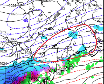
One aspect I'm seeing in the warmer boundary layered runs .. .heh, which is pretty much all of them at this point - or seems destined that way - is that a bit of a 'COL' has opened up all over New England. The polar high that was so ideally draped west-east through Ontario, and wedging down... really is not 'quite' doing so the same as it appeared to be handled... before this shit the ice/cold rain bed. I was in doubts of a warm BL intrusion .. but upon seeing that 'COL' ( area inside the red ovoid annotation abv - ) I am less head-scratching, and more completely absolved of it. Seriously, if the models are going to 'hold back' the cold sourcing within a mere 36 f'um hours of the onset as a convenience to La Nina ... tough luck. Lol..seriously though that has a bit of a blind-sided short term correction attack on clad intents and purposes about it. Yeah, I guess you can look at the 500 mb "maybe" have inferred that "inverse cold blocking" could happen by the mid level jet... but, we've seen that fire hose over the top in the past, and still ...arctic synoptic air rounds the Maine bend and tucks its way down - maybe an interesting now cast op. But, that lobe of deep cold and the attending surface high up there is really being held way back at this point. I think there will be ageo flow - has to be.. Even the most NW postions take the low SE of Worcester ...so there has to be drain in the interior...question is, is there enough cold in the COL area to keep things freezing... I think that's the supplying air mass to this things BL circus act for SNE and probably S NH /SE VT...
-
It's compounding a little, too - it's both that ... and, the positioning of the surface high pressure is bumped back W a bit.
-
I can think of 50 storms that were/are ... - although, yeah yeah they didn't happen to fall on this fateful day. I think that "yore" is really more of a highlight as to the cultural/adaptive relevancy of era for "big" events. It's why I kinda sorta wonder how bad it really was for the Colonials when/ if one could ever imagine transporting our modern tech and standards for recovery ... back in time? Like, 'magine if General Custard had a couple of Gatling Guns pointed up those hills ? 1940 wasn't exactly burlap clothed clothing, .. or wading through it to take a shit at 2:13 am in a "blizzard" ... out of a drafty log cabin hosting earwigs and silverfish ... no. But, that era did not benefit from posi-traction slip differential SUV's that could rover Mars ... either. Nor were households impervious to the elements with central masturbatory heating ... while refrigerators were full of 7 layer dips waiting for the convenience of the microwaves for dipping during any in the constelation of overly stimulating Internet and television distractions that give us the illusion of dystopia - Like, 'magine taking anyone from today back to a 6-10" snow storm of 1740 ... sans these conveniences ? Oh my god!!! 8-15 inches was traffic arresting for days .. shit, that much doesn't even stop me from ordering a pizza now -
-
General theme among guidance is clearly an active week to 10 days ( perhaps a bit longer ..) of Pacific jet. Appears slated to relay a steady diet of Sat-sonde'ed/assimilation-modified impulses in a low curvature- high amplitude, very dynamic flow. The next in line offers up another shot at impacting the region preferably Friday.. but, part of the 'dynamic' flow means changeability - which should be held in vigil ...probably until Tuesday ( There is also another time frame of interest out there around 23-25th. These Pacific disturbances are arriving around a periodicity that spatially supports that time span as the next ...and so seeing events modeled ..etc.etc ) Keeping on point, the recent discrete handling of Friday's event have trended east slightly - for cold profile enthusiasts... you like that The event its self in these recent GFS/GGEM solution ( for example...) appears to be more WAA /..isentropic lift in structure. The flow at 500 mb begins to really accelerate from the TV to New England regions .. igniting an overrunning "quasi" SWFE response. However, this cinema appears actually displaced E from the actual trough working E on its heels. The GGEM at this D4.5 -- 5.5 lead tries to keep this all snow N of the Pike... as the trajectory of the WAA appears to tip E and slows the elevated warm boundary from intruding N of that region - it's an interesting snow-lovers salvation solution, and rather than salivating over it... lol, obviously that is negotiable noise at this lead. The GGEM hints at the lagged trough as halfheartedly materializing an inverted trough structure the pressure pattern ... with ongoing or regenerated light snow.. It's an interesting look - even if conjured in the imagination of the day-dreamer model. Spent way too much time just now on this particular guidance The GFS has ... point to point, trended the entire structure E now three cycles worth - that I am aware - I didn't count/check back further. One aspect that is important for SWFE mechanics ...and overall for snow/ cold profile enthusiast, is that the lead surface ridging over Ontario in both the GGEM and GFS ...is belated(ing) in these recent trends .. built back more W into a potent CAD supportive look. If/when the trajectory aloft of the incurring WAA slopes less ( more ENE as oppose to normal to the iso-heights )...that overall implicates a colder solution by a goodly assumed amount over yesterday's ideas. This 12z's run still ultimately transitions... but I'm more interested in the trend for now, because that situation at the end of the week has a lot of smaller scaled/ higher impact sensitivity to it.. .and that high retarded a little more - say - on the next cycle, and that event gets interesting for more snow/ice than it already depicts. .. The 00z Euro was also a smidge E-S with the entire lower trop. pressure pattern and the accoutrements of various concerns. It really has a 18 hour mix storm for every N of about mid CT-NW RI ... Again, trend .. also, interesting is that despite the lag trough, it still has a better commitment to Miller B utilizing the wind mechanics in that acceleration field - apparently. I think we are inside of D5 for the formulation of this thing. This model run right now...I wonder if it commits more there... or what's going on. But the Euro is really only another cycle or two for ratcheting this thing into its wheelhouse -
-
Yeah.. so anywho - I'm with Will ...who has spent the morning in futile attempt to encourage people's perspectives on the low levels in this... There is no way the cross-guidance, unanimously supported construct of having a high pressure entry into this whole systemic ordeal ..situated as it is ( across Ontario and already anchored/CADed ...) into the region, is going to yield to WAA. That is physically impossible to mix out without the p-wave off a comet impact - It is ice to S of HFD to almost PVD... or at most, shaving temps off even higher resolution guidance - which probably connotes the former in this situation. The only way that is not the case.... the models have to be wrong about the high, and antecedent cold - both.
-
wondered ...heh. Yeah that one appears to be a redux really... I mean it won't be exactly the same - they never are. But fast flow, anomalous warm transpire above a colder lower troposphere - more so than "normal" WAA event structure... - appears likely. The Euro hinted at shifting the whole bag E ... that's probably the best way to get the cold solutions, because it's becoming more evidence that the mid troposphere over America is trying to warm up .. It should be noted that the AO is rising about as fast as it physically can on this planet - it's like "synergy" ?? It's not air apparently driving these looks, but that former factor and these looks appear almost related -
-
What - this begins tomorrow night down here... I mean in general - the whole scope ..which includes time, and geography. The gestation of the event is late Monday to early Wednesday from the TV to exiting Maine. I don't think there's likely to be more than "tick" variances... Now, ticks can certainly bite - haha - ..if they add up and folks aren't paying attention. But the scaffolding of the synopsis is pretty clad at this point. This is a weird, anomalously warm intrusion at 775 mb ... perhaps supplied by a suppressed La Nina field that in a metaphoric sence is 'hissing' ... through a leak/opportunity to bulge a weird thickness burst up and off the EC ... with a ton of cold air draped S-SE Canada. It really is like a battle ground between La Nina and AO
-
I mean this has been said by Chris, and myself ..and others, but we really wouldn't observe that much accretion as those number attempt to pop eyes and gaslight people's e-tropic high ... lol. Seriously though... at 70 to 80% max accretion efficiency on non radial objects, ranging to perhaps 45% on aspects like tree limbs and wires and such... that prooobably just knicks warning ice in the interior. It is also - I think ... - on the higher end of QPF layouts I have seen ..so I wonder if that's an over- wet run. But that ~ 1.25" axis of QPF that's more or less 'twixt the Pike and rt 2, if assuming ideal icing, ...may get .4 to .5" radial accretion on those types of exposures... Probably ends with that shards of broken glass look over side streets ...while sag timber cracks sound off around wooded neighborhoods ...For some unlucky few, even audible inside in their darkened, steadily cooling home, rendered dead silent homes - like everyone wants to be in (wtf ) jesus... Otherwise, pretty aesthetic glow. But if it stops there..this should not be huge. I'd be more worried about the backside ... The models seem to offer a pulse of CAA with some rather tightly space isobars... Don't want wind of any kind with ice loading. Having said all that... I'm surprised this whole event is unfolding this way frankly. it is unusual to have this degree ( no pun intended...) of sloped sounding .. The surface looks like the antecedence to a Miller B bomb.. 500 mb is bulging thicknesses up the EC and astride ocean, and it's 564 almost to LI ? That's a La Nina 700 mb thing there... I almost think this system's unusual structure is really a battle ground system that's removed all other noise and is exposing a tug-o-war between a strong -AO, vs La Nina ( HC?) stuff.
-
It's not "over" either... Look, both sides of the question seem to knee jerk to extremes every ensemble cycle ... It may take a couple of week .. maybe even three - The question's really related to how spring will begin to arrive, subsequent early speculation about what form it takes - then, deeper into March. At which point.. it should be f'n over. I think there's been some local-decadal scaled conditioning to 'expect' winter to protract into the spring, but March is fickle.. and 1/3 of them have been above normal with embedded obscene heat since 2000 anyway. It just that over the last 5 years, that has been rarefied. It's really more like a signal that gets us a better chance for one of those 1/3 warm years ... in March Fairly? - it probably shouldn't have really be brought up in this thread - you can thank yours truly ... Pretty sure I posted about this last week when the GEFs handling of the AO clearly and concertedly, every member included, tightly aligned along a +5 SD recovery ... It's just that the ballast of that recovery starts ..now ( really ..) through March 1. We don't really do threads that are seasonal-based. If anything, last night's CPC as anyone can go see ...is even more recovered - with unusual concerted agreement. That looks like a warm spring hemisphere in that particular teleconnector out there into the first week of March. It's funny ... while that is happening the operational GFS looks like it cannot actually be a part of its own ensemble system - like it stands apart as an distinctly different physically scaffold'ed model design! It could not be more diametrically opposed. If it were more in disagreement out there toward week two, it would be modeling on a different planet altogether. I don't think the recent trend and current "panache" of its board of ensemble members like the direction of the chair in this case.. and proooobably are gunning for the latter's retirement for being too old and out-moded, and not seeing the direction of the company. ...Ha, I like that metaphor. It's like "Meet Joe Black," only the Reeper in this case is the combination the La Nina and the HC expansion working together, under and the inevitable return of the sun. So with every member having recovered all the way to +1 or 1.5 SD, and the PNA slipping negative... and the NAO neutral positive ... There is no combination of those larger mass field indicators that really suggests anything resembling the GFS hyperbole winter signal will take place... It attempts a monster -EPO, cold dump... setting up Canada to justify what it does every year at this time... pump out model runs that end summer until next Thanks Giving! But I'm being hypobolic The GFS does this every year around this time ... It's native physics some how, some way ...negates seasonal change. I think it is just uniquely qualified not to detect spring because the model also rages in a N/stream hard-on, most of the time anyway. It runs some -6 to -10 dm colder heights N of the ambient polar jet compared to all over guidance, at all times, beginning beyond D4 .. 5, and growing more discernible the deeper on in range. Since this modulation appears to maybe need a threshold out there...week two, its likely to see it last ..and then argue when it starts to see, too. There could be a storm with blue bomb/snow potential Feb 23-25th. The GGEM/Euro/ GFS ...and every GEF members carries a trough through eastern N/A during that time, and there is still substantive cold N of the 40 within grabbing distance ...
-
This just feels like a NAM too far northwest scenario to me and as it comes back Southeast in future guidance it may shave a little of the QPF off a typical buyers beware corrections for that model for things that are relaying inside of 60 hours. i’m also a little bit surprised honestly that the 500 mill bar looks a little stronger after keeping with the seasonal tempo going weaker ... this is the first one I recall that’s going the other way getting closer - interesting
-
Yes! I posted about that earlier today that it’s usually not much higher than 80% even in best case scenario do micro physical phenomenon ...kinetic energy upon impact and splashing you just can’t freeze at all then if the temperature is getting up closer to freezing you’re definitely not gonna be able to do it as quickly and then I’ll take even more away. I think in 2008 Worcester County had an average 3 to 3 1/2 inches of rain and what did they get out of that accr 1.3 1.6?
-
Almost like the system is trying to rush the backing off of the arctic isolation slated to begin in earnest over the next two weeks
-
I think it’s too far northwest too done that all year long it’s been doing it for 25 years
-
What’s strange about that… I’ve lived in this part of the country for 35 years and I dont recall that kind of confidence interval for ice in Northern New Jersey and Fitchburg mass at the same time that is a strange scenario
-
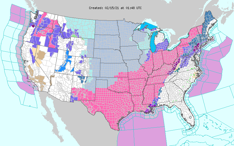
on a separate note... i don't think I've ever seen that much of Texas under a Warn headline - wow
-
Done when? what time do you think folks are extrapolating for - ... tonight? Tomorrow? ... Mid March in global f'ing warming with a La Nina spring climo - yeah... winters over
-
NAM NW bias beyond 60 hours
-
prolly not gonna verify as is ... obviously, but the D10 Euro's looking rather spring -like already. I still suspect this is a different spring complexion comparing recent years -.. I figure it for a move over in March... thinking the 2nd week ? But it makes sense to see early extended ranges start nudging the suggestion along like this - ...if we were waiting until March 3 to get a solution on D10 that looks like that 850 mb thermal layout...I'd be pushing things out to the end of the month. But this gives it time to fail ... come again...fail...then start to stick - Also, the AO still recovers to neutral or modestly positive SD out there beyond the 20th... and with the PNA trying to collapse ... I don't know where sustaining winter into March can really come from with this hemisphere of La Nina + HC being free to expand heights over the Americas ..They want that, then dipping the PNA may synergistically realize a bigger proportional response to the base-line statistical suggestion - That means weakly -PNA = higher heights thaan one might think. This isn't a March thread though... I still suspect February is good for at least 10 days and negotiable for another week after that ...
