Typhoon Tip
-
Posts
44,568 -
Joined
-
Last visited
Content Type
Profiles
Blogs
Forums
American Weather
Media Demo
Store
Gallery
Everything posted by Typhoon Tip
-
Y'allz ability to disconnect from rationalism and apparent understanding, and still allow a single guidance depiction evoke "dashing" of anything ... is really rather remarkable - lol...
-
Not sure what NAM biases are for this sort of synoptic evolution. In past diatribes ...I have futilely attempted to encourage folks simmer down, and to consume 72 hour NAM with an extra dose of incredulity, when it comes to fuzzy deep navy blue or even magenta snow-QPF off its west Atlantic/ .. near EC cyclogenesis and track guidance. It just did it on this list gig frankly - ... post after post after posts strung together explaining how 'it could actually score a coup this time.' Lol .. No but this is not a west Atlantic cyclo - babble low. Nor is it a relay through the outer short range/ .. mid range temporal seam. Last night I was intrigued - a little ..I say that in the relative sense - by this critter because it is riding along what I see as a rather enhanced baroclinic region associated with the mean polar boundary. Right now ( and modeled throughout the week ...) the vagaries of the winds et al have managed to draped some rather breath-taking cold, astride the Canadian side of the U.S. border... As these 'little critters' zip along ...they subsequently probe plumes of that air mass down; these then mix into and homogenize the air mass quite cold within the mean E. low level wind trading around the underside of the attending polar highs up there ( synoptically suggested in this abv annotation... ) As these ripplet jet maxes that seem innocuous ( and really are in lesser circumstances ) ... zip along, they have enough momentum discontinuity to trigger some restoring inflow lift. But, because it is flowing into a rather upright ( tendency..) of the elevated frontal slope (think of it like a cold wall as opposed gentler slope), that will maximize psuedo adiabatic instability popsicle headache. Particularly in the 850 to 700 mb sigma depth. It'll come down to where the SGZ heights situated in the passage ...but ( 1994 ) and other historical examples show that almost non-discerned jet accelerations along these sort of thermally compressed frontal interfaces like you see above - which sets up for tomorrow and also persists through next weekend if you believe the general handling... - have a way of delivering goodies. It all means these little guys may over-produce. Over-produce doesn't me 38.7" of snow... it means, there's a like ...I dunno, say 30% top side that's negotiable and probably not really able to be forecast - almost synergistic, via maximizing one or two kinematic process among of a stew of minor events that by weight ... sort of hide them. ( This whole song and dance may play out again later Thursday ... then again later Saturday - this sort of nickel repetition has been pretty persistently in the models, too. ) In summary: this doesn't say where this "maximizes" .. . it just elucidates the enhanced potential/ .. native instabilities that are in place and fertility for event success. I wasn't surprised when I saw some of the overnights start double .2" liq equiv to .4 or even .5" ... Whether this comes N or S along that axis - I yeah good luck... Probably the IBM cluster LOL
-
Well heh ... “gang busters “ shouldn’t really be part of anyone’s expectation. I think those NAM 2” aren’t set in stone with those Synoptics
-
Yeah NAM solution would offer a couple inches at best ... it seems paltry lower side of guidance. Not sure it has to be correct in this baroclinic rich environment with mi level jetlets riding by
-
3.75" in Ayer... 26 F S-
-
Nah...you're fine Nothing worse for readers like a fool with a red pen - lol I tend to flood rhetoric into the turn of phrases - it probably obfuscates ( unnecessarily confuses ..) the flow and impedes actual communicating. But I like to write ... it's a thing for me. If I kept it strictly clinical and redressed some of the terminology ( scientific ) around explanation instead of making word-bomb statements bigger than storm being described, ... like equivalent potential v-displacement, that really doesn't mean anything to 90% of the readers in here - it's not a knock. It's just an educational/exposure thing... Smart people with good souls my lovely dinner guests, only. Truth is, you don't need to know those words ..or the complex field of math and physics that is used along with, to understand charts and/or eventually get an impression of what they may mean for weather. I can vary the style, .. and it'll be completely different. You know, - like when I'm humiliated Kevin for example... just kidding K
-
Oh ...that's right dude - shit.. ahahaha ... Welp, look on the bright side - you just earned yourself a name in the museum of greats if it goes ahead and sort butts ... 'The Raymond Superbomb' Well...if it's any consolation there may not be a 'big fish' - this is just early speculative assessment based upon likeable hemispheric signals and an eerily vulnerable baroclinic powderkeg ... ( haha ) ... yeah, I guess I'll go ahead and admit, it's not the best pretenses to wanna leave this region if one is any kind of a warm-blooded storm utopic seeking enthusiast Tell you what though ... it may go down as the biggest waste of potential energy ever failed - it's just not a metric anyone bothers to keep track of.. But I tell you what, if you're sitting at a blackjack table up 3 large off a 3 Benjamin buy-in you'll know what our visibility is back east at that moment
-
And ...having seen now the D8 ... with that hyper bomb in the lower Maritime region being the result ( eventually...) imm downstream of that phasing .. it really wouldn't take much of a western ridge earlier steepening expression to get that closer to the EC... Again, needs work - and I wouldn't bother mentioning it if there wasn't tele convergence going on -
-
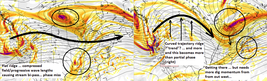
We've seen it in the various modeling and have been onto the notion of weak impulses making use of the enhanced baroclinic axis ( not gonna re-type that sermon... ).. Erstwhile offering every 2 day perturbations bursting open light or light to moderate blooms / .. attendant weak low results through mid and end week. All the while - not to re-iterate so soon .. there is an EPS and GEFs/ .. general hemispheric signal for much more. We had just not yet seen the operational runs bite down and really hone anything in that 11th - 15th ... 17th time span. This run of the Euro is the first to take what I would consider to be a first step in adjusting larger synoptic features. 00z vs 12z ... ( and I only bother to annotate this tedium because like I said, it seems to be the best 'first movement' ) Left is 168 hour ( 00z); right is 156 hour ( 12z ): This run seems to hint pretty strongly at availing of the hemispheric signal for phasing - taking the fist step in modulating toward ... It's got some work to do. In order for this to be more successful ( less negative interference ..), we would like the flow to slow down - I think that can be handled in subtle dose of increasing western ridge ( trade off...) "if" or when any would-be emerging western ridge amplitude emerges further - ... which concomitantly, we need that to happen either way. As is, this run does vigorously engineer a cyclone that is vast more deep and representative of the general potential...It really only scratches the ginormity of the potential that will be inherent to the time span in question .. Yet still manages a 970 mb low escaping the EC... close!
-
..... me? out of words?
-
Just noting also ... fwiw - the Euro/GGEM/GFS/NAVGEM/ICON/KOREAN/NAM/JMA/EPS/GEFS rule appears in effect - they all have a weakly closed isobaric bulge with qpf lobe over top
-
For now ..yup
-
Well that's the thing .. it's minimal forcing ( yes ) like you say, but the growth would be decent with UVM feeding the SGZ ... that's sort of how we get to over-produced results. Maximizing one or two kinematic processes among a stew of modest aspects and suddenly we got 5" of solid advisory - But agreed with steady light to moderate, ... perhaps stacking by virtue of the over-arching pattern being the primary cause, it allows it to carry on for 12 hours that way ...So we may end up some interesting amounts for being only a vague cyclone mechanics. Yup -
-
Ceiling .. perhaps. I'm thinking it's 4 ...maybe 5" over achiever frankly... I think there's a cap on the cyclogenesis proficiency - it doesn't have a lot of jet mechanics for inducing the cyclonic scaffolding of jet structures... but, it has intense baroclinic/thickness packing ...so, any UVM is maximizing due to a steep elevate frontal escape ...and with a cold atmosphere in place, an IB/ SGZ efficiency look to it - ...have to roll up sleeves and look at discrete model products and other machine assists to prove it, but just based upon my experience/ synoptic overview combined - sure other Mets have hot takes too lol
-
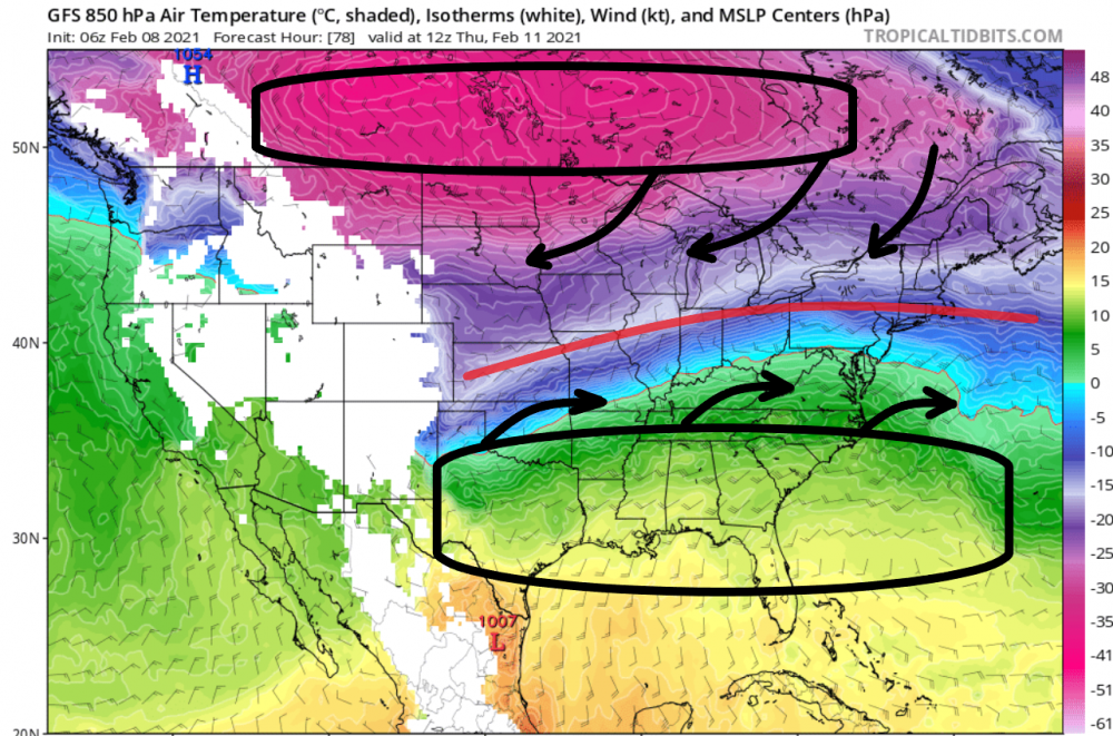
This pattern contributing to Tuesday ... situates throughout the rest of the week, too. The "low" on Tuesday escapes seaward, and there's really only negligible suppression south of the apparent baroclinic axis .. such that it persists roughly along the 39th parallel through the end of the weak - contributing to Steve's thread impetus... but that part of this blurred by fast flow uncertainties... I mentioned this in the other thread ( month ); this is a powderkeg week ... probably through the 15th .. 17th for that matter. We are getting a semi- permanent + PP draped out from the NP/S Manitoba to Ontario .. under which around that 39 there is a long easterly flow collocated with ton of thickness packing. It's spring already along the Gulf of Mexico interface region - meanwhile, sub -20C plumes of air are amassed under said surface ridging over S/SE Canada. That's gas, plus air ... well mixed to the proper detonation ratio - where's the match? What makes this particularly interesting for me is that while all the above is setting up and synoptically evolving in ALL guidance through the mid/ latter week ( possibly beyond ..), the GEFs and EPS indicate a -1 to +1 SD correction in the PNA mode ... It's like a crime to transmit that much PNA mode change in the stormy direction, whilst that powderkeg exists ...and dare NOT storm.. Wow. Yet, all we get is/are these piddling WAA bursters and shrapnel faux cyclogenesis smears like Tuesday - That said, and to point ( sorry - just wanted to cover a bit about the over-arcing theme of the week/ .. next weekend ) Tuesday I think has a shot at over-producing. Mind you .. that doesn't mean calling the Nat Guard and putting them on stand-by or anything .. But, that intense baroclinic gradient is so rich that anything that breaks out gets a kind of 'synergistic' feed-back/constructive interference and even weakly close attending cyclones may end up with a couple of sneaky parallel bands on the flop side of the polar boundary bulge.. You can kind of see that in the QPF management in these runs. I love nickle and dime patterns - ... It's almost like Tuesday, Steve's notice for late Thursday ...and that unfocused aspect later in the weekend, is all one event - just different chapters in a novella. And, while this is all happening, there's a back ground potential to see something more important emerge given to tandem -AO nadir ( timed for 7 days from now), together with the -1 to +1 SD PNA..
-
Yeah ...I was just being snarky about the phenomenon - sometimes in the past ...I've crashed at night with this comet impact baroclinic leaf explosion on satellite clear to Buffalo, with rad filling in over PA ... wake up to partly sunny .. whaaa But the weather -tap radars are a bit less ominous. I've noticed that in the past when utilizing Intellicast's radar as a cheap bastard ( lol ) that it seems to smooth shredding and make things look more congealed than they are in reality .. The stuff that matters is probably restricted to SE PA- SE NY
-
That's exactly what occurred to me this morning, that repetition of light/mod events ..each smearing in the fast shear but maintaining enough identity to trigger potentials. The thing is .. that baroclinic axis ..roughly along 39 N from Denver to NJ ... is excessively rich across the bevy of guidance, ens...means etc.. You know this, but any time there is a wall of thickness packing, with easterly low level balanced wind... it's a baroclinic time-bomb. Even these very subtle difficult to find perturbations in the flow trigger these Tuesday type "critters" and that's really what 1994 post NY that winter was - just spraying critters up along a thickness packed powder-keg. All the while .. there have been/ are interesting EPS and GEF teleconnector suggestions for something bigger from the 11th through the 15th. The operational runs - frankly - are frustrating as of late because they just refuse to take the bate. I'm not sure why ...even the operational Euro is failing to do so - that model? Beyond D6? Given least excuse imagined to curve the flow ...it will do so! Having a -1 to +1 SD PNA mode change that begins later this week and wends its way to that the positive state ( EPS and GEFs), whilst the AO actually goes even lower ( -5/-6!!) .. should have been a memo for that model to go crazy - but it's like almost no reflection of a +PNA --> +PNAP response beyond the base line climate structure ... It's frustrating - Maybe the operational models will win ... I'm not seeing the GFS as taking advantage either ( nor the GGEM..) - this is all an ensemble mean(s) derivative - uuuusually when this sort of contention takes place, one or the other wins - either the weight of the ensemble begins to convince the operational to come out and play ( lol ), or ...the higher resolution/more dependable pedigree blend does and we see the lesser resolve ensemble members start to fall in line the other way. Tough call which way it'll break - good luck. But, seeing as the erstwhile -AO is established empirically, and the SSW stuff appears to be hitting the annular mode pretty hard over the next 10 days, that seems it should be a momentum red flag or nod at least as being big influencing force. And at some point.. that raw power of that kind of extremeness should cause the mid latitudes to curve around it - I think that sort of hints which direction this should break. It's a fun time, because whether something more cohesive and coherent begins to materialize out of the 11th - 15th ( maybe 17th ... ) ether, it seems either way we are saddling the conus with that rich explosive baroclinic instability and tweener features to keep the entertainment going.
-
Radar presently casting a classic head -scratcher looping. The cinema of it looks like it can't miss .. snowing moderately clear to Albany .. Yet guidance clear consensus doesn't - The IR look ( satellite ..) also shows that altho shredded, there's a tendency to expand and congeal over NE PA and SE NY ... too - it's the ole, 'okay how's this going to do it ' game
-
I’m wondering if we may be getting an oh so subtle kick back from convection process
-
This is probably the run where the NAM initiates enough convection / ..exhaust into the down stream that very minute .. almost non-discerned height resistance brings the 1.2" liq equiv almost to FIT mass... everyone's like whaaa
-
I realize all point an clicks are partly sunny for next Saturday, the 13th, but ...this could break dramatically in a direction were 'sunny' anything is a demonstratively inappropriate adjective for that day... In fact, beginning Thursday and may be not ending until Sunday. This is a scenario where there is a medium registry for hemispheric signal in that 11th through 15th time frame - I mentioned this a few days ago, but this thing tomorrow is/was distraction. This signal is still there - granted a little more prevalent in the GEFs ... but ( thank you Steve ) the EPS shows a -1 to + 1 SD modal change heading toward the ides of the month, and so the blend between them is sufficient to at least be aware ... a better performed/emergent +PNAP circulation type, could materialize over the western U.S. at any point in the model cycles leading and entering that time range. It's dangerous, because there is a decay -NAO ( westerly limbed) that is probably going to be exerting a southward push ...and should that PNAP shake hemispheric hands, that lengthy snow/mix/zr/cold rain already noted, may morph more organized than a mere overrunning aspect. That's a durational ordeal ...mainly by virtue of the fact that is' basically everywhere E of 110 W across the mid latitudes are being torque around a modest cyclonic rotation with respect to the SPV(s) pearled out/or centered over S Canada... That's the piece we gotta watch - just waiting for the western ridge to pop ( and the snow storm last week did that inside of 6 days ... upping the confidence considerably ..) - hint I almost expect it does... That SPV may start carving S-E ... Dont' want it to en mass however, because it'd be too much and to compressing on the field ... Lots of complexity to it but I doubt the Thu/Fri + monitoring is so quiescent -
-
Yeah ...I don't know- do y'all have protocols for this sort of lateral banded routine ? I give them a pass on this because the ability to see exactly where the axis aligns is outside of the purview of the technology. It seems to me the band, albeit more likely southern CT to SE zones down here cannot be ruled out as ending up NW by 30 clicks then suddenly ORH-BED is unprepared - I think this is just one of those unsavory situations where hands are cuffed to responsibility, to keep the public aware, while not having the best of confidence in the what/why, discretely. Not that anyone asked but this looks like a moderate impactor ceiling to me, primary SE but I wouldn't bet the farm either. The NAM comes back at 00z with .8" at logan, suddenly ORH-BED are getting 6" in 3 hrs
-
It does sort of give the allusion to this being a two shot redux deal, doesn't it ? nickle and dime 'em
-
It's negatively in interference wrt the ( La Nina + HC expansion)/2 footprint of the planetary state.. It doesn't mean it won't ultimately .. but the wave power has to become massive in order to supplant the former two ...which in tandem is actually a constructive interference ..probably creating some difficult to demonstrate empirical "synergistic" effects that really makes it hard ... It's probably back piling for another week and then it'll just decay having failed to get into that side of the RMM - ..or if it does...it's decaying ... Not likely to ever come around, nor be much of an influence on the genera circulation of the hemisphere. It's not a late 7 - 8 - 1 - 2 favoring hemisphere this season. It's interesting too ... because the AO and MJO have a negative correlation on the left side of the RMM diagram/wave spacing. Which means .. when it is negative, the MJO wave strength tends to be strong, and in those phases listed above. Something else lurks and is compensation, interfering with that previous century- mode. The MJO is a pattern enhancer - not a pattern forcer. I have noted ( personally ..) since the 1990s, it seems lesser involving frankly. When the hemisphere is in constructive interference, the wave propagates robustly ... and then there is indeed the appearance of synergistic feedback that makes it "look like" the MJO is the primary cause... But when in negative interference, the hemisphere carries about in pattern morphologies that step on the MJO index - almost like ignore it.. heh - either absorbing it's mechanics and/or not allowing it to propagate at all; the forcing in the general circulation may appear nonexistent - I also believe that as this HC expansion stuff continues to become more prevalent, any of these tropical source-origin indexes become gradually less successfully correlating over time. That includes the Pacifc ENSO package - .. but that's all hotly debated and in science ... It's been a weird hemisphere ... really dating back to 2000 if we wanna really dig.. but, particularly the last 5 years with the incredible velocities and gradient saturated looks. It has not mattered really whether warm or cool or neutral ENSO's were afoot - owing most likely to the 6 dm z-coordinate growth of the HC since 1970 ( as is documented and formally published ) and that increases the ambient gradient overall ...particularly during Boreal winter ( probably in the S- hemisphere winters as well...) But these velocities ? They tend to muck with correlations/teleconnector signals, because fast flows 'stretch' wave lengths ...and that means that R-wave fixtures tend to 'cog' to the next gear - so to speak.. Such that what one thinks of a +PNA in 1980 may not really set up the same way now... ( so to speak...). But I'm babbling off the MJO discussion point .. .ha
-
uH - my bad .. .that that was EPO ... EPO ... EPS ... let's call the whole thing off!