

Typhoon Tip
-
Posts
44,568 -
Joined
-
Last visited
Content Type
Profiles
Blogs
Forums
American Weather
Media Demo
Store
Gallery
Everything posted by Typhoon Tip
-
Boy ... I betcha he feels 'inadequate' standing next to that -
-
For some narrow band this could be one of those events where neither icing nor snow makes the Warning cut ...but the impact proves those distinctions irrelevant -
-
Can someone get on the horn with nws and let 'em know their websites hosed for afd's ? ah, they were probably updating -
-
That doesn't seem right - I mean, that nearly matches this thing's fast movement and oh is that's cumulative for 85 hours then? I'm asking because that requires a lot - duh... But we don't really get proficiency in accretion that utilizes all the QPF. I think it's like 80% ... I almost think of it like that weird riddle-question about should you run through the rain, or walk, because if you walk, you spend more time in the rain, but if you run, ...you collect the rain drops you would have missed if you were not there, so which is better... ( you know? that riddle-question that makes you want to punch the person's face?) With icing, ... light fall rates in very cold temperatures end up light pingers...but...bump it closer to say 29.5 .. and the proficiency at accretion is very high ratio ... maybe better than 80 by some. But step up the intensity of fall rates and splashing and other micro-physical effects, like kinetic energy of impact and increasing LH of phase change.. Either way, it's not like if 1" of liq equiv falls, there's 1" liq eguiv of riming - But I guess if that 72 to 84 hours worth - Thing in, Pivotals attending QPF doesn't show it appreciably collecting prior to 06Z Tuesday across the region... so, that seems to suggest this product assuming whatever falls accretes - I wonder if this is flat rate -
-
I like how the Bend of Texas to STL is like a 16 hour drive in constant Warning ...
-
.... man ( lol ) ... it's really going to be something of a rather remarkable achievement by the atmosphere ... when/where collectively, as the offices across the continent necessarily created this dizzying array of higher impact headline tapestry ... ...we here in New England only set by and watch that same atmosphere finagle a way to f' it all up for us by the time all that bottle necks into the NE. By the way, that's interesting seeing Warnings down to the Seattle shore -
-
This is what this looked like to me yesterday as the course of more likely outcome - whether that's the course of least regretted gamble ..heh... not sure - but just apriori existentialism having lived through this climate for decades, combined with actual theoretical Meteorology ... not surprising this run re-emerged after the 00z may or may not have attempted futilely to refute the former two supplying "objective wisdom" ... It could still bust more IP and knock that back... We've seen 2,000 meter tall sleet columns before ..albeit rare. But cold temperatures win in the low levels...I'm personally > 75% confident of that given everything, regardless. Oh, but, relative to what really falls, I'd maybe take 2-3" off the top of that along the southern half of the snow, and maybe actually add 2" in the N half. The southern aspect will be 11:1 snow with IP hammers ... and that'll keep it in the 6" .. 7.5" range ( I think..) while this cold, likely being under sold ... will beef up ratios closer to 15:1 so those 10:1 numbers could actually be low N of ~ Pike. Something like that with IP/ZR in CT/RI seems to fit climo too for this sort of smearing event/isentropic ... but the ice shouldn't be undersold where it occurs, either; that looks like a narrow axis of efficient accretion with this beautiful supply of undercutting tuck winds/ageo drain set up.
-
Yeah... I mean... this is kind of a mesmerizing 500 mb look, run-to-run, and distracting. Hasn't even gotten into those age-old, tried-and-true local studies crap with burrier/"tuck" jets this, and index-finger-rule model error for BL resistance that. Those super uber detailed popsicle head ache aspects that always win ( btw ..) that simply will bust ZR lines farther S... Whether that means more IP depends more on mid level stuff. This has a protracted front side grits, freezing dz, flurries and light snow... from there, one of two options in my mind: it's either going back more snow in guidance, or a mostly ice verifies. This is not raining... that's total bullshit bad modeling - straw man..just sayn'
-
The Euro might be giving a faux impression of amplitude on the 00z run .. if one is using the thermal fields, ptype as impression guide. The 500 mb was in fact slightly weaker in the vorticity layout by the time 84 hour is then relayed onward as whatever that 'smearing' that's left is, that is nearing 75 W, wends its way along a slightly flatter trajectory. Seemingly trivial that does connote slightly weaker deep layer mechanics - but that weak mechanics alters the trajectory of the stream lines exposing where advects that gunk through New England by 90 hours... more ENE as opposed to NE in the previous cycle. That, believe it or not, has a counter-intuitive way of being a warm solution. By virtue that trajectory being a little bit closer to the actual lower b-c axis, - that still more proficiently materialize the 850 to 700 mb restoring jets blowing up the polar side of the elevated frontal slope.. causing a net warming in that layer. I've seen guidance et al do this in the past.. Until the 500 mb comes sufficiently E to really ( finally ) commit to coastal ..effectively cutting off those elevate warm intrusion layers... and then the scenario at hand flips into a cyclone model proper..blah blah. This ain't there yet ... but.. If this comes a little bit more SE at 500 mb on the next cycle, this may flash back to a snowier solution NW zones ... and we'll see where it goes by late tomorrow's runs. I'm not sold on IP/ZR to RUT VT in this ... I've been seeing tendencies in the models, ..across all of them, to tone down amplitude relaying from outer Mid range to inner time frames...and given the SPV layout up N and confluence and all that jazz.. .it seems the correction vector is not really pointed at a BTV 500 mb wind max transit... Maybe? sure - but the air moves like water and tends to find the pathways of lesser resistance. The other aspect that stood out to me in the overnight runs is that the EPS signal Scott pointed out a couple of days ago has been occurring in increasing frequency across the bevy over various guidance, which is to close the gap between the "new" Monday isentropic initiation and wave. We probably could end up with 2-4" of snow NW ranging to substantive pirouetting SUV glare icer SE and probably we've been ignoring. The result in the GFS is almost no lull now at all... This could be a 30 our ..36 hour ordeal by virtue of the fact that the axis of overrunning and subsequent book-end "main wave" are running up parallel and is thus is a long corridor between 12z Monday entrance ( SW- --> NE) and exit some time on Wed... OT: The late weekend system may not go west... I like the Euro's depiction because in the models that are trying to take the surface "quasi" primary into eastern OH and vestigially into western NY, whilst only vague commitment to secondary ... all that? They are doing it while the 500 mb is dramatically in a decay sequencing of it's mechanics and the entire trough axis is zipping shut into a shear axis by the time it actually all collocates with the Eastern Seaboard early Saturday ...that means the support is attenuating rather discerned and it seems these guidance may correct toward flatter solutions as that time nears and cleaner deep layer integration emerges in future cycles... that's my early assessment on that end of the week ... There may yet be another event around the 23rd. I mentioned a week ago I thought February is a cold wash ...still believe that... I do suspect however we may ( more at seasonally ...) break harder than recent year's March's toward a spring ...given to festering La Nina + HC planetary footprint lying in wait... albeit merely presently suppressed by a dominating polar signal ... Once that appears to neutralize ... leaves mid latitudes nakedly vulnerable to the former - ... supposition for now. But fairly certain GFS won't be the guidance species that is very well adaptive to the vision given that it thinks there is only once jet gradient between here and Alpha Centaur and that's the N stream ...even in July ..
-
The 18z GFS doing everything it can to meld a Monday overrunning start up/lead wave in with this to make it a day and a halfer
-
18z ICON hints at a cyclone split like back in Dec. ... steins CT out of half of it heh
-
LOL... the secret to a good troll post: it has to not already have been covered -
-
Oh ...I think you're meaning Tuesday and Friday combined - Kev? as in, Tues = .5" Frid = .5" Together = 1.0" ... Still doubteful for me. .5" pushes the tin in this case because to get .5" it'll have to come on in heavier dose due to limited time of each event - they are movin' and truckin' man. And, a goodly percentage of that ( save for some really isolated pocket perhaps ... not enough to substantiate a headline) is likely bouncing or snow. ... I think a median glaze amount is ... .25 to .33" somewhere's in there... But, this is all us wasting time in minutia over a situation that could easily tick more snow... I really don't think this can come NW of where it is now frankly - no way. Because although the SPV frag is trying to phase more in some guidance, it is also moving too much in the x- ( E ) direction on whole, so it's as much a suppressor on the track.
-
Yeah.. no one asked but I'm pretty sure that was a neggie EPO, "neg-like" PNA...and a positive NAO year... actually very much so in the latter. 1994 In fact, I recall up at the lab ( UML ) Dr Colby doing a FAST 1 demo about the vortex over E Canada ..becoming so extraordinarily large and dominating it more than less backed SW and enhanced confluence as a semi-perm feature over lower Ontario. It was in a way a pattern so f-ed up wrong, it went all the way around and ended up good - hahaha Anyway, then these flat Pac waves were seeding the wedged cold every 48 hours ... That was an awesome stretch - in my top 5 favorite 'stretches' ... That period contained the weird OES IP storm.. In Acton, we had 1/4 mi visibility ... 1/2 of which was OES snow attributed, with beautiful aggregate clusters falling whilst some other percentage of the visibility was mitigated by insane sleet. It was like 17 F too - I was a kid then ... I was pissed thinking it was personal - like... " if this sleet were only snow too..." - how you get into that head game. But looking back, never saw that before or since ...it's got its import by rareness alone. Pretty amazing to later see a warm layer at like 700 mb with the soundings slopes that vastly left that deep in the atmosphere.
-
Something like that ... sure. Plus, we have IP and snow and pixie dust and all kinds of weird shit that has to be figured out - ... big ice. ha - There should be a "big pain in the ass" type of storm characteristic established in the on-line social dystopiasphere - who's with me!
-
People post what they want ... it's fun and all... annoying for those trying for objectivity and lucidity to wade through a cackling bus-stop of poorly comported audience members... buuut, can we reign in the "big" adjective on the front of the ice ? not sure what other mets and skilled enthusiasts are seeing but this doesn't quite have that kind of look to it . I guess 'big' in that context is a bit subjective... but big has usually got a historic connotation to it and it really shouldn't in this - for now. Ice storms seem to almost need now casting more so than snow storms - there's that too. Probably owing to the fact that the models don't resolve the lowest 100 ... 200 mb of the atmosphere as well, so cold wedging can be "invisible" ... But I've seen ice storm warnings end up forgettable ...while advisory for winter weather leads end up being 1:10 years deals. These are still fast moving systems and probably the QPF is overdone as it is.. ..
-
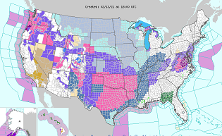
Yeah... I agree with Ray's chart but would lean any correction thoughts SE... how much how little... blah blah ... but I have a hard time believing that larger synoptic set up allows/ intrudes freezing types that far... It could- these models don't layout things that can't ultimately happen - they wouldn't be much use if they did... But, when a given model's scenario needs everywhere and everything else to be perfect to get to their solution .. you can bet, everything around it won't - in that case, cold always wins when the +PP is N.
-
Yeah.. okay - duh - this is < D5 on the Euro .. mm, time to capitulate a bit more. I don't have problems so much with the Euro less than D5 .. 96 hours and an open wave is cutting off the MA SE of Cape Code... This issue here is detailed enough to question even the Euro's handling of those vertical sounding/ .. profiles N of the low track ...so perhaps a "tick" corrections save regions that 'want' snow ( haha ).. Otherwise, that's probably a ice storm in parts of the S zones - though perhaps short of warning criteria due to half of it bouncing variety. Probably to about the Pike... then more bounce than glaze N ... then to snow Rt 2 up into central NE... something like that ... It could IP to S NH if there's one of those super elevated heat slabs like in 1994 We're probably over due ( the second more reviled statement of statistics I've ever heard! ) for an ice event for a couple reason. You usually get one per year .. however worthy of headlines or not. Thankfully not - personally, while I do admit they can be aesthetically pleasing to the eye, if/when the power goes out ...? I find them revolting to look at. F it! keep 'em. Not worth it. Anyway these fast flow patterns ...they should really be doing overrunning variety event types more so. We've probably been lucky this season to date, to have a La Nina/ HC footprint under a whopper -AO ...and not have had an ice storm yet. Come to think about ...wow, no kidding-
-
oops, wrong thread - moved...
-
you know ... from orbit - The storm enthusiasts should almost rather not wish the time away between these events - not that anyone is.. just sayn'. You went through this horribly long stretch... to the brink of sanity ... day after day after day of being stuck in a Pandemic internment camp, and having nothing to turn to - an active pattern would have been a poetically deserving recourse - but no... Folks should really appreciate the totality of this era ... which began, 2 weeks ago really and crescendos early to late next week - ... there's still some modest debate on-going about the 14th... bit more yet needed re the 16th ... All the while, that thing at the end of next week is less than 7 days away ... It really could get an early thread going for it... Perhaps as reward for your enduring perseverance ...this nickle -dime pattern- whether one of these ends up a headliner or not .. - is at scenario over the next week where no model cycle is boring. It may not offer what one wants to see necessarily ... but it will certainly keep you on your toes.
-
oh.. heh, right - like when you break it to pieces you get those tiny white balls - sumpin li' ghat
-
That product is also the whole week's cumulative - I don't have a problem with light to low end moderate events - that seems to be a correction staging point... others, like the 14th, have do-do to less even. The fact of doing so seemed to rub the wrong way, and as usually is the case... if someone brings in a lucid objective red flag to the fray, people knee jerk react to the facet ...as though it's - I dunno - some troll thing? to vanquishing everything ... but I'm not gonna get into it. I never said it wasn't coming yesterday ...
-
I think this is more what is likely to happen frankly ... although I'd be inclined to shave 2-3" off that layout This antecedent air mass appears too liberally eroded out by the Euro (00z) and this recent GGEM solution(s), given to phsyical limitations of having armed polar high N-W, while the baroclinic axis is clearly already S-E of the region.. Not sure why these runs are running up that much warm intrusion to the surface/lower sigma levels... but, even if they are right in principle with 'compacting' the front N into southern throwing distance, I suspect the ptype bands are not as liberally smeared IP that far N into the interior. Short version, there valid reasons to question the Euro( 00z) GGEM (12Z) Oh, that's the whole week's snow - okay.. I thought that was just the 16th
-
is it still in 2nd place over all - lol ... always been a mystery for me how it scrapes that performance
-
Lol - I don't know what those are called in all honestly. You know ? those tiny little 'dandruff' sized balls of white that bounce on the hood of a car. It'd need to do that for 20 days to get an inch worth, but they're real. They're about the size of a single 'grit' ... I dunno. It's like the pixie dust Will was mentioning above, only it gets balled up - balled pixie dust maybe


