Typhoon Tip
-
Posts
44,568 -
Joined
-
Last visited
Content Type
Profiles
Blogs
Forums
American Weather
Media Demo
Store
Gallery
Everything posted by Typhoon Tip
-
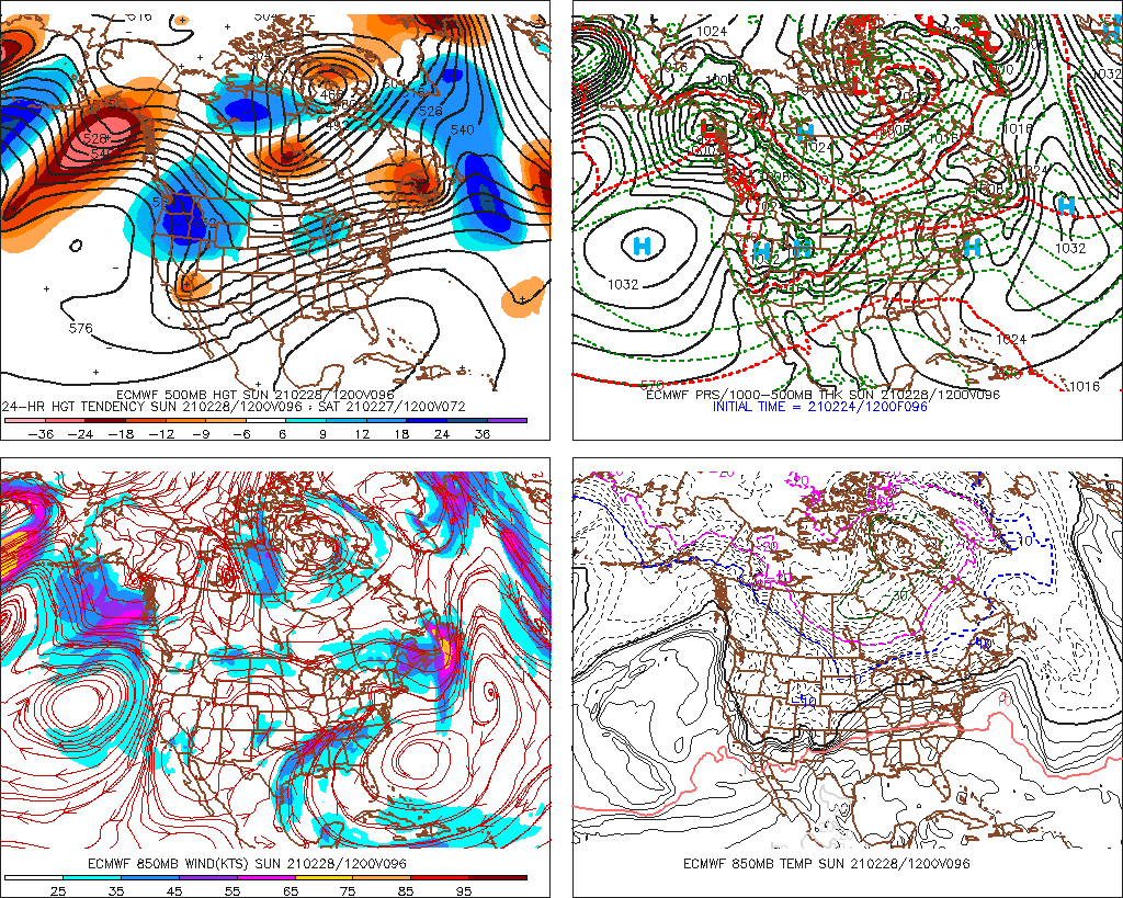
Yeah... it's getting increasingly more difficult to buy into the GEF's motif out there in time. It's hard because the operational versions have now recently come into sync all the way out to D 10 (save dumb details...) and if anything are even colder. Cross-guidance support for a modest +PNAP is out of phase with a modest -PNA. Ha... that would be opposite what the GEFs have been selling - for days and days I might add... F-it! it is what is. This seems to happen a lot in recent years... You wait and wait for the side that should start to capitulate, and then it only doubles-down. Then, what's happened was some a compromise in the verification tendencies.. Heh.. perhaps that the path of least required headache. Just some thoughts for the general reader below - Some of the things I've cited, I've been thinking about deeper ( because I of course have a life so fulfilling and enriched with spiritual utopia otherwise... ) 1 ... La Nina spring climate. It is not a 'weather model' of course - one cannot use climate to predict the weather in that sense. Duh, ... however, it does inform. If the climate was warm in the past, during or after similar indicators were observed ... yet, one is presently observing a cool look, that correlative information tells them to be on the look out for reasons that the present cool look might correct/begin to do so at some point in time. 'Correction vectoring' seems apropos. There were some strikingly warm springs that began in their March's, following ENSO distributions of this ilk .. antecedent to this spring. But here's the thing ... and the more I think about it there's no real getting around this: the general circulation eddy of the Pacific has not really looked very La Nina this year... It makes then attempting to apply a La Nina climate history a little dubious to me. One cannot in one hand admit something is not working out, and then expect positive returns in the other - seems kind of obvious, huh. In short, La Nina seems more represented in the oceanic SST/thermocline layout than one operative in the hemispheric circulation, thus outright spring climatology should come into question in any modus operandi. The other possibility ...well, 'plausibility,' that complicates the f out of this muddied array of compensating failures ( haha ...) is that the HC is still sort of arguably burying the effects of these ENSO's as the - to date - best estimating reason why there has been less observed coupling to the ENSO since 2000. NCEP is claiming the La Nina footprint this year but I'm not inclined to agree with them out of box. I suspect the points below are obscuring the truth, and since it sort of mimics the La Nina by driving enhanced Trade Wind/ SS Stressing, this is masking what is really going on - hard to parse the two apart, because the velocity is skewing. 2 ... Hadely Cell expansion, as is noted over recent years (decades) is/has been observable effecting global circulations ... 3 to 6 dm of residual seasonal heights that linger within the tropical 'girdle' during boreal winters, are causing the ambient gradient to increase. Perhaps beneath standard intervals for even anomaly detection .. but it exerts just as well. That is increasing velocity in the balanced geostrophic state. Velocity is intrinsic in wave mechanics... there's really no way to get around that (then) having some kind of influence in this debate... The application ( if not implication) here is highly speculative - but it deals with conservation of wind flux/mass-balancing. If this expansion is speeding up the interfacing jet between the HC and the lower Ferrel latitudes (i.e. 45 N), that simply has to change how the La Nina can effect hemisphere ... it's as good a starting explanation as any for the apparent lack of observed La Nina hemisphere at mid latiudes - could be a kind of false equivalency La Nina year. It's in the lower latitudes but it's being smeared above ... Meanwhile ... Euro weeklies and oh, lest we forget .. celestial mechanics. Mm hm. July is still coming .. Whatever happens, if we are going to get our sun's zenith to 71 deg tilt angle above the horizon by June 30, and it is only 39 deg elevation at zenith on Feb 25th... at some point we have to capitulate to the notion that winter is dying here... Obviously it is a bargaining games on when that happens .. but rest assured - Now, I haven't worked much with the Euro Weeklies in the past - only vicariously through those that do so in here to be truthful. I am aware they looked AN for March. And I thought when hearing that, "It couldn't hurt." But if the La Nina stuff is being blunted from voicing by speedy hemisphere, it may be that when the gradeint relaxes, it is allowed to express - maybe it takes longer. I mean shit ..we're trying to move a hemisphere's amount of atmospheric momentum here so.. heh, maybe it takes time to nudge that elephant. So, at the end of the day .. the operational runs should not look this cold but only get more cold ... sort of a wtf moment for anticipating spring behavior. As far as March... we are not in March yet.. heh.
-
Completely agree .. heh, I track 'nape' and spring balm days at this time of year like the Will - Ray apparatus does winter storms from Novie to ... well, July - lol...just kidding guys. But, Sunday has stuck out for few cycles and this Euro run really is the most impressive with it. ...Not sure if we can push 70 over a snow pack - it'll be interesting if we have one at sun up on the day ... seeing where that ends up ... But this has that look ( blw..), and would definitely do the season's first 70 F afternoon from midriff New England down if it were up to bare Earth... Maybe pretty mild up your way/both either way... This is 12z operational Euro inside of 4.5 days so ...it's got some confidence with continuity also adding to it - both. So, it starts out clear at +4 to +6 C ( +1 up your way ), we'll just have to see where the ceiling RH situates ...should be dry enough for mainly sun through 18z... And that "small bubble no trouble" high is perfectly situated for west wind delivering even shore points of E Mass some balm. LOL all the while, look at the cold air in Canada - yikes!

-
KInda weird ... sun and air with light wind at 51 F over a snow pack so white it strains the eyes even in sun-glasses ... kind of a dichotomy -
-
Fair 'nough - there is a NE. and there is a snow storm for at least some regions of CNE/NNE ... that makes it correct but... I suppose it is up to the reader not to be persuaded by "northeast" - when knowing full well that ignites a lot more regional expectations If it were me, I would have qualified that differently - just sayn' lol
-
True, but this is appears to be a R-wave anchored in the Euro - makes me suspicious that its typical conservation ( overly so...) of curved trajectories that model seems to collapse toward beyond D5 ... We'll see -
-
"..predicting a major snowstorm in the Northeast March 3-4? " That appears to be a "somewhat" inflated impression of what the 00z operational Euro really carries up into the Northeast with regards to 'snowstorm'. Stricter interpretation of the surface/ sensible evolution is wet snow and cat paws down near NYC ... with cold quick moving rain event around a zygote coastal low for everyone S of that... As the system then enters a bombogenesis curve of intensification out there as a low that move SE CT to Logan transit ...there is a blossoming MAUL/ converting to CCB mechanical look/transition, but that ends up more CNE and points N... .Impressive bombing rate of the low though as it ends up 972 leaving the GOM... But beyond that.. yeah, there could certainly be something in there and the above is just what I'm seeing of that one Euro run - not saying to ignore Euro beyond D5 with ampltiude though - who whoulda thunk ...
-
Wow, nicking 48 in very light wind bathing in unabated sun under Bahama blue sky ... on Feb 24 - this is 110% nape out there. Fake warmth incarnate - you could walk down the street in a t--shirt and think it's 60+ ... Let's see. NAM and MAV are both 50 to 51 at various sites today. Seems it's a good day to offer up a MOS bust - not atypical to do that in the spring uh... even though it is not even out of climatological winter. But I was actually surprised to see the MOS that high - I and thought for sure they'd be 45 .. yet we'd make 50 ...something like that. So it'll be interesting to see if they hit that. We should at least get to that high -
-
My neighbor puts rock salt in old socks, ties 'em off, and lobs them up there about every 4 foot down the length of the roof... He tries for 18" from the eave. That's more of an on-going maintenance thing though. Not sure about an immediate need. I'd almost take your garden hose and see if you snake it through the kitchen window, a Gerry rig it to to the sink faucet... Turn on the warm water and it's a 5 minute operation.. although - haha now that I think about it... nah don't do that. Cause the weight before the ice lets go may realize the bigger problem - My roof is more sloped. I don't know if that's specifically why, but I don't seem to have as much damming issue... uh, that I know of.. heh. I had a coworking once who didn't realize that the back water behind multiple years of ice damming had been flowing down the inside of his walls unbeknownst .. until the wall/and ceiling catastrophically sagged/partially collapsed... that's an extreme stroke of bad luck though ... I think they sell something like that though, with with the salt idea ... and it won't corrode shingles.
-
Yeah ...these are purely subjective takes on/comparison of them two years... So for what it's worth I think of Feb 2015 as an awe-inspiring pattern .... I think of a 1995-1996 as an awe-inspiring season ... Concomitant with both - in an attempt to offer some convincing logic to one's case: 2015 - the pattern was more locally realized. Not to understate/value... many of those locales pulled off almost scary monthly totals. It seemed also the heavy hitter cold was E of ORD ... 1995-1996 - contrasting, the season seems to have been a more ubiquitously shared experience ... really that's a broader inundation achievement than the 2015 year, which seemed to really focus for an intra-seasonal pattern gestation and focus in the E OV/New England, and probably was nucleus in SNE proper - though don't quote me. Another difference is that 1995-1996 did that three week Rossby rollout and repositioned a new L/W more in the Lakes and brought winter out that way tho not nearly as prolific ... Still, it was a spatially bigger layout in that sense, where S of Alaska to S of Greenland sloshed and a bigger zone of impact went along with. Planetary winter vs - So I dunno ..take one's pick. From inside a living room, you wouldn't know. It only matters to use dweebs -
-
It's true ... for storm enthusiasts, that February orgasm blue balled their March. I remember growing weary of it by mid month. We had been 10 days with blinding cold. I remember like nearly a week's worth of days, back-to-back, where mid day temp on the car's dashboard was always "19 F Outdoors" I'm like, March 16? 19 F at 1pm ... that's 4 days before the Equinox. Imagine it being September 26th and its 19 F. I wonder if the ground would be too warm to snow, lol. It was unrelenting and I was feeling like the show was over but the atmosphere wouldn't leave the auditorium ... ' fine, July is sill coming whether it wants to admit it or not' ...it still didn't really end there.. I think there was snow in some baseball stadiums into the first week of April - was that that year? I remember trying to watch a Red Sox game even after the season opening road trip toward April 7 ..and there was packing pellets and pitchers "warming up" in 33 F ... it was nuts. But through all that, it was wasted cold. Despite the remarkable and historic February, that year's silent record is really the 45 days of wasted cold LOL ...We could have had 500" of snow that year if storm rates maintained same with that bank-able cold ( edit, yeah okay so .. south of the pike there was still some activity but it doesn't diminish the point - you didn't get 120" south of Pike in March) Bit of hyperbole ( heh ) but I always thought that being that year's "leaving some on the table" - all the greats do. 1995-1996, I always wondered what could have been that year if Minnesotans didn't steal three weeks and four cutters worth out from under us rich greedy bastards back east. Jerks So ...to me, March 2015 was the real nadir of that "pattern storm" . Because from a broader Meteorological/ synoptic philosophy it is not the coldest break, it is when the instability is normalized and the set up enters a stasis of inactivity. That's the ultimate nadir because the 'storms' in getting there is still the d(pattern) phase... At the bottom, it rests... -
-
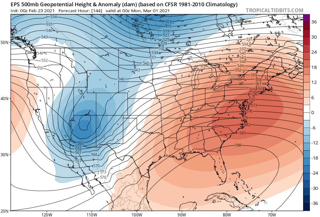
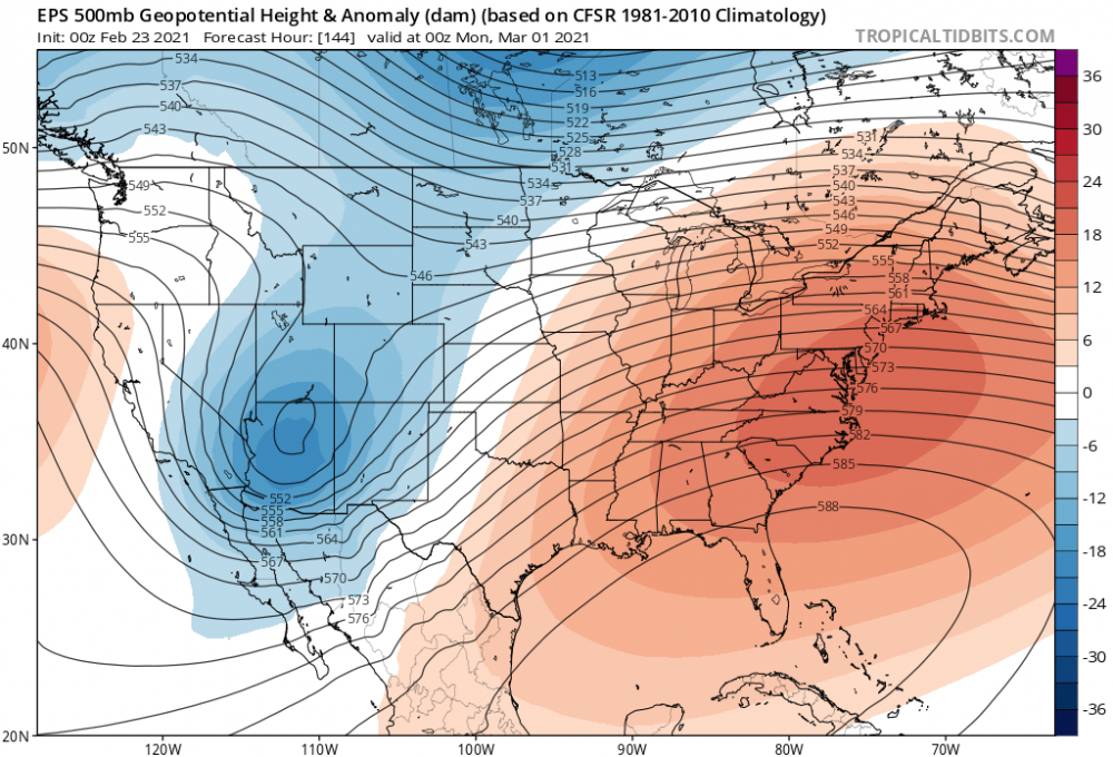
I'm wondering what the EPS' PNA curve looks like ? The GEFs ( as anyone can see if they bother to look/ keep track ..) has been taking the PNA to -2 SD between now at Mar 1 ...then, for 5 days ... it does send the curve through camel hump, concertedly among the members. After that the extended settles back blah blah. That hump doesn't quite get back to neutral ... but, it is a mode suggestion in there that sends "some"thing across middle latitudes of the continent ... even it ends up a non storm .. some kind of trough - it's just that the extent of it is probably not very anomalous, nor long lasting ... given the GEFs. But I'm wondering if the EPS might have a similar interim of PNA rise..only more robust? The Euro operational counterpart really seems to be honing that period of time with insistent +PNAP ( which is the actual over-continental expression with some lag off a +PNA ) but that layout is more so than the GEFs... I'm willing to hunch the EPS and the whole Euro cluster might be in a different bubble of ideas comparing to the GFS. For one, that absurdly deep cold shock event has backed off the overnight GFS runs, as others have assessed - not that we didn't suspect that would happen with its -99 SD trough that is physically impossible on Pluto let alone Earth - Speaking of the GEFS - the totality of the telecon spread between the majors ( AO, NAO, PNA ) are all still yet again insisting upon switching the hemispheric mode. It seems there is a recurring theme ...really going on for the past week's worth of everything godly and glorious in the technological realm of atmospheric modeling: Do not allow operational runs to ever look as warmly impressive as that teleconnector converged signal would fit. I'm so put off by the operational GFS's abysmal and embarrassingly coherent cold height bias ... I don't know what to think or wonder what goes into those individual members let alone the blend. For spring enthusiasts ...you still have La Nina climo which is a pretty strongly warm look. Thing is, it might be hard to parse that out with CC piggy backing.. Climate change is like an automatic decimals if not whole degree above monthly norm expectancy anyway. But these ENSO numbers look by both numerology and behavior spanning the last 6 months, similar to years in the past that had obscene warm spells nested in a three month mean that was well above normal .. The climate inference alone has legs. For now, 46 F at 9:15 on Feb 24, with sun equivalent to October 15 ( for perspective ..), and only light wind, and full gem-sky blue sun unabated to Kevin's shining dome ... while angels kiss his nape ... does have an appeal doesn't it .. heh. Anyway, today oughta bust MOS... We've officially entered the MOS bust time of year for these sort of nape days-
-
I dunno.. .thing is, that could tone it down by 15 deg and still be exotically deep and equally as annoying - assuming the latter is what Gaia's really after.. The Euro did carry a similar cold shot at least once in recent runs and considering we're not really in the Euro's wheel house ... It may all end up that we get a 32 F high and two cold nights, interrupting some AN afternoons out of that.
-
Yeah, that cold snap then it may get real hard in a real hurry if one is holding out hope in this hemispheric footing - it would take a fluke of the higher order. Could...and March is the kind of crazy month to do it.
-
actually the GFS does that itself - wow ...
-
I kind of want that to carve SW and coastal people within an inch of toleration ... then have the EPS launch us into the 70s 4 days later... White out to warm out -
-
Well there is... Even in that D5, 12z operational Euro depiction, which likely evolves the best plausible outcome for Sunday, there is a frontal structure extending from Indiana to Cape Hatteras.. It's one of these deals where the sun is strong 'ish now and getting stronger, and that Euro run places us so far N of the boundary that we can cash in on lingering modest positive anomaly at 850 mb thermal layout, with light winds under DVM probably keeping it on the sunnier side ...at least though mid or late afternoon. Agreed, that may be an optimistic outlier - ahh, on Feb 28th...just maaaaybe so huh? You have to forgive me - once we get passed Feb 15 every year, I track these early winter napalm, nape gem days like their actual snow storms before that time.
-
Hoho man ...pleezy weezie with sugar on top - after this f'n pandemic internment camp? Unfortunately, fragile as is... I was just musing in the other thread that the EPS is trending up the eastern latitudes with extent of the ridge under pinning... so that's good sign for spring enthusiasts. Otherwise, that set up has like no room for error or the boundary is too close and we be skunked -
-
well... not as is - maybe... Not quite Fox Hall territory... Again, I'd like to see the 576 close the gap on NYC. We all have our ways and means but for these early attempts at spring balm pattern looks that's sort of index finger rule for me personally... Shy of that cons into thinking utopia but delivers necks kissed by skies of drab shit spray weather - mmm sign me up! no thanks... close tho
-
I dunno... hard to ignore the EPS' trending that mid range SE height menace... It's not hugely incremental... sneaking up, maybe like 2 or 3 dm per 12 hour cycle... but should this get much more anomalous we're likely to just see that D5 through D7.5 or 8 end up SE of a wavy stationary freak frontal zone, se of which reside securely inside a dry continental spring conveyor of that deserty 70 F thing - relax ! It's not there yet ..but there's no part of the hemispheric present footprint of La Nina spring and teleconnectors on top that screams that won't happen just the same. I'd like to see the 576 get closer to NYC ... if/when that happens, that's when the operational run has 82 at Albanty lol
-
wow..this 12z Euro run on the 28th - last day of the month.... That is deep spring folks! ... +4 to +5 C at 850 mb with COL pressure pattern, < 50% RH at 700 mb at sun up... sun would bust MOS easily prior to clouding over mid afternoon - and it's possible the ceiling ends up evaporating on that front edge because it's running into weak DVM associated with that little-bubble-no-trouble surface high there. I love that stuff when the new season lays down the law type afternoon. Obviously it's not the defining anything else but that 12z D5 look is a pretty exceptional blue-bird day appeal. That goes right passed nape stage and into legit balm appeal there.
-
Heh... if it's windy no bueno tho - 'nape' only works if it's calm-ish and more sun than cloud. If it's so much at 51% instead of 50% sky coverage ...and the wind is at all noticeable ... the nape appeal is ruined. It really has to be that light wind and sear sun ...where a lazy stroll down ones street lies about the temperature. 49 is "63" ... so forth. Very fragile... I don't frankly like any wind unless it is associated with a Nor'easter, a tornado, a thunderstorm outflow... or the p-wave off a comet impact - otherwise, I find the bluster to be annoying and chilly right up the dial until ... ~ 85 F, then you steadily want more wind because ventilation is needed... But if 67 sunny day with wind bumping you around is a piece of shit day to me
-
you'd be surprised how many of intellects out there read that and its obviousness does not occur to them
-
Symbolically ... yesterday's minoring event appealed to me like a March thing. Today, sun is fighting through a milk sky and it's still managed 44 here. It's like with open blue it woulda torched MOS for 4 or 5 I bet... I thought tomorrow would be nape day #1 but I think that's today. Tomorrow gets to be #2 ...
-
Yeah agreed - ...mused snarkly a while ago about the GFS's propensity to lower cold tropospheric features too far as it is. I don't have a problem with a deep trough intrusion and a 'snappy' cold face smack ... but I don't know if we need Antarctic depths to do it
-
Haha ...yeah, a little voice in there when I typed that sounded something like, "...he's gon' jump on this statement I fear" ...I thought so? but wasn't sure. I figured it for less relevant either way. right