Typhoon Tip
-
Posts
44,568 -
Joined
-
Last visited
Content Type
Profiles
Blogs
Forums
American Weather
Media Demo
Store
Gallery
Everything posted by Typhoon Tip
-
Right... yup - my bad... NJ ... but yeah
-
I wonder if the March 9/10 ordeal may try to come back ... I could almost see it coming back - also - as a spring cut-off drifter over the W. Atl/ astride the EC ... too. I mean it's still way out there ...
-
Yeah...and it's layered - sorry I'm bombing you with replies ...just happened to be in the roulette timing right now .. lol But, I see this winter as being supplanted by the -AO ..which at times ...spanning some three weeks in late Jan into early/mid February... plumbed to -6! It was book-ended on the front end by another negative phase of its own; both of these nadirs negative towered some -4 to even -6 standard deviations. That is a helluva lot of implied exertion down to middle latitudes, ... I suspect in greater proportion modulating the hemispheric eddy into something that ... yeah, doesn't look like it was ENSO attributed. The problem is...with HC packed down underneath ( hyperbole..), that made for intriguingly weird scenarios where blocking rested at times over fast flow - that is a very highly unusual, and equally non-discussed characterization that took place a lot actually. But here's the 'layering' aspect. I don't know if merely removing the -AO would suddenly evince an underpinning La Nina characterization, either. We've had this discussion... I think the general even NON AO hemisphere ( as in normal boreal winter) heights .. pressing down upon the empirically proven expanding HC shit... that's been modulating ENSO 'efficacy' if you will in forcing .. even if we removed the AO I'm not sure the La Nina would be exposed because of the ongoing circumstance... I had mused/posited that the spring could flip more dramatically warmer ...at a minimum, definitively AN... whence the AO relaxed? That relaxation has come and passed and we are not seeing that happen. It's interesting... This La Nina is not interested in taking over...
-
Depends upon what one is using I suppose ... There numerical equivalence of the teleconnectors from CPC ... don't match the individual members If you go to PSU as a free, quick and dirty coarse review, and float your mouse over those members, http://www.meteo.psu.edu/fxg1/ENSHGT_0z/ensloopnew.html, individually, they don't look as warm as a CPC index site. Yet the latter keeps signaling spring Frustrating... particularly for someone like me, that really would like to comfortably get out of the house. But I'm highly confident that is more ubiquitously shared. Longish post beyond this point ... It's not the same as that bag-o psycho babble aspect of being moody and emotively guided by the weather chart cinema - not even in the same concept. Different subject... Strictly, this year is particularly and uniquely challenging coming into dreadful New England "spring" climate... There are four season on the planet, and since New England has three ...clearly, we are in hell and not part of this planet. We have autumn, winter, Caligula torture .. terminating into a summer stolen down to 10 minutes. Seriously, it has to do with a more normal, human response in any scenario where personal freedoms are being affected - whether for virtuous cause and benevolence aside. This pandemic shit is imposing based upon a catch-22, philosophically. But that philosophy is a damned good one! We've spent close to a million years in human evolution ... where/when freedoms "inside our safe zones" did not include these masks ... nor distancing ..etc.. We are not intrinsically adaptive for not having processed through any 'Darwinian' crucible there in - in evolutionary time comparison, this is like the time it takes to pick up a hot handle. It is therefor not in our genetics - literally that is true. What we do is purely a cerebral move, one that proves human ingenuity/brain-trust ...probably higher sentience and 'awareness' in general, have all outpaced Nature's normal 'testing' process of adaptation. It's true across the board. From math to Mozart, telescopes to microscopes, Quantum Mechanics to General Relativity, Genetics research, to deep field Astronomical Sciences and back ...these 'achievements,' what we are now doing both to our selves and the total Earth "Gaia" ... they are inherently in conflict with the "rate" it takes to get adaptation through those Darwinian gates. Thus, self- imposed ( 'species' imposing in this context) limitations on personal freedom are still just limitations on personal freedom. At the instinctual level .. the virtuosity and "experimentation" that is felt utterly necessary ...all that, is in conflict - nothing else. You know... a million years of instinct momentum ... c'mon. It's obviously gonna win against the conceit of of these limitations ... That's why for this 'soft revolt.' ... You can see it in the way society is sort of turning nose from the subtle aroma of hypocrisy going on.. States began alleviating restrictions when this thing was like 10 minutes past that monster peak 45 days ago... etc ..etc.. People are getting more sick of it than that which they fear - that usually emboldens through anger ... The inevitable, systemic tough shitness modality takes place. People are going to get sick and die, but the majority won't and it's getting precariously close to a scenario where the instinct will supplant this ideology that we can win against a biological force that has had 3 billion years to perfect its self. That's what these variances are from - btw ... They are the virus fighting back through mutation ... Eventually, they'll figure out a combination of DNA codes that gets by any vaccine ''fire-wall" and we'll just go through this all over again... We vaccinate for the Spanish flu ....every year, anew. They are called genomic ancestors: Influenza-A and Influenza-B ... Coronavirus is not getting defeated ... it's changing into something else. But, the upshot there is that they usually mutate into a less virulent forms - it doesn't ultimately favor a virus' pathogenicity to kill the host. Anyway... it feels like the Rubin 'The Hurricane' Carter's story, where he was wrongfully imprisoned by systemic racism in southern cultural Law, and they stole like 40 years of his life ... and every time we wake up and that Euro has pushed that D9 warm up out another day, and held the trough back and inserted another ( non-entertaining...) -20 C 850 mb cold dildo instead, it's just another in the innumerable failed appeal processes that proved insufficient against the systemic racist. Finally, ... after his life was all be claimed, an appeal succeeded... I guess that's our 10 minutes of summer in this dark metaphor.
-
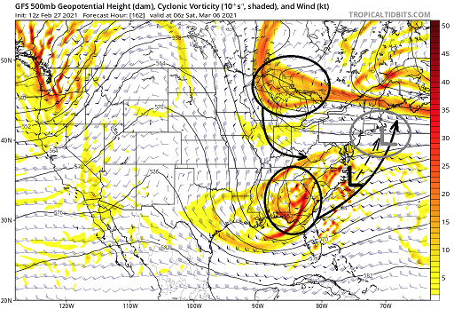
As a snap shot ? no .. obviously looking at that, it's well enough seawards to not matter. The risk assessing there at 162 hours out ... heh, it's close.
-
Haven't seen any other guidance ..so taken fwiw/ above ..that's something I've been warning swoosh in March - those "apprehensive" ...if you wanna call 'em that ... have erstwhile benefited from the fact that the various chartage has seldom if at all very much resembled either the back ground climate argument ( not CC but La Nina -rooted ...) ...etc.. not gonna run down that again. We'll see... I did just look briefly at the GFS... tries to destroy citrus crops again by sending bud-pusher weather up our way then collapsing into the teens way out there
-
The difference between tomorrow's dawn through noon versus Tuesday's is nothing shy of appalling!! my god - +8 C at 850 in laze faire westerly air, under partly sunny tomorrow -24 C at 850 in a cryo stung hell of 50 mph turbines on Tuesday w t f Talkin a 32 veritable mixing depth swing
-
Oh right, of course not... Yeah their thinking 'it's Ayer' ... good shot at a cold call hitting a mortgag as a credit risked, handsome interest rate saddled schmuck ... They're providing the easy way out. Nothing wrong with that... sometimes when I spending 5,000 on a new back roof, or 7K on new windows that required frame and sill work... new flooring ... jesus, it never ends..I've fantasize mailing the key the MP and fleeing to the tropical island and tending a teke bar. Houses bought up in this town some 10 years ago... 180 for a small ranch...? They'll probably throw 190 or 200 at you, you get out of it... They'll either raise the house and build new one for 75, 000 const. cost then sell for 450K ( now that the ring of speculation is in the area ). Or just flip it and sell and try 350K
-
Oh yeah... you know I was more than half joking way off the deep end... I just re-read that - have to pat myself. I was giggling all the way through that. Sometimes one's best writing is from the hip through a morning fog of lax inhibited, partial caffinated fugue. Can't hurt to have a distaste of disgruntling for humanity, either ... n'yuk No but yeah diet diet diet. Ray's actually right - ... I mean, first of all * duh * we're talking about vanity? Who cares over 30 ... well, 40 ... maybe 30s are in that gray area. But by the time 40 hits more are denying 1/4 of there chest hair curls gray and even found one on their nut sack and there heart skipped a beat. Luckily...it holds in that state until 53 before it gets much worse. But concomitant with those 'wisdom whiskers' comes an abandonment of denials and acceptance of one's stature and ... the working out? It's about 'feeling good' - feeling good about one's self. I mean excuse the Tony Robbin's babble for a moment ... if one is having a cosmic dong day and there are no determinably saddling aspect with a shitty physical limitation .. a work out does remarkable things to elixir that torment. Then, putting a nice salmon dinner with vegatables on top and waking up shredded ... it just seems to help - as one gets on and grows up, that's really way more important. And diet helps work outs so the two reinforce one another and the total gain...all that. And skinny dudes/girls can can modulate the body and diet is important ... if they have to work hard to get over genetic limitations, that'll help - As you are right also - by and large, know one's body type.. modulate a life style accordingly and you'll get there or some acceptable goal along the way. My particular thing is I'm probably 6, 3, 1, ecto meso endo in that order .. .maybe 5,2,2 .. but do probably too much of one work out type and not enough commitment to mass building to fairly complain. I 'm kind of full of shit on that part of it. Until I start doing Whey and Arnold note keeping on rep counts like those other jar heads in the gym I probably am just being assholey there -
-
Maybe yeah... 'cept , ha - 222 hours re a phenomenon that inherently is invisible if it is one of those, and has to sneak up as part of the the definition of what 'little critter that bites' means ( i.e., under-estimated) ... That advance notice torpedoes the invisibility requirement .. to mention, "little"? - trying to survive the tyranny of 222 hours of fractal-flow mayhem in La Nina battling God's for supremacy of which gets to break the most hearts ... probably doesn't end well for said little critter actually being there at that time... That said, yeah...in a vacuum that ignores all that ... it does look like that. Anytime a piddling system has a single physical metric that is unusually powerful embedded side an a dizzying array of nuances ... it stands a chance of over producing.
-
For me ... I find the notion of 'not grading until March is over', vs March looks unavoidably like a giant piece of shit across the spectrum of various charting and ensemble tooling ( telecon's ..etc..) combined ... as mutually exclusive realities. It's interesting too - because while neither of those are disputable, quoting Newton, "Two truths can never contradict" - yet being in this state of affairs apparently denies that conclusion. Maybe from that we can infer that one of those lead premises must therefore be false. ... My guess is that mood determines which ...? Yeah, if "healthy realism" is in play, ... giant piece of shit wins... and the former don't grade 'till March is over folk can eat said shit. If former turns/proves right, that invariably proves the 2nd premise of shitness wrong... Either way, it's almost like where "April is the cruelest month..." March should be dubbed the giant asshole month.
-
There's truth in this sentiment's essence ...whether hyperbolic or not - I'm 10 years into a home I never intended to live in this long. It's literally "over the tracks" - probably in both the trope dark comedy aspect, but is so in physical setting. There are 4 rails out that window, literally 150 feet over the road then a bit farther, not too well concealed by a brambling of shrubbery, bitter-sweet vine -strainied junk elm and maples, with typical strew of wind blown old plastic litter if also few vacated syringes on the thicket floor. This services both the Purple -line, and Freight traffic. They carefully negotiate ...using this area for a switch yard. Haven't yet witness a derailing or ( eesh ) collision.. but, .. given time, the cosmos assures everything happens at least once, with only one exception: I get to collide favorably with the woman of my dreams. In the meantime I await a loud 3 am banging and eventual bull horned pout of door to evacuate the inevitable chemical spill some day ... From elevation.. .there is a main double track line, skirted one additional on either side, extending west-to-east. The layout splits and goes south, an artery the 'real' switch yard mega facility ... down there in Worcester. West of here...I've bothered to geek it on the web..it appears the line connects to Amtrak out there around Great Berrington ... and also branches off to Alb/ Mohawk Valley .. others down to NY/N. Jersey industrial parks. The east one go to Boston ...and branch to service Maine it looks like. But it's shaped like a "T" ... so they seasaw and load quarter to half mile long train segments onto these side rail lengths, and then couple up and move them up and down to switch... And that means.. .my house..wobble and shakes like a 3.9'er any any hour of the night while they do that transitional two-step logistical activity with 100, 000 tons in both directions. Oh, and while that is happening... the commuter rail zips through at maxed urban speed allowance. I never visualize my life being stuck in station...having to be annoyed by that... But, I guess I could go down and ask those balled -head nine-year-olds of Dana Farber Institute what they think of an 'annoying life' - maybe not so bad... Sometimes at 2:45 a.m. one can be standing there in the darkened kitchen, scratching balls through a yawn and a glass of wee-hour water, when some motion draws attention toward the window. Under the street lamp it's some leg dragger moving slowly down the road like an extra out of a "Walking Dead" setting.. But despite all that ... I still have been suddenly getting bombed by cold-call texting and phone direct to messages... These are real-estate "venture capitalists" - I call them that, but I suspect they're just home flippers. - haven't returned any calls or engaged in exactly why they want to purchase my home for cash... but, I can only assume, whatever I bought this house for 10 years ago, they want to make it 'worth my while' yet ... still think they can make a profit flipping?? wow - It turns out that the "ring of economic growth and value" concomitantly expands from cities ..out, in North American economics. This process takes multiple generations, but as the slow moving 'fortune tsunamis' overtakes the erstwhile hapless denizen's settings, their virtuosity has no defense by the raw fearsome power of money lust that comes with that wave. That's all it is.. .a speculate greed wave. In the 1980s...it was just entering the Acton, east Chelmsford ...Wayland towns.... Now, it's expanded to and beyond Littleton and Boxborough across 495 ...and areas of Rt 9 between Framingham and Worcester up to Ayer and Tyngsborough ( although Tyngs. is hybrid Rt 3) are exploding in property value. That value is an outside -< in appreciation, though. You're sitting in a minnie-cape-sized drafty meth lab relic home in Ayer's mise-science of Military -base ( Devens ) abandoned economic dearth, in a prideful ( otherwise ) tedious blue-collar heritage, when suddenly your home is made double or triple the worth by pure random assignment. Winning the lottery in a sense I suppose. And the gentrification that comes with it .. has been transforming the setting of Ayer to be a sort of anthropological dichotomy of culture perspectives, political values, ... and education varieties. The wave effects communities differently - this has a bit a micro urban out in in the boonies heritage being sort of forced to progressive thinking. Oh, I'm sure in 20 years the transition will be complete and this will be another blue bird utopia petri-dish to grow the future's "affluenza" narcissists. I would take the offer... but I have no meaning for life any longer ...so I may as well rot here
-
And genetics ... In 'conceptual physiology' ( I just am less sure how these terms situate in sciencey aspects of the field ...) there are three baser body modes: Ectomorphic; Mesomorphic; Endomorphic. Ecto's tend to be thin/skinny/... 'wiry' as it were ... Think lean, type-a personality... "asshole" may leap to mind and in ( sad to admit ..) more times than not is an apropos description, if not in whole, something about 'em just worries people around them in a creepy vibe. They tend to get the job done and be goal oriented, tho..so there's that. But are often loathsomely lonely if not self-loathing and suicidal, - or, interestingly enough... giant woman tend to automatically end up with stalking crushes over them. Weird - Meso's tend to muscular ... balled muscle groups.. Pick up pencil, the next day ..the bicep is visible swollen with a vein snaking up its sinews. Interestingly... they can be glib and charming, and concomitantly with those attributable 'red flags' .. if ya get in there its pretty clear sociopathy runs strong in that genome like the force does in the Skywalkers - ...still, hats off? Even if one is not in the gym ballooning for their built in western cultural advantage, woman ( and some men ? ) still kinda sorta sense the magazine layout exist in there somewhere and that usually enough to the girl watching 'em to sit on their face anyway. Endo's .. unfortunately are not ever billed nearly as highly attractive as these "gems" above, in the modernity of culture/ .. western 'sexiness'. Think button nose .. round faced, 'animated Cabbage-Patch Dolls', wobbling around as stereotyped targets framed up in a "People Of Wallmart" book of comedy shade. But you know..life's not so bad - because this genetic signal has survived since primal era humanity, so somehow they're still getting laid. ... even if it takes a bit of imagination to figure out 'how' the fu that logistically can take place... Every person carries some amount of each in their total make-up. It's like each is ecto, meso, and endo gets a number value 1 to 10. Such that if you are 2 in ecto and a 4 in meso, ... you have to be 4 in endo, to sum up to 10. You could be a 1,1,9... or a 3,3,6... I guess you couldn't be a 8,2,0 tho... That's how the metrical analysis of physiological body-types is done I suppose. It's sort of like Horoscope phenomenon in that sense... If one is reading from the Zodiac bible... that 3" thick tomb that describes why no one really ends up with the girl or guy of their dreams, but ends up learning to enjoy the taste of gods shit and resolute to have had a 'good life' anyway ... it seems like you could be any of those signs - it's because you really do carry traits in all. It's just a matter of amount. No one size fits all - ... if you are meso of 6 or 7 ... and small beans in the other two, diet is only part. You simply don't have to work as hard to get your body to look like the monster ego-enraged boner that lurks behind your eyes and a diverging, god- given chiseled smile.
-
I blew it.... I thought we'd nape this bitch at least through 18z today ... but alas! awoke to the slate sky shits. Clear through 4 am, too, to make sure the radiative cold maxed, and the ceiling capped... to make busting that idea as proficiently as imaginatively possible too... It's like so murdered, that it resurrected the forecast ... just to rekill it! Thing is, hi res satellite does actually show that 6 to 9 hour clear area exists..It's just out over the warm nurturing waters of the outer GOM SW of NS - so I guess some minor face saving in that it was purely timing- otherwise we may has had that at sun up through 18z like originally assess three days ago.
-
I'm in the early 50s just E of y'all up in dem der hills ... I think I set at 52" ... which puts Ayer in the running for an average snow year. But we're risking it being on the cusp. If doesn't snow I think 10" more I'll end up neggie on the season. Probably owing to that December system shirking this region of NE Mass and SE NH out of ~ 10" ...that's the key turn-over that ultimately cost the Superbowl in that metaphor. Need at least average for a relative 'win' in that sense. But you're not that far from here up route Poop. I remember that Dec storm's post-mortem stats showed a dearth here that ramped up pretty fast just down the road a piece toward Fitchburg. From where I am up through NW Essex.. into Nashuas and the seacoast, the Dec storm was nothing more than hot cocoa muse out the window for a while. I remember the roads were handled and I was able to get to the gym and grocery run - barely broke routine. Meanwhile, banded of 30" raged on NW of here.
-
Overnight telecon subtle changes still give room for something in there - hyperbole aside.. Having not read any further along in this thread - my gut instinct portends a tenor where that song will be a lot of pissing and moaning however, as the operational runs across the board could not be more wrong relative to the most possible intents and purposes for this engagement - hahahahaha My god... why doesn't NCEP just admit that the entire Environmental monitoring/modeling division is a hoax? ... Oh they 'monitor' - the content of social media enthusiast 'atmosphere' of desires, and then create 'model solution's that injure the most joy as they can in a great Schadenfreude sociological experiment. What in the fu was that ? I mean, it is just pure wrong for warm enthusiast, and storm enthusias, and spring enthusiast, ... even winter enthusiasts. Because from my experience, with winter enthusiasm, things actually fu have to do anything at all ... other than brick the Earth and keep people imprisoned in their homes during a Pan-fu'ingdemic internment camp... Any plausible redeemable characteristic cannot be found in that guidance suite - does not exit - infinite wrongness. I wonder if that's actually possible? I guess the upshot is that since we're talking D5 thru ... roughly 13 of the guidance vision, that's supposed to mean that 'perfect' solutions won't happen - ha, like, 'unfortunately, the dogshit stuffing down throat machine solution won't happen because it D8' ... right? Ah hell... I see this date every year as a perennial right of passage ...it's right on the spring seam between the season going and the season coming,... where the models - symbolically - cannot decide which side gets fu the hardest ..so they just stand-by everybody in a cosmic dildo holding pattern for a few pumps... I mean, modeling cycles... LOL, inappropriate jokes aside, ... that was an obnoxious series. I mean the trough is opened back up sparing any passtime storm entertainment around us, but migrates up to 'faux' the NAO negative for 6 days... pushing cold out to mid month/ retarding the previous warming trends by like a week - all out of nowhere. The NAO curve at CPC shows a 'cupping' right in that time frame; sure enough ... looking at the individual GEFies ...they all have a 50/50 pig.. Interestingly, they don't much over-arc ridge/positive geo-p anomaly up there across the N. Atlantic - it seems local scaled NAO dipping there is more default by virtue of the vortex in this scenario. That's bad. It's bad because that's really "storm destructive" inference, because the flow represents post restoration/ .. thus balanced as it arrives into that state ... there's no where to go but a long prison sentence to get out of it while it winds down. Better hope for spring enthusiasts, NOT at the blazing speed of seasonal change. That means, no snow.. .rain. .. probably, shreds sun in soothing current of 20mph daily wind from Dead Horse Canada Meanwhile, La Nina spring and climo starts getting asynchronous officially tomorrow, with day 1 of Met spring and counting...
-
There’s probably a lot of different metrics for analog computations but the ENSO -to me - looks a lot like 1976 and 2012 .., Both those year did well abv normal MAM’s I’m curious how ‘77 and ‘96 are comparing. 1996 was neutral negative so there’s that. I don’t know. I think the HC aspects are also skewing everything too. Analogs are obscuring when the thens did not immerse in the circumstances of the now ... etc
-
there's the Crocus pusher pattern ... La Nina knocking on the door ?

-
i have the opposite issue body comp - man, i made a move 4 or 5 years ago toward a proactive life style commitment and holy hell - i weight 175 and i'm 6'2" i eat organic and fish and chicken ...rare red meat..and only complex carbs. no isolated sweeteners and rarely ever any general sugary shit. i don't drink alc. either. i'm trying to gain muscle but it just doesn't ... i only get more shredded. it's not like i'm weak. i curl 40s doing hammers and fly a buck -20. but just wiry i guess
-
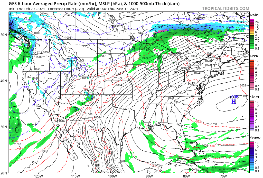
Ha... been jokin' with Will but I'm thinking there may actually be a chance at this .. A last of the season sort of hurrah exit event, then as little as three or four days later, spring tsunamis in... Even the GFS overcomes in N/stream mania to wash out the 540 blues after whatever comes of that... .. hm
-
Not getting swept away in this ...it's just as is, this GFS has motioned distinctly toward the 'subsume' model phasing... Getting to this set up at 162 hours in a slackening gradient -- > increasing entropy, is a bit of an undertaking so we'll see. Am aware that it is joined by a GGEM "trend" ... It's in that D6-9 window I was mentioning early so from where I'm sitting it bears watching.. Basically animating that above.. the polar arm/oval above Michigan rotates into/ .. captures the southern transiting SW ... notice the gap in teh 582 to 576 height contouring over Miami - that's critical ...because the flow relaxation is not asborbing that southern system. It's synergy - a stronger southern system injects more PWAT air/ dynamics for/when the N/ stream captures it then explodes in the classical model of how those work.
-
How 'bout now?
-
Sounds a bit like your impetus is solely in the MJO ?? I'd be leery of that - There's an ambrosia or reasons why an MJO anywhere from late phase 7 to early phase 2 around the RMM, would mean less for us here. The MJO does not drive specific events, firstly. I don't know what your specific level of education/experience/wisdom is, so taking fwiw - it sounds like you're intimating: MJO = big one Primer: MJO is a pattern enhancer. Crucially, it is dependent upon the surrounding hemispheric mode or it cannot really readily enhance. The erstwhile hemispheric circumstance has been out of phase with MJOs on the left side of the RMM as a seasonal-scaled issue. What that means is that any wave presentation currently displayed in that left region, are probably being damped ... In other words, if the surrounding hemispheric mode was supporting, it would be much larger and coherent as a curved trajectory around the side of the RMM. In short, because it is "struggling" in that sense, it's likely not really as able to enhance the pattern. More bark then bite - This is called "destructive" interference. This is actually been the case all season long .. where for some reason, the wave "wants" ( for simplistic brevity...) to be emerging on the left side, but the La Nina ( and probably HC expansion stuff ) are a hemisphere perpetually 'canceling it out'. Notice, we have seen almost no emerging wave strength over the last Phase 2 - 5/6 ranges, which is actually a "constructive" interference? It is interesting that there is no wave attempt/ .. origin over on that side ( as a separate matter ) Trying to sense how destructive vs constructive interference will augment the hemisphere is - to put it lightly - a bit of an artistic undertaking. But, when momentum is struggling to meet a measured value, that tends to imply that the achievement is being offset by destructive interference - so it likely doesn't represent much forcing. The other aspect is the apparent wave shortening and gradient weakening ... that means that any forcing that could remain...may get lost in the obscuring entropy of that breakdown.
-
I frankly have seen nothing that offers any specific focus of improved chances in the overnight. Basically still what we were looking at over the bevy of guidance yesterday. Although the CPC telecon tended warmer in the AO. The GGEM collapsed back to longer term velocity/progression look - not sure why I spend much time with this model as I do.. Only because it's bandied about by NCP ... AFDs and in here and I'm "sheepling" it. Maybe someone has some nsight as to its usefulness. But, it opened that phantom ( we suspected its falsity - ) trough and favors its extended toward lifting out winter. It sends everyone E of the Divide by S of the border through a Chinook processor and solid spring temp spread by D10... The Euro lags that by perhaps a day, but ultimately ends up there by reasonable error/~ half day...clearly extrapolating just beyond the end of that run toward a +8 F afternoon bath for the same area as a general theme.. The GFS has done what it always does between March and July ...every 5th cycle: instead of morphing the pattern steadily toward spring and beyond, ..it merely takes the average January 20th map and scales up in heights and thickness. oh god - we have to deal with that piece of shit antic all summer with V16 now too, don't we. In general the models look to me like they are being physically modified by two sensitivities: - lingering gradient richness and the same battle of extended amplitude failing to hold into nearer term progressivity/velocity gauntlet ... that is routinely wnning and damping those robust systems into pedestrian normalcy or less.. - seasonal curvature shortening/ .. flow relaxation is trying to kick in ...in the heels of that, so a bit of transition bug. I noticed this three days ago, and it's been getting more prevalent The 00z Euro's extended again picks up on this and the GGEM (ugh) now shows it too; the entire Canadian shield cold reserve is rather abruptly modified by a goodly amount in the sub 700 mb troposphere ...pretty much everywhere S of 60 N.. The deep -30 plumes are no longer loading off a flat -EPO quasi arc over the NE Pacific ( that was kind of unnoticed by the way...) over the last couple of weeks. cold relaxes..gradient relaxes... flow slows and buckles... that may open the the door for La Nina and HC to engulf the hemisphere * just a guess. Our entire scope of the hemisphere can flip in a hurry. I do think/suggest that through D7 .. 9 ... there is a pinch low potential, perhaps even one more R-wave integrated. And though the 2nd bullet above ... keep in mind, that is not intended as any instantaneous distinction. It may take a week or so after D9 ... gee, like March does sometimes. There can be bowling balls .. However, as that transition occurs, the R-wave anchored low chances drop "precipitously" beyond D9... and that leaves the rarer bowling ball climo dependency ... Anyway, summary: feels like the same sort of "maybe-ism" we saw during yesterday, for D6-9, was put on display overnight - so... maybe for storm/winter enthusiast, it's not taking away. I was hoping the CPC PNA coverage might show that bulge edging into positive SD... but if anything it went south by a quarter point. Still there though.. EPS notwithstanding... it trend more robust with western heights, but less with the down stream trough D7-8 .. negotiable Someone else mentioned 1997 April.. I almost get the feeling that although there is nothing specific that remotely resembles that at this time... this "feels" like the type of spring that would deliver back-to-back 67 F afternoons, with a 33 F blue bomb ... then 66 two days later. But that's just my mood at this moment.. blah blah...
-
I think I see what’s happening. the Euro paints the way on seasonal change on that 12z run. Not so much in the sense of wave spacing so much but the thermal profile up N across the breadth of the Canadian Shield substantially normalizes between D6 and 10 while going AN S of the border by the end of the run I suspect these buckling complexions are doin so because the gradient is relaxing. I mean it’s bowling season .. shortening wave lengths. it may also be partly why the western ridge /PNA are rising ... interesting. Chances may increase for slower moving marginal QPF loaded systems for a week or two. Who knows after but still waiting for L Nina spring to show up. this buckling showing up all at once though smacks more like recent years tho - recurring theme post velocity soaked hemispheres to do this in springs ... transition. didn’t end to well for early warm /spring enthusiasts. It’ll be interesting to see where this goes.