Typhoon Tip
-
Posts
44,566 -
Joined
-
Last visited
Content Type
Profiles
Blogs
Forums
American Weather
Media Demo
Store
Gallery
Everything posted by Typhoon Tip
-
Oh, haha...yeah... you should probably do a lot better in Worcester than Philly -
-
It's an interesting thing .. Two days ago we nicked 52 for a high temperature here in Ayer Mass per multiple home sites on Wunderground - so taken fwiw, but it felt that mild. By day's end although the snow was visibly less out in the yard it still had pack look to it... substantial with no bare areas....edge to edge...consistent all over town... Last night, however, that was even more visibly lost- ... yet it was only 41 for high clawing to get there in that nascent polar air. The difference was apparently the sun. Two day's ago, that "coefficient of nape-balm" was missing... lol. No but the ceilings were milk much of the day with tepid sun at times down to orb. Yesterday was thru cerulean blue and the snow on the south side of the house had crept almost half way down the front yard. Just something I noticed... That's why I wonder about the "this snow ain't going anywhere very fast due to density" argument ...heh. Empty an ice tray into the sink, run the cold faucet. That ice is gone in 5 minutes... I mean we get one coastal with thrashing mid 40s rain, I don't care if that's a foot of Italian ice...it's gone.
-
Well yeah...that, and prior to as well... That is why I implied it's not ending in 10 minutes, either I mean Jesus Christ - you can't even bring it up ... talk or lay mention to the inevitability of seasonal change? Holy shit. Not you per se ..I mean in general...
-
Well ... by the underpinning, insultingly obvious smoldering hope of the consensus .. that's supposed to be a good thing - Ha Somewhere buried in the skull of that mind set is a non-disclosing monologue about it 'still being possible' so long as its cold. Fact of the matter is, the engagement in here doesn't have much to do with science - never really has. And it is probably bi-polar for everyone to some degree ( no pun intended ..) or another during these transition seasons. There are times in the spring where the model runs seem to gang up on Celestial mechanics ( i.e., the Earth's rotation/angle relative to the sun and inevitability - ), and those times ...the model cinema drug users get a kick. Those times are bad for spring enthusiasts who've long checked out and long for the sights and sounds and aromas of summer - probably worse for these, too... Because spring in New England, I have come to find, is a psycyological challenge where "April as the cruelest month" is really more like "Spring is the cruelest season" ...anywhere E of the Hudson! Then, those seemingly rarer times when warmth takes over the charts and outpaces the calendar by several weeks, the pendulum swings the other way.
-
No... your sick of it, not because it has been repeated ... you're sick of it because your neurotic about holding onto winter and don't like hearing anything else. Sorry if reality NARCANs people's high. - the difference there is realism: an approach that requires one 'get it' that winter is ending ...whether it snows next week or not - enjoy that. I dunno, what - you hear that and process it to mean absolute - like in 10 minutes ? no - It's March... spring. Winter ends this month both in Met and solar calendars...
-
Raise your hand if you're up to here hearing this goddamn statement - lol It's alright - not you personally... It's just ad nauseam with that and most years since the beginning of the era of modeling environment utilizing tech ( say 1976 ), phasing beyond 72 hours is and was always such low dependability and that being 180 hours: IN spring IN GW IN fast HC poisoned shear shit show of a flow I mean 180 from now...what? Is that July 4th - may as well be. haha. I like the D10 spring explosion everywhere ... big big time warm front in Lakes...
-
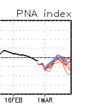
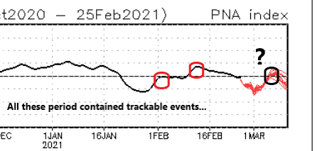
Am not sure I buy it just yet ... seeing as you asked and so cherish my input - lol. no seriously, there's a modality in the PNA that is intriguing coming from the GEFs ... Kind of insidiously innocuous because the curve doesn't actually go higher into positive .. but, the many members all are on the same curve... here, There are a lot of members buried in that nearly collocated curve trajectory ...so that actually lends confidence in a significant mode adjustment across that 5 or so day of that length of time there. I surmised awhile ago that the 'behavior' may be more important than the absolute positive or negative value - and I really believe so frankly ..but whatever. Anyway, the PNA is a huge domain space. It may be that the American ( PNAP ) aspect is more Euro-like, ...but the total Pacific and American domain is pulling the curve down... It's like we have to split the PNA into quadratures...and if so, the PNAP aspect would be greater. Regardless...that above for me signals there's room for amplitude...I'm curious how the heights in the deep south layout though - it could imposed so negative interference from that aspect too - Anyway, as far as that CMC run it almost looks like bowling season antics - which could work out in its own right but if it's not rooted in the above stuff in my be coincidence. And ...it's the Canadian - haha
-
Lol - 90% agree... If you change, "...Through April," to ..'through March...' By April I really don't want snow ever, period. Druthers and reality seldom agree though ...I'm living in the wrong part of the world from ~ March 20th onward. I've thought my utopia would be the girl of dreams at my side, and a second home ... well, 'bomb shelter outfitted to be home,' residence out in NE Oklahoma. Resettle there every spring from then through circa early June... maybe mid May pattern tenor permitting. Then, returning here for mid summer. And every autumn, we have the wherewithal and luxury to tour the world in travels to learn sites and cultural histories in subjects having nothing - thank god - to do with the weather... Returning in November, again pattern negotiable. Although, I might break and key the door in September if hurricane is nearing the PR climo key slot -
-
In any case ... It seems like no matter what salient point one makes regarding the weather patterns over the next three weeks, the emergence vector is always pointed up one's butt - f! It's frustring.. like there really some kind of "Matrix" to the cosmos ...and it exists for that singular purpose. Risking the no-win setup that suggests .. ha, the operational Euro seems like it is a vastly over-amplified version of GEFs PNA index, if one were hoping for cross-guidance confidence. The EPS blend at the free sites I've look over, it is hard to glean support for the operational version as the last several cycles have more and less supported - no clear trend. Maybe a little more amped? But the operational Euro looks like it's gotta be soaring to some +3 PNA. Hm, the Euro also tends to over amp flows in both directions beyond D5 ..it could all just be bs for that reason alone. Still, I would nod to the GEFs for having concerted ( agreeing...) members; en masse they rise and fall almost along the same PNA values. They are all tightly clustered around the 5 day bulge - I think that behavior is more important than the absolute value of PNA apex, ... I'm willing to hunch. One might focus too much on 'positive' or 'negative,' but it goes from -2 SD to 0, which is still an upward correction of 2 total SD mass. It matters in determining a higher impact threat, vs just a nuisance ordeal next week ... There's may be a kind of limit in how much that can amplify though - even with trending western heights. The entire region from S of Hawaii to S of Bermuda is higher than normal heights. It's a part of that same insidiously creeping ... over decades really, aspect I've been railing about and (hopefully) successfully rollin' eyes or readers, because clearly my ultimate goal is to irritate people... yeah yeah HC again but ..heh, unfortunately, reality whether readers are either smart enough, moral enough, or lucid enough to accept, is going to impose limits to the southern aspect of these troughs
-
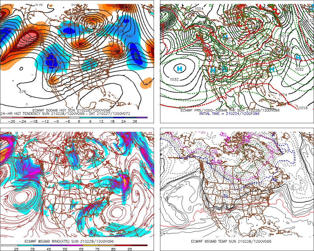
But what is the metric - all I see is a day, and colors... Okay ...so ( excuse I don't typically look at, nor have I been exposed to that product suite ) that's "ON D+11" - must be a snap shot of what it looks like on that day compared to historically? I don't see what/why "D+11" should bear any particular significance over any other day out in that range ... why day eleven? Must just be 'that's always been that way,' operational lineage thing. Not only that, ... looking at the individual GEF members, I fail to really successfully even imagine how the hell that day 11 from 12z yesterday, or last night's 00z ... could blend out to a that kind of .. what the f are those units in y-cor ?? 90 what? % above average? egh, not in the mood to root around in their labyrinth of online disclaimers
-
How ... and of what constitutes the determination for these CPC analogs ... Is it GEFS ... operational trend, the blend therein ... Any cross guidance? Is it all just 500 mb heights? what goes into the product. what metrics...
-
D10 .. you wonder what the tapestry looks like on D12's extrapolation too - that might qualify as a fair torch as that EC trough loses its footing and that western warm bubble bursts its guts downstream... It really is setting up for a big warm mid month in that look. Noooormally we don't comment on it? But erstwhile the CPC telecon spread bouncing the polar indices in the positive range, while the distant PNA slopes down...isn't exactly a bad foundation for that Euro run, either. EPS ? I'd love that - man... 28.4" yard stick storm then tsunamis warmth in less than a week later. ...yeah yeah prolly can't happen
-
Miami rule in effect too- If the PNA does spike a little more it might over come that.. but, the flow is fast while that SE is merely compressed in that scenario ... That's sort of what screwed the M/A in that 2001 March fiasco... I mean we could trend the western ridge better and dig more, and still have some neggie issues with interference from that region. Ha, it's like everything has to be perfect -
-
I wouldn't toss that entirely ...
-
I think Sunday sneaks in a naper prior to 18z ... still the Euro tries to sun up and hold back the cloud/sature-able ceilings for a bit, and with 850s still in the + 4 to +6 range it might spike to 60 before hand
-
This ... In essence, why I cringe at the very word, 'April' I mean I almost don't mind the 40s in March ? I never was a buy-in for that month anyway. I mean it sucks.. tru But I think because April is really caught in the seam where it's too unlikely ( though yes sometimes rarely ) to get a 1982 job done... or in 2005 I remember seeing blowing snow off a flat roof at 1:30 pm on April 9th or something ... Can't count on that tho... About as much as you can't count on it being 60+ dependable either... It's just like a waste zone and it can be 40 F mist days with gobbling into summer sun times too... Have seen that start taking days out of June and enough is enough, and it takes more. New forecast has a new BD ...like wtf ... thankfully, the plague springs are rare too. Not to happy about the last several Mays back to back... I feel like our summers ( and I am summer Met enthusiasts with tracking thunder and heat synoptics and so forth ...) has gotten bites taking out of it at each end.
-
Stupid to engage in that but no... the GFS is not "an inferno" wtf, c'mon people -
-
Lol...Kevin's reaction to that -
-
Yeah... maybe in the PNA a little - but it's bump out there in the late mid range does in fact not go posiive ..it only kisses neutral and collapses mid month. It may also ( lol ) help us not to use "torchy" and "nape" adjectives so liberally.... because they are subjective, and that allows bargainers and deniers room for tactical evasion and spin. ahahaha Kidding but beyond any hope from the PNA and plausible storm that may fall in that first week of the month ?? hmm ... hard to see where any AO and NAO ( respectively ...) bouncing around on the positive side of 0 SD represents failed napery. Lets define Nape weather once and for all. First of all ... who's the asshole that brought that term to the forum - oh ... wait. heh. Anyway, I'd say yesterday was about a B/B- nape day. It would have been a A, but we kept sheening milk skies...dimming the sun component - the sun is critical... together with light wind after ~ Feb 15 ... a cool day feels "faux" warm ... I call it fake days of spring when it does that. Razor thin parking lot warm layer in light wind and cold atmosphere.. It's an appeal, one that can't happen if sun or wind are outside margins of tolerance... So if we put quantifiable metric say, 44 to 60 F; post Feb 15; > 70% sun; light wind ... to score an A+ "nape-balm" bomb of a day requires hitting all 4 parts of that test I think with AO and NAO primarily positive in the GEFs ...and the PNA wildcard still edged negative ( despite the relative rise for that first week - which again...doesn't technically go positive anyway ) the GEF'll probably not only nape by the above criteria... but then what is a torch... hmm. I wanna say +10 F ...regardless... But, it can be 57 with too much wind and it sucks outside...and be +17 ... so maybe that is not good enough. Unless "torch" removes the sensible appeal entirely... and is just a numerical aspect. But I think +15 with > 70% sun and light wind as a baser requirement...
-
It has potential to amp more ... sure you're onto that - just sayn' The CPC telecon is suddenly quite concerted among the members, taking the PNA on a "camel bump" ride around that time. Technically not positive at the apex ? - no However, that can also at times be misleading ...where the absolute value of that curve is not as important as the modality/ and the complexion of agreement helps therein... So, that does offer at least a weak Archembaultian sort of correction event aspect to it - it's an evolving scenario. At first I was thinking the Euro's doing it's usual D8--10 day dreams of phantasmic cyclonic glory ...but it appears there "might be" ( we'll see where it goes ...) be some large mass-field signaling in play.
-
Man .. I have to be honest - this recurrent theme is like "Charlie Browning" events by the models ... It's probably been going on for years actually. It doesn't matter what facet one is focused, whether it be at the dystopia vs utopia end of the dial; it's been everything in reality in between. The modeling tech has over the decades come to create "faux continuity" schemes - then, removes them seemingly as though knowing when is the most nonsuspecting moment to pull the football away Lol. Seriously though - it's frustrating at times. It used to be, ...back in the 1990s, we looked for continuity in the runs. Simplest definition of that is ... does whatever one is following show up consistently from one run cycle to the next. The art then comes from sensing the trend to weaken or enhance ...etc...etc.. blah blah... But when you get like 8 cycles of storms by all models, and even telecon support ... wait until that much mass of consistency has taken place THEN pull the football ... it's interesting. Not sure if that's an artifact of changing and "advancement" of said tech .. or if it is a combination of their carrying on with modeling in a ..eh hm, changing environment
-
Yup ... for several cycles the Euro was flagging a nape utopia appeal on Sunday ...at least through 20z or so that afternoon ... But just when it comes inside the model's wheel house ... it pulls the rug out - maybe it'll come back
-
I'm not even sure that 192 hour, 00z Euro is worth the time to even call it a "potential" Doesn't seem to qualify probability/ .. determination enough to think of it as much more than phantom deep field Euro crap
-
Yeah... it's getting increasingly more difficult to buy into the GEF's motif out there in time. It's hard because the operational versions have now recently come into sync all the way out to D 10 (save dumb details...) and if anything are even colder. Cross-guidance support for a modest +PNAP is out of phase with a modest -PNA. Ha... that would be opposite what the GEFs have been selling - for days and days I might add... F-it! it is what is. This seems to happen a lot in recent years... You wait and wait for the side that should start to capitulate, and then it only doubles-down. Then, what's happened was some a compromise in the verification tendencies.. Heh.. perhaps that the path of least required headache. Just some thoughts for the general reader below - Some of the things I've cited, I've been thinking about deeper ( because I of course have a life so fulfilling and enriched with spiritual utopia otherwise... ) 1 ... La Nina spring climate. It is not a 'weather model' of course - one cannot use climate to predict the weather in that sense. Duh, ... however, it does inform. If the climate was warm in the past, during or after similar indicators were observed ... yet, one is presently observing a cool look, that correlative information tells them to be on the look out for reasons that the present cool look might correct/begin to do so at some point in time. 'Correction vectoring' seems apropos. There were some strikingly warm springs that began in their March's, following ENSO distributions of this ilk .. antecedent to this spring. But here's the thing ... and the more I think about it there's no real getting around this: the general circulation eddy of the Pacific has not really looked very La Nina this year... It makes then attempting to apply a La Nina climate history a little dubious to me. One cannot in one hand admit something is not working out, and then expect positive returns in the other - seems kind of obvious, huh. In short, La Nina seems more represented in the oceanic SST/thermocline layout than one operative in the hemispheric circulation, thus outright spring climatology should come into question in any modus operandi. The other possibility ...well, 'plausibility,' that complicates the f out of this muddied array of compensating failures ( haha ...) is that the HC is still sort of arguably burying the effects of these ENSO's as the - to date - best estimating reason why there has been less observed coupling to the ENSO since 2000. NCEP is claiming the La Nina footprint this year but I'm not inclined to agree with them out of box. I suspect the points below are obscuring the truth, and since it sort of mimics the La Nina by driving enhanced Trade Wind/ SS Stressing, this is masking what is really going on - hard to parse the two apart, because the velocity is skewing. 2 ... Hadely Cell expansion, as is noted over recent years (decades) is/has been observable effecting global circulations ... 3 to 6 dm of residual seasonal heights that linger within the tropical 'girdle' during boreal winters, are causing the ambient gradient to increase. Perhaps beneath standard intervals for even anomaly detection .. but it exerts just as well. That is increasing velocity in the balanced geostrophic state. Velocity is intrinsic in wave mechanics... there's really no way to get around that (then) having some kind of influence in this debate... The application ( if not implication) here is highly speculative - but it deals with conservation of wind flux/mass-balancing. If this expansion is speeding up the interfacing jet between the HC and the lower Ferrel latitudes (i.e. 45 N), that simply has to change how the La Nina can effect hemisphere ... it's as good a starting explanation as any for the apparent lack of observed La Nina hemisphere at mid latiudes - could be a kind of false equivalency La Nina year. It's in the lower latitudes but it's being smeared above ... Meanwhile ... Euro weeklies and oh, lest we forget .. celestial mechanics. Mm hm. July is still coming .. Whatever happens, if we are going to get our sun's zenith to 71 deg tilt angle above the horizon by June 30, and it is only 39 deg elevation at zenith on Feb 25th... at some point we have to capitulate to the notion that winter is dying here... Obviously it is a bargaining games on when that happens .. but rest assured - Now, I haven't worked much with the Euro Weeklies in the past - only vicariously through those that do so in here to be truthful. I am aware they looked AN for March. And I thought when hearing that, "It couldn't hurt." But if the La Nina stuff is being blunted from voicing by speedy hemisphere, it may be that when the gradeint relaxes, it is allowed to express - maybe it takes longer. I mean shit ..we're trying to move a hemisphere's amount of atmospheric momentum here so.. heh, maybe it takes time to nudge that elephant. So, at the end of the day .. the operational runs should not look this cold but only get more cold ... sort of a wtf moment for anticipating spring behavior. As far as March... we are not in March yet.. heh.
-
Completely agree .. heh, I track 'nape' and spring balm days at this time of year like the Will - Ray apparatus does winter storms from Novie to ... well, July - lol...just kidding guys. But, Sunday has stuck out for few cycles and this Euro run really is the most impressive with it. ...Not sure if we can push 70 over a snow pack - it'll be interesting if we have one at sun up on the day ... seeing where that ends up ... But this has that look ( blw..), and would definitely do the season's first 70 F afternoon from midriff New England down if it were up to bare Earth... Maybe pretty mild up your way/both either way... This is 12z operational Euro inside of 4.5 days so ...it's got some confidence with continuity also adding to it - both. So, it starts out clear at +4 to +6 C ( +1 up your way ), we'll just have to see where the ceiling RH situates ...should be dry enough for mainly sun through 18z... And that "small bubble no trouble" high is perfectly situated for west wind delivering even shore points of E Mass some balm. LOL all the while, look at the cold air in Canada - yikes!