Typhoon Tip
-
Posts
44,492 -
Joined
-
Last visited
Content Type
Profiles
Blogs
Forums
American Weather
Media Demo
Store
Gallery
Everything posted by Typhoon Tip
-
Lol, ... yeah my bad. Too much baggage; didn't read - call it 'tmb;dr' The gist is 'what's the use'? Just offering some personal shit as to why I figure for it having no meaning and in fact .. no use. You know, no one is taking this money with them - you're pathetic spending any life-energy at all amassing meaninglessness. Fascinating really - hahaha.. . some truth to that, though
-
The nape-bake rating is very high ... the only thing to holding it shy of 10 is the annoying like breeze. If the ambient T can bath a 64 ...that would offset the breeze and become less annoying. But at 58, on the edge. The sun is very hot and intense now though. We are passing through the front boundary of the 'solar maximum' - ...I've commented/waxed about the solar minimum in the winter. This is this the other end: May 8th to Aug 8th contrasting Nov 8th to Feb 8th ... with the in between the transitions. It matters... Going forward, a cold morning heading into a slackening wind, open sky day will nape-bake a fake consolation. Like Scott was saying, sunny days over the next shit weeks will likely do this ... and at least give the prisoners conjugal visits - LOL. Lower elevations down here will do better, too ...when the d-slope etc...
-
I have an opportunity to sell, get out of this mortgage. Even clear enough profit to reduce my lingering bloated school loans, if not to zero squarely in 'who cares' range. I just don't have anywhere to go and no reason to go there... I bought this small house for metaphoric nickels 10 years back ( relative to what houses typically cost in this economic neck of the woods/Massachusetts west of Boston). Here in the future, the market has up and appreciated like 150% ... I mean, 300 buck homes are now 450-ish here - and new ones built in the last 2 years? -wow I get cold calls and text from - presumably home flippers...- that want to do precisely that: purchase the place outright, no questions asked, for cash. The plot of land is actually modestly outsized for the size of the house. It probably is an attract lot to raise this beyotch and refoot and build anew, then... duplex the f'er and charge 1800/mo to keep a young starter family's echelon suppressed by taking too much of their wealth to save while they survive. Lol... Gotta love the gaping maw of rental economics - dumb. Because I paid light for this place... fairly confident I could double what I paid into the place, and get a chunk of financial soul back. But again...not sure any of it matters... I'm having all kinds of existential shit going on at mid age... questioning the philosophy of existence type crap. Like, so what? - we all do. But I'm not depressed in that tripe sense. It's the math of it all: in 40 years we're all dead and none of this matters ... Finality is absolute, and the absence of absence is the ultimate equalizer. Humanity, Earth, ...the sun and stars seem infinite, but are too finite... and the individuals that make up the other end of that list? We do not even register on the same scale as the other. But we flint as fire-flies, extinguished by the inevitability of the night... Be that as it may, gee, for some reason... sitting upon a precipice gazing out at an auburn sunset sky, with one's soul mate at one's side just seems utterly infinite in true wealth to me ...
-
Goes against everything ... 100% anti correlated yet happens. lol Kidding a little of course but that’s pretty weirdly going after a complete 0 redeeming value .. I bet it’s not that bad. It’s just like looking at a bomb on the day eight or nine Euro in the winter when the solution is perfect ...you know it can’t hold a perfect solution. And well the same logic should apply ... can’t hold a perfectly bad solution either
-
It challenges the endurance ... 8 days of that [apparently] impervious to thermal physics air
-
Nothing screams La Niña spring like this
-
Drought is over billed so the U.S. DM can keep their jobs. They’re biased
-
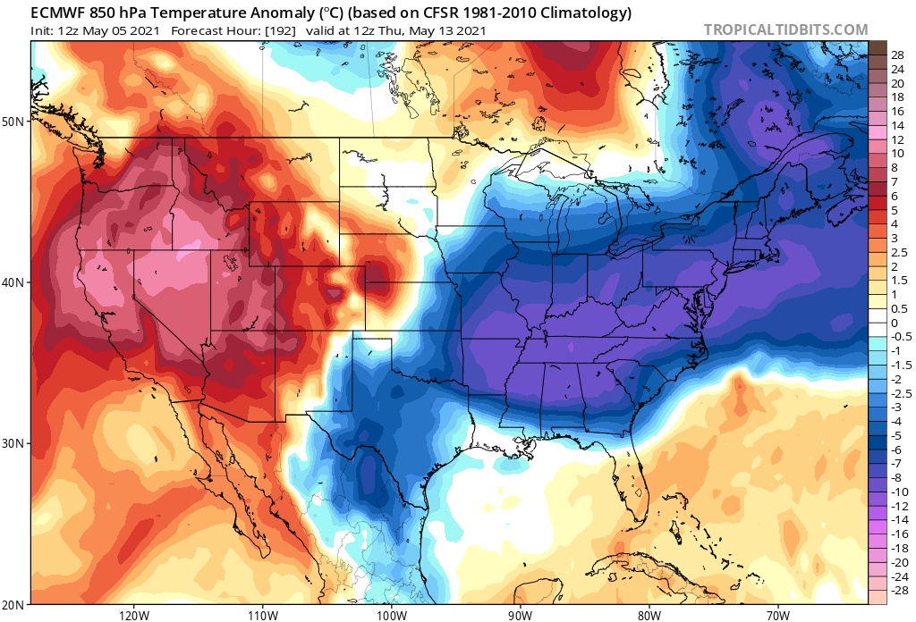
Remarkable ... 12z Euro has a massive eastern N/A negative anomalies at 850 ... deep enough to really to support snow actually, starting in 24 hours and every single day at 12z right out to the end of that run - doesn’t go anywhere ... doesn’t weaken.
-
I used to think the surge in appreciation was that affluence expansion ring phenomenon, slowly propagating west of Boston ... In the 1980s, it was out to about Acton, Sudbury ...then it made it's way to Littleton, Shrewsbury through the '90s and now deep into the 2000's, Ayer and down to Sutton and the towns surrounding Worcester and some of Worcester itself. But now I'm not so sure - it seems to be an American economic modality? Guessin' ... it may be more attractive to sink wealth into real-estate, because people "sense" a sort of ... not just volatility but really like vulnerability about financial industry handling... ?? Not an economist but as an observation, perhaps a combination of factors... Like 1, there's an after-taste after 2008 ( which ironically was credit swap debacle that started with over-valuation of real-estate ..). 2, Climate Change and green industry arrival not just threatening to crowd into the Fossil Fuel-based commodities frame-work, it kind of has to? Like an 'or else' pall hanging over everything. It seems that people more than ever just don't trust at a social level - which is a problem at a cultural scale anyway...- but that also extends tentacles around economics, which is in fact inherently a social construct so .... I don't know why, but it seems there's more than just the ring of affluence phenomenon ... Interesting. Anyway, I bought small house here in Ayer. 2 bedroom, 1 bath, kitchen and living area. In fact the laundry is part of the kitchen. I mean any smaller it'd be a "tiny house"... Big lawn though... I guess if I scored a windfall I could raise the place and there's enough space to put in a new foundation and bigger footprint, and still have a couple of box gardens... blah blah. But I get texts and phone calls occasionally probing to buy my house cash. They don't talk dollars ...just that they want the house. Probably to do just what I said, I'm guessing. Get me out of here, raise the place, ...put in a new one for 500K ...and they'd clear 100 after the dust settles... I was told that the appreciation here in town is 38% in the median, but nearly doubled in some the gem neighborhoods.
-
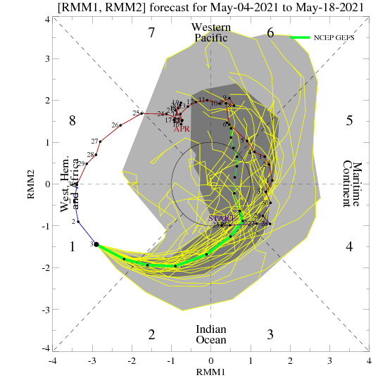
This might be related to why there is that 'dip'/+PNAP look across the continent .. Personally, I have to go back several years really in mind's eye to remember anything close to that magnitude, not just in wave strength, but it's longevity as kind of sub-metric is really quite ominous. A phase migration that is extraordinarily powerful on the left side of the RMM. Hard to know for certain if/how much that is related to the non-sustaining warm look and these blue thickness dyes cast on charts ... seemingly out to the end of time unrelenting, but it fits. It definitely should correlate more so in DJFM ...April and May? yeeeah, should less but there are super factors that are related to CC ( I suspect...) skewing matters and I think it's sort of "non-linear constructive interference" which I'm sure no one has a clue what that means so I should shut up Either way, for warm enthusiasts, that's an ugly magnitude/space in this graph below. It's even hinting at rotating right back out into another pass out there, too so it's like the hemisphere is trying to arrange a shit summer ...lol. oh man - Arizona is starting to look ever more attractive
-
Do you guys belong to any Econ -based social media platforms ? heh
-
It’s fun listening to Will and Phin’s presumptive cynicism - refreshing lol awesome I wrote about it earlier but of course I ended up getting carried away and loud I still think anybody investing in cryptocurrency is taking a Darwinian chance. but if people can’t see the future in this I don’t know it just looks like an easy vision to me ; eventually it will try to abase the real system of commodity-based substantiated economics and that’s going to end it pretty fast. ...regulation nightmare ... investors fleeing and it’s values just going to plummet to where it should be which is zero. Actually there is one other possibility - it gets too big and causes a crippling global row to untangle because the feds are falling asleep everywhere and it’s just gonna end up causing a complete socioeconomic catastrophe ...
-
Yeah, I know I've mentioned this in the past ...But it's just another social construct, an illusion of value that is purely invented and so everyone involved merely wants to agree it exist. We say oil and gold, lumber and paper and ...well, commodities have intrinsic value and they do; but even in saying so, those only do to those that think they need them.. Ask an Eskimo, with lamp lights burning seal blubber oil, and their cultural/provisional model based upon mastery of survival via other means than western cultural perception of need, ask them what has value. They'd blow their knows with t-notes while they explain to you how CC is destroying their means to survive. ( Sometimes a "proverbial" comet impact and dose of humility needs to happen to drive humility and most importantly, reality .. back into the awareness arena... But, commodity -based economics is way, way far more substantiating the value a dollar than anything that crypto crap represents. ) Know what it represents? Crypton. That's what! = 'crypton to any commodity based economic systems' The reason I'm mentioning this is because I agree with your bold - it's spot on. I mean the "volatility" you mentioned in the previous sentence is merely predictive via crowd physics' - that's all it is. If one has some sort of special gift or talent or insight into how waves ripple through the dunces they may come out looking like the head of the class - but at what? What I find peculiar, how in the f* is a vapidly unsubstantiated and not really footed in commodities arbitrary system, getting people laid? - that's transferring one economic system that at least tries to make the illusion more physical ..into a "fake" system of value - it starts taking value out of the substantiated value side, because of abandonment ... right? That reeks of break down in social order frankly, and that's a problem when economy's abstract purpose for existing, stitching/organizimg culture together around a common them, is no longer agreed upon. Doesn't that begin to come unraveled? I think it's probably demo-able in the math of it .. Economy is not my bag, but... I wonder: is it just a matter of time before the gov or some oversight necessity/org/agency steps in and regulates the shit out of it to stop it from sucking value from the substantiated side... sending the investors fleeing like the sky-filled-with-bird scene in Day After Tomorrow. And all these people that have 'real' money invested will get left hold a bag of dog shit when any real currency abandons and the emptiness gets exposed ...
-
Now enters that Twilight Zone phase where the satellite vis imagery illustrates marked improvements in ceilings that never are actually in the sky when one looks at it from the ground -
-
Timing of this warm frontal wave and spooge rains could not have been more perfectly timed wrong - SE NY probably cashes in on sun shine here over the next hour ...and high sun angle and longer days of May, they may even salvage... The rest of us probably get some sort of semblance of partly cloud and sky lights after 4 or 5 pm when it's seemingly perfect to rub it in - So long as the main ballast/mass of the mid tropospheric westerlies remains S of our latitude, we just cannot depend upon sustained warmth ..
-
nope
-
I must have a stomach like a billygoat I just had about quart of marinara sauce bathing a sauté of kalamata olives, onions, jalapeños ... garlic and mushrooms and green onions and shrimp. Obscene Italian spice in tablespoons ...Talk about acid ... polish the chrome right off a trailer hitch nothing.
-
That’s why I said lol nice
-
holy christ with that link ... i had to recharge my phone to get the bottom of that
-
Like ... not everyone can be rich. Tell you what! Let's create or own version of money and abandon that one - yeah...let's do that.
-
That was funny ... Yeah... depends on where the vagaries of wind aligned the clouds I guess... Pike to Rt poop down this way is in the wedge of partly sunny, in a slow moving overall synoptic evolution ... so we're probably are going to just get richer for the afternoon. It's 71 to 74 here in town at all home stations and frankly a walk down the street and back confirms that sensibly. Sky is pall blue with alto strata fractals dappled. Very light wind with hints of neighborhood lilacs and enough sun to add nape bake to the air - it's really hard to concentrate type stuff. It's warmer than yesterday, too -...not only surprised me that it got this way but it's adding LOL Guess interquartile statistical density ftw, huh Agreed Kevin... I don't think we are getting out of this week without some spring schmoots though. Frankly I'm okay with rain after three dry days.
-
Sneaking in an unpolished gem day going here... Must admit, a bit personally surprised. I figured today might be dry but zippo sun. We have actual sunshine in between day -glow skies and the temps over 70 ... I was talking to Kevin - I think it was - the other day that it would be interesting to test the NBM MOS ...which was putting out 65 to 70 F across KFIT/KBED/KASH/KBDL .. Even it seems to have busted slightly cool. All the while, the NAM actually looked like a better fit. I mean ...considering our sore-butt climate in early to mid spring, we are N of the warm boundary with an ESE drift on May 3 ... that's usually 53 F shit sky and tolerable chilly.
-
I feel ashamed every time I turn the starter and settle the wah-wah to hear the purr of the internal combustion engine's toxic fart factory's slow poisoning dose-contribution of the hour. It's just something we don't consider - like ... "flying" to a destination and then "riding" in a cab, to an auditorium that took a giga ton of carbon foot-print to power all aspects of overhead for ... just to rail as an environmental activist about a fossil fuel driven society. We are walking talking and "breathing" ( puns always intended just because I find pleasure in being annoying...) balls of toxic hypocrisy. Hypocrisy more than anything else is the lubrication of society. Like ...pounding away on a key board connected to the WWW ... to rave about the pitfalls of an impersonal social medias tearing at the fabric of culture. Most vegetarians ... they don't seem to be aware that they can be that way because they are couched in a societal machinery geared along by the majority - the enemy blood thirsty cheeseburger mongers. That's a particularly "delicious" hypocrisy right there - that whole holier than thou bag of shame and shade about eating meat. I guess if the majority cogs in the gear box decided to go vegan... maybe, but that wouldn't suffice the caloric needs of 7.5 billion mouths to feed - a purely agrarian species from orbit ... heh, probably in some super advancing counter-supplemental technology whence we are not there yet, that might be possible. It is an advancing environmental science problem but intuitively .. trying to turn the daily page of Earth's humanity on farming likely does not provide enough ... When it takes a 2 acres to raise a cow... that balloons to a requirement of arability land for growth that exceeds availability.. Animals concentrate nutrients into packets for redistribution - as coldly metallic as that sounds, it is a true. And then when aspects of climate and climate change get in the way... and crop vitality is not as dependable as the nutrients packed in Tenderloin, it just doesn't map out as very realized. Out here in reality, the point is, vegetarian cannot do this alone. Meat eaters can. It's called a gun or arrow, and camouflage. But most can't - hence the creation of Industrial abattoir scaling. That form and structure provides the provisional access convenience that delivers unto the moral high road's plate, the calories they will need to ablate our value as human beings for not being as morally priceless as they are.. Isn't that special - And on and so on.. You know ... despite all religions of the world and vicissitudes of history ... there is only one commandment that has prevailed for a million years: hypocrisy.
-
People want snow and that's their bag ... it's all good - I just want precipitation to fall in copious surpluses ... We need the water - that's just intellectually responsible pragmatism. I hope a Nor'easter drops the liq equiv or 4" pan dimensional in scope and scale, sending the usual problem streams and mid size rivers across Little League ball parks. just so the minoring flood event is in situ while the U.S. drought monitoring has moderately severe drought... ha. Anyway, we'll need the water JJA ... unless we get into one of these unusual summers of cool pool/trough convection like 2008 you know ... I don't necessarily trust the U.S. D.M. approach to regional climatology when/in their assessment of drought severity. This is not west Texas or California here. We definitely have a faster correction frequency than those environs of western North America's PNAP shadowing... It is almost impossible to sustain desiccating anything here... I'm sure there have been those eras in the past .. maybe even the like of which could rival, but .. we probably need - I dunno - something like 700 years before we return some scenario where the Quabin Res drops to church steeple exposure and the coffins bobbing ...