

Typhoon Tip
-
Posts
44,568 -
Joined
-
Last visited
Content Type
Profiles
Blogs
Forums
American Weather
Media Demo
Store
Gallery
Everything posted by Typhoon Tip
-
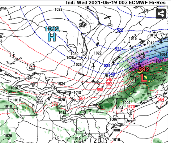
On the fence with that ... Both the operational Euro and GGEM depict a very interesting sort of anomalous pattern of behavior with that 'big bubble no trouble' polar high pressure that depresses the boundary S by 12z Monday. Both show the high pressure as dispersing and even splitting it's mass by 18z ... leaving residual mass NW NE and S .... Then, oddly ..regathering sort of en masse SE of Cape Cod between 21z and 00z late Monday afternoon into evening. I think that behavior is the diurnal heat modulation of the atmosphere overcoming the high pressure cell ... Heat and buoyancy forcing chops it up. That high pressure is also in the process of having it's governing mechanical support rapidly abandon it over the course of the day. There is no CAA ...only sun ( Zool!) The flip-side of all that conceptually is that those physical modulations don't happen without a temperature response in the interior... Those 925 mb temps/adiabats 'll get obliterated by sun by 11 am, and with no supportive CAA at all at this time of year not sure how the boundary layer is dictated by that level-metric. That's an easy call for me - Anyway, that saga offers 'late high' scenario for the eastern zones, because after the wind dropping to almost nill mid day with instead hours of unadulterated 73.5 deg angular insolation submerging the land mass in irradiance ...the pressure pattern evolution suggest a west wind takes over during that 4-7 pm period...and that busted air then moves east.. NWS is not parsing apart the nuggets of these behaviors nearly as detailed as I am ...
-
Just my cynical hot take ... but, the price bounce across the board of all these 'society scaffolding' commodities is ad nauseam predictable and frankly ... reflects a species that not only deserves a Pandemic ...they could use a Carrington Event + a Super Volcano concurrent in the same week of the same calendar year.
-
If there is a heaven ...and I make it in ... my version of it watches as CNN's dissolution sends a diaspora of ethically challenged cockroaches fleeing for the hills being chased by a karma cloud of misfortunes, both physical and mental/spiritual ... so incomprehensible torturous that god him/her self just chalks off as the one anomaly that cannot be constrained -
-
Well then how do we account for MCS? They like to travel along the TE gradient around the northeast arcs of hot domes such that the region will be situating long that axes - that’s what I was going for originally. The thing is with the west wind 0-5km we actually are in positive sheer. The other thing is that climatology and heat domes breaking down ...they don’t typically end in a big thunderstorm whacks like that ; it seems like they would, but they they usually just sort of dwindle ..you get three days of dry days and then some front later on which isn’t happening anyway because next week the heat rolls back in I think it’s also possible that that whole Northwest flow regime is over model ends up being less
-
are there wild fires up in N quebec again... f this looks like smoke to me -
-
Actually ... in my non-Wizonian defense ... I did say it was predicated on that present look, as it were ... actually panning out. Of course, the 12z Euro doesn't look so good for that. I fact, it looks like a the 'real' heat isn't even with this ridge...it's next Tuesday to the end of this run ...
-
who cares what I think but when the DP's low, I stop counting after 83 or 84 ... until maybe 94 - that's entry into hot domain. Anything in between there may as well just be one temperature, 89 For every say 2 deg of DP added beyond 52, that 94 gets less by one degree. ... such that 84 is hot with a 72 DP ...something like that. Weird 30 variable equation for apparent temperature - just go 2 over 1 LOL 84 here via several home stations within a couple clicks, tied into Wunder's network
-
Hmm... guess I should read more of this two pages of thread ... but, just having caught this sentiment ( bold abv) Keep in mind, in raging climate change ... that throws a monkey wrench into any presumptive analysis, that which infers based upon any history *before* the accelerating of the climate began. I think since 2000 ... it's really hard to get a bead on what is 'normal' in that regard. All over the place... It's a topic utterly rife with argumentatives based upon an an ambrosia of non-reconcilable interpretations - just seems to me that climate change should connote inference change. Having said that ... logical or not, I have lol. I mean, the 1980s ...I guess that qualifies as seldom, as the return took 35 years. But it doesn't supersede the point, really. I remember the 1980s pretty vividly back in dem ole WC days... It was a way different reason for DJF dearth winters.
-
It's hard to want to fit in and be socially functional in any society that's got such an entitled soul that it's developed a stingy germ phobia, a cootie culture that goes "ew" at the mere thought of actually being a part of a biological foment known as Earth ... like a 17 year old princess complex - I wish these masking people that quietly covet hope that they are the new mandatory order of the future also just as quietly get diagnosed with stage three reproductive organ cancer -
-
This BD is forcing very little appreciable cooling impact ..that's for sure. I mean Bedford MA is 79 F and they are only 10 clicks inland ... Logan is managing to flirt with 70 on a 15 mph E wind in mid May - that's a bit odd actually.. Meanwhile, we're 80 to 83 up and down Rt 2 west of I495 this hour ... Sensibly it is hotter than yesterday despite being located behind this analyzed front https://www.wpc.ncep.noaa.gov/sfc/90fwbg.gif Reason? no wind ... I mean the sun is like straight up and down ... almost 72 angle or whatever it's like burning the top of your head just stepping out there. Still dry air though. Noticing the ridge trying to rollback in next week, though more longitudinal ... Looks like the layout of a Lakes to New England drechio/MCS ... There's a 570 dm thickness plume ( unlike this dry air ridge this go) skirting along within that ridge bulge, and it gets to about Watertown - Brian - PWM or so ... and some EML looks like it may have gotten peeled away from the SW in that... Anyway, we may go from mid 80s to low 70s, to mid 80s/72 DP, Saturday thru Wed next week, and with a polar jet just next door over the St L Seaway... could be a legit severe risk in that Tue-Thur time frame. Of course ...all that's predicated on the assumption that these current looks hold. A couple .. few cycles from now, the ridge may become strong enough to fend it all N, or... not exist as much... in either case... something else -
-
Insane front on that Euro run ... And ...now there's actually a BD in the region this morning, according to WPC's most recent sfc analysis - NAM had 16 C at Logan by 00z tonight and it was difficult to see any BD in the guidance but peeka-boo Not exactly a "hot pattern" when we're getting taxed at either end. If this is real/right...the ENE drift will become and intrusive bust on temps as far west as Kevin by late in the day. The frustration of these: notice the front is actually moving SW against the pressure gradient depiction here ...
-
It’s when just the tip goes in the wrong aperture during a spirited bout of love making ...
-
Having said that ...there's more to CAPE then DP ..too - ...I don't know, depends on the integral of the free convection area of the sounding and if d(tv) is lame, high DP can be wasted..
-
Yeah I tend to agree here, too - ...models getting cutesy with metrics like that at this range. Obviously it can happen - but it's a delicate set up and it will get fractal pumped Lol... Best just think synoptic experience and then if we get closer and it's consensus and shit...sure.
-
Really ? huh. it has all the QPF mottled across the Saturday afternoon and night charts - ...I went ahead and made the assumption earlier in my mind that we were finally pooling theta-e
-
agreed ... both. It had this sort of idea ...or at least 'synoptic vulnerability' to the layout on the runs yesterday, but this has been pushed out to Sunday ..either way. Some complain about the look over the weekend but I think is awesome - that has decently active thunder storm .. Saturday could be better in the afternoon than modeled, then MCS late at night...Then Sunday with frontal forcing
-
Yeah it’s 81 here and their trajectory is lower el from this region. I mean they may have a warm problem with instrumentation at that particular site but today is not a good day to test that assumption
-
Right - so now American technology has NO viable modeling option
-
has to caboose the word "partying" there - nice lol
-
I was just noticing that yesterday ...yeah. weird - why isn't it raining in the trough out west.
-
That Spanish Flu did that ... Common knowledge by now ( or should be ..), Influenza a and Influenza b are in fact genomic ancestors of that progenitor pandemic agent from 100 years ago. Yeah, they can cause a crummy week and enough misery in their own rights, but they are far less deadly/injurious then the original. It is likely that COVID-19/ SAR -Cov 2 takes similar evolutionary track. If you think about it , it makes sense in a sort of "mathematics of evolution" sense of it. I'll have to look it up as I can't remember where, but I did read or hear it explained ... It doesn't make sense for any virus to ultimately kill the hosts, because that would - given time - impede its probability of successfully transmitting itself to subsequent targets. It's seems pretty clad as a statement ... That is why they are usually for more deadly - or just worse so in general ... - when they are novel to a species population. Then, they settle back into a maintenance infection and recovery ... So perhaps in decades C-19 is just another rhino virus head cold. You know, there's even a branch of this science that suggests it is possible, ... eventually they settle back into just being accepted by the host ...forever immortalized as dormant drone genes. I've read that too - ...fascinating. Human mitochondrial DNA has evidence of being influenced in this way.
-
Not to be a prig ... or come off as wantonly contrarian, but has "asymptomatic" expression vs spread debate actually been settled - like...obviously so? I keep hearing that is the case, but it sounds just like statements - I have not been exposed ( so admittedly..) to any circuitry of empirical data and scientific factualization method on the subject matter. Is it factually, and empirically data-wise proven, such that the term ludicrous is the best most apt expression for this particular folly of our times - LOL Tongue-in-cheek aside, I actually "suspect" the gist of what you said in that bold is so, anyway ? - I do. But I also push my hypothesis ( again here ) that we are living through an actual 'evolutionary era,' one that I have referred to as a 'techno-sociological experiment of evolution'. One that may not be defined as being so, until it is reviewed by historians, subsequently ... futuristic anthropologists ... Furthering out yet, any interloping aliens sifting through the rubble scratching their heads going, ' zunt guib bocken-stet ...' - loosely translated: "These dumb mother f*ers" - assuming Fermi Paradox avoidance for a moment : Who knows how many hundreds, or thousands of years it will take for reflections to evince, to prove how technology is fashioning biology. One thing I - personally - am 100% confident of, if we are not a part of that future ( as in, at all...), it 'fashioned' our ass right off the planet - hence the 'avoidance' of Fermi thing... But that's going down a different conference. It is the first time in history that a species on this planet (namely ..us) was/is capable of doing that. Whether it is done directly through genetic engineering, or indirectly so by exposure to our own toxicity in the environment, these intended/unintended 2ndary modulates are veritable evolutionary bombs. They are forces that are vastly, vastly more powerful then pure Darwinian model. Why? Because Darwinian models require wholly gratuitous chance, where as tech ...removes that aspect operating on us. We now force changes in time frames too small to register against that of geologic 'eternity' clock. What took humanity 750, 000 years of surviving vicissitudes, to arrive at the ability to split an atom and decode the genome - these abilities we have now, which in similar concept as "Moore's Law," lead to furthering advances at a demonstratively outpaced rate to any geologic time dependence, when and where randomness gets chosen by favorable elections as usable or discarded along the previous 750K years. We are the first to do that, not only as a species in this world's 'biome', but to our selves. We really are at a historical threshold. Again by comparison to the normal gestation of species evolution in geological terms, it will be a matter of mere moments before changing our eye colors over a 6-month retro-virus re-allocation sequencing therapy. Or a reality where if one would rather maintain rich their vibrant sexually appealing manes of hair well into their 90s, they can do that as well - -uh, for the right "capital Darwinian winner price" ... I.Q.'s and super races follow - and expose the Liberal Kumbaya is at best in an intense negotiation against the forces of the real Universe - morality and ethics ...purely human conceits, evolutionary emergence' along the way because we need cooperation for the community's survival. The Universe outside our bubble of conceit? It appears all evidences notwithstanding, to be blithe. I digress... The reactionary society thing you danced around in your bold, is an expression of the techno-sociology experiment. It is one where the internet and access of too much information for the 'gate' of individual reads - then integrating into modalities in the society as a whole... Mm...not good. It feeds-backs negatively toward hysteria ... uncontrolled actions based up less then critical analysis/objective reasoning. You know, reality used to be that 99% of population was simpler - not a knock. It's the way things were. We were poke and lever, yolk, sweat and leather... that was the brain trust of civilities. That's what geared civilization. It was a lot more black and white, where the enlightenment was vastly outnumbered by a static, less motivated ubiquitous normalization. It is a great on paper that we all have access to enlightenment, but it is a problem in reality when it creates a vast gray area of civility not possessing proportionate categorical processing ...where policies are made. And it is happening faster than normal process of information critique can ever resolute proper recourses. Moving all of civility to a recourse(s) proven false ...and it's not the first time, either, demonstrating the out-pacing. Simply put, we fought and fight two pandemics along the way: 1 COVID-19 2 Histrionics by too many people and agencies to stem the tide of incorrect recourse.
-
Well .. realistically ? by the time Saturday arrives we will have been through some 7 days of 'top 20' if not top 10 -type weather. Granted, it offers no consolation having to be "fair" ( lol... ). Nor would one then have to capitulate to fairness by correcting for climate on a weekend day, .. understood. If it helps at all, that doesn't appeal as a cool wet misery Saturday, either - uh, relative to the Euro. It's 564 thickness still wends through the region, with what gradient can still be discerned out of that crumbled mess still keeping the gray-green oceanic life-suck Labrador death air from moving W... And with PWAT pooling ... thunderstorms are fun too . Probably training in that look. Right down the residual US D-M's notice regions too. Imho, the GFS ... Short version: I'm discarding the GFS entirely for D4.5 onward, and not really considering it very much so D2 to 4.5...either. I may not use it again until it is upgraded.. Longer version: it is unusable as a model in this pattern - and I wonder if this particular version of that model is just too egregious with it's physical limitations, to be used much at all during the ensuing warm season(s). By D4 it is clearly - every time I do this analysis - separating it's self from consensus by lowering heights anywhere there is a trough, or... just in the ambience on the polar side of the hemispheric westerlies. It is usually 3-5 dm by D5, and if not in y-coordinate depth, it may be by areal expanse (x-coordinate) of cold heights bigger than consensus. This gets worse toward D10's ... It can't maintain ridge nodes and is always the first to collapse them, too. It almost makes me wonder if it's "thermal budgeting" is physically improperly "draining" LR away from the atmosphere ... something - maybe it is just hygroscopic/WV latent heat flux and maintenace handling in general. ..speculation... but it's coherently bad enough to expand thought if one uses this p.o.s. billion dollar technology they've flagship NCEP with... ho man- I am not sure if that is related to the following? Nevertheless... here are the MOS MEX numbers for KFIT, Friday Saturday and Sunday: 55 69| 55 65| 53 67 (the bold being the highs) Does that seem very reasonable given the universe of modeling technology (that the GFS does not appear to be a part of) at this point in time ? Tech musing the MEX: +2 continental synoptic ridge event, one that's focusing the positive anomaly E no less, "might" find an explanation in historic BD contamination. It is not difficult to imagine a scenario where anticyclonic curvature, resulting NNW streamlined middle troposphere ...featured embedded S/W's in history. They no doubt passed SE out of Canada N of Maine route. And like usual ... they sent a parting gift slab of Labrador excrement back west as though walking into an elevator and the farter is long gone... By the time the S/W is half way to England and no where to be found ...the cold rolling wave of rhea finally terminates in the Mid Atlantic to ruin it's final beach day along the Jersey shore .. The data-base that "normalizes"/weights the MOS toward climatology ... I wonder if it has a couple of those cold, more local regional offsets that are thus asynchronous to the synoptics of warm ridging. In fact...why the f am I writing all this when no one's reading it... - forget it That's another aspect ...I find it odd that there is no BD ...really. I mean considering our climatology in May, and the fact that the flow is NW aloft... Maybe one eventually materializes over the weekend out of all that mess.
-
Only 25K new cases in the whole country today. Curve is cratering. Monday’s typically a light day though. Hangover passive counts from the weekend ... Thursday’s are bad. We’ll see. I wonder if all these monitoring websites ‘ill stay active when this thing settles into the background of always 800someodd a day. I mean it’s never going to be 0. No way. It may even devolve into a cold-like illness. Spanish Flu did that ... became InfA and B ... etc which aren’t as deadly as the progenitor from way back in the day


