

Typhoon Tip
-
Posts
44,492 -
Joined
-
Last visited
Content Type
Profiles
Blogs
Forums
American Weather
Media Demo
Store
Gallery
Everything posted by Typhoon Tip
-
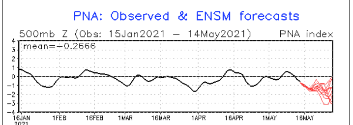
Yeah...it seems the models are trying to get us into a more important early warm anomaly ...and maybe we're just seeing a reluctant sort of emergence in doing so ? I've bee warning Kevin all morning about our sore-butt spring climate but it seems every time I do, the models deliberately go even more against - fascinating really... The telecon's are falling in correlative significance, (seasonally..) but ...fwiw the PNA is getting into historically deep territory in the CPC mean ... Don Sutherland had posted recently that it was some - 2.47 I believe ... At the time, this image below was not depicting what this image below is showing now - lol... The mean of those mop-ended members ... ~ -2 there, with a few members even deeper as we can see clearly ... It may just overwhelm the hemisphere regardless of any lingering blocking signals/tendencies.. It seems the models have been tussling between that happening and some backward -NAO exertion/driving troughing through the Maritimes but ...if this signal below gets more momentous it probably doesn't matter ...the progressive wave signature will transmit through the domain and send the western limb of the NAO domain space packing -
-
Outside my front door, ...which is gaping to gulp in the 76 F balm as much as a possible..., there is a metallic awning. These small dark CU actually ping the top of that awing as the pass over with small rain drops - like 10 drops per cu and that's it. Weird... Fair weather CU spritz. But, looking around, there are also glaciated nebulae encasing some of these CU edges so ...it's kind of hybrid between both worlds. Like it's snowing at 6,000 feet easily ... and very unstable but only in like 100 mb of total depth ... not much getting to the 500 mb level even.. Just bouncing densely around in that layer under a cap ... It's like a snow shower atmosphere sitting overtop a 75 F lower elevations..
-
Yup ...this GFS run continues to trend away from climatology on that ridge - and by that I mean, literally ...it is UNclimatologically sound to expect that circulation structure to win out that way - but ... be that as it must, if the present solution works out, we somehow dodge the N/door and/or BD boundary(s) through that period and spill OV/ G. Lakes early heat dome into the region. Assuming so ... this doesn't have any tracing back to a Sonoran or SW air layer ejection modeling so... the heat is sort of 'home grown' .. deeper tropospheric heights working with high hot sun of late spring will amass 82-88 time temperature departures inside that synoptic region. But keep in mind that we are still talking about D5 ... 7 with active polar jet streaking by N of Maine so it's precarious. I hope not ...I hate BDs with the passion more intense than the foresaid sun, but.. gotta be a realist too
-
Let us know how you feel over the course of the next day or 2 ? I'm getting my 2nd dose ... two weeks - I'm hearing wildly varying reports on side-effects ranging from nothing to an ER stint - no rhyme or reason or pattern discernible either. It's been yes and no for maybe cases in every direction. Zero pattern. I guess scatter plot or not...the average is at least a semblance of reaction above zero - so... I'm just trying to get a fix on expectation - ha, not that your experience should tip the registry here... I didn't get any notice/report from the first dose, personally -
-
isn't that 'Cousin Eddy' 's from 1989 Xmas Vacation - lol
-
Lol... I prefer to think of this phenomenon as the weather happening at you ...not around you - I once had to be in a meeting with hook echo on radar 4 miles away while hail core was signaling golf balls, and there were no window in that conference room. man... never forget that. All I could do was wonder if that was thunder through ten different walls of an office building's diffused auditory vagueness. after the meeting there's leaves and small branch debris literally grounds with scung lines from the curb flooding so deep it came across yards of the complex. Sun was shining...
-
Yeah... I mean, one does not have to be a codified Epidemiologist to connect the dots on this -
-
Heh.... how 'bout, ' we're all dead in 50 years by life expectancy alone ... excluding the proverbial lightning strikes of chance so, f.u. - I'm outta here' You know ..it pays to find a congenial work environment with non-douchian managerial apparatus of at least modest humanists in charge ... I can walk into my boss' office and say, " Hey Jim - uh... - " interrupts, "see ya tomorrow" The amazing thing about that is ...if the employee in that circumstance and scenario does it with relatively infrequence, it's not even remembered. And, because they are happier, the are 10 X's more productive
-
Well... we'd have to physically calculate the difference between radiative budget, versus mechanical cooling source - that latter skews the cooling amount. See, in that case of 'lower els' ... that's drainage and accumulation, due to basin phenomenon ..blah blah ... But what we were talking about is strictly the black-body thermal storing/environmental caching as possible reason for lower DP warm nocturnal nights, during residual pattern ( i.e., unchanging in the latter sense ) .
-
Which I'm okay with ...by the way...
-
you know it's funny ... I check the "Worldometer" daily COVID cases ... if for morbid, just to see if there's any hope... () Yeah, the case loads are painfully slowly dropping as a longer termed trend. It's sort of 2 steps down, 1 step back up...3 steps down, 4 steps back up, 2 steps down two days in a row, 1 step back , 2 step down, 1 step back... But in the scalar daily numbers, we are this week showing more daily cases than we were BEFORE masks became a millionaire over night cottage industry. Yet, from meme to the IMC ( Industrial Media Complex) and in between there's now this wanton fervency for ridding of mask - 'just can't wait any longer' ? We were not born with masks. 750,000 years of Human biological immune system evolution never needed them, otherwise, ... As much as we conceit we are not apart of those natural signals ( called bow-wow instincts - yeah, ...we're all just sophisticated f'n dogs man), we are showing the instinct to 'get it off!' Put a mask on a house cat and watch what it does ? ...What we are doing now is just the sophisticated frantic swipe and churling mews ... it just happens to be spread out over a mere performance that makes us perpetuate our belief in control over our domain. Because in pure numbers, ...if it was enough to trigger the mask frenzy at the front side, we should be removing masks in 2034 - LOL. Kidding of course... I mean, yeah - we know more about the transmission of this thing and have more empirical -based awareness of what it does at the individual level... integrating to the whole, that tends to assuage policies given time. sure.. But, you can't tell me this isn't hypocrisy to "get if off - I don't care what the cost," to some degree.
-
Yeah cuz I was just thinking about this further. A 'radiation budget' and the physicality of an environmental setting, 'might' play a role ... I mused up there about the 96/31, typical lower Saharan diurnal spread of desert air, as being inconsistent with that idea but hold on for a second: It occurs to me, ...that's not really a very proficient black body example. The desert is white and pale sand and dust. These surfaces heat up, but also do not store as much radiative heat - such that at night, they don't have as much radiation to give back to the kinetic temperature of the atmosphere - so the cooling momentum is larger and out 'weights' in that sense, the restorative availability - temp plummets. Interesting... I think there may be something to that. Contrasting, ...if we are in absence of CAA in an otherwise dry air mass over American soils and physical settings, we are far more proficiently storing radiative energy from insolation during preceding afternoons - and thus have much more in in the nocturnal cycle to radiate back. I don't know - it's as good a hypothesis as any. If the dark body objects.. foliage and so forth, all store more thermal energy during the day, a clear night has to radiate more. Such that after a couple ... few days, the ground is gaining more and more energy than can be completely emitted away ..so there is a net thermal gain after repetitive days of it. That "might" offer an explanation for the "kinetically charged" dry air phenomenon we are scratching heads over - ... why after a few days, the same DP stays warmer suddenly. It could just be black-body storage phenomenon
-
Mmmm yeeeeah I'd not take that to the bank - no way. ... I mean, we grew up in New England's "Pulp Fiction" basement scene, spring horror ... Sorry, that above cannot be bankable. I was looking things over with a smirk and thinking, yeah ...it's warm days on the Euro but anytime we see a +1 SD velocity northwest mid level flow/jet stream hosing SE from mid latitude Ontario to over the lower Maritimes, that's usually an automatic BD genesis at some point or the other. I mean, the model tries to maintain that structure as a 'laminar' flow with no perturbations or 'bumps' in the stream, for days? A this range ... good luck! Granted, that is just the 00z run ... We could be on the cusp of a series of runs that show less vestigial -NAO ( which is what that is, btw - a tussle between the -PNA trying to overwhelm the circuitry across the country, while the NAO imposes some sort of subtle blocking that's less than more obvious at the same time... ). I mean in fairness they intimated as much, "..if current trends hold" so we'll see. It's almost like to separate probability curves though.. lol. Like, all that modeling is one, ..then, the other probably of just being b- f*ed... Those seem to be driven along by different physical processes. hahahaha
-
Yup ... particularly in these pattern "seam" nights like this ? Basically... in three nights, it can be clear all it wants, even still maintaining a rather low DP ...RH ... and the temp stalls at a 47 everywhere. Yesterday, whimsy with words I denoted this as "kinetically charged nocturnal lows" .... trying to sort of 'cartoon' describe it when it seems you can keep lows from falling sometimes, without the obvious DP assist. It just seems like there is something more to nocturnal lows than just DP ... It's like sometimes - not sure why or if this is even real ...anecdotal - a DP of 39 under the same observable synoptic metrics stalls everyone higher ...but those same calm winds and clear ceilings and DPs like last night, over-achieve by several... I've hypothesized that the atmosphere not including WV ...also has some vestigial thermal cache if perhaps several days of processing. But than that doesn't make sense at all when we consider that deserts routinely go from sub freezing to very hot in afternoons. So yeah... I guess I don't have a f'n clue on this one LOL
-
In fact re the country-side flora ... the sugar maple - type species are noticeably fuller in the leaf bloom just since yesterday. It's like we went from 1/3 unfurl to 1/2 or even 2/3rds in the one night. I wonder about the temperature sensitivity relationship in vegetation ...if single preceding day's/weather patterns can trigger a specific night of robust recovery. Interesting. I mean it could just be coincidence, but yesterday really 'felt' more like shorts weather ( thought I kept with two layers and pants like a middle aged noog lol ..) anyway, and the leaves were tinier. I remember thinking about this, too - then this morning they clearly and discernably seem more open/bigger ...casting more like real shadows on the ground.
-
Got chillier last night than I thought it would. Bradley CT, Nashua NH and Bedford MA all pinged 39 - decoupling's a 'cast killer. But, it's also warmer by hour this morning's recovery than I imagined, too - 69 already here as of 9:15 am with a few 70 even ... home stations dappled about. Fithchburg MA is 66 at 9: am, and Boston knocks the door of 70 too if not already there. 76 incoming ... The sounding exposes this as a weird scenario, actually. I mean 500 mb thicknesses are still chilly, mid 540s... You don't typically see temperatures bathing the surface in mid or even upper 70s along with/under that metrical condition - more like a triple nickels dm thickness for that range. It's like the warmth is stacked in the bottom of the atmosphere ... It's making the conditions unstable. LI's reflect that being down to 0 to +2 range .... Low DPs are probably making parcels invisible - lol... Like invisible CB.. kidding. But, we might still observer some crispy pop-cornies ... The very superb heating conditions with no cloud, and purer air in absence of any offsetting CAA anywhere is probably going to cap temp early, and then bounce around on the thermometer, this steals 10ths of a degree as it erodes it's way up to 77 in few spots maybe. Basically ...anatomy of utopia
-
Thing is I like motorcycles in general concept. I just don’t like that they are used as ego boosters ... I don’t like how those in ‘the look’ are supposed to personify this non conformed care free image ... yet they care enough to go out of their way to affect an image - you’re a hypocritical full-of-yourself asshole trying to force people to give you attention. Nothing else. I can’t trust other drivers, either. And I have to admit every time I am immediately behind a motorcyclist some part of my internal monologue, says “oh f* now I got to deal with this guy”. It shouldn’t be any different than any other vehicle but I’m sorry it just is when you see that person exposed like that… I don’t know I just don’t want to give people yet additional reason to have internal monologue about me
-
What is meant by tested positive in India when in context of having been vaccinated tho positive means nothing ... vaccinated people will be asymptomatic carries. Vaccines don’t stop particles from going up ur nose.
-
yeah...I mean what - are we supposed to do again, wear dog tags with immunization crimped into them now? Waltz into a place ... "yo vaccinated" and that's it ? Prediction - all out brawls. Some will waltz in, 'hey, are you vaccina -" cut off, " F you !!
-
Definitely something dodgy is ... wth
-
Yeah ... feed the complacency. 'Well if we can lower guard - ' ...that's how the 51% population thinks in my cynical world lol
-
wait, I thought the CDC just announced no masks outside - what?
-
Yeah...that's the one ... it was 2010, not 2012 ..
-
I go through that solar angst at the other end, too, but opposite direction... It's why I prefer my ensuing seasons "front loaded" ? Like, I'd rather pop winter a week after Halloween and have it be snowy through the end of January... Claim a positive seasonal snow result by Jan 30 ...and I don't really care what it does in February. That's sounds absurd, I know - considering our climate and the beefiest bad-ass-iest bombs of lore and yore have always happened pretty much after Feb 2nd ... (unless it's Dec '92) so, yeah, in fairness, I'll rejoin if it's worthy. Otherwise, ...the sun f's up even Feb too. The closest I experienced this was in fact ...fairly I'd say above the 90% achievement, 1995... We mix- jobbed a 3-5er matte down and froze it solid around Nov 9 up there in the Merrimack Valley at school, and didn't see bare ground until the big thaw at the end of Jan... Nickle and dime snow events with steadily more ridiculous cold. I remember hip to shoulder high snow banks down the street from WHDH in downtown Boston, in 9 F cold, with the snow squealing under sidewalk footfalls ..it was around the 15th of December. That's how you run a front loaded winter. I mean if it's still 60 F shorts weather at T.G....I'm like great, days get longer in a month and we're still not killing the tomatoes? I almost think it is easier for our area to do front loaded winters than front loaded summers. I remember 1995 and a handful of contender winters ...2008 ..2010 maybe ..but only one summer, 2012.. It was ludicrously warm in March and that sort of just kept up... we had 96 day, May 20something with a meso over town at night.
-
69 .. 70 at most home sites... I still suggest if the sun keeps up with reclamation of the firmament .. we may pop a shockingly important 74


