

Typhoon Tip
-
Posts
43,298 -
Joined
-
Last visited
Content Type
Profiles
Blogs
Forums
American Weather
Media Demo
Store
Gallery
Everything posted by Typhoon Tip
-
Definitely think the sensitivity (also) here is related to the orientation of the N/ stream SPV pearling going on N of the Lakes to the western/lower Maritime. Ubiquitous ...even subtle backing off on the suppressive nature in how that is integrating everywhere ( really ..) ... immediately evinces the incredible baroclinic potency - it's like under constant pressure, and as that backs off.. metaphor slowly unscrewing a cap and we hiss our way into a flat wave NJ Model low type in step.. The ICON - obviously you know all this gunk ... - was back well off that SPV aspect a few cycles ago and had a pretty impressive short duration albeit major impact, and another 3 degs of lat/lon relaxation may bring those robuster solutions back to the discussion, another 6 and we open wave-style fast moving bomb. It's really a blessed time for multi subforum interests ... to be relayed into another focus in such short order to the last.
-
I'm sure other's have noted this ... but just in case - The 72/78 hour GEFs have all the spread on the NW side of the consensus cyclone track - which as 101 deterministics go ..that's typically where we'd see future model runs correct toward. Noting at 84 hours, the spread persists, with some deep members there, too - few of which are < 980... In fact, all the more depthy members are in that NW skew plot, which seems to suggest there is some track sensitivity based upon the intensity - Euro/EPS outta be a hoot -
-
To Will's point earlier in the day (other thread...), the NAM as an 'isolated sweetener' really cannot be trusted, but trend establishing over the bevy of guidance sources lends credence. ( Obviously we don't need "reminding" that trend is not the end...so this is an evolving scenario still - just sayn' just sayn' ) The ICON - in fairness - had major short duration impact by this system over a couple runs recently ... back when it was centered more on the 8th. Also, prior to that, the Euro as we know was having an raging skizoid break with it - ...it's probable that it's governing mechanics in the general eddy were always there but the model tech at this state of the art is still lacking when there's this kind of velocity saturation/compression maelstrom characteristic messing with coherency. So we get closer in time... his system's governing mechanics appears to have been moved up in time, ...more 7th proper. That in of itself is actually a nod in favor of this thing being a real mechanics presence in the flow, because the flow is fast and the correction would tend to be to move things up - spacial-temporal placement during fast progressive flow constructs still corrects sooner.. etc. Probably, this gets earlier yet right down to now-casting ...and ends earlier too...
-
Ah .. ran for an errand - glad someone did ! ...talked about firing one up two days ago, but really ...the models and even individual members were buck-shot and usually lacking a coherent consensus, while also not having indicators/Tele support .. are all red-flags. It seems fitting that as this comes back there's bit more coherency surrounding the 7th - it lends to formulation of consensus
-
Can I use this for a thread ?
-
This particular trend movie is exquisitely useful for this specific scenario - LOL Seriously though ..it wonderfully exemplifies the high degree of sensitivity in the correct mass-field handling of the totally integrated field. The compression locks the whole thing from JB to Florida...where if the N/ stream SPV N moves even a little bit, en masse the flow geometry all he way to Florida adjusts in concert - the wave ends up more NE trajectory instead of E and that enhances cyclogen response... and blah blah - But, notice the N / stream is slightly less suppressing across this sequence of frames. Nice contribution !
-
Yup ..I just found the evidence for that ... This is looking like the old bate-in-switch two-step routine in the guidance. You know... mid range drops it .. focuses on the wrong thing for couple few cycles ( like the 00z Euro? - which I'm still a little confused about that one ). Only to have the 8th return -
-
Well ...it was originally the 8th ... I'm not sure we are really tracking the same feature frankly - I admitted that in a few morning snark intoned posts - ... I'm trying to wend this 7th system back in time vs modeling ...and I'm not sure it is even the same thing. I don't presently think it is? It is possible it has just been moved up 24 hours in time, owing to a very fast flow - it's part of the uncertainty manifold of this sort of compression shit ( god I fuggin hate it too - ) Anyway, I think if the Euro bangs the NW trend drum at 12z, that is pragmatically entering the Euro's very high verification scoring window ( being < 4.5 days out...etc) - sure.. I suspect the trend - if I'm gathering this right - started on the 06z FOR THE 7TH ... ? lol I just think in honesty, if I had started a thread two days ago for the 8th.... I wouldn't be sure this wasn't a separate manifestation out of the ether of an inherently "uncertainty-rich" pattern
-
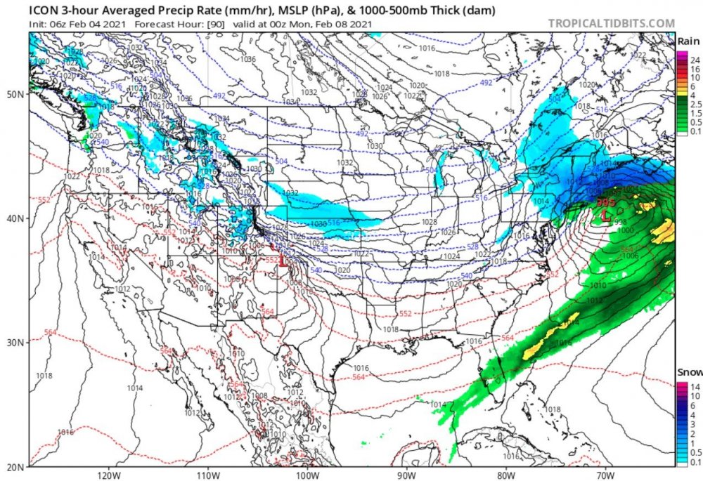
Truth is ... no model should ultimately be totally ignored - I'm just bustin' ballz I know there's 'need' for lack of better word to engage in the modeling ...almost like going to an art show, when and where those that engage in fantastic works of art ... get an emotional response there too. It's sought - I get it... But in the practical sense, as I have said in the past .. these models do not arrive at a given solution that "can't" happen? Perhaps less than likely, and their physics may be missing something that makes them prone to solutions that just don't go on to verify ( ha! Like, the prescient line of sight into the intentions of God ).. But, their solutions are not IMpossible. How's that for bargaining - ignore the oppressive reality of very low probability in lieu of rationalism - nice That said, here's my crazy "unlikely" contribution to the morning's gallery .. . the 06z ICON painting of 6-10" of flat wave silk !
-
No .. you guys are bargaining to make the NAM right - difference ... but okay, Scott brilliantly evasive tactic using humor is understood.
-
just trying to make sure people are paying attention LOL
-
Okay ... did anyone mention that the 06z ICON actually had a low end warning snow for everyone save James ( supplying justice to the cosmos even ...) ? For the 7th
-
You guys are spending waaaaay too much time philosophizing the NAM lol So it's not even the 8th ... it's the 7th now... okay - was the 7th on the 06z Euro then?? Let's get this "bent" more than it is already: the last two days, we've focused on the 7th, the 8th, 9th and 10th ... while I - of course - bloviated to an empty room over the 11th through the 15th, all over a-b-c-d-?E? events happening in x-y-z/ 2.5 day-span time intervals... Jesus, we don't need a Sven diagram for this cluster f, we need a new General Theory of Relativity
-
I assume we mean Sunday evening in coverage here - I was thinking when I looked at the last three cycle -trend of the NAM, that this smacks pretty painfully as the typical NAM-o-rama-ding-dong circus clown act of popping the low deeper and ominously NW like frames in a movie, clicked along in three or four short cycles. You know...go to bed, wake enabled. Lol. I mused internally, '..This may even do this one more run and get even more impressive, before boom boom boom three cycle trend goes half way back to the original nothing...' And what we end up with is a flat wave of 1/3 potency overall, tickling LI/S RI and the Cape with light snow... towing along an angry bevy of blue-balled storm neurotics It's not a declarative forecast lol... I just have the experience - ... the NAM between 48 and 60 hours back in the day, almost always had a NW position bias... Now, granted...we are out there in the 72 hour frame, but... I'm not sure if the former has ever been addressed when they increased it's range to 84 hours 10 .. 15 years ago whenever that happened. I may have a bias against it for those early years - sure... Will's right - the NAM is not alone though... I am not dim or stubborn to that notion. So I guess ... grudgingly, we have table the notion -
-
I wish we could adapt a rule/policy that all references to specific events must include a date said event in question is referring ... If the post does not contain a date it's content is intending to hone .. it gets torn up shredded in an anime where the posts material is destroyed right before the poster's eyes.
-
-- Two vaguely coherent systems out there actually .. The 8th, now on life-support, and as of 00z the Euro introduces the 9th more aggressively than prior runs - and apparently something's up with the 06z Euro? Not sure which feature is in discussion regarding the 06z Euro. Scott's right - whatever happens of either of these two systems they are in and out with rapidity. The compression/speed saturation doesn't lend the other way. Could be sprayed by several 1-3 or 3-5" ers over the next 10 days. I wouldn't even be shocked if the 8th came back, and 9th pancakes S again... Fast flow with high sensitivity for latitude placement based on utterly invisibly subtle physical exertions, means that positioning these 'events' in space and time will require shorter lead to gather confidence in what happens and where. -- I mentioned later in the evening last night about the 11-15th event period of interest.. As is typical at this sort of deep range, whatever is triggered in that range, in models, is wobbling spatial-temporally .. ranging to other models not having anything. I have seen it back closer to the 12th, 13th ...18z GFS had a juggernaut centered on the 14th... 00z, bombs eastern NE with a ferocious cyclone through the Harbor. These are variations that - to me - appear tapping into the emerging general numerical instability ..not necessary honing ( duh ) anything necessarily real. But there may be tremendous baroclinic gradient between 35 and 45 N .. left in the wake of next week's -EPO cold soak/compression flow.. Rather classical, regime change then offers correction event potential. Last three night's tele progs at CPC indicate the -NAO renewal ..and most op. and their ens means flag west limb variant ... whilst the PNA tandem rises in the GEFs mean to ~ +1 SD... telecon convergence ... But first we deal with these smaller synoptic perturbation ... and keep dreams alive that one over-produces. I don't think the ceiling is too high in this regime-like pattern incoming because aforementioned compression not allowing for differential processes to unfurl ... but, who knows - the ICON solutions from the other day, while obviously unlikely, didn't formulate in a physical vacuum of forcing in that guidance so it shows that nothing's impossible. Or like this 12z NAM run ..heh.. but, the NAM's patented NW bias beyond 48 hours of 10 years ago ...I don't know if that tendency has somehow been corrected and that smacks as that. It's like this in this maddening type of flow construct - yin and yang pro and con head game.
-
In the meantime that is a lot of compressed waves struggling to hold onto identity but may still have enough to swath occasional synoptic moderate wintry bursts. 2 day periodicity
-
Yeah that’s the 11-15th event .. its been wobbling spatial-temporally back to the 12th and 13th ... this version is more 14, but the entire period is in teleconnector convergence with dropping NAO ( impetus being not already dropped ), tandem +1 PNA arrival. Cold load is completed and in place while gradient aspect associated (flow compression ) relaxes; meanwhile said tele field disparate sourcing transmits and results super-synoptic/synergistically promoted deeper negative geopotential anomaly ... again ( and it’s early ) another 90W-60W by 35N-50N inside of a month ... both -NAO over the western limb of the domain I believe is useful/referable. It’ll come and go ...but suspect this has another hemispheric footing in that period of time
-
It's time sensitive a bit ...but these graphics indicate an interesting phenomenon - TD designation over land, and a long duration survived track .... over land tropic.ssec.wisc.edu/real-time/storm.php?&basin=austwest&sname=18S&invest=NO&zoom=4&img=1&vars=11111000000000000000&loop=0 This thing is tiny, too... We've seen anvil explosions in April 'Plains thunderstorm outbreaks dwarf that little guy. If someone were sitting out in their lawn chair, ... 70 or so miles away, it's not likely this thing would even fill the horizon. It's things like this that challenges the definitions we put on atmospheric events that tuck them neatly into categorized phenomenon. It's like a lamphoon - =maybe. Thing is, I've seen that around the NW coastal region of Australia before ... there are over land Invests and TDs.. Something about that region's climo -
-
Lol, but we've been doing that all morning and mid day... pages of it -
-
I do now fo' sho' ... I lost a lot of weight. I'm a fairly tall guy at 6'2" ...so toting around 230 physique before, it wasn't like I had some unsightly front-butt or anything. Taller people spread it around yuck .. Anyway, now I weigh like 180 -or as of last check. Maybe 185 mid winter lbs. By choice ... lifestyle adaptions. And I don't really eat much sugary shit like ever.. Not shy about vegetables and Nature's natural candies ...like melon, berries and mango fruit. It's amazing, that kind of sugar makes you lose weight - fascinating. Once you get used to eating that, it can almost be too much. Telling you ..industrialization of foods has seriously f-ed the human palate into a captive provisional psychology. I work out every day ... except about once per two weeks on average. Oh, I'll get invited to some distancing- protocols violation .. Or, finally it just catches up and I need the rest..I did that two days ago. I notice it's time when I feel like I'm breaking speed records on the stationary bike, ...come to find I'm five minutes slower - D'oh. I can do this because I sequence between Elliptical, Peloton, and 10 K runs ... start over rince repeat...Such that there's 4 days between the next time I do them - Those are different muscles I guess... it works for me. Anyway, where I'm going is that I get cold ? ...I do... I have to have my house at 72 now or my hands get cold. I have noticed since losing weight that a situation like that is more and more so a welcoming sensation. If it were like 48 F late March day and I wanna run to the store, my car is so cozy. Lol
-
It's interesting to me that we ( at least I ... ) have not seen a cross-polar Siberian express -type conveyor orient its self through this PV weakening saga this mid winter. It's been like that above.. the flow sort of migrant around lily-pad blocks and ridge bombs - ...sort of ending up with weird hemisphere that's difficult to really ascertain the R-wave counts...but there are those nodal cold wells in the rampart around like we see above. It's not a 'kidney bean' look where you have a nice arced NE Pac hemispheric footed ridge that -EPO pulses and the flow transports. Meh...there's enough cold and that's a stormy look. Just an odd observation
-
Mmm ... I don't ever 'worry' about the sun angle - I've seen blowing snow cob-web off of flat roof eaves on April 10th at 1pm in the afternoon. Sun angle at our latitude may be over-assessed as a limitation. It's influence on modulating the environment is obvious; foliage triggering, and when the atmosphere supports a warm afternoon, it will supply the energy to get there. The hemisphere warms that way .. and thus, supplies of cold become ever premium. But, a cold, fresh supply of polar air under the density of a crying CCB head, wins as late as that time of year. Shoot, just last year we witnessed virga exploded CU with snow flurries surviving the fall to the ground, while May sun was undercutting the falling shafts ... The solar stuff I've brought up in the past, that's in deference to the nadir ending and is another discussion aspect altogether. It's just like everything; folks want to have nice neat tidy boundaries that categorize aspects of nature into obeying groups of behavior but ... the lines are blurred. All it means is that it gets harder and harder to snow as the spring ages away from winter... and then in July you get 10 days when it's like 99.999999% chance of not happening ... at which point the percentages start dropping ... until January, when there is a 99.999999% chance of bi-polar flights of euphoria followed by neurotic inconsolability
-
Still suggest the 11th - 15th is the next bigger ticket item... If the 8th comes back against the odds of that synoptic evolution ... so be it. But there is another converged teleconnector era ... PNA rises positive during a polar index relaxation leading to the Ides
-
I think of February as the first creak in the door as the ghost of seasonal change. Meanwhile, protracted talcum powder bombs may be choking civility LOL but it's still out there. The solar turns around and like I said, we're just talking a creaking here - don't get one's panties in a bunch. August is the antithesis ... if you take all August ( February's ) in history, and compared them to the rest of those years ... the ballast will demonstrate that the corner actually turns in those months, probably well prior to anyone taking sensible notice. Anyway, not sure what the EPS is doing ( maybe Will's weeklies would be interesting but my snark impression is those are pretty N/S -like beyond D. . maybe 11 or so... ). The GEFs show lingering neggie AO though. IF IF IF this -AO is driven along by the SSW stuff ... that can plague springs with unusable -NAO pulsing. Spring BDs cold mist seem to occur at least excuse. However, this SSW --> -AO occurred earlier than spring killers of past though. When that happens in mid or late February, the ensuing spring doesn't exist... You get that gamma-winter that flips to a heat wave in the first 10 days of June; after which a cooler, dryer than normal summer with a whopper anomaly in boredom characterizes the west of the way. But in early Jan like this one... it may gestate over-with and render the spring back to a La Nina controls. Which is ...what? I "think" it's mild/warm in the OV/MA? HC is always there, too. La Nina is would tend to constructively interfere with that ... unclear what that emergence would entail but it doesn't sound on the surface like we're heading for a wintry March. Maybe this should be entry post for "2021 Spring and seasonal change monitoring"


