

Typhoon Tip
-
Posts
44,215 -
Joined
-
Last visited
Content Type
Profiles
Blogs
Forums
American Weather
Media Demo
Store
Gallery
Everything posted by Typhoon Tip
-
Occasional Thoughts on Climate Change
Typhoon Tip replied to donsutherland1's topic in Climate Change
https://phys.org/news/2021-08-climate-scientist-bad.html Peter Huybers Bio and perhaps citations, may be found here: https://eps.harvard.edu/people/peter-huybers He has a nice way of outlining the perils of CC in terms and metaphor that is probably more tenable to the average populate. Unlike me LOL ... Anyway, I particularly like the this paragraph: "....Studies indicate that the melting of the Greenland ice sheet is irreversible in the sense that, after the ice sheet melts, it would not regrow even if we otherwise returned the climate to pre-industrial conditions. The ice sheet is a vestige of a colder climate deeper in Earth's past that is maintained, crucially, by high rates of accumulation on its flanks and cold temperatures atop that its own height affords. In this sense, the melting of Greenland and the consequent rising of sea level are irreversible...." I suspect this is true the vaster array of Global environmental systems, where they are only deceptively linearly related to global warming. In other words, cool it back down, they can't return to normal because it is not just a matter of that one factor. Whether the interview/re-draft of it intend to or not, one such region is that western end of Antarctica - if that one succumbs ... uh, riiight - What makes this particularly scary - to me - is that those hereditary base-lines may be required for maintenance of most species living. This connects the dots, quite plausibly, with the Biological science aversion, that we are in fact entering/entered a mass-extinction event, already. For example, take this turn of phrase from the same article: ".. in describing melting of permafrost as well as the warming, acidification, and deoxygenation of the ocean..." I personally began warning of this years ago, that if we tip the oceanic chemistry to a point where there is a phyto-plankton ecological collapse, that is roughly 33% of oxygen fixing for the atmosphere above the oceans. Larger organisms require oxygen? The reason dragon flies were the size of kites during the Jurassic, was because the oxygen they absorbed through their skin was enough to do so. That's not a path a species that breaths air really wants to go down ... Time and science is consummately revealing that these systems are more complex than previous generations of study understood. Part of that complexity is that they are also often intertwined, quasi if not totally codependent. Therefore, as one is teetering with finger tips to hold on while the heredity of past climate and chemistries are eroding, when they let go ... the notion of the cascade collapse becomes academic. These geological eras move at invisibly slow paces, unrelentingly, beneath the qualia of the common observer. Even though we are seeing changes now, the momentum was gathering decades ago when there was really no way to see the change. I have opined about this at length in the distant past - the problem that exist in climate change vs public awareness/urgency, is that it could not be physically registered during the earlier phases of the predictions. It had no corporeal-based advocate. You don't feel, see, smell, taste or touch it ... Human beings need these tactile "proofs" in the everyday assessment of reality - it's true in all biology. We have higher order intelligence, but it's at conflict with these senses, whenever the abstraction of esoteric math isn't seen. One irony of our evolution is that we both can predict by powers of that higher intellect, but don't believe it ... Until time runs out, and that psychology only gets it when we are 'seeing the light' -
August Disco 2021. Do record dews continue?
Typhoon Tip replied to Damage In Tolland's topic in New England
Yet this summer's left some points on the field - perhaps to Kevin's chagrin. I keep seeing this ... a kind of quasi - Kalvin Hemholtz. The band of the seasonal continental conveyor is pushed N of normal and it's curling around and pooling/ ...tendency therein, of 850 mb cooler air in the OV I've been seeing this with increasing frequency in the past 5 to 7 summers, but this year it has been more common than any priors. We are not in the heat this year despite those June numbers ( I mean that euphemistically - it could have been worse and in some sense perhaps should have been but the circulation plague above is folding over and islanding off D.C. to protect policy makers from first hand GW experience ...LOL). In fact, that June heat was almost entirely solar drive ( being under the perennial apex ), with huge bloated if not historic geopotential heights offering nearly unlimited hydrostatic diurnal expansion. So we made the mid 90s with 594+ hgts? I know it sounds like a sacrilege to describe the hottest June on record that way, but .... that I argue was more based upon elevated DPs and night time mins, and pattern persistence, more so than cresting high temps in the VIP party. We've made mid 90s heat waves out of 582 dam in the past. I noticed this back in June ... we never really got a real Sonoran/western heat injection into this thing.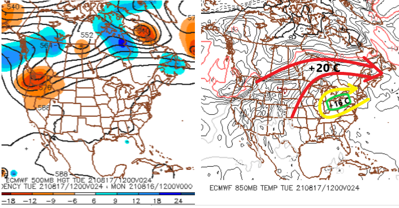
-
"stop the covid talk" ? ha, what happened while I was gone - I mean, I'm not complainin' or nothin' ... 'bout time really. But for morbid -
-
August Disco 2021. Do record dews continue?
Typhoon Tip replied to Damage In Tolland's topic in New England
-
August Disco 2021. Do record dews continue?
Typhoon Tip replied to Damage In Tolland's topic in New England
yup... (bold) Firstly, I am also being hyperbolic in jest to a goodly dosing in that - haha. I'm about as cynical these days with the weather as I am with sociological impacts of the 7.5 billion assholes effectively influencing that force; but don't ask me to describe how I really feel. Anyway, in more rational prose ... eh hm, the ENSO may still be useful. But how much? I suspect ( strongly ) that its ability to influence is being muted. I wholeheartedly agree that it is too much in a lot of this stuff/practice. The problem is just like I have said so often in the past but have since given up: The Hadley Cell is expanded and continues to do so ( primer of newbs: 5.2: Modes of Variability: Past and Projected Changes; 5.2.1 Width of the Tropics and Global Circulation; https://science2017.globalchange.gov/chapter/5/ ). That expansion is not my idea. It is empirically observed and scienced everywhere except apparently in the readers of this forum, who btw seem more interested in playing fantasies of yore, as though climate's heredity is immovable and would rather make jokes about the former. F.u. d-heads... Go vote Trump while your at it. But it has moved N and its envelope engulfs the latitudes of the previous climate ... before the hockey-sticking of jolt warming began in earnest around the time of that 'ceremonial beginning-of-the-end super NINO' of 1998 ( maybe James was onto something ). This has happened while the polar domains still have enough lower geopotential heights that ... blah blah, flights from Japan to Frisco, or LGA to Hethro seem like a free ride. The HC is subsuming and engulfing those. In fact, the HC is probably culpable in the enhanced easterly jet at lower latitudes that is also observed. I am willing to posit that the new base-state is a modest La Nina when comparing/using previous climate -base as mode determination. ...interesting. In that sense, this La Nina stuff we are measuring is actually more the new neutral. ... It's interesting... there are Global systemic changes that are exceeding the single human life-time, and even within life-time events where/whence science has a chance to go through the scientific rigor. By the time the observations made, the data is gathered, and the mechanics "precipitate" ( always intend to annoy with puns ... ) out, the system has moved on to another state. Or, it is causing some events to take place that redirect attention...etc... It's basically as though we are in a slow-moving climate bomb that has detonated already. But my point and hypothesis is/was going to be, when the HC began to expand beyond where the MJO and the ENSO and the MEI used to interface/gradient against the westerlies, that changes the physics in how those fields can force the wave mechanics. If one cannot get their heads around that, they should just watch the weather channel instead. Then, yeah...I suppose increasing conflagration at global scales .. uh, fires... solar cycles in the 'super min' ... jesus. We are supposed to be a Arctic, multi-decade oscillation that favors lowering modes. But that becomes skewed and screwed up because the speeding hemisphere causes the AO to rise because it it is intrinsically/physically offsetting slower PV speeds and blocking. That's sort of a strong duh-hint to why we see the blocking waiting to March/April - maybe. ... -
August Disco 2021. Do record dews continue?
Typhoon Tip replied to Damage In Tolland's topic in New England
Ah yes ... post August 15. The perennial onset of this species of Global Forecast System's proclivity to rush seasonal change can already be seen, if not so much empirically, by attitude in the way it is handling the polar jet and the features above the latitude of that fluid demarcation between the HC and Ferrel latitudes. That being, too deep with cold layout and individual cyclone mid and U/A nodes that are rotating through the medium to be more precise. But, the irony is there is a tendency for enhancing gradient in transition seasons, during this leg of the climate change curve, due to the polar regions having still substantively lower geopotential mass-field compared to the encroaching HC; that encroachment causes the sloped troposphere ... triggering high velocity and earlier than normal climate R-wave structures result. That's all language to describe that while the latter aspect is causing seasonal variance to kick in sooner than mid last Century climate, the GFS probably coincidentally has an error that maps over top of it ( perhaps even hiding it's flaw from its designers - haha). As an aside: One of the counter-intuitive gems about global warming is that N/A then suffers cold loading earlier than normal, before the gradient really kicks in later on in mid winter season, which f's up all seasonal outlooks because no one is/has been paying attention this change. Here's a seasonal outlook that is probably all we will need, despite the dissertations, ...replete with chin scratching, temple rubbing, graphs and inference from land-sea telecon methods that are no longer valid because of CC: Weird oscillating cool to hot snaps with frost during the cold during Sept(Oct), with almost just as many 80s in Sept(Oct) ... By October, packing pellets and grauple showers when cold. So basically... 10 Indian summers between Sept 15 and November 1. Chances are enhanced some 30 to 40% above the climate derivatives from October 15 to Dec 1, for synoptic snow. And probably we see 70s in November a couple of times regardless of whether that happens. That's the autumn ball game... Basically, the typology of autumn variance on steroids. Winter, doesn't exist. Rather, some weird mangled version of winter that is too oft utterly disrupted, so not really clearly committed. Nope. What we get is snow storms and rain storms, in between +20 events in temperature. Lawns don't really turn that typical mid winter beige, and some commiserate-seeking poster insults that he/she actually saw a mosquito bobby around their forearm keying the car door somewhere out in the burbs in late January, despite that 10F cold snap that did manage to occur before the snow to rain disappointment near the 10th. Farmer's butt-sore Almanac. Big blizzard in February gravity wells Worcester to 12" while Bedford and Scott get 40" and manage seasonal normalcy. All this before it is 82F on February 17 thru the 23; instead of this alarming oddity occurring on just a single day .. three different seasons spanning the last five years, it will be the first time in history we put up +30 dailies for almost a f'n week... Then, dice roll until the concomitant end of spring due to the seasonal repulsion -NAO flex that always happens when the sonically speeding polar jet relaxes just a little and there's like some kind of thermal tidal back draft at hemispheric scales that causes us to retard green up until mid May. At which time is is 110 F in Spokane, and the Glen Canyon finally succumbs to the so-dubbed "Millennial Drought" and exposes its self, leaving the 710 foot arch dam a ghost remnant of some kind of influence ( hmm) - an omen of the future of the Earth, without human presence. The new method for seasonal outlook needs to be based up a hemisphere moving so fast that all other conventions become tertiary as forcing compared to that disruption. Done and done. -
August Disco 2021. Do record dews continue?
Typhoon Tip replied to Damage In Tolland's topic in New England
That's because you run in the middle of the night - duh... -
For those interested in the generality of the field and various phenomenon, Linda in the Pacific appears to have acquired a relatively rare annular structure.
-
Historic Pacific Northwest Heatwave of 2021
Typhoon Tip replied to donsutherland1's topic in Climate Change
I’ve been arguing since 1995 that heat and cold waves (temp extremes) deserve/need emphasis/inclusion in the fab five - Flood. Lightning. Tornadoes. Hurricane. Blizzard. ?Heat/cold? -
the impetus of snark is for the Bermuda thing... not the other way around
-
August Disco 2021. Do record dews continue?
Typhoon Tip replied to Damage In Tolland's topic in New England
ma-han ... jesus, looking at the operation Euro, sometimes I think the model is somehow, either by design or super-natural intervention, engineering ways to stop heat from realization around the policy makers of D.C. -
August Disco 2021. Do record dews continue?
Typhoon Tip replied to Damage In Tolland's topic in New England
yeah.. uh, big heat's happened as late as the 2nd week of September, but the return rate is rarefying quickly past August 15 - we slope. can we do it, yup! But, this next larger synopsis is a similar trait and behavior this summer, where non-hydrostatic heights balloon to ceiling extents in the models, but the hydrostatic ( 500mb 'thickness' ) seems to be sucking up the heat in order to get the DP up into the mid 70s/+anomaly. What has verified is what it is...but that's what the appearance of the modeling behavior has been to me. I tend to agree with Brian, based on that above propensity .. then adding in the climate slope, probably we do high night minimums, then drowning afternoons in theta-e weighting down the highs into the 80s. Might end up with the biggest 10 -day +anomalies of the summer, ha! j/k Notice the 500 mb non-hydro height anomalies over the TV while the 850 is modestly cool there ... it's a weird repeating theme - -
This is total bullshit... If "Fred" is a fuggin TS that thing NE of Bermuda's a category 2 hurricane, then -
-
Occasional Thoughts on Climate Change
Typhoon Tip replied to donsutherland1's topic in Climate Change
Great snark take! however, the issue is really much more a momentum problem? One that seems to always come back to that age old observation: Too much population. It's a threshold exceedance - Suppose 750 million is a hypothetical 10% of a total planetary population of industrial farters, that cannot diverge from the "save the planet" movement or else said planet will not survive. A total population that then swells to 8 billion, now that lower bounded percentage exceeds that 750. At that point, the lower percentage that continues to fart, represent a sufficiently large negative impact on the miasma that is choking the world. Not just for us by the way. As an aside, the Biologists attending the proverbial summit are waving their hands to be heard and no one is picking them for a chance to take the podium. It's like, 'Hello,' she knocks on the mike loudly as it triggers a high pitch whir over the speakers over head. She exclaims, 'WE ARE NUMERICALLY IN A MASS-EXTINCTION EVENT ALREADY..' One that may have begun around the time of the Industrial Revolution, but has insidiously gathered its own momentum while all these other aspects of this 'Anthropocene' epoch are being prioritized and analyzed and popularized ( although too slowly in the latter). But there's also another issue couched in there ... It's elementary to visualize, really. There is more difficulty in getting larger populations to motivate change compared to a smaller. That adds a T variable to an equation that cannot take a big values of T, or else that equation will = 0 ( uh...we need that hypothetical math to = 1 of course ) Like, take 100 people. If you need to motivate 50%.... how hard is it to fill a large conference room for an afternoon with a coffee break and complimentary donuts en route to getting them all on the same page ..etc. How hard would it be to do the same with 8 billion. duh. In other words, it not just a mass of toxicity arithmetic, but a piggy-backed is probably an unattainable sociological one because that lower percent drag-population has too much weight. I think it's too late. Not sure - or doubt really ... - whether that can be pulled back. -
August Disco 2021. Do record dews continue?
Typhoon Tip replied to Damage In Tolland's topic in New England
The heat appears over-top in circulation manifold next week.... We seem to have that kind of Kelvin-Hemmy thing going on again, where there is broad anticyclonic curl and the top loaf of circulation lobs over top - particularly seen in the 850 mb thermal layout is where this is forced/ best observed. Interesting.. I've seen this more frequently since the earlier 2000's, probably owing to faster polar jet zipping over southern Canada. This configuration seems to strand/pool the OV-NE regions in a disproportionately cooler 850 mb temperature region ...compared to what is typically seen in non-hydrostatic heights exceeding 588 dm. Not sure we get much higher than the mid to upper 80s despite those geopotential heights. Meanwhile, it's not helping the those same regions are in a modest surplus of rainfall... The hydrostatic heights have a way of holding temp counter-intuitively down once past the solar max/later August. Bottom line, ...lot of 87/74 type miasma -
August Disco 2021. Do record dews continue?
Typhoon Tip replied to Damage In Tolland's topic in New England
Yeah ? what part of Europe, Australia and the Pacific NW should lead anyone to believe that historic climate is a confident metric going forward - -
August Disco 2021. Do record dews continue?
Typhoon Tip replied to Damage In Tolland's topic in New England
We were 74-77’s in DP pretty common throughout the lower Lakes yesterday and continues to be the case approaching mid day. Synoptically this air mass is the source for back east. -
August Disco 2021. Do record dews continue?
Typhoon Tip replied to Damage In Tolland's topic in New England
NAM is doing the same thing it always does in heat .. it shirks Logan until the last minute. I think Logan gives LGA a run for the money on this heat tomorrow and the next day, even though it's buckin' for a 3 F lower max -
August Disco 2021. Do record dews continue?
Typhoon Tip replied to Damage In Tolland's topic in New England
I'm in Michigan this week... We were 91 here southern lower Michigan yeserday, with 76 dps, and it was brutal until a splash-out linear complex weakened through but ( thankfully ) brought us out of Hades. It was close to 9 pm and 86/77. 72/66 after the trees swayed ahh This is your air mass... coming on a WSW/SW trajectory, and you may or may not benefit from the latter processing. I suspect it ends up being about similar to the June heat wave between the 25th and 30th looking at everything. This one actually has better lower tropospheric parameters by a little even; if up to that alone I'd figure for a 2 click MOS bust and 102. But that one benefitted from being within solar max, which we are passed. That, and hydro integration my keep the temp edged in favor of climo/MOS. If this was June 15 I'd say y'all be 102 tomorrow or Friday at least at one or two sites. Don't know about only 'warm' sun and dice rolling cloud patches in huge theta-e. -
August Disco 2021. Do record dews continue?
Typhoon Tip replied to Damage In Tolland's topic in New England
It is interesting that this is occurring despite the flow construct over North America. Personally I am not sure I have ever seen that/this... With a -3 SD, full-on R-wave anomaly rolling through mid latitudes of the Canadian shield, supplanting the flow into a broad trough actually [ not the 'ridged curvature' more typical at these sort of hydrostatic heights and 850s/EML type phenomenon ] between IA-ME. The southern edge of this L/W trough arc is actually expressing the 590 ( 590! ) into cyclonic curvature. That's strange. The EML remnant Sonoran release and the 850 mb kinetic plume are all passing under the trough like a submarine. I suggest this is an expanded HC example with a polar R-wave ( unusually amplified ) gliding over top the 40th latitude. Welcome to Tennessee ... The Euro operational was indicating this potential some 7 or 8 days ago. I thought it was typically attempting to offset a heat wave pattern with it's own modeling bias to amp - the two sort of situated in conflict when at the time/range it was depicting. Technically it may be arguable ... it could be a compressed ridge, but said polar westerlies, in which case it could be considered in both directions to be fair. But it's an unusual look. -
Occasional Thoughts on Climate Change
Typhoon Tip replied to donsutherland1's topic in Climate Change
"...there likely is/are aspects of import there. ." And, CNN does engage in rhetoric shock-jock headlines to bate clicks - yes they do... so, knowing that - it's up to the reader to keep that in mind. That's all - -
Record PNA of 4.00 on 8/6/21 obliterates old record
Typhoon Tip replied to GaWx's topic in Weather Forecasting and Discussion
I'm suspicious of these CPC derivatives ... It's complex, but I suspect the HC expansion phenomenon is giving them a boost, while this planetary wave # oscillates through. The inundation of higher non-hydrostatic heights are over-lapping/invading the lower domain/latitudes of the PNA domain, out over the areal expanse of the central/E Pacific is evident. Farther east, there is a balancing geostrophic forcing to nadir the flow E of ~ 100 or so W over mid latitudes of N/A; numerically that is a demonstrative +PNA. Things get interesting considering constructive numerical interference. You have probaby a legit modest PNA, but with an expanded HC phenomenon in place the two may be artificially inflating the numbers. Looking at the operational runs/versions recently, it may also help to explain a sub-540 dm massive, albeit transient, SPV anachronistically passing over the Canadian shield, while 594 dm heights astride the Mid Atlantic. That's unusual in August, atoning for the +PNA, but the whole construct is also displaced N ... thing a submarine diving below the depth-charges, the trough is deep in y-coordinate, while gliding over at higher latitudes. Consequently, we are feeding/slipping +20C 850 mb air masses under the southern edge of that trough belly clear to New England late this week. You don't typically see 21C at 850 in a well mixed lower troposphere over Albany during a historically +PNA derivatives. -
August Disco 2021. Do record dews continue?
Typhoon Tip replied to Damage In Tolland's topic in New England
mmm... and it'll get even more and more accurate in it's ability to do so if this ( typical CNN-hyperbole +fact) / 2 ...is even half right "That is due in part to the breakneck pace at which the planet has been recently warming, faster than scientists have previously observed. Since 2018, when the panel published a special report on the significance of 1.5-degrees, greenhouse gas emissions have continued mostly unabated and have pushed global temperatures higher." https://www.cnn.com/2021/08/09/world/global-climate-change-report-un-ipcc/index.html -
Occasional Thoughts on Climate Change
Typhoon Tip replied to donsutherland1's topic in Climate Change
" 'We have zero years left to avoid dangerous climate change,' expert says " That's a CNN headline/ content sourcing. That needs to be considered ... but, https://www.cnn.com/2021/08/09/world/global-climate-change-report-un-ipcc/index.html ...once one has filtrated through the necessary incendiary rhetorical fire-suppression system, there likely is/are aspects of import there. -
As of last check we're back up to 130 K c/d as of late - so she's almost half way correct already...


