

Typhoon Tip
-
Posts
43,417 -
Joined
-
Last visited
Content Type
Profiles
Blogs
Forums
American Weather
Media Demo
Store
Gallery
Everything posted by Typhoon Tip
-
But ...why does your "art" have to be like one of those frescos of antiquity on the Roman chapel walls, the tragedy where Ray gets singled out for persecution by an unjust god though - I find that interesting that you, unwittingly so... become an instrument of that lord's symbolism. Fascinating
-
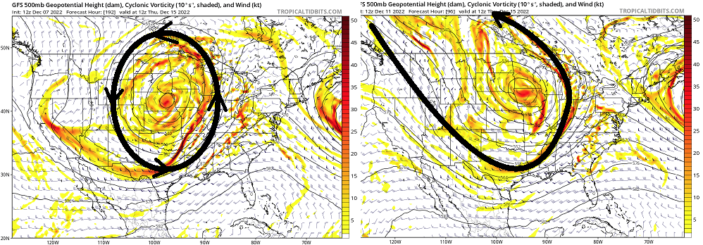
You know honestly .. oy have to glaze some eyes to get this across. But I can see what's happening here with the GFS recent trending... Probably a not in this direction from the other guidance, too. The the GFS has converted the giant vortex look to more of a connected planetary L/W structure. If you center are 108 hours on this 12z run and go back a couple days worth... amid all that noise, you go from that large 'tumbler' idea, to now more of a L/W. And in fact, that L/W on this variation is attempting to torpedo a S/W across the mid Atlantic... This low at 12z and the "somewhat better appeal of recency" is really just a manifestation of the above evolution. Below is 4 days ago, the GFS to now as of 12z, demonstrating that morphology. It matters...because the 12z this morning version would change the nature and evolution of cyclogen. By committing more to the L/W variety, the storm is less likely to be drawn into a W position, because the wave structure remains more open...
-
Ah ha! .... the super detective, "NAVGEM" has foiled yet another crime of model perjury attempted by the ...everyone else, by exposing what's really going to happen with that trough nearing the end of this week...
-
George ... I can see you posting in the slant indicator. I can "feel" you typing the word blizzard. STOP IT nothing I said requires the use of the word blizzard, nor your "clever" ruse to cloak it in a contextual synonym like, "burial" instead. lol
-
Hey man... good catchin' up with y'all last night ... Agreed with the sentiment, particularly as it relates the bold above. My problem ...well, 'concern,' with the guidance is that it is pressed against the west side of the physics ( oh god, what does he mean now lol) - I just mean it can't really go any farther W. A longer detail... read at on headache risk: The whole deep layer structure is trying to move into a region that less really supported at a larger planetary scope. If we look out toward that mid week period, crucially there is a big time -NAO pulse. The situation in the models becomes exceedingly complex, because they have to first be right about that occurrence, then...subsequently, right about how it's forcing influences the surrounding hemisphere. That 2ndary influence is based upon an aspect that has not even yet materialized (that being the first). Boo ya for the models if they get both right - seriously.. A little less likely. It's not impossible. But ... that's what I mean by 'pressed.' I don't like depending on systems in the mid/ext range models that are pressed for any reason - and this one is pressed based upon shit that hasn't even occurred in real time. It's like when you see a bomb on the D7 that is perfect? You know it won't 'last' in the runs because it can't make it through the gauntlet of future permutation - only very rarely do bombs at that range 'survive' the fractal mayhem. This thing may benefit from the same sort of aspect. It's present modeled behavior can't really go much more west, or else the other mass fields et al have to significantly change. Barring the unlikeliness of that super synoptic occurrence ... that means it's gotta fend off any reason to come back SE - which is frankly more climatologically appealing with -NAO burst immediately preceding it, anyway. You're homage to the '50/50' aspect is on point and related there - imho. Murphy's Law aside ( always a risk hahaha) it would be less likely that a D5..6 outlook survives 5..6 days of 'as west as it can'. Having said all that... this thing has a cornucopia of reason to not throw hands, anyway. It's more of 'SWFE' ...which those are notoriously too quick to erode out cold. A reality that emerges often during now-cast, when meso lows along the 925-850 mb warm materialize ...these types of intra event phenomenon are not going to be seen at this range. It's also still real as a storm, and given to the -NAO blocking that is more likely to occur than not, there's climo and common sense (really) to the notion of a colder lower troposphere adjusting the antecedent air mass as we near. Just like this weekend. It was supposed to 42 F as a regional mean today, when this 'little critter' was 7 day ago in the GFS...etc. It is now 24-ish around the region at this 10 am hour, with almost nill means to really get the T even to freezing. Lots of reasons for monitoring. I am not just trying to be contrarian to the populous mood in here ... ha! seriously, if there anything that is less then objective about this analysis, or it's ability to give people headaches ... I will stand both corrected and disappointed...
-
GFS is holding the trough back west and spitting out a more minoring wave … yet another peregrination in this saga. ICON looked impressive aloft but it’s sfc handling is dubiously too warm. It intrudes warm air under mid level heights crashing through 522DM and has it raining …. It’s unlikely to combine those particular metrics without severe thunderstorms and tornadoes -ICON of lunacy is what that is.
-
ahh that's a p.o.s. useless storm... actually know what? For those making the comparison to 1992 - yeeeah... Will and I were mentioning that 'likeness' two or three days ago, just based upon behavior at mid levels. I wrote about that in the scrolled thread that for some reason no one cares about - it's about this storm folks... Anyway, what I was going say is, that storm was all rain in the guidance, for the 5 or so days leading the event. I've told the novella version of that experience before ...won't re-turn the phrases again for now... However, two days before that got under way, it was supposed to be rain. ...by the way, this is the 30-year anniversary ...Dec 10-12th... - I was sitting in History of American Lit ...wanting to jam an ice-pick in my ear canal ..., when the girl sitting next to me was waxing about the models to me, "...I don't know," she said, "this may not be all rain," with an air of ominous to her tone that only a fellow weather dweeb would detect. I encouraged more out of her and she just was saying that the consensus in the weather lab was that it could flip to snow - "could flip to snow". Holy shit was that prescient! They had to 'gut' instinct that call. Honestly, I can't recall precisely what the forecast was for west of 495 (say...). I just remember during the 11th ... people around campus were talking about Worcester presently being igloo-ed under.... I know that was not predicted, either way. Not that. This is the blue bomb time of year... Now, then again in March, with blurry end points. But it's when you get these warm BL that get obliterated by WB and turbulent mixing , height falls ...etc, and then the leading marginal thermal profiles are suddenly -1C beneath the growth region, and then it's caking cotton balls.
-
Well.... which is it? 12 or 24 - cuz 12 sucks donkey ballz. 24's awesome hahaha j/k
-
The GGEM is doing what it is doing for a different set of reasons than the GFS. Coincident results on this one guidance - just sayn'
-
Yeah...this is a great run folks. Perhaps not for the scalar value, but the scalar value in this case bears less relevancy to where this is "likely" heading. The delta(model) is hugely more the focus -
-
Ha... if one is 'reasonable' ? they love it - anything tastes better than that 3 -run excursion just eaten from the GFS. The whole lot of the last ...5 cycles, really demo the model is having excessive difficulty. The continuity has been non-existence as a hint there. Having or not having a storm is not part of that continuity - the details in the synoptics have varied, within a pork job manifold - therein is the smell of BS. - the consumer really shouldn't be purchasing from this particular guidance source until - at minimum - it demonstrates a modicum of continuity.
-
Yeah...I was just gonna say ... I'm not likely as far along the release as you given to my stingy cheapness with hating to pay for petty services, but as of 114 hours, there are certain morphology ( changes in size and shape..) that suggest this would destined better than the recent excursion -
-
jesus my mind... I'm already attempting discrete meteorological analysis and correction techniques, internally. Like, ... as we near the end of the week, the thermal gradient between just 100 naut miles of Cape May to CC, and the I-95 region of the coast, should really be exceptionally steep. And by 'thermal' ..I'm not just talking about temperature. The DP plays a role that is more important in thermodynamic physics when dealing with the gases ...to wit: the atmosphere is a big huge fart ball. Anyway, if a Euro/06z GEFs/06z EPS type blend aloft encroaches upon that area, any low that forms will pack tighter west. If the approach of the jets field associated with that large "tumbler" low ejecting torpedo maxes out ahead of it, crucially coherent would trigger the sfc to 700 mb cyclone manifestation to be W as the "correction vector"
-
Yeah... now that I'm having the chance to tip back a warm coffee and really see these ens mean 'giga' motions and comparing their deltas cross guidance ...blah blah... I'm still encouraged that there's thread-able/credible threat for the end of the week. The 00z EPS and 06z GEFs ( moving bodily en masse back toward the BM ...), as a 'super blend' would be a rank-able impact scenario, and barring comet impact ...probably is real. The operational souped-up version sometimes have a little too much jazz going on under the hood and can blow a gasket once in a while. We've seen it from the Euro, too. I recall the phantom blizzard from NY to southern NJ based on a Euro run with just 48 hours lead sending NCEP into a panic ... 1-3" of wind driven grits.
-
Still a couple pages back ... but if it's any worth, the overnight GEF mean was hugely improved ( for winter enthusiasts ) wrt to this system over the prior mean/spreads.... The prior wasn't as freakishly miserable as the operational 's rather abrupt deviation toward oblivion during those 3 runs... but it was mid way. Don't want to over emphasize here ...but, the 18z GEFs late yesterday afternoon was beginning to side with the operational run, with only a vague impression remaining... escaping seaward. Here is the 18z vs the ensuing 00z Almost smacks as though some bad data got absorbed into the DNA of the handling during the last 3 or 4 cycles, and we've been getting green-eyed babies ...stressing the father's faith and trust in the mother. But the 06z mean leaped quite a bit back toward a major risk avn, with some members in there beneath climo depth, too. Yeah...stating the obvious, also... this is all beyond 120 hours, this last run -away child consternation... Maybe expectations for stability in the guidance isn't proportional to modeling skill.
-
I missed the red eye flight overnight (still back around page 145 or whatever too many this is) but... the morning note was that the 06z GFS made a significant move back in the other direction ... However so telling that is, remains to be seen. In my snark late last evening resides elements of truth ... such that the previous ... I think 3 cycles of that model, the first in the series of which it went from a complete juggernaut on the previous ... to modeling that state of affairs on Pluto, neither of those 3 runs looked very much like the other. In other words, it was a continuity break to leap from the previous into the abandon state, but then it could not establish a consistent vision within the 3, either. So good luck parsing that out before 9 am on a Saturday morning... But upon seeing the 06z solution make at least a paltry attempt to rejoin the pack ... does two things: it pulls away from credibility over the recent GFS runs even farther; makes me yet again existentially question my purpose of being when I'm spending this much time writing about it
-
The only problem with Canadian is that at 156 hours out it’s not quite in its wheelhouse yet. It’ll be into its wheelhouse in another 156 hours. That’s when confidence leaps over 50%
-
I feel like we should be getting a statement from NCEP operations stating that they’re taking the GFS off-line for emergency maintenance If you look at the last three runs across North America the only thing consistent is a state utter entropy. And it’s plate of spaghetti with a different construction to the synoptically layout everywhere on each run. Weird.
-
I'll tell you one thing for certain ... should this freak pattern look go on to verify, there will be no question as to which model was superior in detection.
-
I would argue it's even more sheared in this run, actually.. It's completely rushed into oblivion promptly after 102 to 108 hours....within a day it's completely been destructively interfered down to a shear axis. I've never seen that before. It's as though it has brought the entire Ferril trade band all the way down 45 to 50 N. It has an easterly jet at 500 mb from SE Canada to lower B.C. My personal assumption is these runs are in error ... but who knows. It's an abrupt change ...nooormally that's a red flag in itself, but model wildness isn't uncommon in the extended. Also, the NAO is a suppression factor. I think though doing this, that abruptly on D5 is a little more odd than normal though, particularly when the ensemble mean is divorced from that idea, and cross guidance doesn't agree much either. Strange... some conflicting arguments here, but it seems the weight is against. That above is about as suppressed as is imaginably possible within Terran physics - mooshed to non existence.
-
That would be amazing for winter enthusiasts if that extended worked out after the storm… Transitioning into a monster negative EPO with massive cold load into the Canada … Solid moderate to major snowstorm followed by protecting cold Even hints of a multi stream phased solution rotating around if the 10 were allowed to extend longer. It’s always on D10 tho that’s the rub
-
Yeah that’s the one I think I was thinking of that one way back in the day. Ha. Weird But I just have all kinds of abstract memories of other ones too
-
I’ve also referred to these as ‘Minnesota squeeze’ which I have since the days when college was useful to society … It’s basically whenever you get a trough eject through the west and it runs into resistance and can’t curl up into a Canada as cutter… they usually don’t make it though… They start to pancake and open up as they approach the Ohio valley often times still enough to give us an over running mess or perhaps a New Jersey model redeveloper. Like Will or whom that was just said said though the euro just has an absolute shit ton of mechanics and momentum it’s got to deal with so it ends up stem winding. Yeah I would definitely take this model with a grain of salt at this range because it tends to over amplify beyond D5s , and this whole scenario is giving a carte blanch to exercise its native bias. It’s almost like ecmwf.org called up George and ask him what the model should look like today… He told them the end of civilization as we know it of course but … they decided that was a bit too out there so we got this compromise.
-
I also think this pattern as a hemispheric scope between day 4?and roughly 10 is modeled to enter a rarer type of set up… perhaps even unique. Maybe a tad of “uncharted waters”!there
-
I’ve seen it before… I’ve been referring to it as a “tumbler” during the day for fun.


