

Typhoon Tip
-
Posts
44,236 -
Joined
-
Last visited
Content Type
Profiles
Blogs
Forums
American Weather
Media Demo
Store
Gallery
Everything posted by Typhoon Tip
-
unfunny
-
If the EPS comes around on this Mar 4 ...it's our next thread, with a caveat emptor on Mar 2 ... though I have a feeling that may start to yield to this one... we'll see.
-
Jesus what a QPF monster that Mar 4 event is on this 12z "deterministic" ( heh we hope!) GFS solution is. Looks like 2.5" of sleet followed by 18" of snow from Steve to Ray
-
00z --> 06z may have started that trend from this particular tool. Offering a little cross-guidance ... unfortunately offers less support, as the EPS seems to be caught between that sneaky Mar 2nd system and this one above... perhaps some noise induced wave destruction
-
Feb 28th-March 1st long duration Miller B threat
Typhoon Tip replied to George001's topic in New England
Agree ( not about the use of the ICON lol) the bigger totals than that. I was just musing a response to the other poster seeming to 'grouse' a 3-6 idea -
Feb 28th-March 1st long duration Miller B threat
Typhoon Tip replied to George001's topic in New England
Heh... 3-6" is a fine for my personal druthers. Jesus it's almost March anyway. It's funny this talk of futility that occasionally gets peppered into various contexts ...when the 'seasonal' futility is already happened - Don't forget, winter can fret and fright its hour upon the stage ... the July curtain call is still coming. heh -
Feb 28th-March 1st long duration Miller B threat
Typhoon Tip replied to George001's topic in New England
More than that... It snows probably 5" in 7 hr as a mean distribution away from marine taint ... then another tortured 1-3" over many hours in that run -
Feb 28th-March 1st long duration Miller B threat
Typhoon Tip replied to George001's topic in New England
Muah hahaha... how to create a big chicken salad out of a scenario turning simultaneously into chicken shit...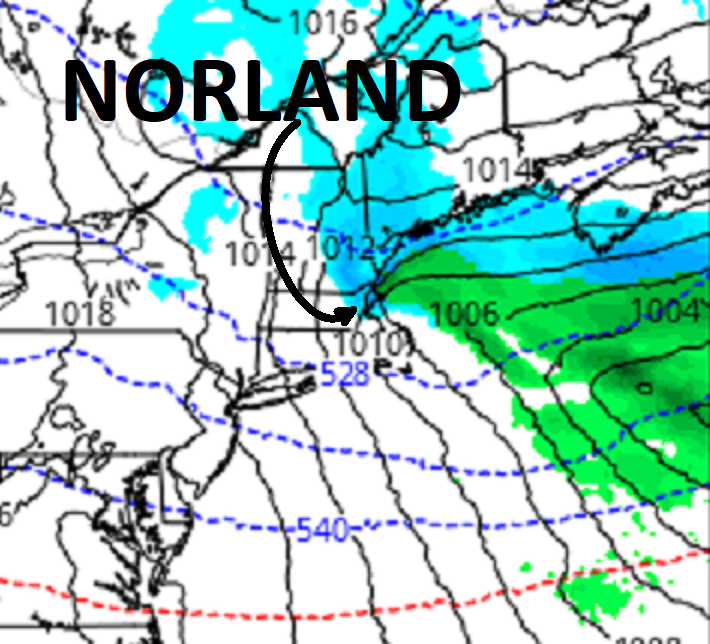
-
Feb 28th-March 1st long duration Miller B threat
Typhoon Tip replied to George001's topic in New England
The ICON is converting this thing into what we just had...only farther S ( axial)... hey, that puts a snow event in the area. It's also got this lasting as mood snows after the IB aspect... it snows for 18 additional hours in S- bursts between that and the N/stream S/W that's racing to catch up. -
Feb 28th-March 1st long duration Miller B threat
Typhoon Tip replied to George001's topic in New England
Bingo! been hammering these two facets since this "top 10 blizzard" thread was decided the appropriate pin version for this event - eh hm... -
Feb 28th-March 1st long duration Miller B threat
Typhoon Tip replied to George001's topic in New England
I can save you some of that consternation by summing up the reason in a simple facet: that's how many ameliorate their own angst. Slightly longer version ... it's a lesson we all learn in adolescence and high school ( most of us that is lol). People impugn others for the guilty reflection of their faults. -
That 'not paying attention' phenomenon is also in play wrt to Mar 2, imho. There's something perhaps bigger than a mere 'critter' in there... In fact, the 00z Euro puts almost as much emphasis on that as the 28th system. The 00z GFS, does not to put it nicely. While the GGEM made a big move/nod toward that Euro idea, with a high end Advisory short duration S+. Bottom line, it should be monitored. I warned of this yesterday, to be blunt. Not trying to promote self here, but as I said yesterday - and I am sure 'no one is/was paying attention' hahaha - I have seen this countless times over the decades of modeling life ...where the runs have everyone negotiating their eggs over a storm in a series, probably because at one time it was a big hog out there... But, some middle one ends up being the most important like a 6th seed winning the Stanley Cup. Not saying that is this time, but the phenomenon is applicable to this particular pattern type we are in... fast/progressive higher error/lower performance circumstance. In fact, it probably is applicable to all these damn things. Hell, maybe we could get all three. Yeah, let's do that! Also, the 06z GEFs was interesting for the 4th.
-
Heh... The wave lengths - in the sense of Rosby loading/logistics around the hemisphere - have not shortened really... What's going on is more related to nuanced aspects in this particular pattern evolution/present era. I get why that idea is offered here, and it's not a bad one ha. It's just about 3 weeks too early, and is also a gradual thing - just sayn' I see winds absolutely roaring at mid levels around a -PNA nadir out west, up and over a S-SE isohypses wall, compressed S by a N/stream that is out of phase and more cold-like over the Canadien shield. We do not have shortened wave lengths out through D10 in these runs...
-
Feb 28th-March 1st long duration Miller B threat
Typhoon Tip replied to George001's topic in New England
A comment on the bold, above. The stochastic NAO is the culprit ... More vs less transitive influence by that index's mode tendencies in the runs was/is a very sensitive factor for this. Very subtle variance in the amounts of exertion have backed away, and those ideas of 3 or whatever days ago go with it... When was the last time the NAO bamboozled an outlook - right? This is a moderate event with ( unfortunately ) a correction vector for less. That is the background, whenever transporting a S/W over curved trajectory over a S-SE ridge... into/through a confluence compression. In the simplest sense it's a built in destructive interference factor. This had a higher ceiling as an event, when it had the NAO on its side... one of the few occasions the reputation of that index really has any merit... But pulling that factor back, lowers that ceiling a bit. We can over-come that and get some potency back...but the contributing mechanics are still rotating around S Calif and we may see more of it conserved as it ejects ... -
Same 24 ZR/IP
-
1926 was a coastal as well... This may be the only place on Earth that gets ice storms from nor'easters ... anything to stop it from snowing
-
Feb 28th-March 1st long duration Miller B threat
Typhoon Tip replied to George001's topic in New England
I think it's possible this smears out into another event similar to what happened today. Which... don't get me wrong. I'm not ungrateful ... it's wintry out there for a change. 4" of sand and snow and a blue tinted dusk at 24 F is a seldom scenery this p.o.s. winter.. we have to "de" magnify for one. All systems at D5 are bigger than the are in the near term. That's A. B, no N/stream to phase... C, the whole f'n thing is trying to move into a confluence up and over a -PNA warm anomaly in the S squeezed between cold in Canada = raging boner velocities... It's really amazing these models have that much QPF and holding onto this thing with so much neg head interference crap. But it is what it is... I'll go along with the game if it's gonna happen. But I wouldn't be shocked if we see this start pancaking on us... -
Feb 28th-March 1st long duration Miller B threat
Typhoon Tip replied to George001's topic in New England
Am I gonna go look at this thing and find that it's weaker than the 12z again... ? -
Feb 28th-March 1st long duration Miller B threat
Typhoon Tip replied to George001's topic in New England
Looks weaker to me... not that anyone asked or cares to read that observation... but hey, ICON? who cares The output of this is bizarre in the guidance to me, overall. It does not look like a snowing QPF output we typically see associated with a coastal storm. It's really like today's event - i.e., much more like an overrunning/WAA ordeal. I'm thinking that's because the first half or so of this is in fact a warm advection IB related...but then a wave formulates along the warm boundary ...where ever it does, and then it takes over. It's a question whether we get an ending sort of comma head blossoming for an exit game. The whole of thing lasts awhile, as that WAA sequence transitions into the latter sense... -
Feb 28th-March 1st long duration Miller B threat
Typhoon Tip replied to George001's topic in New England
The NAO is a fickle index, too. It's like the last remaining frontier for discovery in how the f to figure what the f it's doing next. The best laid plans and most brilliant crafted insights are at times sorely just like ...ignored LOL, and some other shit happens. The reason for this - I know you didn't ask for this ... I'm just sayn' - is because the NAO happens by way of the "non -linear wave function" down stream of the Pacific N/A pattern. What that means is simpler than it sounds. One may typically think A--> B--> C--> as the cause and effect chain of events. And they are right, for linear wave function relationships. NON linear is when A--> B has an effect on D ... but not C in between. A similar/analog to help visualize this is in the open sea: rogue wave phenomenon. A sea surface with an apparent orderly 20' swell may suddenly lurch up a 70' monster wave, and the surrounding 20' wave's are reduced in height temporarily while the energy of the monster exhausts. Crude model.. Most of what happens in the atmosphere is both linear and non-linear wave mechanics happening simultaneously in perpetuity... and they are emergent properties out in time, too - which means fractals... and good luck. This is why NAOs demonstrate the stochastic behavior they do... More so than other indexes, that one has a greater non-linearity just by circumstance of where the domain is situated down stream of all that's great and wonderful about our planetary atmospheric system. Having said all this... It's not impossible that its exertion next week is not handled as well as it looks in the guidance from still 5 days away.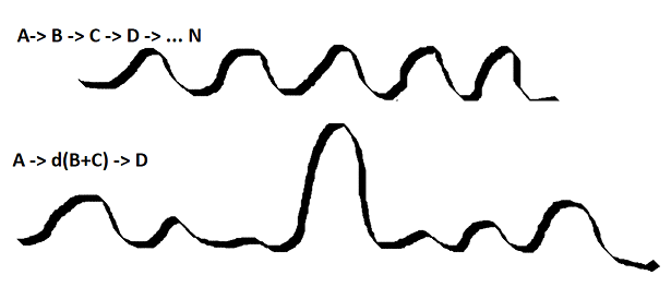
-
Feb 28th-March 1st long duration Miller B threat
Typhoon Tip replied to George001's topic in New England
If nothing else, it's a steady diet of aspects to look at - until very recently, that's been a remarkable challenge, ...unrelenting ennui this winter. -
Feb 28th-March 1st long duration Miller B threat
Typhoon Tip replied to George001's topic in New England
No where near thread worthy ... yet, but the 4th looms. The ICON is setting up a charming scenario in the E, fwinotw.... that model ends at 180 so we don't get to see... ( probably a good thing! lol -) That period still nested in a general index signal, so it has the advantage both that, and having an object on maps. -
Feb 28th-March 1st long duration Miller B threat
Typhoon Tip replied to George001's topic in New England
Yeah ...I spoke of this in an earlier post, wrt model comparison... (Will and I also mentioned yesterday ) The previous Euro run was doing just that - reiterating. It was slowing the field out ahead of the lead impulse, such that the Dakota's S/W was then forced to catch up... But one additional aspect was that also in the previous Euro run it carried a bit more transient ridge expression through the west, too, which encourage the Dakota's S/W to dive more. Both those two facets appear to have backed away since, however. - at least from what I'm observing ... I'm actually beginning to wonder if this is just heading toward something similar to what we are encountering now... It just smears out and ends up an active baroclinic field along the periphery/interface between the southern height wall and the cold Canadian source. -
Feb 28th-March 1st long duration Miller B threat
Typhoon Tip replied to George001's topic in New England
I must live along their standard flight path because they come by in Mig formation all months of the year. -
Feb 28th-March 1st long duration Miller B threat
Typhoon Tip replied to George001's topic in New England
06z GEFs was an important improvement comparing the 00z prior - It's more ominous and cleaner committed to a 2ndary, with several members in the mid 980s SE of ACK. One errant hopeful is 972 near P-town. You know ...should we get a consistent consensus here, we can start considering other interesting aspects ( which we will anyway, who am I kidding LOL ) ... But, the antecedent air mass being cold as Will's pointed out, and high situated N-NE of Maine ..stalled and pinned by -NAO, OES may kick off. It looks like a straight W fetch, but doing so with air that has not actually sat over the water so long that it's been hugely moderated. Also, this whole approach and pivot takes time, so the event finds a way of imposing a longer duration that way. Just some early thoughts on how to get greedy hahaha.. seriously tho


