

Typhoon Tip
-
Posts
44,236 -
Joined
-
Last visited
Content Type
Profiles
Blogs
Forums
American Weather
Media Demo
Store
Gallery
Everything posted by Typhoon Tip
-
I love this affect out there right now... 23 F with just enough wind increase in the last hour that there's 'powdered sugar' lifting off the edges of the eaves. Looking at the temp trends from the various home sites around town, it appears there's been two accelerations: one occurred just post midnight, with an abrupt fall from 31 ... 32 ...to about 28 ... then it slowly shed decimals until 6am when another four fell off. It puts one in the mood to experience more of it... Luckily we have something to track early next week.
-
Feb 28th-March 1st long duration Miller B threat
Typhoon Tip replied to George001's topic in New England
Yeah, they have vastly different solution envelopes for the 3/4th. They do have one trait in common: both a Lakes cutter, and a 'needle thread' bottle rocket coastal with no high pressure over Ontario/Quebec ... are both absent of -NAO help. Interesting.. haven't looked at the index field or numerics - but ...we keep in mind, these runs really have limited value above a single member in any ensemble cluster at this sort of time range. ..Maybe a little. The GGEM ...agreed, that looks more -NAO influenced. There's also a 'little critter' around the 2nd of March. I'll tell ya...we ought not neglect to keep and eye on that. I've seen these types of tortured determinism patterns before, and sometimes as the models tussle over the 28th and 4th ... the "one in the middle" ends up performing better than anyone thought it would. Not saying that is the case...but experienced model users know that that these tools can place too much or too little emphasis on any one wave in a series. All these are over the Pacific. The 28th is in fact currently an 'outside slider' off the California coast. The exit region of those jet mechanics are leading people to think it's onshore, but the ballast of what wind momentum matters to the 28th has to come aboard/round the trough axis as it tunnels onshore as a quasi closed low around 60 hours - so there's plenty of complexity there.. -
Feb 28th-March 1st long duration Miller B threat
Typhoon Tip replied to George001's topic in New England
Pretty spot on ... (I'm catching up ) ... I had this more or less in mind when I started the failed thread, kept the expectation to upper moderate. The Euro was alone in doing that... -
Feb 28th-March 1st long duration Miller B threat
Typhoon Tip replied to George001's topic in New England
Yup, the GFS, GGEM and ICON ( since others seem to be using it...) all cut back some 15 or so % in the 00z. I wrote up a thread for this event, not realizing this one was created - I kept the prospect to "moderate/borderline major" ..which this series seems to gather around, and I'm sticking with it. For now. Firstly the Euro's eye-candy on the 12z was precarious because it was quite dependent on a bit of N/stream infusion, at the time ...out around D5. The -NAO was slowing the east propagation of the main disturbance, and that was allowing a Dakota S/W to catch up and partially infuse. It was really the only guidance source I could find doing that. Could still happen... but seeing it back off and fail continuity doesn't lend to thinking that sort of scenario will play in reality. The other models not having it...seem to coalesce into a consensus rather quickly during the day for an upper moderate event ... but it seems that a weaker total relay off the Pacific is correction - perhaps we are seeing a bit of "magnification" correction too. Incidentally, a latter one in the series out around the 3/4th now airs as more potency in these runs. The Euro Lakes cutters that... So much for the NAO in that model, huh... The GGEM and GFS try again toward more coastal commitment, but they don't seem very -NAO ish either, because there solutions are pretty fast. Not sure what's going on with that index overnight out in that time range. -
ICE BR VIS 1 MI 3" 25
-
Feb 28th-March 1st long duration Miller B threat
Typhoon Tip replied to George001's topic in New England
These early 0Z are modestly weaker overall. -
S 1.5” 32
-
S 1/2” 32
-
32 S-
-
Feb 28th-March 1st long duration Miller B threat
Typhoon Tip replied to George001's topic in New England
George I think you lost a lot of readers when you entered ending blizzard hyperbole to your opening statement… Fact of the matter is an objective measured analytic approach to this does not require the mention of the word blizzard, nor comparisons to history at this time and there really isn’t that much suggestion a very strong winds either by the way - not based on that PGF layout -
Sorry I didn’t realize that there was already a thread running for this.
-
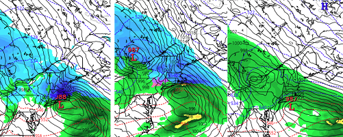
Time to raise awareness... at least than a week's notice This is possible event is rapidly gaining ensemble support, while deterministic version appear to also be formulating a consensus for classic Miller-B cyclone evolution. These are the GFS (18z recent), the GGEM 12z, and the Euro also 12z... c/o Tropical Tidbits. The Euro doesn't carry ptype.... but it's all snow in this image almost down to the shores of the south coast of SNE. These are on the 28th... and don't show the potential quite as far as it can go as a rapid deepening storm type - keeping in mind, we are just formulating consensus. These next several model cycles will be interesting to say the least. Basic synopsis: Primary low climbs toward S. Ontario/St L. Seaway...but runs into a retrograde/transitive exertion from an intensifying negative mode of the North Atlantic Oscillation. The mid and upper air charts as that is occurring then abandon that primary circulation, as the S/W(s) mechanics are forced to dive toward the Del Marva to NYC latitude along the EC - where the canonical explosive baroclinicity resides with the cold continent air ( enhanced by antecedent cold high pressure stalling N. of Maine, also a manifestation of the -NAO/confluence) is proximal to the Atlantic Ocean This changing hemispheric circulation mode is as follows, .. Thus, this is an "index-scale" driven event, one where well-timed disturbance gets "caught" in the instability/restoring along the inflection of that diving curve you see above. We typically find that bigger events are tied so such changes, and often do gather into consensus rather early across guidance pantheon. The reason for that is because the physics of such large, titanic forces have a lot of momentum once they begin to "move", and are thus less susceptible to "noisy" perturbation, that can and do often cause the typical deterministic headaches we deal with with more sub-index events ...that that seldom survive 7 days of model permutation...etc. Aspects to watch for: the amount of phasing with trailing S/W mechanics is in question. The Euro has more of that, such that it's sfc result is deeper and more violent implicated along eastern New England. However, all three suggest a solid moderate/borderline major snow amount, without the monster solution of the Euro. I have seen some snow charts for the Euro model that are ...quite obscene but I'll leave those to y'all to entertain this thread with some of that... What is also not present here is the PNAP pattern. The Euro has more of a transient +PNAP structure ejected through the west then does the GFS and GGEM. That may be why-for it features more phasing with trailing mechanics. Though this event is inside of D6, it is still not quite in the the better model performance range. It's damn close! It is possible that the these other guidance may come around, or...the Euro may go toward less. Also, this event may slow down it's departure in future runs - but that's very speculatively based upon uncertainty as to how the downstream flow continues to "back exert" and slow down the 'atmospheric traffic' - so to speak.
-
it's an advantage at index scaling, ...word
-
Leave amts out of it entirely... adjectives like minor, moderate and major are plenty at this range
-
okay, I thought you meant that for SNE
-
Whaat - I gotta see a graphic for that. 2 feet at this range? - that may be a first
-
This temporal analysis is correct ... but... I'd like to add that it's not really 132 either - it's sooner than that. It's 132-138 hours until it's having a sensible impact... but the formulation of this thing really predates that by a day. The crucial pieces are already interacting by 120 It's one of those situations where if 120 verifies ...the other stuff has to. There's no synoptic way out -
-
in its basic sense ... yeah.. fwiw, the Jan - Apr NAO of yesterwhence; I actually like the subtle relaxation in Mar that year ...such that it wasn't overbearing - 1956 -0.22 -1.12 -0.05 -1.06
-
Well ...just for the record, not trying to start a fight - haha. No but I'm pretty well versed in the generic history of the ENSO, mid last Century to present... I've needed to check it enough that it's just sort of passively in my head. I know that the ENSO was low to moderate NINA for an equally-ish long period of time preceding that March that year. Like 2 or 3 years of it... Seeing as this years ENSO has demonstrated a far better actual coupled state with the larger circulation manifold of the hemisphere, I have a better attitude toward actually using it - haha. seriously though... This: 1954 0.8 0.5 0.0 -0.4 -0.5 -0.5 -0.6 -0.8 -0.9 -0.8 -0.7 -0.7 1955 -0.7 -0.6 -0.7 -0.8 -0.8 -0.7 -0.7 -0.7 -1.1 -1.4 -1.7 -1.5 1956 -1.1 -0.8 -0.6 -0.5 -0.5 -0.5 -0.6 -0.6 -0.5
-
It almost does at that...
-
I can always wait for Piv or TT or something I guess duh.
-
Did you guys do an actual trend comparison 00z to 12z ( eps)?
-
Can we get greedy and ask for 10 .. 15% more mid level kinematics in the breaking wave? Then we'd go from 5:1 year return rater to a historical entry. Who's with me!
-
no kidding ? LOL we're already like Templeton ( Charlotte's Web) ...rollin' around on our sated bellies full of d-dripping model data for the past hour
-
Yep! Not sure there is a very good analog for this/that. hmm


