Typhoon Tip
-
Posts
44,236 -
Joined
-
Last visited
Content Type
Profiles
Blogs
Forums
American Weather
Media Demo
Store
Gallery
Everything posted by Typhoon Tip
-
well they'd better hurry ... Running out of time before they have to just be flat out considered busts... I don't accept in recent tech advancing in these tools ... a day's lead than 'oh, by the way'? UN acceptable. That is a failure That said... were/if folks were 'hoping' cold corrections would continue right on into a snowier solution for us, down here, ...yeah, not impossible. But it was never really on the better side of the odds with this mess. It's still really unchanged to be blunt. Looks like RUT -PWM ~ latitude for snow to me, with IP --> ZR --> cold rain however far it takes to ruin yet another opportunity in this winter of misfits going S.
-
So... I'd definitely pump the breaks in vesting in the 28th/1st and anything afterward - if that hasn't already happened. Models are renegotiating the timing of the NAO, a facet I brought up yesterday as a 'delay' in the onset - certainly the ability of any would-be -NAO to exert over the western limb of the domain. That was a transition new motif as of yesterday, and I noticed immediately ... systems were accelerating in the cinema of the models for the period beyond this 23rd scenario. That change in the circulation exertion has become even more coherent ( unfortunately for the 28th...) overnight. All three, EPS/GEFS/GEPs really don't have enough to suggest the 28th will take either a more S friendly track, or slow enough to get its act together before leaving, any longer. As a result, the GEPs resolves this by taking a primary too far up the ST L region before committing to a Miller B reposition in the GOM. Deep too! At 180+ hours, it's down to 982 as a mean, which is about as deep as can be for a typically noisy multi-member average. But that's too late, and the front side ...not sure a SWFE can result from that thermal layout. The EPS is similar actually...only not as deep. But it doesn't matter - there's a real entity in the flow that will also behave like that, too high for even Central NE before Miller B transition, and to too late to vest in - save perhaps moose-fart NE Maine. GFS ...similar again, but not as deep as the EPS... Same essentially, a doesn't matter scenario as the entity it's managing along ends up too far NW with the primary before it the secondary gets going = too late. All of these solution are responding to the back-off of the western exertion/NAO model, one that was a bit more aggressive/present in the runs prior to yesterday. The solutions they do have, and this is evident particularly in the operational GFS' 06z run... appear cold challenged now, too. That's because said circulation control is no longer there - or removing. Without it, we're losing the mechanism to load crucial cold thickness between successive events. Yeah... all and all I'd say this was a butt boning series overnight ...and another in a long and tiresome examples of why the NAO cannot be relied upon and is also overrated. Aside from the fact, the NAO is actually an illusion in a philosophical way...because its modes are really controlled by way of the non-linear wave function from the flow coming across the Pacific and N/A... so when we look for an NAO, it's really more of a beacon for if the Pacific non-linear wave function is transmitting a signal.. blah blah blah Anyway, long history of NAO bamboozling so not just for the 28th/1st ...I'd also keep all this shirking by the model in mind as we attempt to peer into a March that frankly, I wouldn't be surprised if it hosted a 80F warm burst like DC... In a lot of ways, this current 23rd ordeal and the PV advent ...compressing the field enough to cause it, is really merely interfering with our 2018 redux. And I don't have any faith at all, one can't succeed next month when the sun really is getting cooking and the NAO ( or Pacific...which ever one needs to use ), continues bring winter enthusiasts back from dead, only to send them through this tortured hell of 'it can still happen' LOL
-
Part of me wonders if the next one of these surges won’t have the benefit of an active northern stream in March and will expand much further north
-
It’s likely to “wobble” these same amts, north and south, straight thru verification
-
Especially because there’s a relative min band right there at Ray’s
-
Exactly...and when half the block is actually eclipsing the British Isles aspect of the NW European continent ...how east does it have to be before we can just call it a block and leave it at that... It does start rero motion but not until this month is gone -
-
And what bizarre looking system late on the 26th thru early 27th ... It's cinema has an ANA backside with a deep low out in front. Something tells me future guidance will be morphing that into something that actually typically happens on Earth.
-
Yeah... the -NAO is delaying the last several runs...That's why that GFS is doing that. Prior to about 18z yesterday, the NAO blocking was faster to retrograde, and it was timed so that the 28th would be forced to slow down a bit. Now, ...it's more like Mar 2 .. 5, and that leaves these leading systems to careen east in the otherwise compressed/gradient saturated heights.
-
Considering the variations over the last 24 hours of run cycles...the whole period strikes me as though the physical processes "detect" the underlying index scaled ginormous potential, but the smaller scaled movements over top are doing so, so fast the model can't use one to really exhaust that volatility. It seems like every virga shrouded CU the model tries to run through the 80 to 60W window the model tries to turn it into a 965 mb low going S of NS.
-
It's on my mind.. didn't want to troll the mood - haha... But I did see a graphic a couple days ago that Boston ( assuming really Logan -) was running 3rd place in all-time warmest winters. Also the assumption, that must mean DJF averages. The 2nd place, 2015-2016 was a single decimal point warmer... may be in jeopardy of ceding the tie. I dunno - Also wondering what's the deal with the other climo sites in the region.
-
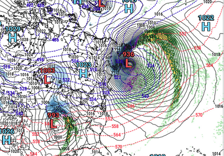
Fwiw re the 28th- Euro is farther N before cutting over to a Miller B. The solution looks odd though. Not sure that's likely... The GEPs, wow what a correction by that ensemble system. Went from a broad ..vague cyclonic curvature with a spattering of members to variable depths, all the way down to 994 mb inside of several closed contours just E of the Cape -198 hrs. It's got several members below 970 mb around Logan... jesus. That's about as loud a signal as is physically possible from this range. The GEFs is about where it's been the last several cycles, though it's been ticking NW overall by small movements. It's more 1000 ...998-ish. Decent.. Haven't seen the 12z EPS but the 00z EPS mean argues the operational is a significant NW outlier overall. It has a classic Miller B transition to S of LI, and it too is 994-ish at D8/9 ...That's also just about as coherent as is ever going to be seen at this range. Just for shits and giggles...it's got one member that's 952 mb about 30 mi W of ACK! actually ...I miss read that. 982 ... maybe 962. anyway It'll be interesting to see what it looks like as 12z
-
So it's sets at 61 in light wind and ample sun... It's a nape factor of 9.5 out there... 60 today, wet snow tomorrow ? Tell me it isn't spring already ... I guess when it's 23 F at 6 pm on Thursday by a raging tucker, that ought send the locals reeling
-
man, that commute Thurs morning is going to be a nasty -
-
I don't think it's even the weather ... It's the cinema in the guidance before hand ...and the excitement impulse of that aspect, specifically... It's quite likely related to an addictive response - that's what it seems to me. But, that said ... so what? it's not up to anyone to attempt to correct that behavior.
-
Ha ha ... thought did cross my mind. Plan on doing 5 mi run outside for a change... But, wake up and it's cloudy tomorrow morning with some wet aggies starting to fall and I'm sure I'll swap out my mood pretty fast.
-
Should we start a new thread for tomorrows "little critter that's trying to bite" ? this is turning into a free-for-all
-
I think what it is is that they are overly forecast. I've seen some flash freezes that moved street slush to turbo grease in 10 minutes flat at regional scale of DPW grid locking emergency crew nightmare. 2003 windex? ..c'mon... people should know this. There's nothing fraudulent about the advent of flash freezing. It's f'ing absolutely real. LOL, I guess you can have 'degrees of fraudulence' ...haha. Like I'd put ANA snow events uno numero on the list of yee-haw model solutions. Then ... I dunno, Norlun as #2 ... down the list is Tornado Watches and D7 1938's up the EC.... Flash freeze I'd put somewhere in there. All these aspects are real - eventually... it's a matter of return rate vs the rate in which humans like to forecast them. hahaha
-
Regarding that ... you know the 00z actually belayed the -NAO ( as well as it's retro trip across the N. Atlantic Basin) until mid way through the first week of March. That sort of disconnected the 28th system ...which I guess we'd sort of chosen as the one? anyway, it was too far removed from it to assess it as a correction/index scaled event ( H.A.). Not to say there isn't an HA signal in play out there...but the runs prior through yesterday were actually better fits for the 28th, per se. But since...the fact that this thing is rocketing E of the Cape in these recent solutions ..tells us that the NAO exertion isn't quite there yet. These runs look more like a bigger dose provide by the Pacific, then they do a retrograde hemisphere.
-
Correct. This sort of GGEM/GFS ( and they are not incredibly different considering the time range + synoptic parameters ) look may in fact be some sort of primitive attempt at an early consensus. The models are attempting to simultaneously evolve a New Jersey model bomb - the old amplifying clipper routine - but having to conserve a very fast velocity base-line flow, that is actually a neg interference. question is, does this or can this slow down on their getting into the 965-975 range upon exit.
-
Good question... Models have improved over the years with low level/BL resolution - to which 'tuck' handling is pretty much entirely within 200 mb of the surface. It's still more likely that even these days, the models are really better at seeing the 900- 925 mb vectors moving cold dense air; From there, its shorter error to the surface because cold always goes under warm. ...which is sufficient for assuming the BD type responses under the 925 level, in the model depiction. But the resolution doesn't really allow an absolute diagnosis of how the fluid mechanics will interact with the surface to say, 1000 meters over the tree tops. Tumbling 'Ekman' layer problem.. blah blah headache later ... once the tuck mechanics get going, the models will be iffy on its strength and termination points because of that 'fuzzy' assessment underneath the 925 mb forcing layer. From that, my guess is if the tuck is actively moving flags and numbing knuckles, it'll go farther S-W and fill in the regions E of the elevation stripes and then crest over ORH ...
-
The dominating forces are the PV, vs the -PNA/La Nina circulation mode Those two have situated ( in the models) a battle ground from Lakes through New England. That's why for the very strong consistency for actually getting an event done - those are largely/physically unmovable compared to the smaller disturbances contained. You know... one school says, you should be grateful and end it there. But no... now that any snow at all enters the discussion, it's hand throwing unfair? wow But beyond that, the gradients are narrowly defined, so much so that mere 'giga' motions in the runs ... less the 50 mi of tolerance even, may dictate if your town gets 5.5" of snow with a crust, or just 1/2" of snow then IP/ glaze ... or less. It just is what it is. Reiterating.. this still looks to me like RUT-PWM is the snow axis. That may get adjusted, but I haven't seen any reason/evidence yet... S of there, it's a gradient to including more IP and ZR to eventually cold rainy teared posters.
-
heh... as of that 00z run it's a "too late" Miller-B haha... actually, that event is the 26th system slowing and stalling/ phasing with other gunk S of NS... It's not actually the 28th/1st event - I'm just clarifying in general. The 28th ( again ..relative to the 00z run), is actually trying to take a flight through Detroit. One thing I'm noticing regarding the operational runs, they are delaying any exertion by a would-be retrograde and/or emergent -NAO, until more during the first week of March; beyond which, the extended GFS attempts the rare feat of retro'ing the anomalies right down into the EC, whilst the -PNA situates a broad trough in the W yet again - if that happens... forget it. I recall the last time we saw a bigger -NAO signal this year ( 'Dec' the halls with balls of Johnny it turned out to be...), there was a series of cycles that attempted this same thing. Q'anon Omega tried to jam it down the winter enthusiast throats... but, of course that type of excessive retrograde did not happen. NAO didn't do much for us though... I really wish people would eat that shit and admit it, too, because I've been pushing for years, the miss-conception that -NAO automatically sends people in a d-drip fugue. I get it that we kinda sorta need it this time, because without out ...we're DEFINITELY fucked. That's relative to this year, though. To me, it's a bit like that old joke where the guy goes to hell. The devil tells him during the entrance interview ... the rumors of hell being entirely unfair are not true, "We actually give the damned a choice as their punishment for being trolls on "American WX' " and on and so on... The devil then takes the douche on a show-room menu gallery of various agonizing horrors for this bloke to decide... Along the expose they come across this curious option. It's a realm featuring a vast sea of naked people, standing in dogshit mid way deep up their shins... But here's the thing, why are they conversing..some even enjoying flits of levity, while holding saucers with coffee cups in one hand, taking bites out of donuts with the other...? Considering all the other horrors on the menu, some so vile they surpass the mordant imagination of mere mortals ... what the fuck, at least there's coffee and donuts. So be it! He finds himself suddenly standing there along with countless other nakeds, in steaming hot dogshit to just above his ankles, with a cup of coffee and Bavarian cream filled Eclaire ...and just when he's about to sip and bite, the booming thundering voice from above exclaims, "Okay everybody, breaks over - back to the push-ups!" Biding time and waiting on an NAO that may or may not help us, is sort of like we're standing in dogshit, as opposed to suffering the no winter at all hell.
-
okay, .. that may have been a conversation regarding aloft - ... honestly, I outlined the snow potential as being along a RUT-PWM line in the opener... That may get dinged by mid levels, it may not... but since snow wasn't really the emphasis down our way, I'm really more interested in testing the vision for IP and ICE ... Snow probably heralds this thing in, either way...it's a matter of timing transition. I admit that I posted following banter, regarding this having S potential still... but at 72 to 90 hours, the models are likely also nearing end point of that.
-
Which threads would those be ? - just curious... because according to my recollection, I have started one thread this year. And it was a system that broke records and wreaked fatal havoc - the scope and specter of which should have had a thread, regardless of myopic intent with this pastime. I dunno...maybe one other. But really, no one has really had much needs to start any event-specific threads. Also... the 06z hardly constitutes the 'the warm move back N' .... the 00z was colder than the 12z ( Euro), and so the 06z ticked essentially that same delta ...the other direction. It may be more indicative of this nesting into a final result. But there is still only so much synoptic room for this to go back N, and in fact, there is still room for it to come S more. I suspect people are hyper focusing on the isothermic layout ...and so the 06z Euro vs the 00z, for 21z Thur ...this difference somehow constitutes a big warm change? Not sure where to begin ... Those differences are far more modest than the melody in here sings. And it was one run.
-
Saw it... yup. The 00z oper Euro tried to remove NS off the face of the Earth with this thing - btw. It backed off quite a bit at 12z though... The EPS and GEFs is a nice cross -guidance appeal, no doubt.