

Typhoon Tip
-
Posts
44,236 -
Joined
-
Last visited
Content Type
Profiles
Blogs
Forums
American Weather
Media Demo
Store
Gallery
Everything posted by Typhoon Tip
-
anyway...jokes aside... still a signal lurks now D8.5 to 9.5 ish... so, it's actually survived the 10 day event horizon. Solutions vary.. The 12z Euro now has it too - so even something like cross-guidance support from the deterministic version. The trick is getting that cross g support when it is 3 days away, not f'ing 9... but we'll see. 18z GFS has 2015 redux... about 30 straight hours of moderate snow in cold
-
Not at seasonal scales unfortunately...
-
GEFs extended mean is alleviating the negative PNA ...but only rises to -.5 or so, into the 2nd week of March. Via Weatherbell. The 'control' run ( code for George stroking his goatee while he pushes a drift switch in demonic laughter ...) has the PNA spiking madly to +2 SD for 3 days before falling back neutral negative way out there... Probably the synoptic version has an 1888 at the apex, I'm guessing but I'm waiting on an email from George before confirming we're gonna die in a blizzard... If it's any help.
-
If they succeed in the first half of that... don't ask me how I know but the 2nd half of that fails
-
Mm case in point ..the 12z GFS' D9 ..10 although the NAO may not be negative per se. Essentially works out to the same rub. I mean I don't have a boat load of confidence in actually getting a wintry profiled ordeal in that time frame, but ...there is a multi-member presentation in the GEFs - whether the scatter is spread out all over hell's creation or not. That's par for the course for 'sub index'. I don’t have anything else as far as I can see… It’s all we got as we sit next to what could be winter’s death bed if things don’t break Not that anyone asked... I'm sort of in my typical seasonal ambivalence with regard to personal druthers that I experience in mid Febs. In one sense, I feel we were jilted by ...something this winter, pretty badly, and are 'owed' in a crazy sense of it. ha! But, we are also out of the solar minimum and one can actually feel that difference. The sun's setting a little later and don't look now, but it's light still at 5:20 pm ... These latter senses start my nostalgia engine for putting this misery away, dusting off and moving into the warm season.
-
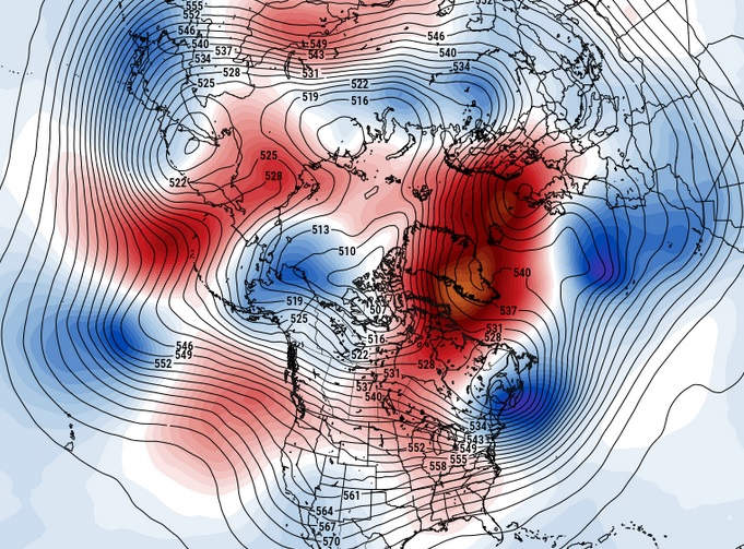
so just to be clear ... ...the conversation tact is predicated on the -NAO assumption? I happen to believe we probably are looking at a > 50 % likeliness to observe a -NAO ... I have a few reasons that I'll gladly gloss over eyes and send readers to Advil if you'd like. I'm guessin' no though, heh Anyway, fwi not w ...the CFS has been all over the -NAO... even west basing it. In fact, some of the runs have been dreaded too hefty, like I was just describing for WW. But cross that bridge I suppose. ...assuming the > 50% gives a return on that investment. heh. Here's March 4 over at pivotal, nicely illustrated a western limb -NAO Should also review a crucial aspect in the NAO. There is quite often a fallacy that -NAO means snow. No. The index in a state of change has a weak correlation to precipitation events over eastern N/A. The PNA, on the other hand, has a strong correlation when it is in a state of change. I mean the papers can't spell it out any clearer, yet we pine around for -NAOs still, clearly as though we place way too much weight on them. Fwiw, my own experience is that a modestly negative NAO, west based, that is being cyclically perturbed ( oh... every 4 days or so..) is more typical for recreating snow potentials.
-
Will knows this ... but 'big blocks' are bad. I suspect he means just getting a coherency in that regard instead of hinting and/or having it be east based or situated wrong...etc. Lot of qualifications really. But a large ridge anomaly sitting over Baffin Island gets into the suppression shit. That is more maddening - to me- actually than what we've just gone through. At least what we've just gone thru we can blame on bad luck. But the compression from a big elephant ass up there, mooshing everything down? That ends up 5 below normal high temps, in constant wind driving dry air windchill nothingness, eternally. F that! for fun I call it the 'elephant sitting on a trampoline' effect. If you can imagine what that would look like. haha. Basically, stretched so tight the flow can't dent? well dents are where the storms form...and so on.
-
If it were me ... I might consider augmenting my approach philosophy if/when seeking any seasonal redemption or wintry event looking forward... The 'pattern' may not be much help in doing so. When referring or relying upon the GEFS or EPS or GEPs averaged wholesale structures..etc, that large scale application means attempting to connect with a index-scaled events: those that are triggered by more obviously recognizable signals. I just think for the time being ( ...next couple of weeks anyway ..), you're focus should be sub-index scaled correction scenarios. Events that "sneak" past those conventions. Case in point ... looking at the charts out there between D9 and 11 .. 12, one may not guess much is very possible or even plausible, with a compressed and very fast interference pattern... However, at the individual member level ( and deterministic solutions notwithstanding), a lot of ensemble members seem to detect enough perturbation in that elephant pattern to ignite an overrunning/ open wave situation. Despite the over-arcing panoply of planetary indexes signaling warmth and an early escape ( BD season notwithstanding...), there is a lot of cold air in Canada through the period, with a subtle tendency to split the flow just enough... The telecon detection grid for the PNA is clearly seeing the negative out there toward week 2. But ...if there is still a modest N/stream coming into occasional confluence, ..yes, even with a +AO ... the cold source would likely bear its presence down to 40 N... Heh, perhaps the only way really possible to get any kind of wintry production out of a +AO/+NAO/-PNA PHASE 3-6.5 MJO, late winter La Nina climo.. but it is what it is... We'll see... keep an eye on that range tho
-
Lake Champlain ice fishing tournament canceled after 3 fishermen die due to thin lake ice“-CNN
-
We'll have to keep an eye on that day 10 range just in case :/ There may be a sub- index scale event in there...it's low prob but higher than the baseline
-
May be a prelude to the seasonal NAO balloon
-
Here ya go... any takers ?
-
Yeeeah, the aspects of that list I provided are seasonal, too, not just sub-seasonal scaled indexes. We're really dealing with ambrosia of multi-dimensional winter killers, frankly. From the empirical calculated EOFs, to the super synoptic "intangibles" and back. It's like a meteverse coexisting and competing for reality. Lol. Anyway, like I said, I've been biding time. In deference to having Canada loaded up with cold, that's really more like agreeing on the hybrid nature of the AO. One has to be careful with any index application, because ( like in this case) this +AO may be idiosyncratic in the way it is modeled/verifies ( spatial layout ) way out there ... +AO can result a warm Eurasia and N Pac, at the expense of a colder N/A ... Just like some -AOs can establish conveyors elsewhere and put N/A on a warm island. It's not always evenly distributed...etc. I mean the correlations are not 1::1 Unfortunately for me, however, I find that to be the weaker signal, and of lower reliance, out of all that avails to the discussion. Nothing extraordinary in saying that - any signal that far out would be, I know.
-
Pretty sure most know my position on matters by now ... but whatever. With this very veracious litany of indicators actually existing and present in reality: +AO/+NAO/-PNA ... ROBUST MJO in phase 3-6 on going and ( probably ) just not as of yet registering a forcing signature (but it may be on the way) ... La Nina climo/springs ... Recent years with these February 'warm bursting' synoptics ... appearing to be independent of ENSO this or polar field that ... and WTF, may as well toss in climate change leaning on everything far more undeniably than the consortium cares to admit ... That looks warm. I just keep waiting for the other shoe to fall, and after a relentless tug of war ...finally, a series of model runs offer up the movie that really should have been premiered already by now: staring some kind of turbo ridge from Hades. I have been biding time out of deference to the Euro and GGEM and GFS with these huge resorvoirs of cold lurking across the Canadian shield. They are bleeding enough of that to roughly 45 lat that we're ending up with this potent ambient hydrostatic gradient ( that looks like March frankly, but even more intense). All that is doing, though, is making the gradient so excessive that these S/W are intrinsically embedded in an utterly hostile velocity shear fest. The Lakes cutter persistence has solid "immovable" fit, too, because that litany of warm cues above may just be like two elephants leaning on each other, and their ass cheek touch along a PHX to DET line. It's just locked in that persistence by two overwhelmingly titanic forces ... (transient -EPOs are the culprit on the other side). I would not say it is likely, but there is a something better than a mere non-zero possibility ...we've seen our last snow this year. I mean I'd put the odds of that at the lower end, but > than most years or the 300 years (irrelevant?) climatological signal.
-
It's also greater SD in the 850 mb level, too ( for those days...) than previous runs. One aspect of Wed/Thur this week re the Euro ( talking to the general audience), it's improved its 2-meter temperature outlook ~ 2 F per cycle going back two days. Perhaps not linear increase, but on average... Synoptically, Wednesday enters contention for 'nape appeal' at this rate, too. It's got a deep layer WSW flow already established, with 850s to +5 by 21z the afternoon. There's likely to be gunk skies around because there's a dying Lakes cutter that's "denting" the field with modest cyclonic curvature ... as it coughs by NW. But if the clouds end up lower in coverage and the winds are light, both possibilities ..., we'll be near 60 despite the 54 MOS/machine and or 2-meter coverage. Thursday depends on sun again... But, the RH at standard metric sigmas are all < 55% ( 700, 500, 300 mbs), so that's an indication there's plenty of that mid day. This is true on the GFS, too. The Euro has also been elevating the 850s on that day, now nicking +10 C by 21 z. Again with deep layer WSW ...by then, very well mixed and likely a taller BL. That's a high temperature of 72 ... I don't believe the 2-meters are representative of a well mixed ( or enough) in any model on Wed or Thu afternoons. And the MEX is definitely too cool at this time of year and range. Given the very warm looking telecon spread as having not really yet fully realized in the deterministic solution sets as of late, ...the subtext to all this is that the correction vector is warmer actually. I'm a just tedious enough about this weather fascination to test these early warm up days, so tfwiw -
-
Probably the same as the number pumps in a Turkish prison
-
Well … that 18Z GFS was certainly no fun for winter enthusiasts. Seriously that aside tho, I’m starting have doubts in anything at all taking place in that regard the rest of the way.
-
You probably know this already so not directed at you per se, but that chart is often misconstrued as meaning that, "warm" or "cool" that's not what that product is indicating. it's there to state there is a 40, 50 ... 70, 90% chance that a region will be above normal, or below normal. It doesn't give any scalar indication of that extreme. It could be .1F above normal in the magenta region, and that's a huge score for that outlook - in other words... That helps in a situation like this... because, that SE ridge is there but until these competing signals give up on the N/stream compression aspect, that above normal is likely to be tainted down by periodic clouds and 'dirty warm sector' ... I'm not trying to bun myself here - what I'm saying is the proper use of that product. If the N/stream backs off... than the "type" of warm departures may feature more in the way of what we associate psychobabbledee-doo to red hues: unabated expansion of the ridge allowing for larger diurnals - typical early spring dry warm burst
-
heh... certainly not around day 10 of that Euro run.
-
The problem with "plausibility" in argument construction is in the definition of plausibility, itself - it seems likely to be true, however "seems" seldom is in any reality that they are used to describe. All of what is typically used to refute climate change may even be clever, when not eye-rolling obviously divisive and/or evasive. However, ...and often escaping the arguer's attention, those uses do nothing to abase or remove a key, fundamental physics constraint: Elevating green house gasses always stores more heat. C02 ( as well as catalogue of other NOX and gas types ..) are higher than 100 years ago, they've got no case. If C02 is higher in point-time B, than it was at point-time A, the space in which it occupies became greater in capacity for storing thermal energy. That cannot be controverted.
-
Sort of ..yeah. The total Sonoran heat release model is - to me ... because I'm a staggering dork - fascinating synoptically. What actually happens is, it is led off by a period of +PNAP. Not necessarily a "+PNA" - there is an important distinction between the two. The +PNA involves the total local hemispheric manifold/circulation mode, from basically the Date Line across N/A. I think the exact coordinates can be found ..etc. But when we say PNAP, we refer to the Perennial North American Pattern. That pattern is described by a modest 'bulge' in the basal flow characteristics, in the heights over western N/A, due to the prevailing westerly flow incurring upon the western N/A mountain cordillera. The flow rises over it, and then the C-force causes it to turn polarward. A standing ridge becomes discernible over the perennial mean. The flow then tapers back S as it's leaving eastern N/A. That distinction offers an opportunity to distinguish 'event machinery' - PNA tied to total atmospheric modes/modality, whereas + OR - PNAP can move with that, or just be transitively influenced ... Similar to the NAO in that respect. The NAO demos more stochastic observation of its mode states because these stem wound maritime bombs occasionally sequence through that domain space ... setting off quickly recovering negative and positive index values. They may not represent the longer term return mode, either... - gets into headaches. So anyway, with the "SHR" ... the modest +PNAP "caps" heat and it cooks over couple of few days... really loading an H850 level kinetically charged layer.. This layer is pretty evident on soundings; often associated with an EML type profiles... but the two can exists independently.. So what happens is, the +PNAP gets perturbed and tries to go negative - if not succeeding. This dislodges said plume of KC8 air ... Given the amount of -PNAP determines the arc in which the KC8 ejection moves down stream... Sometimes it's south through the TV ...Other times it takes the N route - "Hot Saturday"/ Aug '75 was an ejected plume that got caught up and rattled around the N route and came down from the NW. That's why our hottest summer events come from a W or W/NW direction. That whole long-ass sermon above may or may not have preceded the 2017, 2018, 2020 events...etc. It is likely too early in the year to cook up the KC8 layer ..etc. But, we can certainly get a very amplified -PNAP and/or -PNA, that pulls air out of Tx ( for example ...) - 'quasi' creates a weak variation on the same overall theme.
-
It's sooo close to being a legit 'heat burst' - not that there is any kind of formal definition for what heat burst means. I figure it's gotta feel actually really warm, and not just high 'nape' value - not that there is any kind of formal definition for what nape means ... etc etc. LOL. Seriously though, it's a new kind of phenomenon, the likes of which - for me anyway... - I had never experienced in my ...ah, let's call it 'multi-decades' life span. Anyway, its when any winter month hosts a period of summer temperatures. It's obviously less likely in Dec and Jan. Those two months don't have the advantage of the sun leaving the solar minimum era of the total solar calendar - which is the case in February. That's prooobably a prerequisite for this sort of thing. Although, I've seen it be 74 in Dec... once, back in 1999 I think it was. Even if it's only 12 hours... I figure 75 is the fair distinction. Otherwise it's just global warming in the air - haha. Probably shouldn't refer to these sudden synoptic heat plume events as heat bursts, though, as the name is already designated in the AMS Glossary. Thermodynamics are complex, but outflow from convection causes an explosive rise in temperatures - counter intuitive to the idea of cold outflow. But what happens is, the air goes through extreme/rapid drying, and then is compressed. It's more common where mountain topography vanishes out into a lower planar region - I've heard of heat bursts raising the temperature from 55 to 103 in S. Dakota for example... what the f am I talking about. I just wanted a distinction for the 'special' 2017, 2018, and 2020 type summer flash synoptics. That as a specific characterization separates its self from like yesterdays 'historic' aspects.
-
18z GFS a step closer to a real heat burst. I’d say the 2m T over eastern zones to 65 from this range may actually be a nod to 72s with those synoptic metrics between 18z and evening of the 16th.
-
Apr ‘97
-
Agreed... I've been explaining the same facets in my own unintelligible way all winter. i called the 7/8 RMM boundary the "La Nina firewall" for fun. I'll just add couple of aspects. This year's total circulation manifold, other than that ~ 3 weeks post Xmas when Calif got bombed by a Nino river, has been dominated by a well-coupled identity wrt the basal La Nina. I suspect that persistence/bias only decays at the same rate as the winter smears into spring... leaving us with pretty much a complete end-to-end "MJO futility winter". But, there is are competing aspects in the way the local hemisphere ( Date line to S of Greenland) is being handled in the models. In one sense, the right-side RMM MJO is a positive La Nina interference. Combining that with the warm La Nina, late winter into spring warmth, combined with a PNA that's trying to slip negative, etc. These are passive arguments for an early escape. In the other sense, the N/stream is being very aggressive in the means, from all guidance sources as far as I can tell. It's really as though the N/hem is split into a negative interference between the lower and higher latitudes.


