

Typhoon Tip
-
Posts
44,235 -
Joined
-
Last visited
Content Type
Profiles
Blogs
Forums
American Weather
Media Demo
Store
Gallery
Everything posted by Typhoon Tip
-
18z GFS is trying ...sooo close. It's already got an ALB-CON (~) axis in 4 ...maybe 6"... pretty good frontogenic sig, too, so some banding in that swath probably. I think, also, we're battling that aspect I mentioned this morning, re the background pattern might also be attempting to pull the rug out from under matters, too. The trough keeps getting more positively tilted, and "squeezed" from W-> <-E as well. The ridge is the west is also getting more progressive on each run - probably atoning for the compression... Anyway, this may actually be an avenue to getting some snow into the SNE, too, if this flattens out a little more. We'd trade a lot of intensity off for a cold solution. So you end up with oversold 3-5" deal - but that's 3-5" of fun before the Valentine's Day massacre change ( maybe..) sets in. The other notion surrounds the models tending to rush in pattern modulations so...we could see this tip back - not implausible. I dunno... I sense many of us have fatigue at this point. I can mention clad reasons for optimism, and have at times as of late ... crickets. I can mention in equal proportion, reasons to dread and that seems to follow a fervor of statements LOL. .. I get it. I'm objective about this though. Learning to compartmentalize hopes dreams wants and inspirations from aspects of reality, that inevitability dash those in seemingly perfect proportion to exact the sorest butt imaginable, is probably the greatest of all my unsung talents... haha
-
I think he meant snow ... ? I thought Boston got a couple inches -no? First of all, what is considered 'futility'? If it is zero snow at all, that's going to be next to impossible when by policy a flurry under a busted open virga CU counts as a trace. If it is short seasonal totals, ...what qualifies. I think anything under 20" does. But I suppose that's just getting into subjectivity. I'm sitting at 18" ( give or take an inch) for the season, and I consider this futile - to date. Much of the snow that has happened is aggregated < 3" occurrences - in other words, nearly meaningless impact. A winter with so low if not no impact from winter weather ( and mere cold doesn't count), is - to me - by definition a futile trip.
-
Hm -14 F was my bottom temperature during that day and half cold blast, registered around 5:15 am yesterday morning. It is now 49. That is a 63 pt temperature recovery in < 36 hours. You know, I could see this spring hosting another big correction. Some kind of unusually nasty back door event. Late on March 31, 1997, ended an astounding early, historic heat burst throughout much of New England, when a potent BD front brought shock and awe. It was 91 F at 3pm on the UML Weather Lab station monitor, while CAR, ME was reporting 40 KT NE gusts with temperatures in the 30s - not exact numbers but close to it... I've waxed nostalgia over that event before. Needless to say, ... it was 38 F by the next morning on that same monitor under slate gray pall sky out the windows. We know BDs can do it going in that direction... I can imagine a nasty BD air mass with 38 F in Boston in early April, while it's 74 at ALB and 88 at PIT. ...Maybe not the next day, but the day after, it's 89 at Logan with flags waving offshore. There's been notable corrections going in both directions. I've also spun history regarding the late January 1994 day up in Lowell, when a cutter low through the eastern Lakes corrected a dawn reading of 9 F ( 9!) all the way to 62 F with southerly gales, within the same 12 hour span of time. Steam billows rolled off snow banks and piles like Kelvin Hemholt clouds over a mountain range. Not sure which scenario was more impressive, this one, or the March 31 BD in '97. So... looks like the head scratching might come to an end. The D8 + cinema from all deterministic guidance, is finally coming around to the overwhelming telecon aspects. I would not be surprised if a 2017 type warm burst may be trying to formulate out there. For now...not as is. But the background scaffolding is highly convergent in the prognostics. +AO/+NAO/-PNA/MJO in superposition with the longer term Nina climatology/recent decadal precedence for warm bursting in Feb/Mar/Apr... I could see the following D10 synoptic aspect getting more impressive in future guidance cycles.
-
EPS was the most use for winter enthusiasts... GEFs and GEPs, ... not so much. And of these two, the GEPs vs the EPS may as well be modeling a different year - 0 likeness within the Lakes - M/A - NE triangulum. None as far as I can see. Longer op ed ... That, in itself, is unusually highly dispersed even considering it is a cross guidance comparison. They don't "have to" be the same, and typically there'll be some variance, but at D7 ...the weight of the entire ensemble cluster of each "tends" to at least present that they are f'ing modeling on the same planet when it comes to that range. But this... ...is definitely a bit unusual for an entire modeling system comparison to be that diametric. I'm sure it's happened before, but as someone who is fairly diligent in checking/comparing all three, GEFs, GEPs, and EPS... I can say with confidence this is pushing it. The GEFs is just about exactly between these extremes. Anyway, enough of that... The bottom line, this is a scenario next week plagued by two issues, simultaneously: 1 .. Difficult trough handling due to varying degrees of model-self-imposed destructive interference; we can see that with the lead wave vs the aft wave. The Euro cluster puts more mechanically conserved weight on the aft. At the other ends... the GEPs put almost none there, and uses the front side wave almost entirely. Again, the GEFs really looks evenly split. 2 .. I suspect pattern change is also throwing a non-linear ( unseen) disruption with model performance. Folks may not like it - or if they are human, they may even have breached the ''nough is a 'nough' threshold and may even embrace it. I don't know...but all this could go away after this particular threat if the long term global scaled telecons drop the other shoe. That "might" be trying to assert as we head through the next 7 days... It's like trying to finish a building when the scaffolding is changing. In practical terms... the EPS has a better performance record in the late mid/early extended range. Don't quote that.. it is just based on my anecdotal observation in comparing over the years when needed. It's not a hugely better, but edges. The above solution variance ...heh, just a weee bit more than edging difference, though. That's going to be an interesting contest this time. Not sure with the GEFs vs, any longer, as NCEP is "ensemble" ( puns are free!) line releasing new versions of the deterministic, it seems, every 18 months. I don't know if that effects any of the individual members? I don't think so - don't see why they'd need to do that. At a 101 perspective, the intent there is to offer dispersed solutions. Anyway, I wanna say the GEFs may be edging the EPS a little more these days, anyway, jjust because I know first hand that the GEFs went west with the Buffalo Bomb back in Dec before the EPS did. That was kind of an important specter to f-up, huh. It's like remembering a really amazing tasting meal ... except for that fly's wing you found in the sauce. You don't tend forgot such details ... The 12z to 00z EPS was a solid trend in the right direction, with spatial (location) showing exceptional continuity between those two cycles. Also, while deepening ( in the means) the surface pressure. That's like powdered 'construction of coastal', just add water ( ...well, "snow" would be preferred). But as you can see above ...it is situating the low in the climate wheel-house for much of the area. The only draw down in this illustration is that the 850 mb is challenged for cold air... that pesky metric at this range/product typically used. The 00z run/mean cuts the 0c isotherm from just N of HFD to just S of BOS ..with +1 over N CT/RI SE zones... and -1 up to the NH border. That's a marginal atmosphere by definition - weak thermal gradient + or - 0C
-
Heh. three 0Z models … three different evolutions entirely.
-
All you need is just a little more cold and that 0Z GFS coastal’s snow.
-
Presentation overall is here: https://storymaps.arcgis.com/stories/d18edd685e8d46dfba1d16c7673cc9b8
-
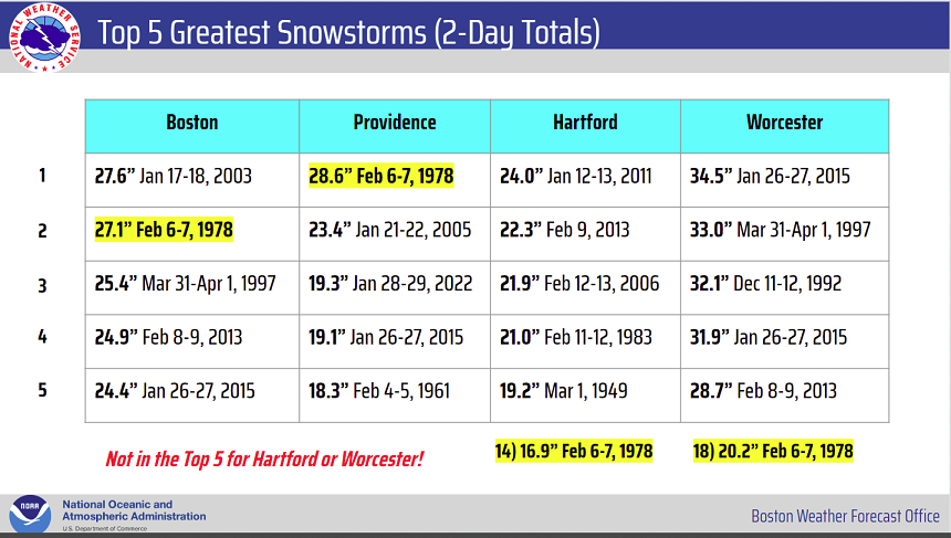
yeah I noticed that, too. But I thought it was more interesting how the 1978 storm - in general - is slipping out of contention more suddenly since 2000. It's probable that it'll last at Boston and Providence but over all, it seems most top 5s are clustered since 2000, with more decadal spread prior.
-
I thought this graphic at NWS ...as we near the 45th anniversary of the 1978 storm, was pretty interesting...
-
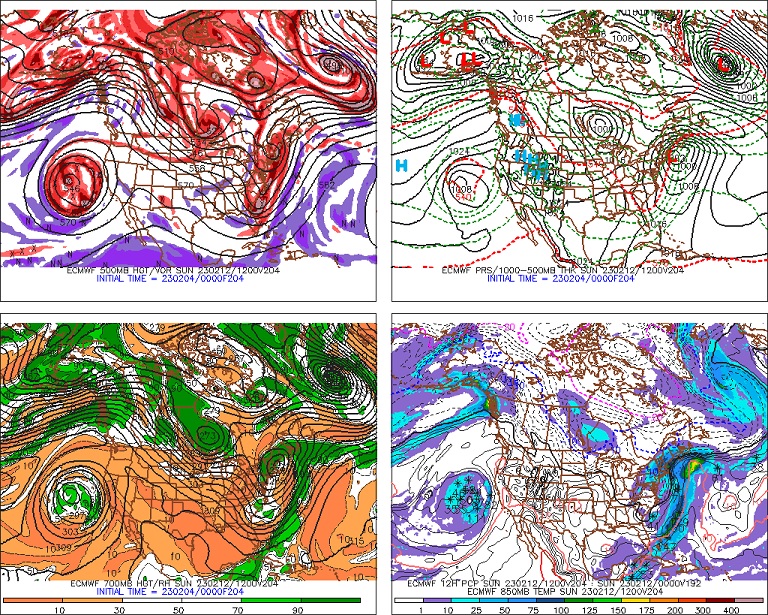
Imho, the bottom two GEF series don't really reflect much support for NOAA's outlook. Those ridge aspects are very transient, and in fact, there's enough individual members with top heavy +PP draped N of the 558 isohypses; as well, that's confluence you see between ~ Lake Huron and the southern tip of JB... It all likelier points to pinning the mean polar boundary S of what those heights might at first suggest. That's A B, I understand why-for the top NOAA prognostics. The longer term climate and teleconnector markers are overwhelmingly converged upon some form or another of a massive SD warm anomaly over the eastern continent. I mean... La Nina climo + MJO's running around 3-6 phase spaces + the warm bursts in Feb trend of the last 5 years ... anything else we can add? These do not protract winter. We just are not seeing it in the dailies ...like, at all! Which is weird. I just wonder if/when the other shoe falls.
-
I'm curious ...
-
It's doing what the GFS is doing ... it's carrying along internal destructive interference; but in the cast of this run, it ends up a big bag of nothing because of it. There is no take away from any run - not last night's 00z or 12z. I elaborated on the 00z run just to parse out what it was indicating for the sake of it alone. There's not much to be gleaned, certainly not vested in the first place, in any deterministic sense of it... The reaction must purely be missing a drug dose in behavior. lord -
-
Yeah...I intimated a similar take on that Euro earlier... I like the fact that it's not a conked out hyperbole bomb, and is taming itself to just a seasonal looking coastal.
-
Not for not .... The Euro seemed to perform best with this weird cold event.
-
GGEM model keeps putting all the emphasis on the lead side of the trough/S/W that's running up through the 10th... The Euro does much less of that. It clamps that response down to almost negligible and waits for the after S/W to rotate around ...and yadda yadda yadda. The GFS has both... It triggers a lead... but then minors it out as a smear, then detonates a new coastal with not enough cold. yeah, solutions are all over the place.
-
Mm...looks unremarkably different than prior runs to me. 'Sides...I need the ensembles to stop sending the system up the St L seaway for starters... The operational runs... okay - but we're at a range whence the oper version may as well just be another ensemble member. The EPS mean did have more a system like it's deterministic version ( 00Z) but, it has a structure that suggests the deterministic version is an intense outlier. Euro has history for amp bias at this range, too. I would say the 00z deterministic Euro is lofty hoped outlier until we see some semblance of agreement coming from the varied other sources.
-
What? that's weird... NCEP has a paper out there about the CFS that says that it has modest cool bias - owing to the fact that it's parameterized with 1988 climate metrics. I posted this along with a link to the paper a couple weeks ago, folks. The opposite of a warm bias, is what they've formally published. It needs an upgrade - in other words ... - to account for climate change. whatever. Either way... it's got like repeating hits out there right through the end of the month. It's also got a dominating pattern construct over the hemisphere that is really quite - ironically - diametrically opposing that of the La Nina late winter --> spring climate. That's odd for a "Climate" Forecast System... but who knows why-for
-
The ICON solution is f'ing awesome... (12z )... I really have come to the conclusion this model does not belong in the pantheon of the majors, based on my own observation of it performance - it's just outclassed. But hey,...I gave the f'er a real chance and it blew it too often. That said, the run in a vacuum has about 3" of sleet and ice for interior SNE, in a waling Nor'easter that would undoubtedly then transition as an exit 6" of snow on top. I'm just sick enough to think that might be a funner experience than having that snow...
-
Ha! I was just looking at that - I applaud your bravery in daring mention that match in this perfect saturation vapeor pressure ratio of gasoline and air mixture ... You got some goodly sized plums there. Lol
-
The event of the season - 2 days of hell!
Typhoon Tip replied to Go Kart Mozart's topic in New England
I was giving this some thought, that 'specific' concern regarding combination - Like I said, the "the advection aspects" - I was including the sustaining wind/gusting as windchill, in that heading and at a regional scale. But as far as at this location/Ayer, there was a nor-easter in 2015 that had 12 hours of winds gusting to 50 mph in occasional milkshake white outs, at 1 F above zero! It went to -5 before coming back after midnight. That's unfortunately countable if doing a straight up comparison. Also, there was other times in that 2015 stretch where we sustained back side advection with single digit cold... So not as deep in wind chill, no, but close...and sustained for many hours. 2016 also had temperatures similar to this in that event, though I don't specifically recall the wind chill numbers in that. So, like I said...I give this one an edge at a regional scope. But it's debatable at this local area of N. Middl. Co whether this is the alpha romeo at in the VIP cold class. I guess in the end it's really a nerds rage, because at civility concerns any of those scenarios of lore would just about be sensibly indistinguishable -
The event of the season - 2 days of hell!
Typhoon Tip replied to Go Kart Mozart's topic in New England
Looks like we bottomed out at -13 here in Ayer. Most home sites accessible via the web are -12 to -14... We've been at least that cold several times over the 11 years ( too long!) I've lived at this location. I'm sure overall this event was historic for x-y-z reasons. There's no intent to dispute. I'm sure someone's frozen to death, or someone's got a 60K burst pipe this or that or the other validating horror... But in so far as what was empirically observed here in N Middlesex Co/W of 495, this was not an "all-time" ordeal. It was on par with handful of bottom miserable cold scenarios. It was certainly an out of the blue and strange one!! The cold on Mt Washington, Boston... and just the advection aspect, too, these were all measured and clad. Together with the overall obviously should give this a distinctive edge at a broader consideration. -
Ensemble mean is instrumental at this range - At least from my position - the discussion is just wrt what the model runs illustrate, on the 00z cycle. I realize people are starved to the brink of sanity for some semblance of a non CC afflicted season ( LOL... j/k), and thus float a thumb over the apoplexy a-bomb button. But there's no aver here as to a D8.5 - 10 ranged scenario. Personally...mm the pattern we are seeing emerge in the ~ 9th -15th window is uncharted territory. I.e., hasn't happened this year. Which is to say, a relaxed flow +PNAP structure occurring while there is lingering/ample hydrostatic gradient, N-S, through mid latitude continent. It may be difficult to do, but I would encourage folks look at events within the period in question more uniquely, as the erstwhile persistence may take a hiatus for that time span. ...probably not...but I thought I'd advance the impertinent implication of actual lucid objectivity, anyway haha
-
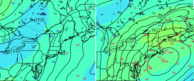
Re the 00z guidance... The GFS picked up where it left off at 18z ( and perhaps priors-), propagating a L/W across the mid latitude continent ...unable to give any one of the finite S/Ws contained a mechanical proxy. This finite scale destructive interference still manages to activate the barocinic leaf and QPF between the TV and NE region, but keeps the totality unable to fully connect with the best perceived S/W timing into the backside of the L/W ... Such that the lead activated axis actually still sets up a substantial ice storm signal along Rt 2 to roughly RUT-CON in NH with snow of unknown amt above, cool rains south... It's basically a busted ravioli system in the GFS... It ends it all as a period of snow collapsing SE as the rest of the trough then limps through consequently too weak with overall cyclone proficiency. The Euro ...possibly owing to the 4-d smoothing tech it applies/scrubs the charts with out in time ... caries a L/W across that has less of that intra-scaled tussle.. Namely, it damps out the lead impulse(s) more, such that the main one coming into the backside can take proxy and is thus able to catch up and physically connect with the b-c axis more proficiency...and the coastal becomes an easy mark at that point - in part because there is just an exquisitely perfectly timed polar-arctic high moving through Quebec as the gunk approaches the M/A coast, underneath. Boom... - in an aside note, the fact that it's not an overly conked out hyper -bombed as a result, but just has a sensible/seasonable Nor'easter in the cinema, gives this particular model run much more Oscar buzz for me...
-
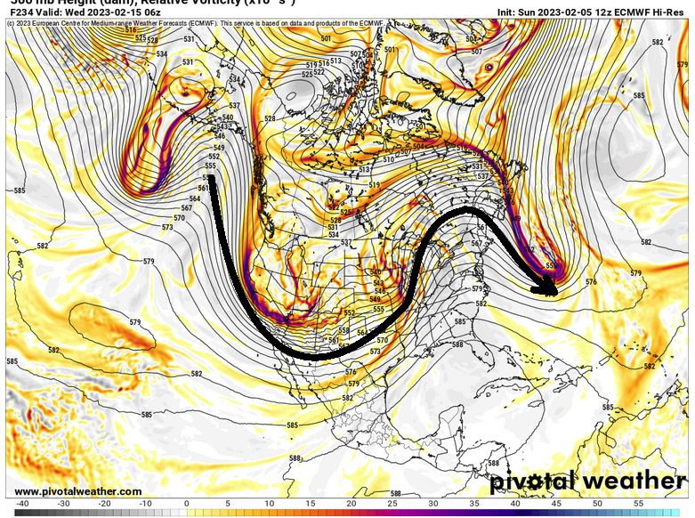
Yeah..not sure what they are looking at ...or think they are looking at - late to party this morning but that 00z Euro run was a classic Nor'easter. Snow NYC-BOS corridor, even penetration E CT RI and parts of SE Mass, with typical flip to rain the Cape... Just talking about this one run, mind you. The 204 position and synoptic metrics are almost perfect in this rendition here: That's probably 8-12" for almost everyone in the forum queue, verbatim.
-
Nasty ice storm central NE


