

Typhoon Tip
-
Posts
44,235 -
Joined
-
Last visited
Content Type
Profiles
Blogs
Forums
American Weather
Media Demo
Store
Gallery
Everything posted by Typhoon Tip
-
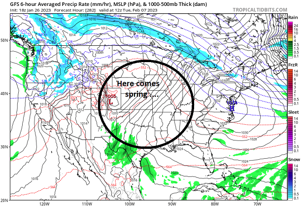
Having passed right through the next 10 days of our only hope by providing no hope, the GFS then says ...
-
yeah ...it's discouraging ... If the antecedent relentless failures this winter were not the case, it'd be less offensive knowing that has to all be the end of these model runs.
-
huh, ...that's the same 4/5th wave the GGEM lifted up, too. Two models latching onto a signal in the D8+ range in 2023 ? that's like a dimmest kid in class winning the chess tournament
-
I don't know if there's any continuity and it's not an aver to any potential but the follow-up wave ejecting wave through the west has promise too - it's got an aft ridge for a change, and the elephant's stampeded off the maps by then... ha
-
looks like the Euro's trying to finagle a S/streamer maybe but yeah ... this N/stream elephant ass routine can go to another planet if it wants to - ugh
-
man... I'd be lying if I said wasn't becoming discouraged by this. This signal is very real but ... it just seems nothing is trending into it - GGEM did ... I guess
-
That extended GFS was really plummeting the AO... Even throws a -NAO bone in the form of a retrograde... I like that for the panache of it. Not huge gradient, while a suppressed storm track, are two factors collocated in time that you'll find not uncommon around the times of bigger events of lore. What I don't like about it ? the fact that it's beyond 300 hours - ... I may also have a problem with being 'checked out' too but would likely be willing to negotiate if presented by the right sales pitch lol
-
Oh it will - we both know that... I've seen these molecular slowing air masses countless times at that range and it ends up ... 70 ... 80% of the magnitude or less worst case, if not half. You know, it's not just the cold waves. Storms too - there's not a lot of real sciency value in the following statement, ...other than perhaps some predictable model error ( maybe), but ...I've come to understand that you take whatever is in a model beyond ~ D5 and lop amplitude off of it. In fact, it's almost like 50% required D10s. .25% required, D5s ... sort of a diminishing returns ratio/ wrt time like that.
-
at this point ? - perhaps puts us out of our misery
-
That's what we used to call a "Montreal Express" ... it's a particularly nasty delivery because it's so direct. There's a little down slope, but other than that - which is overwhelmed by that magnitude of cold anyway... - the delivery avoids the subtle modulation of the continent and/or Lakes from deliveries that arrive first west and then come east. There's not a lot of time or means to moderate the cold plume - it's like hello 60 North! 00z ICONoclastic model had that at the end of its run, but backed off considerably on the 12z. The 06z GFS had it but not as arresting as this 12z version. GGEM has the Feb first week storm ... and really just offers and entirely different landscape in that D8 -10 range. Not sure about the Euro ... All and all, support is technically not so great? but, we are heading into this pattern that's been on the table since the late Hadean Epoch ( it seems...) which can offer either a GGEM or a GFS extreme... Probably - we hope - something in the middle.
-
That spread behavior you described has been a sort of how the longer term results have played out. So, trend awareness alone would naturally lend to that thinking... it's hard to knock persistence, particularly when it is persisting regardless of all super synoptic flavors. It hasn't mattered what ENSO this, or AMO that, or PDOs or Presidencies ...that's just what's happened. We know both existentially, and by the verified numbers ... cold tends to arrive more 'spiky' for briefer stays, returning to a more modest above normal base-state ( we're talking tendencies). That's kind of a crass quick and unpolished way to portray... Still, being -4 or even -6 during 7 days of early February, some how some way ending up +2 on the month is a troll posting boon era. However, there are reasons to go warmer, that are more physically connected to reality than the sniper fire that's sans substantive logic, by someone clearly without a sex partner or much of a life otherwise. La Ninas have a correlation with warmer than normal springs - it may not be as differentiably identifiable last year and year before ... due to a separate phenomenon occurring that's masking it? That's very complexly related to seasonal book-end blocking that's become more prevalent in autumns and springs over the last 10 years - yuck. Other than the Xmas through mid January period, the hemisphere has been well coupled to the Nina. I'm not sure how to reconcile the blocking stuff above, with the a La Nina that may or might not be well coupled as we head through February. But...lurking in the back of my mind is that I've seen it be between 75 and 80 F in February, 3 times over the last 7 or so years. Though here have been some snow events in Marches over the last 10, these warm intrusions have begun taking place with more frequency. Some of these different trends are competing ...both within themselves due to so-so consistency, and against one another. Right now... CPC's analysist are indicating the MJO is constructively interfering with the La Nina, and that favors the warmer eastern N/A in "2 to 3 weeks" as they put it. The numerical teleconnector projections ( I haven't seen last night's) have been consistently showing a shallow +PNA bounce between the 2nd and 7th... beyond which there is this settle back into a +AO/+NAO...neutral PNA that goes off the horizon of those progs. The trends/ n terms = warmer tint, then adding that... it doesn't want to end well.
-
- folks may want to set up their expectations accordingly and allow pleasant surprises, instead, once we get beyond ~ the 8th .. 10th of the month. Prior to that.. there is a signal still between the 2nd and 7th ( or so...), given the numerical telecon coverage and some other spatial/super-synoptic techniques when observing the ensemble means...et a. However, at the moment that signal is favoring more of a cold wave ( if we wanna even call it that) as the main output. Now that the models and means finally stopped fighting one another over this pattern change, what is being portayed is that dreaded overbearing dominant N/stream thing. So much so the ambient hemisphere is a velocity saturated, meat grinding shear machine. Essentially, the large scale circulation metrics end up in a state of reduced(ing) constructive interference. There are events in there, but just as a quick and dirty cursory look, I compared the GFS operational events from 00z, 06z ...overnight, against prior runs, and almost could not find any continuity with space or timing, wrt to specific events... after that frontal passage on Sunday. It's probably more to do with the said fast flow and higher compression - I cannot help but feel if want to track another event again this year, one that is actually worth tracking ... we don't want the N/stream carving out an elephant ass on a trampoline over eastern N/A. So...events can still happen - not tossing the next 10 days or whatever it takes to waste this period ( lol j/k). But perhaps the guidance suites are just going too robust with the N/stream and that would be useful.
-
I have my doubts this cold hemispheric look over the next 10 days is really going to last long enough to proxy February, too.
-
I have my doubts there's going to be any kind of "March" this year.
-
That oughta shore up Washington D.C.'s greater snow season than Boston ... In a + NAO - perfect
-
... mm, keep in mind also.. the end of the GEFs is what, D15 -ish...? I'm not sure what others have in mind, but how long for this world this pattern was supposed to be was suspect - that's not changed. It wasn't going on interminably; there's valid speculation out there that this may not last through the middle Feb period and we'd break the other way. Not impossible that your seeing right through to the other side - so to speak. Just keep that in mind.
-
Either this is one of those ordeals where the radar never looks appealing yet you still get a lot of precipitation "some how," or ... we are not gettng a lot of precipitation out this ordeal. I'm looking at the national rad loop and this thing is 1.5 hours and your done. The entire OV is opened up in a dry slot and the front side of this is rocketing through NE PA at like 50 mph and the whole QPF band is barely 70 mile in width. SO, ...I guess it's going to be interesting to see this system suddenly blossom all the QPF the models have raging through here.
-
Trough ejection through the Lakes is tied to the mode positioning though. I'd think that 2-3-4th is vulnerable... The Euro's leaving the S stream behind and overbearing with the N/stream - it may be right, but I'm willing to bet that modulates in future runs. The CFS has 995 mb Miller A at this range tied to the same hemispheric scale mechanisms - the models is what it is... ( not a statement as to its veracity) but that's a meaty D8+ signal for a climate modulated product, just the same. Yeah yeah yeah the model has a modest cold bias do to needing/lacking updates but the air mass is deeply cold enough regardless of mode source to subsume any such CFS error. The last time we saw an index scaled/mass signal was the Buff bomb, btw - ... just to poke the hornets nest LOL. I don't expect cryo dystopian carnage but I like the signal.
-
Just to be clear - I don't mean to lower guard on event profiles prior to Feb 2nd, out of hand, either. Just that there is risk they'll turn polarward early, given the initial -EPO footprint across the continent. Having said that... we should also elucidate that the 850 mb layout is vastly different after tomorrows event... spanning much of the continental space, E of the Rockies and N of about ~ 35 deg lat. There is also modestly improved confluence if not explicitly in guidance dailies... implied in this circulation mode. What that means is that ... a cutter may not profile quite the same as they have over recent weeks. Best for winter enthusiasts would be to keep those waves flatter and less amplified ( obviously...)
-
There is something suggested in the 2nd to 7th range, though obviously we can all tell from the various recent guidance cycles ... there's some sense that it may be in the earlier part of that range. I don't dispute that, but anything before then ? say 28-29-30 ... I suspect runs into problem with the -EPO response across the continent. The EPS and GEFs means both show a coherent trough amplitude tendency out west, as the heights initially bulge into/over the Alaskan sector. That is not a-typical for d(-EPO)s, but more importantly it can mean cutters. But after that.... the difference here is that there is a more tendency for a "progressive EPO" rather than the retrograde version - that is a critical observation in establishing risk canvas as we run through this ( probably...) lowest nadir this winter has to offer. ... That progressive behavior (modeled) --> +PNA, and though the index isn't hugely changing modes, it is correcting significantly upwards in the numerical presentation/curves, indicating the weight is east bound ... This was true from multiple guidance sources, heading into the first week of February. The models are just starting to sniff this period of risk out as ANA -like miasmas moving parallel or over the eastern continent... It's also possible we miss an index-scaled event in lieu of just a cold wave; it's an option on the table.
-
Seeing as snow is a 'non-zero' level for concern ... ...it seems to me just observing the rad layout over the past several hours, this event is so far west that this initial WAA burst is also too far west to be significant here. It seems the NAM runs that were aggressive in this first sort of pulse ( presently snowing west ) might have been too far E with placement -
-
Just got ridiculously serendipitously lucky up here with this most recent thing…
-
Posted myself several days ago that the 26th and 27th is really when 850 mbar changing of the guard happens across the entire continent. Problem with sniffing out a pattern change 2 1/2 weeks ahead is that it’s an eternity of impatience waiting for that to happen.
-
I had tomorrow’s system in mind when I Hamlin-ed the Euro run. There’s nothing specifically uninspiring with it beyond that. Regardless of any particular model’s present peregrinations … the GEFs derived telecon spread suggests a significant event might materialize between the 2nd and 7th of Feb
-
Yuck...wish the Euro woulda gone ahead and just canceled that run - Lamar Hamlin run...


