Typhoon Tip
-
Posts
44,235 -
Joined
-
Last visited
Content Type
Profiles
Blogs
Forums
American Weather
Media Demo
Store
Gallery
Everything posted by Typhoon Tip
-
Yeah and I'm not sure what it'll mean. I'm not just trying to sow optimism here. It's opening the door to other possibilities, other than a pig primary with coughing secondary ... I also think we're ( no you and me per se but the royal 'we're' ) looking for idealized structures that aren't going to happen this year - to be blunt. Maybe ... not wrt these critters this week, anyway. Still, I think we can "get lucky" on both... How? Monday's event is shaving deg F, as well as inching the rain snow line SE in recent runs. I'd almost argue that we could be icing after a brief snow shot ...particularly when the low is nearing the islands and tucking kicks in - 'just enough'. Not a forecast - just how to make chicken salad out of chicken shit. Then if the parent/ lead S/W becomes less dominant like your saying...we'll see for the next. I understand that down near y'all in SE coast, we're f'ed either way. Frankly, until the arctic air really makes it's present felt/physically exerting, not sure anyone along the coastal plain is going to be particularly UNf'ed until that happens. Last 3 cycles of the GFS has a little critter look along the leading powerful arctic p-wave coming through in a week. Everyone may WINDEX 1.5 to 3" or so out of that....
-
So I mentioned this to Will in a tl/dr op ed a couple hours ago... This 25 ( I guess it is no longer the "26th" ?) event is trying to devolve in the guidance. They've all been weakening, albeit slowly, the system's cyclonic scaffolding as this has relayed into mid range. The 12z GFS is now just 1000 mb closed contour with the primary over NW PA, with 999 mb secondary that is also bumped slightly E of the prior model cycle positions, centered over the NY Bite at 12z Thur. That's all code for continuing to turn this away from a strong cyclonic total evolution.. .but toward what? I'm wondering if this continues to devolve to more of something like Monday's event... flatter wave(s) with overrunning. It's almost down to just being an WAA thrust already. If the primary continues to weaken in the outlook, eventually it'll all just collapse SE en masse. We'll see -
-
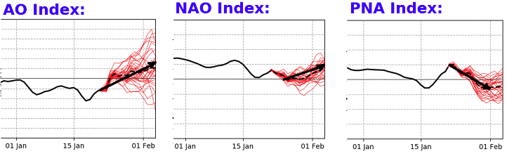
'Throw in the towel' ... Not trying to be condescending or elitist, but I prefer not to venture into such 'emotive' responses to this shit? That likens to a 5 year-old ... flopping in the check-out aisle ... having a tantrum because mom won't let 'er have that piece of shiny candy - that's deliberately there at eye level for the pant-leg grabbing, spoiled little square-mouthed enrage brat. ..But I digress.. I guess there some 'compartmentilization' that goes on with this engagement - within me, anyway. I can have my druthers and disappointments, and my druthers and successes... but I still will approach with the objective analytic intention. I am human, though - but you're asking me a question that sort of delves into my personality a bit. Just trying to be honest... So anyway, there are a couple of points I'd make going forward. 1 ... both education, ranging to existential life, teaches us that it is foolish to 'throw in towels' until ... Easter really. That said, it depends on what one's hoping to experience. If it is heavy stacked snow pack? .... that can't really happen after ~ March 1 do to the obvious. But if one is just hoping for the 'rush' at a great looking series of model runs and the drama build-up of big events... ? That's open season until May. You'll just have to be aware that the return rate is dropping over time. 2 ... Right now the numerical teleconnectors deny everything in #1 ... sorry. I don't make the rules or the correlations - they are what they are. But this panel Would not be encouraging in the climate realm of 30 years ago. It would signify that this pattern change is not long for the world. In 2023, after the last 10 years have sported three separate Februaries that hosted temperatures in the mid 70s, and even an unthinkable 80 F ...?? That panel of teleconnector numerics/graphical presentations should not set very well to any objective consumer. The AO above has a lot of spread. Even though the mean curve is positive, ...enough members are slumped to suggest the confidence chi isn't hugely large there. But every NAO and PNA member is warm in the right panels - and those are perhaps the more important indicators for our latitude. Combing the aspects of #2 above with this telelon spread is pretty much the opposite of an inspiring look for over the longer duration. If one were to say that this winter is "bottoming out" over the next 10 days in particular, after which a some sort of (dying Nina + CC )/2 takes us back to one of those springs like 2009 ...you'd have a strong case.
-
what - not sure I understand this question?
-
You know...at 'local hemispheric scale' ...there's been plenty of cold air this year. Available to systems as they are passing through? That's been the problem - That comes down to in situ mechanics/synoptic variance. That said, ( just pointed this out) the latter mid and extended range is brutally cold across the Canadian shield.. We don't need deliverance from Siberia in either sense.
-
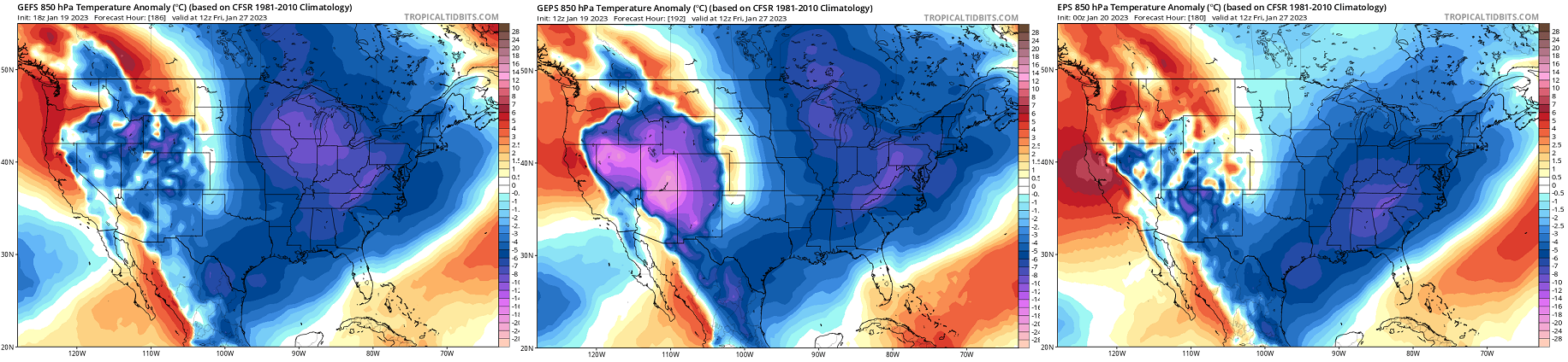
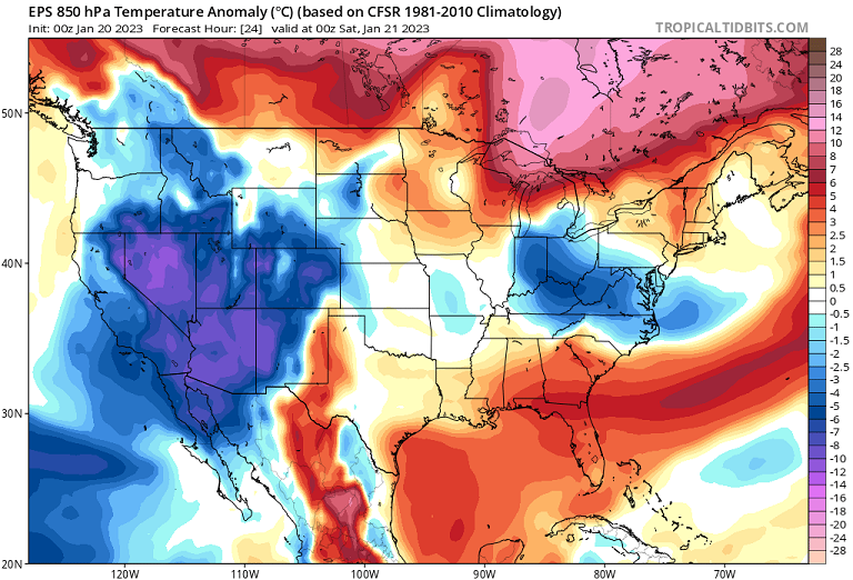
Euro was teasing in the 00z release, too ... but at finite scales. Heh, where only the kind of digging of the desperately damned would reveal. But the Monday system's rain snow line is like 23.4 miles SE of previous runs... It's basically Canon CT to MHT NH... anywhere above that line net gains from that. Unfortunately... anywhere SE is cat pawing madness, net losing what they don't have, where it must feel like god's been raising the dead just to tax them some more. Then the 26th ...has the better front-side air mass like we've been noting, and holds just enough to net gain Rt 2.. Like it snows with gradually diminishing visibility, then right about the moment it crosses the 2 or even 3"/hr rate, pings and pillows take over then it's light rain... BUT, the moral victory is that this system is moving quite fast, so just about the time all that transition happens ( slower to take place from S-N of course... ur right, CNE does well on the 26th), the max uvm passes off and it's misting. That's what that looks like in the 00z evolution to me. Pike might even start as snow and pingers... in fact I think the pretty coloring book versions of the QPF shows that - but transitions to fast to net+ .. One other thing.... these events have been ( as I suspected ...) deamplifying as they've relayed from the outer mid range into mid ...etc. Monday's wave is in fact barely below 1000 mb leaving Cape May NJ shores, where it was once a d-drippin' 978 or whatever that was last earlier in the week. But this is probably why the rain snow line ( in the Euro for ex) is situating the way it did...it's sort of a swap - a flatter system doesn't overwhelm a tenuous polar air mass so readily... They tend to ride along what thermal wall there is, albeit weak. But more so for the 26th, I'm noticing the 500 mb/ wholesale mid troposphere wave signature of the this latter event is in the process of morphing in the runs. It's possible the 26th begins to diverge from a cohesive cyclone model ...devolving into something else... The primary low in the Euro, is over BUF at 1am Thursday at a stunning depth of 998 mb for a reason.. Looks like the whole event is purely a WAA thrust -driven, and losing the cyclone presentation. We may may moral victory that event, just by virtue of it turning into something else entirely. We wouldn't have to suffer the indignity of being raised from the dead yet again on that one. By the way...not sure anyone is paying attention but Canada is loading up with some serious arctic syrup beyond about D7..8 in the GGEM/Euro. 574 closed hydrostat down to mid Ontario is no f'n joke! Pattern must've changed, huh -
-
00z NAM trying desperately to get to an isothermal scenario. Has 0C sfc to 800 mb over Logan at 60 hrs yet keeps that all rain. In the words of count Rugen, “That must be the worst thing I’ve ever heard - how marvelous “
-
4.5” here 10.5” in the season
-
It probably would start as snow everywhere or at least a mix with that antecedent air mass… But how long that lasts would be briefest at the coast and longer in the interior. I don’t think that’s going to Miller B saved the day …there’s just too much mechanics turning N too early inland. That said a residual secondary low that’s having trouble getting going might prolong some ice for awhile from the deep interior southern New England and points north - just an option …unless the deep layer trough en masse evolves further east then we’ll talk about more secondary commitment
-
I was talking about Monday... but, yeah... they're kinda twin events -
-
I'm not sure the track is as important with Monday ... there is a defined lack of cold air.. The track is already doable. In fact, the GEFs ensemble mean was tightly cluster along an ideal track, actually. RAIN sometimes there's just a lack of cold air. Next - That's what this looks like. I keep reading NWS and posts on social media, discussing the track like it is the main sensitivity to where the snow axis is... WRONG there some...sure. But if it's 37/34 at Orange Massachusetts and nothing hanging around in CNE to help out... it won't matter where the 'flatter solutions' track.
-
Posted earlier ...they're having comms problems - they released a statement this morning.
-
what does that mean ... RUT is interior "New England" oh never mind - this was yesterday... haha
-
Fwiw, the 12z GEFs members are tightly clustered with a track SE of the operational, and with a colder profile for Monday. Looks like the 0C 850 mb isotherm collapses SE between 6 and 12z ..ending up PVD-BOS, as the system makes closest pass
-
FYI - SENIOR DUTY METEOROLOGIST NWS ALERT ADMINISTRATIVE MESSAGE NWS NCEP CENTRAL OPERATIONS COLLEGE PARK MD 0532Z FRI JAN 20 2023 ...INTERMITTENT CONNECTIVITY ISSUES... Intermittent connectivity issue with various websites starting around 03Z, including ftpprd.ncep.noaa.gov, and aviationweather.gov, and forecast.weather.gov. NCO support is investigating. Please visit https://www.nco.ncep.noaa.gov/status/messages/ for further updates. Liddick/SDM/NCO/NCEP
-
As of the lull this morning .. 2" on the dot here. That makes my seasonal total very close to 9" We'll see how we stack during the day. Right now, steady light snow has recommenced. 32 F
-
Euro suggested the same thing the NAM is over it's last two cycles, as well. Both are trying sting the CCB, collapsing it back through the region later Monday.. It's likely going to be over QPF'ed if that happens.. but, I just thought it was interesting that they are attempting to do that. Euro version was the more impressive, too.
-
You know ... re the pattern change. I've been watching this aspect that last couple few days in the ensembles ( cross-guidance). It's possible some of the smoldering consternation is also self-afflicted. Why/what I mean by that is, we've been perhaps rushing this no sooner than it was sniffed out as even plausible some 2 weeks ago. That is/was not helping matters. We are/were less likely to manifest any system prior to the 27th as being winter enthusiast inspiring... That 26th system appears to really be an '850 mb inflection' event. Beyond which ...the span of the 40th to 60th latitudes, from B.C. to NS, descends en masse to below normal/negative anomalies. Prior to that, the pattern may be augmenting ( or not...) in the 500 mb isohypsotic layout over the local hemisphere, and in a lot of ways that can be pointed out as being the case - suggesting the d(pattern) is actually taking place... But, I think as far as both sensible/experienced weather, and... being able to manifest systems that are more in the 'like'/d-drip potency ( LOL ...) ...seriously tho, we were not really favorable prior to the 27th, particularly over the eastern continent. Around that date for this flood and mass field significant and deeper change has been very consistent... Prior to this ~27th critical inflection timing ...we've largely been manifesting events in layouts more consistent with this... This latter thermal layout is more apt to present challenges for realizing wintry appeals. We can't walk through a landfill and be surprised that it stinks. The cards are stacked against us... Pick a metaphor. One aspect I am also noticing is that out there around the 30th... there is a bulge of 850 mb temperatures ( more aggressive in the EPS ...which makes sense for it having a meridian bias in that range), where/whence the neutral line gets to about ORD-BOS before collapsing SE. There may be significant event in there. By that time, the cold is established, then that bulge transiently passes through...that's an opportunity. I did take a peek at the individual members of the GEFs and there are several members (below any consensus, still ) that are interesting. But, otherwise, ... that looks like this winter bottoms out in the first handful of days of February - we'll see if the period suffers model "magnification correction" as it nears.

-
I dunno... that 06z GFS was too close to an isothermal hammer over ORH to dismiss Monday's system. The heavier snow axis is likely ~ Capital district of easter NY up through the lower Greens/Whites, but I'd put a wild-card band between that axis and ~ ORH and wait it out through the weekend runs. That's like a single tick from being 6" of dense paste. Threading the needle 101
-
I find it personally interesting that the NAM is like that considering it typically has a Northwest bias at that time range… Really anything over 48 hours yet it’s the most southeast solution
-
00z NAM looked like 3” over metro east
-
We flipped back to rain 2 hrs ago. Once in while there’s a ping or two against the sills … looks like the bigger drops are cat pawing too. I noticed on P-type rad it’s snowing on either side Methuen right now which I find to be rather remarkable.
-
Ha. At present moment … ptype rad indicates it is snowing on either side of Methuen … it’s really quite remarkable
-
When was the last time the NAM scored a coup - gosh...I think back to 2005 really. Not sure I recall since -
-
Just flipped to gritty slush snow here about 20 min ago. Very quickly the roads turned gray and turning corners tries to tale a bit... It'll get slick in a hurry folks. 33. Some kind of S-/R- mixture at the exact moment though.