

Typhoon Tip
-
Posts
44,235 -
Joined
-
Last visited
Content Type
Profiles
Blogs
Forums
American Weather
Media Demo
Store
Gallery
Everything posted by Typhoon Tip
-
Wtf i’m looking at the synoptic charts and I’m not sure I see how it’s going to snow anywhere close to that much south east of about an Albany to Fryeburg Maine line The events depicted here look like they’re moving too fast with shredded out ptypes and amounts
-
Just need that girl, the real reason I even came to this party of dead-beats ... to grab my attention before I'm out of reach and pull me back in. Like that end seen in Something About Marry ..ha
-
I was almost speaking to the straw man ... in the off chance that there are those not clear on the concept LOL I'm half out the door - admittedly ... if prematurely.
-
'now cast' appearance on the entry into this thing ... the snow appears a little more aggressive on various p-type outfittted rad presentations compared to modeling. just sayn' not sure if an obs and amt thread is worth it for this - but ... Looking around ... WPC's current sfc synopsis shows at 16:30 there's a weak cold front slicing through the region. It's hard to detect this in sfc ob/wind profiles, and the DPs are also not very representative, but it is what it is. This situation being very sensy ...it 'might' matter? Right now up and down rt Poop we are generally 37/28 ... Rad with ptype suggests very quickly going from nothing to some sort of light to moderate fall rates, whether IP contaminated snow column or snow. But that's evidence along a line roughly SYR-HFD
-
I prefer to just maintain an objective vigil … But I suppose as an approach to this engagement either method is probably going to end up in the same mentality - semantics. Having said that… gosh, not a good series of runs last night regarding any of these possibilities we’ve been tracking over the next 10 days – essentially in one run the consensus depiction wiped out multiple cycles of trend towards better solutions for winter enthusiast. Such is life in the dreaded needle threader circumstance… which naturally means that there’s some probability they’ll come back obviously It may snow in those systems. But obviously all can see it’s way out towards the capital District of eastern New York up into northern New England… That’s just the winter we’re having thus far, even if it hasn’t performed particularly well N-W, either. It seems the model runs last night just clicked back into the trend of the season… Mm part of keeping an open mind is being open to the possibility that nothing will happen – just sayn’. You know if I have to be blunt even the pattern change itself more so looks like it’s got short legs on it… So others have intimated this over the last couple of days. I’m not sure I disagree. The long awaited new paradigm may limp into the first week of February after which I don’t know. Hm if we really do slip into a negative PNA sans blocking there’s nothing about the last 10 years of climate that suggest we won’t soar into the 70s for another historic run of it next month. We’ll see if an extension corrects in, going forward
-
On a somewhat funner note ... beautiful display of 'Red sky at morning...' earlier.
-
This story still has two chapters. This evening/overnight. Friday. In chapter 1, the recent NAM pulled the rug out on anything very meaningful along the Rt 2 population ..although perhaps better out there toward Orange... The model had shown very solid continuity for about 6 cycles actually, then 30 hours prior to go time, that changed. Not sure continuity principles apply to higher res meso models that are exceptionally sensitive to almost imperceptible perturbation - you can't be sure they are picking up on something real, or eating contamination that's too subtle to notice but having a disproportionately large forcing on the solution. Still I'd like to see one more cycle do this warmer solution. Otherwise, ..nothing's changed above and below that rough latitude. This was never - in my mind - going to show along the Pike. Meanwhile, these changes in the NAM, if they hold ...probably don't mean a helluva lot from roughly RUT-MHT-PSM. The reason I'm citing the NAM so much is because this event had that over-arcing theme of suspicion that it might try to bump N in short term. It is sort of annoyingly predictable, hut ...we'll see. In chapter 2, there may even be a lull early Friday a.m., then we'll have to now-cast where destabilizing lapse rates working in tandem with mid level jet near-by blossom/fill-in rad during the morning. Looks like light snow that isn't very proficiently accumulating, with perhaps a lucky stripe or two that pushes 2-3" ? something like this...
-
00z NAM with .6” liq equiv burst
-
Funny … this was originally supposed to be a Friday thing for SNE. Folks seemed to will Thursday night over the border… If it goes back to original heh
-
That ends up in Buffalo ..but it's a helluva look at this range - ha. "Miami rule" in full effect on that run, too -
-
That's been repeating as theme across the last several cycles, btw -
-
Also - watching for model magnification ... It appears for the events farther out in time, each successive one of them is more powerful than the one before. go wonder - Eventually a monster really will come along ... it will definitely be bigger and more powerful than the one before. Lol. But for now, the succession is suspect.
-
Occasional Thoughts on Climate Change
Typhoon Tip replied to donsutherland1's topic in Climate Change
https://www.nature.com/articles/s41586-022-05517-z -
Better high-pressure expression over Quebec allows for a little more wiggle room there. People still need to pump the brakes on optimism. I don’t like this whole needle threader shit… It’s pissing me off actually
-
26th still looks interesting
-
Looks about the same as 0Z just timing is slightly different?
-
Yeah I was just looking at the synoptics and was going to say that route 2 looks like it takes a pretty good thump Thur on this 12 Z …real real narrow corridor
-
Quite the improvement around the 26 as well over previous cycles. Suggest the operational is along the Northwestern envelope of plausible solutions within the cluster
-
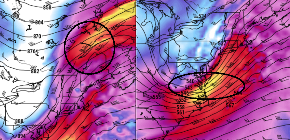
Quick illustration/expo on venting and larger synoptic mechanics ...this system has the classic set up really... One could argue ( maybe) that these two aspects below, could situated a little closer in x-coordinate, but this is a very classic looking couplet with 300 mb evac/entrance jet in New England (left), whilst a powerful 500 mb wind max is torpedoing its exit region into the near M/A/N/E coastal waters (right). The region between these areas will have augmented UVM potential ( lift )... This does not say speak to rain vs snow. It's a pretty common look associated with more vigorous winter storm genesis, everywhere really. But, seeing this is an indication for potential vigorous development, in both degrees of extend and rate of change.
-
This could not be any more quintessentially a needle threading scenario. That ICON solution... regardless of whether the model's a piece of shit or not... is a nice illustration of what that means. That goes 10 miles NW of that track and it's heavy rain a ORH. 10 miles SE, and it light snow there. But riiiiiight perfectly the model runs this thing with exceptionally precise tolerance, along the necessary track to get things interesting between ORH and BED. No problem! put all your money down on the ICON, huh
-
As far as for interior SNE: I don't have a problem with "correction vectoring" the BL colder, "IF" we can verify even a modest +PP CNE ... mentioned that as an 'in principle' concept two days ago. And those can be almost silent, too. It really doesn't take much ... and once the ageostrophy starts up, it can be quite weak but if it feeds into a marginal scenario that's begging for a reason to flop either + or - ... that sensitivity can decide. Looking for almost nondescript boundaries or momentum to suggest -
-
Sub-plot to life... Last year I got a rudely awakening snail mail from N-grid indicating their intent to disconnect me from the grid, due to an arrears mount staggering to 2400$ Umm... how's that? My house is tiny 2 floor, 2-bedrooms, 1-bath, small kitchen and small living room area. That's it. In fact, when you turn up the thermostat, it takes ... 10 minutes tops to raise the temperature from a 54F morning (in winter), to the mid 60s .. 70. It's electric heat - why this is relevant. So yea, with electric heating...I'm going to pay more than just running the appliances. Still, the footprint of this edifice is not that large. Here's what happened... I get offered an astounding .11 kwh rate from some outfit in Buffalo - can't recall their "Enronian" name ( fuckers). I signed up ...because of course I'm also an asshole - it takes two to tango. It was great through the autumn. I was paying like a 150 a month. Then, in December, they sent out a snail mail ( which c'mon! they know people don't check that often any more with an increasing reliance upon other notification closer to real-time ( this is particularly true if you are a asshole!) so they leveraged that). In that snail mail, which I found ...6 months later, they had moved the kwh rate to staggering .36, during the coldest 3 climo months of the year. So I was paying closer to 700 a month to heat and run the home, in totality, thinking that my auto payment of 150 was covering. N-grid finally loses patience come June. They're perfectly willing to cut your power in a low risk summer month - I give then mercy credit there. I immediately converted back to N-grid for supplier. Unfortunately... they sent out mail in September, blaming something having to do with natural gas for why they were going to up their kwh to .28 per. Oy! I don't buy it, frankly. I think these suppliers are in trouble .. not because of supply and demand. Lie. I think they are worried that the future will stem their means to hold society at ransom, because solar at site, and wind and solar at regional scales, et al, is starting to cut into their fossil fuel sourced power grid. That, and... due to legislation already in the works, they won't be able to access FF in 30 years...They are trying to exit trillion the industry as a strategy. But I hate all conspiracy theories unless they are my own, so taken for how little this is worth. Lol
-
Oh yeah - can imagine that's the case with intuitive ease. It's really also no different than a late cold snap -it's the same principle at either ends. Bottom line ...can't refreeze or your refucked
-
yeah it's been remarkably consistent with that axis... I looked at the old FOUS grid. It maintains essentially an isothermic 0C sounding through 800 mb over Logan, with .53" QPF ... hmm.. The numbers were 0C, 0C, +1C, at 980, 900, and 800 mb respectively. Not sure that much QPF loaded through a column like that would necessarily be rain... Comparing those numbers to the synoptic tapestry, it's near-by. Probably that's +2, +2, +4 just south of Logan out along the Pike - first batch... IF IF IF that layout verifies, we probably end up with 6" along Rt 2, ranging to almost nothing along the Pike. That may chap some winter enthusiast asses but ...I don't make the rules of these games.
-
Sun plays a role in that from what conversation with sappers and maple syrup folk. I 'think' that sun warms the tree limbs and that starts evaporation off the ends, setting that into motion.

