

Typhoon Tip
-
Posts
44,235 -
Joined
-
Last visited
Content Type
Profiles
Blogs
Forums
American Weather
Media Demo
Store
Gallery
Everything posted by Typhoon Tip
-
what day and time?
-
I wonder if folks were having these discussions on Jan 14, 2015
-
I agree...
-
It's going to be hard to do much with 23/24 if there's really a west wind thru Ontario and Quebec before it arrives.
-
CNE ski areas probably do well with that IVT/e flow lingering ...
-
Anyway..by a narrow margin the Euro's SWFE keeps it mainly snow N of the Pike... But it's real tight. Like 10 mile wide IP, 5 miles of ZR and then R in CT/RI.. But the cold/BL resistance is working magic ...forcing secondary, and once that happens everything collapses to S-
-
nnno, it's not merely semantics. In regions where it snows, they are going to snow more likely in a pattern that is both numerically and spatially in +PNA, with leading and/or concurrent polar indicators, than otherwise. It's better just to realize it is not 1::1 and not try to cripple the correlation with moderate this or weak that or any of those adjectives. Correlation is not causation blah blah..but it works both ways, and that is why the correlation is not 1::1. The blunt difficulty and frustration here is really that we are rolling bad dice right now, and it is driving people to agitation, to question the conventional method. No matter how articulate we pen our turn of phrases. We can "maybe" offer speculation that CC is having something to do with it ?.. Sure. I actually don't have a problem with that, but that's drifting in the discussion, actually.
-
Yeah...but we're not regressing if we're in a different climate. That's the point. Once we've differentiated into a new paradigm, there is no retrogression in the sense of fixing or 'correcting', because that retro no longer fits the a climate the region is no longer a part of. It's looking at apples and oranges comparing the 1980s to now, really. The results may be the same, the the cause is not coming from the same aspects. So presently it is warmer than normal almost unilaterally year to year, as well ... snowing with a different behavior. We have a higher frequency of big events, ... separated by longer periods of non-events.
-
mm, I wouldn't call the correlation weak. It's just not 1::1.
-
yeah..I dunno. I'm starting to internally materialize miss-givings about the climate use in the discussion. Those 50-60" might be tainted by two aspects;I start to wonder if they belie the 'real' climate? In other words, that 'reason' is defaulting more and more false in this speculation. We are getting 'spike' phenomenon event/eras, more frequently than we used to ... along a mean of more abysmal productivity years. Those spikes are huge, too. Like the increase in the 12+" storm frequency. Or 2015 ..etc. Those skew the averages higher, perhaps - speculation part - more than the "mode of expectation" should really be. You could almost parse out, 'our climate suggests lowering seasonal snow totals, with offset years being much larger still a possibility' - something like this. Which really requires a deeper qualitative analysis than using the 30 year mean of snow... etc... If that were true, objectively it doesn't make a lot of sense to think we're eventually entitled to 50-60" years The other aspect... the climate's been changing fast enough that 30 years may also weight the average falsely, anyway, regardless of 'spikes skewing means as speculation'. I've heard these recent years ...well, basically since 2015, sort of compared to the 1980s? Ah, having lived that decade in full sentient awareness, I can tell you this is different. We are doing so now, when 7 out of 10 or even 8 out of 10 months are routinely above normal temperatures... Regardless of ENSO this, or polar index that. The daily cents in the till, are adding up more proportional to seasonal dollars. Mm...sorry, that barks CC having a hand in matters. I'm starting to wonder if at planetary scales, we might get around to seeing a year that leaps... where its not only the warmest in history, but it does so by more than 10th of a decimal. Just more speculation. I just wonder if our snow climate bands are not really what they presently are.
-
But ... in any case, there are couple of events to monitor in guidance that are not really a part of or immersed in the d(pattern) consideration. 19/20 and ... circa 23/24. ...hard not to assume lesser returns on investment, given the road and unrelenting persistence to do so.. The 18z run of the GEFs mean was probably the best of the EPS/GEFs last 3 cycles, which unfortunately ...nods to the assumption. But we'll see
-
Yeah...never have been myself. The situational synopsis is basically the same. Historically these backing occluded core wrapped gyres are both over sold in model QPF plumes (...verified to have been the case), but there are physical reasons to go lower. There are rare events, but with no way to know if this is one of those... I'd almost argue that relative to this sort of phenomenon, exceeding 3 inches is rarer. ..I'd also be suspect of west penetration, too
-
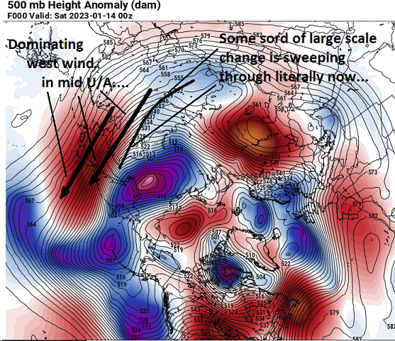
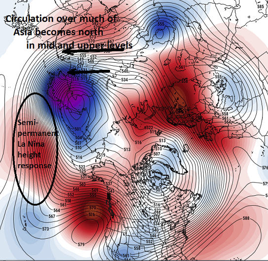
I'm noticing the overnight EPS/GEFs means are converging on the unfortunate west biased +PNA distribution ... ... again. So in short, that bold may be profound advice ( to put it dryly). And I drop the mic like that because it did precisely this upon two other occasions in the Dec blocking era. It's not like there is less precedence to sore-up butts. Longer winded op ed... What is driving that? speculatively, it may be the models physically blending La Nina forcing, up under/in tandem with Asian forced redistribution ( a process taking place now). You can see in the model runs how/why the Pac circulation mode changes, eventually lending to North American modulation.... Below is 00z EPS initialization, and the chart just below is 10 days later... Over the course of these next 10 days, a time in which this pattern change is expected to take place... this all works out to the following look.. The thing is, the La Nina was noted as weakening ...not just speculated by me, but also CPC MJO monitoring published the statement in the weekly publication, last Monday. So what happens? 5 days later and the MJO is almost dead out of nowhere, after it was impressive through phase 8-1-2 for over a week's worth of consistent RMM guidance. It's just pulled the greatest con job from that particular index I've seen. Or, this is typical for modeling pattern changes and getting strange results. I don't know though.. this above looks like a compromise between Nina and Asian forcing, though. Seeing these recent en mass ensemble trends, cross-guidance, putting us back in the west biased +PNA distribution - I don't know if means the same series/redux over Dec, but... that era failed pretty horribly to deliver, when for 3 solid weeks we were immersed in a hemisphere situated with a +PNA(-AO/-NAO). Warmer than normal for the trip, too. We had the one arctic outbreak led by the Buffalo bomb, but it almost failed to get in here - and the arctic outbreak it self? It was colder in the hyperbole meme-machine of mass media. They kept marketing it as "the coldest Christmas" ever - phrases to that affect.. I'm like, "Wtf does that mean. Who cares? Xmas is an arbitrary date along the vagaries of wind and weather" Not to disrespect 44 deaths attributed to the Buffalo event. Deaths can happen in a dense fog in an Interstate pile-up.
-
Nah. Just placating a model one
-
ICON with a decent snow event along Rt 2
-
First GFS run to start nodding toward pattern change ...
-
19/20's in danger of getting damped right out of existence altogether. it occurs to me, the models with more power in that S/W are taking them west...the ones trying to shear it out are south. Just an observation,.
-
God I hope so ... I'm just about out of patience with this winter. I can be objective about modeling and trends, and telecons and ferreting out signals and so forth - it's not that. But if these methods and verification alike keep up with this, I'd be more than happy to put it all behind us at an unusual early exit date. Dust off and move on.
-
wow...what a bomb on that 22nd/23rd ...potentially. That thing bumps east at mid levels by 200 or so miles and that defines the season off any such correction/solution.
-
I've actually been noticing across all guidance actually. Lately the mid and upper air charts don't lend to very good sfc appeals - but then the surface charts have snow chances. I think the pattern change is real...and the models are just fighting desperately to avoid admitting it. hahaha... No but that's not that uncommon with southern height walls while cold loads to the N. I've seen 10" of snow fall along Rt 2 with 70 F NJ in March. So long as we're in a spring pattern seemingly eternally.. heh
-
It's an extraordinary run to look at... That 144 through 168 is almost comical. And I'm not even saying it won't happen that way, but at 144 ... you look at the 500 mb isohypses layout out and there is no way the flow across Canada would physically allow a system to cut. So the Euro reconstructs the entire circulation manifold ..thus finding a pathway to do so.
-
I just also mentioned ...that's the sneaky type of wave that would overproduce. Thinking from memory over the years of modest frontogentically charge mid level collocated over the top of an impressive isentropic lift axis. Nice leaf expansion on sat.. Those can layout a band of S+ that definitely would not be seen at this range.
-
Significant trend to more suppressed track/Miller B response in this 12z GEF's lends confidence to the operational GFS... GGEM also followed suit re the 20th. I don't have a problem with this, given that it is on the interface of the ... a pattern change that is admittedly in trouble, but we are likely to at least register some +PNAP ...if perhaps with a split flow variety. That combined with a slumping NAO does support a southerly track with that middling S/W ... The event it self might cash in on CC pwat and an over ploduction.ha. either way, riding flat waves over SE ridging can pay off.
-
Not that anyone asked but I'm on the fence with this early week thing. I have too many experiences in my decades as a troubled, too oft lovelorn partner of weather to allow much excitement for any "western fringe" phenomenon. That's the canvas I start with. But it's not just tainted by personal experience. There is verified examples. The Euro is not unprecedented for proven a west over-zealous solution. It duped NWS back in 2014 I think it was, with an intensifying hook and latter scenario. With just 36 hours preceding ... it puts out a model run backing 18" snow totals and 55 mph wind gust clear to EWR, sending them scrambling. Blizzard warnings, to cut-ins by the Mayor of NYC warning civility ... 1" of dust. It also has an attenuating amplitude bias, moving events from mid range into short term that is perhaps too subtle most of the time to even notice. But we're dealing with 10s of miles delineating not much to a band of light to moderate snow and/or sleety rain.. heh. It might make a difference at that scale of precision. The NAM? I've been telling this forum community that it's got a NW bias between 48 and 84 hours for years.. I did notice the 06Z GFS tickled back west a little more. It's a fair enough statement that there are examples of backing events, too. It seems they happen, but the western extent ? That specific handling aspect is like IVT snow bands in the mid range - seldom does that ever work out as modeled. It'll be interesting... As the adage goes, there's nothing else to feed the d-drip ( not an adage but it should be )..
-
Not to taint anyone's coolaid but .. this cutting vortex reminds me of a spring/April west Atlantic deal. I've seen that QPF chart many, many times in springs over the decades. And it's always more ominous looking in the charts than what verifies - but we'll see. I could see that being mainly just nasty conditions out side without much else to write home about. The cold is attenuating, and it's whirling over a 50 to 60 oceanic surface down there, so the what's coming off the ocean might not be properly assessing in the runs, either. Just ...I dunno. It's not impressive to me yet. The 500 mb is also filling - btw - during the whole thing.


