Typhoon Tip
-
Posts
44,236 -
Joined
-
Last visited
Content Type
Profiles
Blogs
Forums
American Weather
Media Demo
Store
Gallery
Everything posted by Typhoon Tip
-
I'm amazed that my low here was +31 thirty f one ...above normal. Which, ...you know, if we had a southerly gale type Lakes cutter raging on, we could do that and have in the past. But this? dead calm, open clear skies... That's really something for Feb 16. But a subtlety to that: ..once again, our lows pull the most weight on above normal, when it is above normal... I find this very specific aspect to be both consistent across all seasons... patterns, and permutations in the nature of our weather. The question is, why? It's a fascinating discussion/Q for scientific debate (imho-), though my guess is... heh, given the subject matter, few would engage or be willing to? Anyway, why the low temperatures own the ballast of "above normalness" ...I don't 'think' is a CC issue? Then we'd have to get into how much or little... Like CC may control 10% of that weirdness ...20...30, flip a f'n coin. Maybe it is all connect to DP... yeah you know - is the DP above normal, in all circumstances except for freak direct arctic inserts??
-
We've been slammed shut for temp rise for an hr and half. This cloud density is just enough to cap matters. 56 flat-lined. Looking up stream, most may be on borrowed time with this - not sure this 300 mb milk is going to thin looking up stream.
-
Wait until circa April 3rd, BOS to ALB ... 38/84
-
I don't really wanna get involved in any attempts to either ameliorate the inconsolable - haha.. nor, the attempts to cap the voice of the "trolls" Neither endeavor will ever succeed. It's almost like there are three neurosis involved: Inconsolability; trolling a-holery; those that continue to try and 'fix' either, while expecting a different result. Anywho... having said that, ...perhaps D8-10 ordeal needs to go ahead and actually happen. While it may not stop either of those neurotic engagements ( lol...) altogether ... it doesn't take psychiatric conference to sense it would lower the vitriol. The last two runs of the GFS show more acknowledgement to having +PP built into QUE that is above 1035 mb, ...but more importantly... that is already dammed into the NE regions prior to the arrival of the WAA thrust through the Lakes. That gives it a nod to me. Remove the +PP up there, and the circumstance of it being dammed in here... then I have less issue with a warm solution(s) overall. But, the 500 mb flow and construct over all prevents a true Lakes to Canada escape of that mess... It also is why-for the confluence that produces the +PP... and so forth. That is because the PV is settling into N Canada - ultimately. It seems this battle axis is higher confidence. The question is precisely where that axis forces the east turn. 2 short days ago ...that was S. Even some consistency was going on. But since, it's back N... same consistency. 2 days on ...2 days off... still D8 as of this morning?
-
It's not going away - most likely ... However, the hemisphere is in a dipole state at mid latitudes that is more intense than the normal for winter. Between the positioning of the PV toward N James Bay, late this week through early March, that 10 or so days sets up competing larger mass field indicators. Without the PV ...I personally have no doubts we would truly be doing something in this year to astound the website down to crickets because there'd just be nothing else to say 70+ so frequently we'd put up the first 30 day stretch +30 month in history... Little hyperbole for fun there haha. No, but seriously ... the PV rotating over this side of the hemisphere late this month is not likely to allow mid latitude N/A to warm to the extent that it could, given the antecedent and ongoing -PNA/ La Nina climo aspects... The PV is a cold circulation source. The -PNA / La Nina footprint ( well coupled as it is presently and likely to remain, despite the fact that the index is in fact weakening as we consider it-), are a warm source. What this does is pretty clearly what the ensemble means are illustrating, GEFS/EPS/GEPs, having cold anomalies loading across the Canadian shield, whilst E TX to VA and south see 564 to even 570 dm hydrostats occasionally rolling through the south.
-
Last couple of GFS were more realistic with hesitating BL resistance.. but unfortunately ( or fortunately depending on the druthers) that looks an ice storm for interior SNE...with IP 2" deep down across S VT/NH ... Snow for N country though
-
wow... 52 at 7:30 am on Feb 16 ....under clear skies and no wind.... To me personally I find that an astounding circumstance. I wonder what the 7:30 am temperatures were when we had those unworldly warm days in 2017, 2018, and 2020.
-
the two most trustworthy models known to the technological pantheon, the JMA and ICON models... , both have 22nd bombs leaving our coast... heh
-
Folks should to consider the PNA as having E/W biases - particularly as it then forces the PNAP response. The 1980s had a lot of seasons between '85 and '90 where the PNA --> PNAP had the ridge slightly too far E in the means. Hence the Cape decade... with lots of dry cold waves. This year...it's been west when it's materialized ... I'd even argue that if it goes west far enough it starts eventually reflecting/leaning the index more negative ... but that's an artifact of a fixed domain space, then moving objects around within it. A "true" -PNA really should not have a positive height anomaly rattling around the east Pacific while merely overlapping the west coast - I almost think that circumstance, one we've seen a lot of this year ( and likely doomed the Xmas event to the Buffalo transit ) should be codified as a separate index significance somehow, but that's venturing - Sometimes a neutral PNA is really like a positive PNA that is just biased W...
-
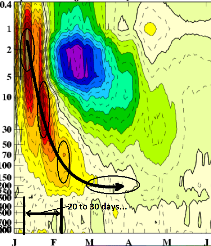
I don't believe the PV slipping off axis and rotating down into the Canadian N is being modulated by the MJO to begin with. There's little use - imho - in drafting causation from the trop Pac dispersion model. The advent of the Marine sub-continental wave propagation over the last 10 days is merely a strong presentation of a wave even, one that was in constructive interference during 3-6, wrt to the La Nina couple based state. If anything the PV behavior in the models is actually in an anti-corrlated state with phase 3-6 ... Now that it is rounding the RMM, the models are detecting the destructive interference of said couple base state, and the wave is summarily - just like all predecessors all year... - not likely to penetrate the 7/8 spacial region, where it actually would be a better correlation for the present modeled PV behavior.... This chain of unlikely correlated events, happening anyway..., doesn't altogether argue that the MJO is really got proxy over the hemisphere.
-
I've been analyzing it over the last week ... It is apparently down-welling in the prognostics of the GFS *courtesy CPCs strat/trop monitoring division. Most crucial factor in assessing it's ability to modulate the mode of the AO, is that downward propagation behavior... 2006 -0.170 -0.156 -1.604(March) 0.138 In this case... the modulation times for early March, assuming an initiation/timing last week? I'm not entirely certain when this particular event got going... The recent temperature monitoring suggests its not even behaving so much like an actual "SUDDEN" event. There's a node that is rotating around PV high stratospheric altitude for over 2 weeks... It almost appears like this is attempting to reach a critical mass loading and then just ends up forcing it's way down that way... I mean, the science of how these works gets the idealized model, but there's probably flavors and hybrid mechanics in reality and not all these events necessarily have to run along according to that idealize behavior...

-
I'm buckin for a 70 tomorrow.. heh. seriously though, the numbers on the NAM grid would support a positive bust over machine guidance ( MOS MET and the MAV for that matter ) at sites like KBED/KFIT/KASH... up our way. Unless your wind veers more S, can't imagine it's cooler down there.. But it has +12C at 900 mb the last several cycles between 18z and sunset tomorrow, with 700 and 500 mb RH fields < 50%... Light west wind... I mean these parameters assert warmer than most 2-meter products post Feb 10 sun intensity, and I like the challenge that happens at this time of year, where it's predictable both that the MOS coverage will lag ...but, human interpolation appears to not have testicles big enough to put up on their graphics... I'd even call 68 at KFIT to KASH a relative win in this regard... We'll see
-
that was intended as pissy sarcasm... it's rectal glue that said, hi res vis sat has clearing punching east pretty fast out of NY. may be a huge diurnal change today? seems both the climb out of the diurnal well, plus a synoptic change sweeping through during the morning might combine for a lot of deg change. we'll see. it always seems in this god forsaken cold anus hole region of the country like the worst of any shit air finds a way compress right against a warm boundary...
-
really soothing and beautiful out there this morning
-
I didn’t think the 18z was that bad anyway. You all just got more nerve than a bum tooth these days. Was less than perfect… ? fine. Uh this is still just a signal and as far as signals go that’s you’re putting a bunch of baroclinic action right through a signal- that’s all you can expect from now. By the way 18z Nam is also 70 over metro west of Boston on Thursday regardless of whatever the 2 m says those parametrics combined with a post February 10 sun is going to soar. West wind open sky 11 Celsius at 900 mbar with low dewpoints and no snow pack. Pretty sure that would be historic numbers a little bit more meaningfully than 58 we put up last week
-
In the near term … that 18z NAM would tickle 70 on Thursday over downtown crossings and parking lots over eastern mass well west of marine kisses
-
we laugh but yeah, the thought's crossed the mind - it's not a bad take Ryan.
-
Euro's gonna lag toward the 24th but it's got the signal big time in the 12z run. I still argue given the accelerating velocity footprint over the hemisphere ...that's liable to quicken pace in future guidance. It's also got a sneaky emphasis being placed on the 21st ... Haven't honestly been paying too close attention to these foreground "shrapnel" ejections in the stream, for actual production - but it's putting some emphasis on that D7 thing ... which I know you and I were keen on that feature as a table setter..etc.... more for the 23/24th
-
..time of the year... It'll do this on day's of this likeness until early August this goes back to 1990s MOS really - as far as I'm aware. Every sunny day that ever existed, where there wasn't a -million SD CAA raging ... ends up above machine numbers. What and why-for that is, ...prooobably has to do with climate normalization, particularly with MAV ext ... But I'm not sure, because the MEX seems to do the same thing, as does the MAV, a mere day's lead, whence there is almost 0 tickery. Brian may no something about the tech as he and I have mentioned in the past.
-
well I mention it only because it may need the attention later in the week
-
Just about exactly where I am in this John Trending in favor but not leaning in just yet. I do feel - agreement with Will - that this has a somewhat different appeal at this point comparing predecessor 'failure's; getting this to augment into deeper cold look, is going in the opposite direction when crossing through the D10's "event horizon" ... it's been a very tricky, unsuccessful time range this season. I mentioned this risk to you in text I believe later Sunday night - the GEFs individual members were 2/3rds in on 'some' kind of risk over eastern mid lat / N/A, though they varied on 'what' that would be. Part of the reason for that - I feel - is related to the sub-index nature of this signal. It's not really tied to a major modal d(index) - this is almost purely driven by antecedent quasi -EPO in a mass field conflict with persistent RNI signal running by underneath. Folks, don't aspect this out as a Miller B or anything like that - though not impossible...This is open wave/duration snow/ice, cold rain layout N-S *IF*IF*IF* and where critical D7 -ish ambient polar boundary lays down... It's all more likely to be that kind of structure - perhaps a nod to that 2015 Feb event for reference...
-
GEFS at 120-144 ... see cold loading across southern Canada/Lakes --> NE is inevitable in that look. If we're setting tables that's your white cloth -
-
Lol ... some of you don't exactly demonstrate a willingness to operate within the confines of personal restraint. I'm seeing a lot of 'huge finish as we thought' this, and 'all kinds of chances now through March' that. That didn't take long! It's like you entered a rehabilitation clinic for a 90 day court order tactile treatment ... passed the screening, and summarily upon release, drove 90 mph to a crack house ... Even if those notions are just in jest, ... just sayn' As far as the D8-11 period - imho - we are still just talking about a signal. There's some subtle attempt at convergence upon an event, but ... it's quite vague. The Euro and GGEM want it closer to D10. The GFS ...suggestion races matters along, and is flatter and weaker around D8.5 through 9. While all the while, these are solutions that are new - in other words, no continuity is established yet...etc... Well, that's not entirely fair for the GFS... it's been carrying an idea better. If I were taking an early guess at 'extended' model performance, they seem to all be operating slaved to their own bias types. The Euro and especially the GGEM tend to end up with more curvature in the field beyond D7 as a general rule. That probably ...or could, I should say, atone for their slower deeper solutions. The GFS on the other hand, tends to a progressive vibe that grows out in time, such that the wave mechanics get stretched and ultimately interfered with - even if only small fractions. All models have a lot of gradient setting up N-S from higher to lower latitudes across the continent in the D6-12 range... so, timing and ultimately intensity/..placement.. .yikes. Beyond that 12 days ( or so...) I wouldn't even step foot into the casino on this one. Good luck. The longer term planetary cues have us doing a 1976 escape this year. In fact, the only reason I can see why we haven't done some kind of attribution scientist's fantasy escape already, is really all coming down to the quasi ( almost non-descript) -EPO forcing that may not even be coherently evident on the charts. But the end result of Canadian cold loading tends to betray that influence... If not for that one ?saving? grace, imho we'd have crockus and forsythias coming to life already.
-
Yes... I was honestly a little worried about this correcting faster. The window for open skies was narrow and precariously timed to begin with, and the local hemisphere's a bit faster at the baseline. Probably need to start thinking about leaning on the front side of spacial-temporal placement where even dependable event tacking in the D5-7 ( assuming we get that far before the white-board effect ... ) tend to end up earlier.... In the meantime, warmth is in general the most fragile of all aspects and seldom does a narrow window for it, survive the larger numbers of model runs - and now we have a 12 hour wind from 6 days out in a faster atmosphere? -right We'll see...
-
I’ve been watching that with the same idea