Typhoon Tip
-
Posts
44,236 -
Joined
-
Last visited
Content Type
Profiles
Blogs
Forums
American Weather
Media Demo
Store
Gallery
Everything posted by Typhoon Tip
-
The operative word ... I didn't like the gradient layout to be honest. Everything else is spot on... it's in the cross-hairs of climatology for biggies in a lot of ways, but... the incidence of the primary not fully filling over upstate NY is creating a 'COL' region in the pressure field, which limits the PGF around the NW arc. In fact, there may not be much wind at all if this solution were to verify, verbatim, out around Orange Mass... But cross that bridge ...I'm likely getting to into the grits for a system that's still likely to change some of that layout in future runs. It does have a tightly wound CCB conveyor ...like a 30 mile wide band of wind from Boston to Providence...
-
I'm pretty sure 1956 works as a partial analog with the preceding global/long turn indicators... although I don't like using index correlations from mid last Century now, when there are so many coherent changes to the way the circulation modes actually behave ...most likely owing to CC... but let's not go there. Anyway, I'm not sure how that fits into the La Nina warm spring climate model either - hahaha. Jesus
-
yeah...it's gone almost immediately once the thing gets cranking.. interesting. In fact, it goes from that to having OES enhancing haha
-
right - 'index scaled' has the benefit to determinism of having a lot of physical momentum in the integration of the hemisphere, that's why big events tend to show up.
-
This needs a "preliminary" awareness thread - sorry, it does. I've seen enough - tell you what... I'll wait it out through the release of the 12z EPS mean... But the GEFs mean did trend, as did the GEPs.... This isn't just the Euro with 2 runs of consistency, it's consistency over top of a multi-sourced, multi-day -NAO situating up there around the climate friendly ( most importantly) cross-hair lat/lon ... NON overly suppressive position. It's also inside D6 as it crossing into the OV by D5, and is very physically integrated into the determinants of the entire local hemisphere. These ICON this and GGEM that's are really not accidents, despite -
-
I see OE warm issues over SE Ma ...
-
technically it's D5.5 really... the formulation of this thing gets going then...and it matures out D6 into 7... but it's safer to move that assessment on the near side of a week. just being fair to synoptics -
-
i'm noticing the a western ridge presentation is becoming factorable ... more coherent in this run but was hinted at 00z ... I noticed that earlier, but figured it too transient and incidental to mention, but this run made it enough to bring it up
-
I'd say it's 5 or so % better in obsessive compulsive hand wringing awareness to isohypses structuring ... hahaha... but yeah
-
so far this Euro run looks very similar to the 12z GGEM thru 120 hrs
-
DP's are chilly though. lot of 40/21's around. The typical 5/9ths ~ WBs at 32 ish.. heh
-
GFS has 3 systems actually beyond tomorrow's fun - on this run... There's a sneaky flat/frontal wave/overrunning signal around 2nd that's got a huge diabatic assists with warm March thickness as far N as PA and continue cold loading above that latitude. That thing could be a half foot for CNE anyway in its own rights -
-
GFS likes the 4th --... that has even more index-scaled appeal than the 28th. Actually, the previous assertion on my part was premature now that look over the 500 mb aspects of these runs. That's more of a needle threading operation aloft, but,...one that appears to have decent antecedent cold like Will was mentioning. So..that helps ( feed-back physics ) in encouraging more S movement.
-
An interesting aspect of the GGEM is it it never changes things over to rain north of Connecticut and Rhode Island… It may not have fully committed to a Miller B but it is far enough along over the threshold that it really doesn’t matter? That’s what it looks like to me
-
GGEM has the more prolific just looking at that QPF products.
-
No you're right... I was and admittedly so, I stated at the beginning that I was intending on giving the model a fair test - I hadn't yet. At the time, some NWS offices began mentioning it in AFDs... I just didn't know; lacked personal experience with that guidance. Honestly, my findings are not that great - mediocre and often just wrong to be blunt. But, having a mode change in a major index field, whilst other models have at one point or the other over the last week ... flagged 28th/1st ... it's more about the 28th/1st than it is the ICON being iconic of pos model
-
OH that's clever. The seldom ever optioned, "I know you are, but what am I" retort - I think I'll double up my therapy apps for next week.. LOL
-
Will ...wasn't throwin' you under the bus, I just thought Ray's exchange was amusing when you followed it up so fast with an ICON post of your own. Both were trash talk, duh - Anyway, the 00z Euro and this 12z ICON solution ( hahaha...) are more back to an index-scaled suggestion. It doesn't make them right, but the idea of a -NAO onsetting mode change has been on the landscape really for over a week... So, it's like we have emerging solutions that have a plausibility - not just noise... We'll see
-
... stating the obvious ... The ICON solution can't happen because it has a band of choke snow 6"/hr rates over Methuen
-
See, everyone ? Will now has a secret ICON fetish ... For now on, we all know that it doesn't matter what 51 members of the Euro suite suggests for a storm a mere 6 hours away, in reality ... it's about what the ICON had for it last week. He's got the lotion and tissues set up awaiting by candle light ... while he pulse clicks on the ICON refresh button like a teenage girl exploring her mouse. LOL
-
heh... I like making fun of it. but, typically on here - anyone posts anything, it's become part of their 'street cred DNA'
-
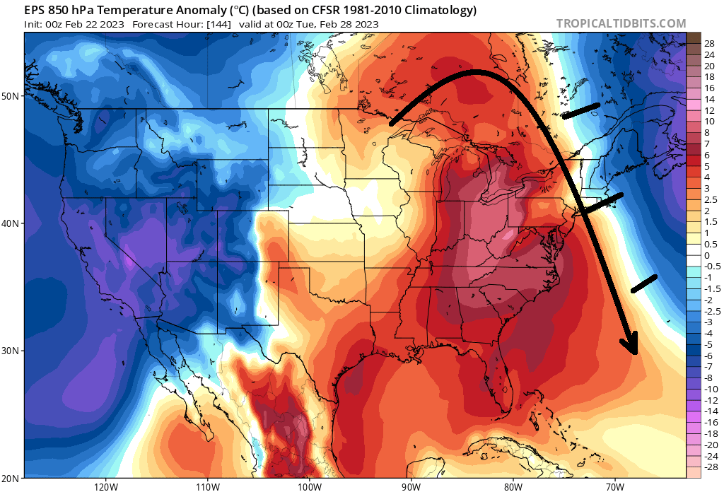
mm, it depends which suite one chooses to side with. The EPS' local hemispheric circulation mode, centered on the same range as these images you've provided above ... would not either allow that type of anomaly distribution you see in the GEFs, ...or if so, it would be deteriorating/normalizing with extreme rapidity Not sure I agree with 'siding' with the GEFs here... the Euro corp has a pretty damn good handle on NAO as a phenomenon over the years - possibly owing to the fact that the NAO's barrel points at that region of the hemisphere with even more scope focus than it does here as a general tendency. ...that prooobably leads them to needing to get that index under control. Just sayn' ..or as much as they can... I dunno. It's kind of like what Megamike was mentioning yesterday ...best to choose a source that's local, over one from the other side of the planet. It's like Earth telling Martians how to forecast their weather - ... fun metaphor. Anyway, here's the EPS 850s for that same frame. Clearly there is a resistance difference in the amount of NAO exertion by the two sources, and that warm anomaly region doesn't get east of the Hudson without attenuation in a Euro-esque proxy... Up to Met and hobbyists to choose I suppose.

-
It occurs to me...this whole ordeal really has moved up by almost a complete 24 hours... I started an obs/nowcast thread, but the title may be miss-leading: it's still focused on the same event, fyi
-
heh... exactly what I was said in my mind when I read that, 'welcome to our spring'
-
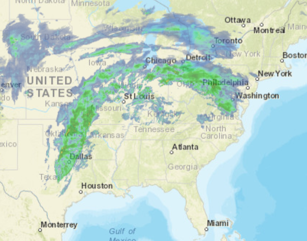
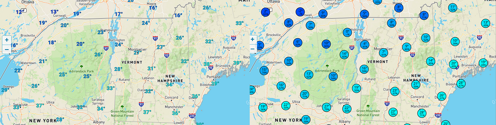
Setting the table on a possibly "moderate" impact winter storm. Perhaps the most promising event to date, this season. Presently... Radar upstream argues for a stronger precipitation loading than some of the guidance have been illustrating. However ... these rad looks can be deceptively over and under suggestive, either way. Therefore, that statement is not an aver for a big deal here...just that at this hour, that arc is pretty potent looking as it advances E into PA and matching that against the axis positioning by the guidance, it's not impossible that just ends up through the region with some higher fall rates. Combining...some of these recent guidances ( last hours) going colder with 200 mb of the sfc, is worth it to mention. Re that: the new NAM solution has almost doubled the Logan numbers, and I'm seeing an uptick out around ALB. Judging by radar return and overall lay-out, this is tentatively a nod to a better performance. While also cooling the column below 800 mb sigma Sat presentation has the abrupt ceiling advancing, shielding the skiess rather abruptly ...already so western regions. T/DP spread around the region looks like this, ..biasing the obs to NW-N regions because this is our loading source for the lower troposphere later this evening and throughout ( particularly) Thursday.