

Typhoon Tip
-
Posts
44,524 -
Joined
-
Last visited
Content Type
Profiles
Blogs
Forums
American Weather
Media Demo
Store
Gallery
Everything posted by Typhoon Tip
-
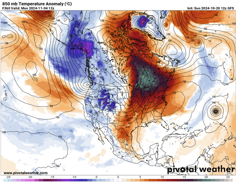
the correction vectoring is pointed away from colder wrt the operational models bullying in the polar jet and driving that scale/degree of cool down from the lakes to ne region over the weekend into early next week. but we'll see. anomalies, relative to the bigger anomaly, is really what 'weather' is. in this case, the larger canvas/hemispheric signal is a whopper heat one. the operational runs are trying to lean into it and argue ... if they succeed, it would be a cold anomaly inside a larger/longer period warm one. but i am seeing a subtle backing off the operational gfs wrt to saturday mornings cold frontal potency and the amount of caa that floods in during the afternoon. 06z came back about a smidge but not enough to abase the lessening trend with that trough and it's cold insert that's apparent in that particular guidance source, overall. that's just one example of what i expect when seeing troughs attempting to cut into a baseline that does not support that behavior - that being a very strong aa/pac signal --> -pnap implication/amplitude, underneath positive polar field indices. in fact, bigger ridge and lifting the westerlies n is actually more supported than what the overnight operational runs looked like.
-
mm i'd just stick to the trend line on that one. having an ending downward blip is not 'bad' news, no. but it's also well within the average spread of that 'noise' as you say - to me it is not 'good' either. if that graph is our only insight, not sure if that implicates much. i would also add ... 'moderating' isn't good enough. we need something like a downward correction, back to the previous dynamics, one that shows the slow moving apocalypse is actually 'slow' ... or as slow as originally scienced.
-
you gonna turn yourself in or what - do we have to?
-
it might be "if" the climate integral is large.
-
it'd be interesting to learn about the machinery behind a 'climate forecast system' model. i mean that sort of variance from one release to the next seems like something major needs to happen if overcoming the weight of climate that far. i'm assuming it's not JUST climate of course.. perhaps a mash of climate and numerical model output but -
-
looks like 2006 huh
-
weird pockets of cold air 54 in my drive way, and right around the corner about 4 tenths of a mile it's 68 ... looking around the region, these home sites stuck in the low 50s may not be wrong - it'll all homogenize at some point over the next couple of hours but for now that's annoying
-
that may be so ...without establishing causality. in other words, it may be coincidence ... i mean, it's not hurting the warm cause either lol but the warm pattern being observed in all guidance and derivatives therefrom... is anchored by the entire hemisphere man. the wpo and the entire downstream pacific arc is in a double-a phase, while heights are also rising n ne of hawaii - that's a constructive interference. one that sends a whopper signal for -pnap across mid latitude continent downstream of that sort of circulation mode/circumstance. ...which, academically, is a warm expectation that correlates well to sending d.c. to boston temperatures soaring no matter what time of year it is ( relative to climo that is...)
-
yeah these diurnals yesterday and now today are really the bigger story for me personally. autumn has always been known in numerical record keeping ( april, too - when not being backdoor harassed) as the big diurnals month. the air is dryer... that's it. that's the reason. but usually that's 30, sometimes 35. even rarer, 40 degree spreads. we're 45 two days in a row. i'm not sure if the diurnal change is a record that is actually kept but these deltas have balls. really is winter to summer in a matter of hours
-
i don't you know what, no one credible would declare a particular modeled episode of anomalies a direct cc indicator ... blah blah blah that's below sophomoric there are three expulsion events on the 12z operational gfs that carry outward from the western low/mid lat continent between 200 and 360 hours, with only returns to modest yet still an canvas in between. this (blw) is the last in the series ... they look rather similar. it's not worth much for predictive value at this range, no. however, i do honestly see a repeating tendency in these longer ranges to do this. the guidance cinemas, all of them really, are unbalanced. these warm mass ejecta have very few compensatory cold mass fields around them. that carries some import for me - the notion that this is simply not balanced, and the objective physical processing in the models "feel" that will be the case. lol
-
heh ...i'm so damaged and jaded to the whole thing at this point if it were a 70 f winter i don't think i'd be very putt off by that any longer lived without winter too long to give as much a shit about it. turns out... winter can be an awesome time to do outdoor sports if/when it is balmy and warm - wow
-
op ed, the globe was likely incorrectly prognosticated all along. observational bias ( however well-intended and objective or not, not withstanding ) was not challenged soon enough, when ongoing validation of the sciences related to cc, inherited from the earlier/more primitive predictions back in the 1990s through the aughts of 2000, was probably too primitive. challenging the predictions was less likely to really occur, if not unknowable. but .. there may have been some clues. honestly, consider this: the behavior of climate change impacts being observed earlier, and in some cases much earlier than anticipated. that began about 15 or 20 years ago, really. and probably of greater importance within this context, a repeating behavior. it wasn't just like 1 or 2 consequences having beat out the modeled timing on things. a spectrum of 'faster than was predicted' observations have been occurring. this thing that just happened in 2023 ? in principle, it completely fits that leitmotif - one that i feel pretty strongly is being considered like a deer in the headlights syndrome. otherwise, someone with a imagination and a pragmatic toe hold on the objective reality of what is actually taking place ... might have wondered when the primary metric - actual air temperature - would do something similar. hindsight is 20/20 so its difficult.. i get that. as to why, complex systems in nature ... it seems some sort of philosopher, perhaps one illuminated thru a mathematical lens could propose a law of unintended productivity, that has both a negative and positive sign. heh, there's probably already something like this - hard to imagine that between the first proto-hominid picking up a burning stick, to Archimedes, to quantum computing cores at the other, this has not occurred. it's a matter of simpler research but regardless, imagine given enough polynomial functions contributing to a system ... there will always be at least some quotient of gain(loss) that could not have been predicted. i'm sort of wearing my science fiction writing in this paragraph at that statement, but it seems too plausible... anyway, i believe as time goes by, what we were really seeing all along was a suppression of a global temperature rise that was going to be incorrectly forecast in the absence of a negative synergistic factoring. like all fractals ... that factor eventually just terminated in time. the metaphor of having been spring loaded is cliche that is apropos. and the logical conclusion if something like all that is true ... the world ain't going back -
-
yesterday's 44 matches the greatest diurnal I can recall living in this location now coming up on 15 years ( about 13.5 years longer than I ever intended or really wanted to live here but that's sides the point...). 32 to 76 kfit was 45!! 28 to 73 36 was the low here this morning. heavy car top frost after a high of 76 the previous afternoon, and probably at least that warm and likelier for 2 or so more, these are some impressive multi-day roller coaster rides.
-
fascinating a microcane. very rare considering this thing’s history it’s safe to question how long it’s really been this way.
-
vastly warmer than normal winter with one or two short duration cold incursions not shocked if your local climate sites are +4+ every month
-
18z nam is roasting Monday. that’d be 85
-
32 ... looking for about 74 given to consensus, machine and man. gonna be interesting to see if we can really diurnal by 42 points. not sure, because in one hand .. i rarely ever see deltas over 36 ( usually the biggest of the year at that ) here. yet on the other hand, the synoptic parameters would actually support 75 if the mixing depth matures to 850 - which it may not.
-
it's amazing when it gets that extreme. that 47 on june 1 would support about an 89 kash temp by 3pm
-
30 to 65 ... impressive diurnal today!
-
also... just cursory eye-ballin' 2024/ 10/17 is about 20% more so on this date than 2023/ 10/17 fwiw
-
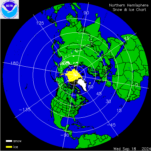
not sure how this compares to norms but here's the 30 day anime from usicecenter.gov
-
oceanwx was pointing out the other day that negative retention has become a kind of climate signal in and of itself. not sure what the feedback spectrum really is but it's easy to make plausible. the types of snow that are falling may be getting paradoxically lower in water - like it snows fluffier in cold air, to greater depths, but then a 'beef event' rains into the more gossamer snow pack and it's thus less resilient... etc. just spit-balling. one could almost holistically intuit that may be related to the same idea/observation in how globally, glaciers have been retreating, too - but either way, he was saying that the good old days ... a snow event or two, then a rain ... and the snow would absorb to refreeze and then the next snow layers ... etc. now more often even a deeper snow pack gets vanquished. i'm wondering if his office has really made that observation numeric, and in/of doing so ... what the temperatures in the low level are before and after the changes in the pack behavior. interesting -
-
probably getting more common
-
impressive diurnal ... 59 here, up from 30.
-
this reminds me of a personal muse i've been struggling with .. and that has to do with identifying the pacific warming as a heat "wave" waves by definition have a time dependency where they do not persist indefinitely. it's a wave ... it has some sort of precursor physical registry in the system, followed by a surge in whatever metric it is effecting, followed by a reduction in energy. thus, it is an ephemeral condition. it may just be a matter of semantic nitty picky shit ... or, maybe it reflects a fallacy in the understanding of what is going on with the oceanic sst/energy budget overall, within the ocean and outside where it is quasi coupled to the troposphere. hmmm like maybe this is not a 'wave' in that sense and should be thought of us the new basal state. in which case ...yeah, any telecon correlations that were previous to the new mode are rendered less than correlative. this true all over and everywhere. teleconnectors are correlating oddly. get use to it because the world may not be going back


