Typhoon Tip
-
Posts
44,524 -
Joined
-
Last visited
Content Type
Profiles
Blogs
Forums
American Weather
Media Demo
Store
Gallery
Everything posted by Typhoon Tip
-
Blowvember - and not named for wind potential
Typhoon Tip replied to Go Kart Mozart's topic in New England
fwiw - the ggem is east. just sayn' -
Blowvember - and not named for wind potential
Typhoon Tip replied to Go Kart Mozart's topic in New England
something similar happened in jan 1994 after that decent late dec to mid jan winter expression suffered a cutter and we soared to 62 f by 9pm ( 9 at dawn with snow grains earlier that day, i shit you nae ) with tree leaning white noise turbine gusts. there was steam rollin' off the snow banks. i saw the same thing then, too there's thaws. then there's fire-hose thaws - -
Blowvember - and not named for wind potential
Typhoon Tip replied to Go Kart Mozart's topic in New England
the gfs is doing something suggestive of the back ground forcing here. the -nao is western limb in the physical exertion - you can coherently see the +2 sd block over baffin island/vicinity up there... but that places the best telecon for coupled nadir between the del marva and ns/canada. meanwhile, the archembaultian amplitude *there's a concurrent +d(pna) going on* is coring out a deep dawg over pa. that can happen buut, it is in fact stressed - the better correlation is farther e with that. it may be seasonal/wave spacing, where this early in the season ... shorter distances causing more meridian flow so things close off early. interesting that the ggem is spot on the correlation tho - anyway, the gfs seems to respond to the back ground governing kinematics by attempting a new deepening se of cape code as that whole mess rotates through. the homage to the back ground forcing is more telling than the actual depiction throughout - in other words ... possibly signaling the direction of the correction vector -
Blowvember - and not named for wind potential
Typhoon Tip replied to Go Kart Mozart's topic in New England
i don't recall that one. huh - i was up at uml, probably heads down on how what was clearly going to be a historic front loader was going to effect us here in eastern sne, being why-for the distraction. but i do recall a steady diet of nickling threats kicking in early-ish in novie, then not seeing bear ground until the thaw of late jan, '96 -
Blowvember - and not named for wind potential
Typhoon Tip replied to Go Kart Mozart's topic in New England
yeah... it's trend continuance actually. there's been a tendency among all guidance ( for that matter ... ) for this pattern change-leading h.a. system to punch east of previous guidance. this one has a deep pva generate height response e of cape may nj at this point - furthest e yet. if it were not for the others also doing some of this east trend, i would roll eyes at the source but - again, lacking cold air... but that solution is like the canonical autumn page turning nor'easter of olden days. we used to depend on one block buster in autumn that was cold rain ... and one in late march that's wet/blue snow -
Blowvember - and not named for wind potential
Typhoon Tip replied to Go Kart Mozart's topic in New England
pretty fat recovery today too. big diurnal swing. 21 at 4 am and now 54 type rise at these home stations within a mile of me... but this spread matches kfit identically zip wind ...even the sloped sun of solar min is offering some nape affect out there. -
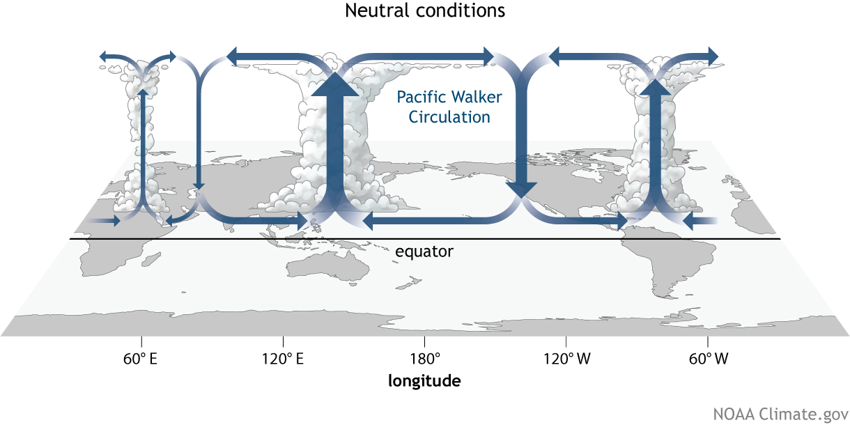
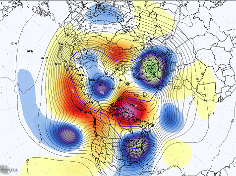
are we looking at mjo or we looking at a result of the walker circulation - for the gen reader, mjo doesn't present much more than 20 deg of lat n/s of the equator. it's the wave dispersion kinematics, spread out over the larger manifold beyond that latitude range, down stream ... which means by that physical definition, it is indirectly modulating as a forcer. it's also high subjected to constructive versus destructive wave interference in the rossby scale. that's why some mjo phases appear to correlate to pattern ( lag ), where other do not ..despite similar magnitudes. also, we bear in mind that the mjo can straddle one side of the equator more so than the other. some stronger wave/rmm prognostics could in fact be registered in the southern/northern side, respectively. there's a lot to consider there in the total machinery of the mjo ... and that look on those panels there appear to reflect more of the in situ walker signal.
-
Blowvember - and not named for wind potential
Typhoon Tip replied to Go Kart Mozart's topic in New England
this was 'fake cold' though. these last two days... even the day times held to 40 were kind of fake, too. "fake" semantics, that's probably a rubric for any situation were hot or cold over performs, relative to broader indicators/standard lens. you look at the charts, and the hydrostatic heights are barely below 550 dm thickness, which is the result of integrating moisture into the non-hydrostatic heights ...? never mind anyway, you don't typically get 20 f lows under 550 thickness. that's more likely to occur under 535 or less in 'standard synoptic' loading. also, keeping the high temperature just 40 f - granted the sun is now beans for heat contribution, still, we've seen 60 at this time of year/sun at 550 dm thickness. basically, the middle range of the troposphere is warm, the surface is cold ...relative to the former metrical layout. by a comparatively slivered range, too. so, we've been faked out. the end of the month isn't fake the way those indices modes are at that time. it's also nice to see the operational runs buying in a bit more. -
Blowvember - and not named for wind potential
Typhoon Tip replied to Go Kart Mozart's topic in New England
it's been a rather remarkably persistent signal, given both time of year, ...and recent decadal propensity for signals of any kind or context to not be persistently dependable. haha. seriously though, thanks giving week's pattern change. ..as an aside, this is just the way i personally get aroused ... nice and early front loading winter signals, hitting on the front side of the solar minimum entry. caveats are still this tendency to correct cold --> warmer, over time ... it's become a rather dependable aspect in all modeling for several years. still not abundantly sure why this occurs. i'd love to blame cc, but i don't really see how that would be the case mathematically - unless the moders really are fiddling with coefficients which according to literature ...there's nothing like that. i dunno. either way, we could verify the hemisphere and do so with less cold complexion. long way to go on that -
Blowvember - and not named for wind potential
Typhoon Tip replied to Go Kart Mozart's topic in New England
ooz euro and gfs oscillating toward the colder side of the a index range though for beyond the 21st ... i get it that we should go above for a bit in the foreground. however, this isn't like the earlier balloonings to +15+ c 850s over the top of a cc height dome this time. we're only recovering to half that - so it looks at this time. then we'll see if the pattern change is stable in future guidance. still a long ways, but it's impressive to see the weight of the euro and gfs ens means ( both ...) similar on this set up below, which is actually already corrected the 500 mb e enough that given a month and more antecedent cold we'd be talking about a major potential. as is, a slug of cold rain with wrap around hill top frosting. but that's a deep western limb -nao. notice also the -epo formulating over the alaskan sector - watch that for a cold load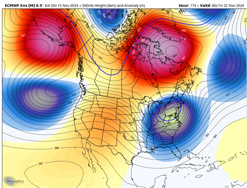
-
Blowvember - and not named for wind potential
Typhoon Tip replied to Go Kart Mozart's topic in New England
agreed .. i mentioned the same yesterday -
Blowvember - and not named for wind potential
Typhoon Tip replied to Go Kart Mozart's topic in New England
Both things are true though … west -NAO/ emerging +PNA arrives while it modulates both less - + , and less cold over time -
Blowvember - and not named for wind potential
Typhoon Tip replied to Go Kart Mozart's topic in New England
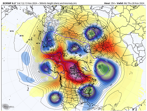
that’s a wholesale reversal in the anomaly distribution over eastern n/a between now and d9 in all three main player ensemble means. may and probably will prove transient but it is a coherent pattern change -
Blowvember - and not named for wind potential
Typhoon Tip replied to Go Kart Mozart's topic in New England
it’s something i’m paying attention too, ‘correction behaviors’ going from ext into mid ranges. cold enthusiasts may want to pay attention too … as we age into winter. this weekend’s script got flipped somewhere along the way … almost too subtle to have readily noticed. 3 or 4 days ago it was a cat paw windy showers around a retro low … now it’s 60s on Sunday with dslope dandies are we doing this in winter - are we doing this later this month for that matter. -
well ... for now, let's get the pattern to succeed in moving from the recent warm complexion, to a colder one. that much i'm higher confidence. however, it is still necessary to get the cold synopsis machinery working ... without it, 'what can go wrong' precedes the question - the only cons i see for now ( memo from the 'what can go wrong' department ) is that because the index prognostics are a bit more unstable in the transition seasons, that takes some confidence away. - additionally, in recent decade(s) there has been less stability with telecon predictions - probably owing to increased mid latitude, base-line wind velocities effecting the spatial and spatial-temporal ( both ) wave#s 2015 is really the last time a rossby signature set up and locked. it's sort of been that long... lots of roll-outs/ and pattern changes with shortened lease tendencies, etc.
-
kidding there ... but, the euro - i suspect - will not operate with any restraint in the extended, more so than the other guidance, this cold season. i've just too often in the past looked at that model on d9's and thought ... damn! if only this model went out 2 more days.
-
regardless of whatever ecmwf org statemens/faqs purport about the new dissemination of the 340 hour operational run, if it is anything other than a marketing ploy .. .utilizing the model's unique proclivity for destruction porn ... it's a lie!

-
this is a gfs ens mean from 12z ... if this were later on in dec certainly jan, we'd really be in business for some sort of correction event(s), as this is newly arriving off a pna mode shifting some 1.5 total sd, going negative to positive, while both the nao is western limbed, and pac up stream is in the AB phase -
-
i'm actually never wrong ... it's so weird - heh quite the fantastic telecon convergence in the d10 to 15 range ... granted, not the whole winter lol but, mm ...we're far enough into the season now etc etc to at least consider an early expression - sort of leaving that open-ended there on purpose haha. one cannot wisely say much in a trump-civility, because the inherent incivility of what that means will not operate within the confines objective constraint or reality, when it comes to interpretation anyway, this signal from about the 21st to the end of the month is actually promoted to a big one at this point. big for what tho. for now at least a pattern move from a warm-like one to colder once over central/E n/a is higher than normal probability - relative to this sort of time range.
-
Blowvember - and not named for wind potential
Typhoon Tip replied to Go Kart Mozart's topic in New England
this may sound like ego but it's not intended to push that shit. i disagree with there being no utility in long lead prognostic model depictions. particularly over time, if the user is aware of 'trends,' ...and for lack of better word, the tempo of recent nuances, they can 'see' the emergence of aspects that may not even be physically presented on any guidance at the time of the run/distance of the vision. this has some utility/usefulness when combined with the teleconnector prognositcs, the combination determines where the likeliness' are for corrections. some of us have started threads for activity anticipated some 2 weeks in advance in the past, and showed some decent skill. the secret is to keep the rhetoric leaning in trends, and don't attempt to be discrete. -
Blowvember - and not named for wind potential
Typhoon Tip replied to Go Kart Mozart's topic in New England
it's likely too long out in time for the operational versions to really avail, but the indices are still suggestive of a pro-seasonal expression during the week of thanks giving. that's the short version. -
Blowvember - and not named for wind potential
Typhoon Tip replied to Go Kart Mozart's topic in New England
mm that -nao low may retrograde over this weekend. some wet flakes to the northern els and chilly cap paw rain showers down here. euro's a bit warm tho -
Blowvember - and not named for wind potential
Typhoon Tip replied to Go Kart Mozart's topic in New England
nothing ( of course ) has verified yet but it seems the gfs is spending an aweful lot of electrons figuring ways to buckle the flow and create deep lows out there in the extended ranges -
Blowvember - and not named for wind potential
Typhoon Tip replied to Go Kart Mozart's topic in New England
heh.. whenever i see 'FWIW' and 'FXWX' ( john ) within a post or two of one another my dyslexia's on steroids -
Blowvember - and not named for wind potential
Typhoon Tip replied to Go Kart Mozart's topic in New England
first synoptic snow potential in 10 days + ... unless these indices are full of shit. but it's multi-sourced as a signal, one that was really seeded about 5 to 7 days ago and is now getting a -epo pulse added to its growth. was gonna elaborate but others have been discussing already -