

Typhoon Tip
-
Posts
44,524 -
Joined
-
Last visited
Content Type
Profiles
Blogs
Forums
American Weather
Media Demo
Store
Gallery
Everything posted by Typhoon Tip
-
Blowvember - and not named for wind potential
Typhoon Tip replied to Go Kart Mozart's topic in New England
there's a kind of anecdotal correlation for rather big events in the first 10 days of decs actually. more of those than there are great decs -
Gulf Stream to Shut Down this Century
Typhoon Tip replied to 40/70 Benchmark's topic in Climate Change
https://phys.org/news/2024-11-meltwater-greenland-arctic-weakening-ocean.html i find this fascinating, "...and about 20% weaker since the middle of the 20th century..." that's really an astonishingly fast rate in geologic terms. you know, with all these gitty-up observations, surpassing original conjecture, hypothesis, theory and model projections, ... it gets more suspicious to me that the main proponent in setting the time range for these changes as far out as they ever were, was really just the shear specter of a planet changing - it was/is just too big to get heads wrapped around it. thus, giving more time becomes something like a comfort instinct. ...just psychology getting in the way of sounder reasoning, perhaps - -
Blowvember - and not named for wind potential
Typhoon Tip replied to Go Kart Mozart's topic in New England
actually, that's rarer in the early chapters of pattern changing in "winter" ... we got the early feb oddity of -9f type 'continental tuck' last year,' but it's pulling out within 24 hours is a red flag for its equally unusual way in having that happen the way it did. more typically, the -epo cold load begins west, then ... spreads east. this chart above proooobably doesn't verify as is, from this range lol. right. but it does show a rather text book -epo dump, loading through the mt/dakotas route, and then compressing a thickness gradient through the ov. what we want after is the +pna to resurge...then, we have the cold in place for the h.a. recovery storm. -
Blowvember - and not named for wind potential
Typhoon Tip replied to Go Kart Mozart's topic in New England
not much dependency on one another if that's what you're getting at? dry doesn't beget dry in the colder climate months like it does in summer it's possible to be antecedent dry over an extended length of time, ...pattern change --> 30" of snow, and summarily go back to dry... -
Blowvember - and not named for wind potential
Typhoon Tip replied to Go Kart Mozart's topic in New England
impressive arctic outbreak in the ext 12z gfs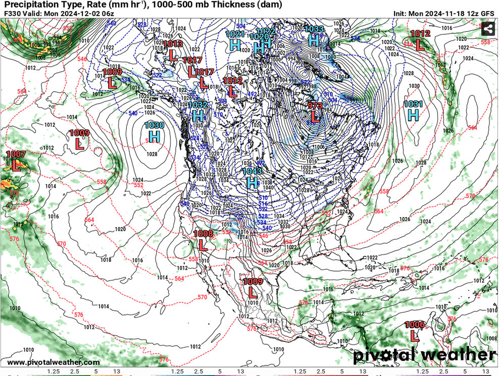
-
this is quite impressive ... https://phys.org/news/2024-11-scientists-plastics-soaps-detergents.html ...what irks me is that this is the 3rd or 4th article like this that i have come across spanning he last 10 years, and they seem to all have faded into oblivion. you never hear/read of it again. it's easy to get into paranoia and conspiracy theories involving big oil's nodal agencies but ... i in reality, humanity just doesn't enough appreciate, respect if even are aware ... what direction the real existential threats are coming from. this plastic thing is one of them. the climate is the other. either of these two WILL cross the thresholds of the irrecoverable, creating a new paradigm of environmental/ecological reality, one that probably does not include human beings - countless other species for that matter ... we're in in a fucking mass extinction event and this is empirically observable! yet, all these years of din and rage of humanity's ongoing travails ...? means nothing. it's like standing on a railroad track while the climate of the future is makes the iron vibrate under foot, yet arguing over the color shoes being warn to the engagement. it's all irrelevant when your dead. one of the greatest nature disasters ever to befall this world may in fact turn out to be the innovation of mankind.
-
Blowvember - and not named for wind potential
Typhoon Tip replied to Go Kart Mozart's topic in New England
heh... ya think ? at this point in history, a fool and his money will soon go their separate ways if/when it comes to purchasing much otherwise ... but snark aside, if there is going to be any bn out of the next 3 weeks, i don't believe dates prior to this weekend's pinwheel were slated to really be part of that. i was just looking at the average/seasonal and we're into the 40s already. it's seems above normal is all but precluded prior to next week. folks can get into pattern change failure.. sure. personally, i feel that high latitude blocking is at least transient during tg week. afterward, we'll see ... but the emerging extended wpo/epo both correcting negative ... sends an interestingly unstable look. -
Blowvember - and not named for wind potential
Typhoon Tip replied to Go Kart Mozart's topic in New England
seeing the -epo exertion on the thermal gradient. really cold in the 00z and 06z oper gfs sprawling canada by the 30th. ensuing frames keep it locked n of the border, with fast moving highly thickness compressed waves slicing along the ambient polar boundary - it's precarious. i wouldn't trust that handling not that there is a lot of continuity as we are heading into this new hemisphere ... yet, but as an aside, that reminds me of dec 2014. we were playing with dad's gun that month with cold to warm rain to cold flip flops, because we couldn't seem time confluence/a polar high just right. -
Blowvember - and not named for wind potential
Typhoon Tip replied to Go Kart Mozart's topic in New England
we're inside of 108 hours .. the euro will not likely be as bad as the populous falsity has popularized it to be. whether that means rain snow cats or dogs and for whom, aside ... it won't stray dramatically from the consensus at this range and in fact has a fair shot of being better in the nuances just like any of them -
Blowvember - and not named for wind potential
Typhoon Tip replied to Go Kart Mozart's topic in New England
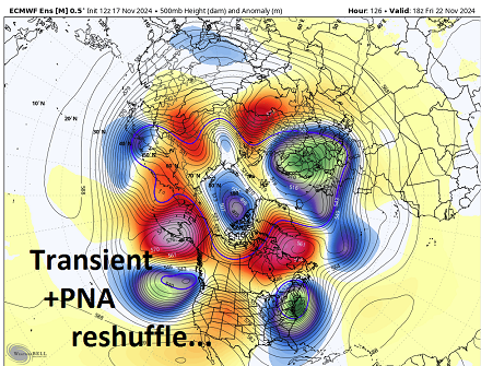
it's really more of a whole sale hemispheric reconstruction rather than just the nao switching mode. it's really complex... not to bog anyone down with tl;dr popsicle headaches, i'll try to make it just a sentence or two: the -nao is really the non-linear wave function transmitted via wave dispersion mechanics, down stream of the e pacific. we can see it now.. the nao is already negative and the -pna is ongoing - albeit about to fall apart bit longer version: ..SO, the ongoing -pna trough loading into the west has a waa consequence by l/w mechanics, which sends height anomalies over eastern Canada. one has to also not just look for this in black and white circumstances... it is nuanced... sometimes it isn't as coherent as we are just lucky enough to have as an example ( this abv is the 36 hour euro ens mean off the 12z run cycle) lol. oh man. it's true tho. just basically there is a change with an arriving +pna. it is coupling with vestigial -nao, which is once that block has materialized ... it then is a positive feedback --> synergy/constructive interference. it is why-for the changing of the guard... ending the dry era with a ( potential ) 2-3" event. this deep vortex here at 130 hrs (blw) is the result of all this the chances after that are interesting... the west pacific oscillation is not in any hurry to recover. in fact, i've been monitoring ...the extended ranges keep collapsing the index back negative for every day that appears over the outer model horizon. it's not hugely negative, but negative nonetheless. the 12z ens of the euro and gefs ... both show a low frequency -pna returning, but .. there is a low frequency -epo ( which is probably lag coupled with the wpo, because that is the nature progression). so the pacific is split between an over arcing cold signal, and a warm one tunneling underneath. the one underneath...that actually is the resonance signal for -nao. putting all this together, this is mm... moderately intriguing if a winter enthusiast going after this weekend's thing and through tgiving week. perhaps into the first while of december. as an after thought...this is the last 3-5 days of trend analysis. these large mass field indicators can also change. but for now ... etc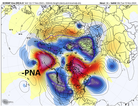
-
Blowvember - and not named for wind potential
Typhoon Tip replied to Go Kart Mozart's topic in New England
yup ...the upside-down low scenario. this is typically - I'd just caution a little - for models to do that complexion when dealing with marginality at the d5+ time range. it may be that we start to see some cyclonic domain cooling as the time approaches and the dynamic orientation ( physical feedbacks ...) become more coherent to the model processing. as an aside, whatever happens, this looks to me like a more classic autumn season turner nor'easter - not so much for cold +/-, but heralds in the 'storm season'. this was like this in the climate of old. it's only been recently that our autumns have been weird. anyway... nice to see that nostalgia there. i may thread this later ... the signal toward a nor'easter and potentially important one is gained a little here. i mentioned last week that the actual telecon geography for this sort of western limbed -nao, is actually between the del marva and s of ns, so the previous pa with low stacking over water town was not impossible, just not as well correlated. perhaps we are seeing the correction vector exerting here. i'm also a curious about a possible flat wave winter -like threat around the 27th give or take - so after this one. -
Blowvember - and not named for wind potential
Typhoon Tip replied to Go Kart Mozart's topic in New England
this goes for everyone … let’s let it go no one’s changing any minds or moving any needles. just agree to disagree and move on to something fun. -
Blowvember - and not named for wind potential
Typhoon Tip replied to Go Kart Mozart's topic in New England
i never said 74 million people. it was ‘Trump supporters’ in generic context which unfortunately … falsity pervades in greater quotient in that sphere of culture - yes it does. That may not be you - okay but you’re coming off as self-conscious I wouldn’t bother damning a wholesale number of population when a significant # of his voters were not really supporters of Trump - -
Blowvember - and not named for wind potential
Typhoon Tip replied to Go Kart Mozart's topic in New England
“ without taking a side”? You just took a side now the reason why the election turned out the way it did is because America’s been dumb down across successive generations and now lack objective sufficient filters Truth is not condescension just because you don’t like the sound of it -
Blowvember - and not named for wind potential
Typhoon Tip replied to Go Kart Mozart's topic in New England
and by the way ... i'm not attacking reps - sounds like it .. but i was trying to rib kevin. at any other time, i'll be glad to point the rhetoric weapon at dumb liberal democrats we're all assholes -
that's fun. the wpo and epo are +.2 correlated in dec and jan. it gets noisier in february, which is rather counter intuitive because that's about the time when the pattern is most seasonally coherent but whatever. .2 is a fairly high correlation coefficient, meaning that perhaps a 2 in 10 times, the wpo and epo are the same. some may read that and think, 'yeah, well then 8 in 10 times they're not' - but that's not right. the remaining 8 times are actually no skill. meaning the correlation is all over the place. the other problem with the correlations is that they are linear. that doesn't factor in time, that evil actuator of all events. the natural progress of events in the atmosphere is west --> east, barring any exceptionally rare hyper retrograding things. index domain spaces will tend to migrate east... in other words, there's a time lag that 'hides' some of the correlation of the wpo to the epo. that .2 is likely higher when time lags are applied. that's probably all i had to say haha anyway, this does leave room for -wpo/+epo but that's an unstable scalar state that is proooobably in a state of change whenever it is observed.
-
Blowvember - and not named for wind potential
Typhoon Tip replied to Go Kart Mozart's topic in New England
it was directed at kevin, because he attempted to spin what i said into a false impression/implication - and the twaddle that is out on social media that is consummately revealed by the trump supporter constituency as though it were fact, is preposterous dude. sorry, it is - as far as the other, america made a mistake - that can happen. and by the way... global warming is real, and it will cost humanity in increasing morality and destruction. it is so real in fact, that many present day natural disasters can be mathematically ( you are school teacher - you should understand the incontrovertible aspect of math proof ) connected to wildly changing climate. -
Blowvember - and not named for wind potential
Typhoon Tip replied to Go Kart Mozart's topic in New England
i know what you mean .. but just sayn' the "pattern" is highly likely to change. it may be transient and short lived... but, that is about as high on a statistical chi test for verification potential as is physically possible in modern technology with that west -nao block and deep trough running underneath. it's a matter of ironing out the details. see ... some times, you can be more certain about a mid or even extended range look. this thing we're looking at with the north american set up was sniffed out 12 days ago actually, by pure index interpretation alone - i know.. i wrote about it. and well, ... here we are, the operational runs emerged into that correlation. that behavior alone is typically a higher confidence predictor. etc... it's when we're flying along with nothing to look at and no leading indicators, and then all the sudden ... d9 has a bomb that lasts for 3 days of guidance - but uh uh uh ... d5 it disappears. that was never a higher confidence - ... there's all kinds of examples in either direction. the good fellas know which ones are which -
Blowvember - and not named for wind potential
Typhoon Tip replied to Go Kart Mozart's topic in New England
i think his intentions are buckin' for 'saving' his dystopian drought fantasy - not snow this time... lol -
Blowvember - and not named for wind potential
Typhoon Tip replied to Go Kart Mozart's topic in New England
it's been rarefying, sure tho. correction to what Kevin just said... I did not 'make a call' for a 'big nor'easter' - i made a generic implication interpretation of where those particular ensemble means appear to be trending. this is how the trump supporters create their fake realities and then believe in them. someone prevaricates an interpretation, ...then, their audience, being of cutting edge sharp intellectual pedigree rural red origin as they are ... they go ahead and 'analyze' what's said and shockingly, can't come up with any reason to question it. budda boom budda bing ... alternative reality is painted and the hapless contingent of morons are thusly guidance by an illusion -
Blowvember - and not named for wind potential
Typhoon Tip replied to Go Kart Mozart's topic in New England
fwiw .. .the 12z gefs and cmc ens means are significantly more deep with that closing southern component rex configuration next week ... this looks like it's trying to head toward a triple point nor'easter that abandons an old inland center type synoptic evolution.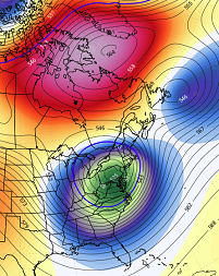
-
Blowvember - and not named for wind potential
Typhoon Tip replied to Go Kart Mozart's topic in New England
it'll be interesting watching these operational models engineer nothing out of a +pna/-nao loading pattern going forward. but, can't say this wasn't suspected. i spent more time than i should writing about the all but dependable cold loss in guidance, when moving patterns from the ext into mid range just the other day. also, those upside-down lows, with snow on the under belly in drilling west wind, and warm ( relatively so...) rains wrapped around the n side ( 120 hours) will tend to really go one way or the other. that's an unusual/rare verification as is. my guess in this case it goes to just rain. this is a -2, western limbed -nao with under running +pnap, after novie 15 ... where's the cold air. -
seems unlikely to me that a wpo/epo mean < 0 ...even if only between 0 and -1, would lend to that temperature distribution, at least along the np-lakes-ne belt but maybe some cc urine in the punch
-
Blowvember - and not named for wind potential
Typhoon Tip replied to Go Kart Mozart's topic in New England
that thing goes from ~ 990 mb to 960 mb in 10 hours lol challenges believability a little but we'll see -
Blowvember - and not named for wind potential
Typhoon Tip replied to Go Kart Mozart's topic in New England
yeah and who knows. but it's e of the others. i'd also note that the others are trending east - just not as aggressively. ex, the ggem was over michigan wednesday's 12z


