Typhoon Tip
-
Posts
44,523 -
Joined
-
Last visited
Content Type
Profiles
Blogs
Forums
American Weather
Media Demo
Store
Gallery
Everything posted by Typhoon Tip
-
Blowvember - and not named for wind potential
Typhoon Tip replied to Go Kart Mozart's topic in New England
on the road and not having been very well tuned in as of late ... but this 29th look hasn't changed since detection began over a week or whatever ago frankly. the cold was taken away in the guidance along the way. wah wah waahhh, as the sad trumpet goes. and while no trophy foisting yet, at this point a 29th occurrence is likely. probably a blend of the op runs and call it a day. as an aside, the gfs was likeliy too flat when this was mid ranged. again... not trophies yet, but the euro will likely win that debate. i'm not sure we're getting a euro 992 deepener passing e of bos per se ... but in principle, the gfs was indicating zip impact partly sunny with a flat wave 150 mi south of islip li over too many run cycles - that will likely turn out to be a bad mid range effort. -
December 2024 - Best look to an early December pattern in many a year!
Typhoon Tip replied to FXWX's topic in New England
it is. it actually fits the canonical load -release -load timing that more typically separates events in the atmosphere. sometimes the 2 in 72 hour thing can happen - 1997 - and so forth but that's rarer. i feel the 29th is a real event ...whether it develops in time for us or not, doesn't matter. meteorologically it counts as the succession. anyway, the dec 5-7 is legit -
Blowvember - and not named for wind potential
Typhoon Tip replied to Go Kart Mozart's topic in New England
it's the gfs what it's doing is acknowledging or arriving a very impressive pattern scaffolding ... but, negative or destructively interfering everything within the wholesale construct. if it gets it's way, the whole hemisphere will have changed from a warm base to a cold base, having nothing happen anywhere - ha, so it seems... i dunno. it's not really how things typically work, and the hurried frenzy where waves catch up and bully into each other mmm, yeah to some degree - the flow is quickening. it isn't without merit, but i feel the gfs does this thing where it's too willing, going too far whenever that memo's out there. -
Blowvember - and not named for wind potential
Typhoon Tip replied to Go Kart Mozart's topic in New England
this such a bum solution by the ggem at d6 ...
-
Blowvember - and not named for wind potential
Typhoon Tip replied to Go Kart Mozart's topic in New England
i dunno - i think a 'fair' subjective impressing ( ...good luck with that in the court of public opinion and social media's razor sharp equitability ...) is that what is presently modeled there is thrilling... i get it that is is not a stem-wound bomb potential ( as is ..) but that's not fair lol in part, we've not had this sort of pattern look, nor one that is entered by that kind of set up... since perhaps 2008! also, this is advancing in climatology, thi sort of look below, by several weeks or more. between the former and this aspect, this is an unusual total pattern loading and any potentials therefrom should also in the fairer sense draw some attention. -
December 2024 - Best look to an early December pattern in many a year!
Typhoon Tip replied to FXWX's topic in New England
what i find interesting about the outer <-- correction tendencies we've been observing ( i mentioned last week the wpo's been guilty of that as well fwiw - ) is that it seems the mjo is ( thankfully ) demonstrating early in the year ( thus necessarily reeducating people ) that it's not a pattern forcing mechanism, but is a reenforcer. the surrounding hemisphere has to be mechanically in sync it appears there are other motivating factors that are favoring a front loaded winter, and that they are suppresing/destructively interfering with the mjo in the right side of the rmm/marine continent. -
Blowvember - and not named for wind potential
Typhoon Tip replied to Go Kart Mozart's topic in New England
suggest 80% eps/geps blend weighting against gefs 20% - so not discarding the flatter appeal altogether, some inclusion in the latter is okay given to the quickening flow around the epo cold loading that's currently taking over continent. the gradient physically forces this latter aspect the flow's likely to speed up ... which unfortunately plays right into the gefs model system's subtle progressive bias that it inherited from previous versions - those were worse with that particular bias. i don' know about details with ptype and where. i'm just talking about averaging for a moderate fast moving cyclone. out of town. i shall miss whatever that entails -
Blowvember - and not named for wind potential
Typhoon Tip replied to Go Kart Mozart's topic in New England
the over all mass field handling between the date line and south of greenland is idiosyncratically different in the gfs. it's conserving a flatter rna signal, and that is in fact a constructive interference with the -nao phase states. so..it's just stronger with the nao because of it's flatter pna. the positive pna is technically unstable -aam load and usually doesn't last if it is in tandem with a -nao. the stable orientation is a +pna/+nao is the eventual rest state - this is technically more true in jf than nd, but it's vaguely there ...it comes down to in situ wave lengths. since we appear to be handling longer wlen like it were already in mid winter ...than the shoe fits. euro stronger pna = weaker nao = less suppression gef weaker pna = stronger nao = more suppression -
Blowvember - and not named for wind potential
Typhoon Tip replied to Go Kart Mozart's topic in New England
the nao is actually overbearing on this version ( gfs ) - if fact, that may be part of why it has been flatter than the other guidance since it started selling the bigger nao yesterday. may or not be so - but that's suppression -
Blowvember - and not named for wind potential
Typhoon Tip replied to Go Kart Mozart's topic in New England
something else i wanna add. it's low consideration but non-zero. there's a predecessor system around the 26/27th that scoots up as an eastern lake cutter, .. up the st l seaway. it's trended into an important system. one aspect of which ... it appears now capable ( as modeled ) of laying down a near-by cryosphere through ontario. that's actually a help in modulating low level cold supply. -
Blowvember - and not named for wind potential
Typhoon Tip replied to Go Kart Mozart's topic in New England
be an interesting eps coup for a week out over the gefs, because the latter's all but oblivious to next friday. i have to say, there's a new +delta emerging in the pna coming from the eps and geps ... it's gained more coherency over 3 consecutive cycles. this 12z run is a flat out mode change at this point. it should be noted, when +d(pna)'s take place during or post recent -epo's ... that is the typical prelude before cold loading along the mid latitude continent. in basic concept, that's establishing baroclinic/ambient polar boundary, thus enhancing storm genesis potential ... and dopamine gets injected.. heh. anyway, usually along the colorado - nyc axis. however, the gefs is much more neutral with the pna - even as of this 12z this morning's run it's not having it. not sure i trust that given the super synoptic ( and for lack of better word, 'intangible' ) trends. plus, the operational gfs actually came half way back more coherent with the 29th system over it's 00z run. something is there, and it's winter of profile... it should also be noted that the gfs had no problem carrying a 29th system through yesterday's runs. so it has a history of abetting the idea there. this is a sub-index scaled event. it's upside is probably limited to moderate in scope and scale. but, those are more apt to make us suffer some stochastic model handling. i want to start a thread but i'd like to see all three ens means at least trending in the gefs. it's the first real 'winter pattern' event trackable of the season and is worth of a separated discussion imo and confidence but in deference to being so early in the year ... heh -
Blowvember - and not named for wind potential
Typhoon Tip replied to Go Kart Mozart's topic in New England
12z nam backed things up a bit too - not sure if the graphical presentation gets that far west, but the fous for logan is an inch of cat paw white rain -
Blowvember - and not named for wind potential
Typhoon Tip replied to Go Kart Mozart's topic in New England
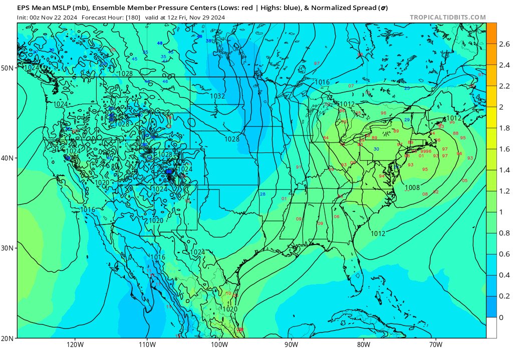
hmm... depends on what source one is using? this is the best ensemble presentation for that 29th thing to date, 00z eps mean. part of the problem with this event in guidance, other than that tiny little in "180" for time range ... is that it is sub-index scaled. the models will be more stochastic with small domain space events than they will with large mass field -directed majors. in other words, wait it out a couple of days is kind of obvious
-
Blowvember - and not named for wind potential
Typhoon Tip replied to Go Kart Mozart's topic in New England
yeah this system was inverted ( laterally ...) all along in the models. it's a diving -d(nao) under pinning low event, that is arriving on the heels of an antecedent warm pattern - consequentially, there was a defined dearth in cold leading the system environment. the cold is on the south side of the circulation because of that anomaly. and ... what east and/or northeast trajectories there were( you know all this ... ) ... gom buoys are reporting 50 to 52 ssts it's just is was a typical gloomy november deal -
Blowvember - and not named for wind potential
Typhoon Tip replied to Go Kart Mozart's topic in New England
didn't ask me but agreed ( bold ) it's marginal+ environment, but so far there are ptype rad returns west of the capital district, already, prior to best dynamics and also, albeit fractional ... it's a colder leaning quagmire during the night at this time of year. -
Blowvember - and not named for wind potential
Typhoon Tip replied to Go Kart Mozart's topic in New England
yup... the ski industry gets a nice start out of these next two weeks for that matter. probably be summit squalls regardless - -
Blowvember - and not named for wind potential
Typhoon Tip replied to Go Kart Mozart's topic in New England
sure is nice pattern eye candy ...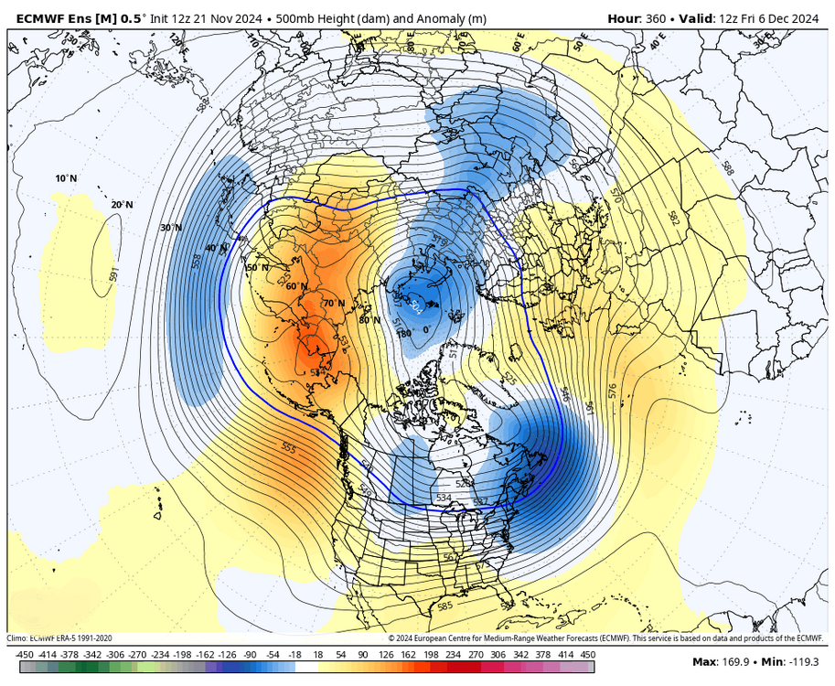
-
Blowvember - and not named for wind potential
Typhoon Tip replied to Go Kart Mozart's topic in New England
although ... the probability is going to be higher up by ray's place than kevin's due to where they are in relation to the system. -
Blowvember - and not named for wind potential
Typhoon Tip replied to Go Kart Mozart's topic in New England
i'm not speaking for Will but ... i don't think tomorrow night was really very high confidence to begin with. in my mind, it's possible - that's about it. it's up to the reader to be fair and honest about what that means. it's probably 36 to 39f through the region, with period light rain and cat paws in a stiffening n wind as that ccb clips the region ... but it's not long lasting either. it's probably just cloud and raw with wind in the afternoon (sat). this may perform better on mt wachusett and monadnock -
Blowvember - and not named for wind potential
Typhoon Tip replied to Go Kart Mozart's topic in New England
yeah... ironically, i recall just yesterday mentioning that without out or nominal polar high north of the region, we can still pull off an event by so-called 'needle threading' this is pretty much exactly how the 12z operational gfs gets at least a 34 f type of event through the region ( ~29th ). the 2nd's still also on the table btw - -
Blowvember - and not named for wind potential
Typhoon Tip replied to Go Kart Mozart's topic in New England
yeah.. it's too marginal to snort a line over. i'm just relaying what the grid has. it could be white rain just as well. but that's the coldest gridded thermal profile regarding that retrograding ccb i've seen to date. it's actually not even isothermal. 800 mb is -3c ... 900 is 0c and the bottom is +3c. shallow warmth and you can soak cotton balls at 37 .. 38 for non-accumulating ptype when the 900 and 800 average neg. fall rates can exceed melt rates at that chilly sfc reading -
Blowvember - and not named for wind potential
Typhoon Tip replied to Go Kart Mozart's topic in New England
that 12z nam fous grid is wet snow at Logan to almost 1” qpf sat morning -
Occasional Thoughts on Climate Change
Typhoon Tip replied to donsutherland1's topic in Climate Change
not sure if this should go into the pollution thread or here but ... great. now we've got a mechanism discovered that overlaps the plasticizing the environment, with factors that push climate change https://phys.org/news/2024-11-plastic-krill-ability-carbon-deep.html the two pillars of environmental concern, plastic and climate ...have largely been considered two separate problems - at least implicitly. but molecular polymer pollution interfering with the CO2 fixing capacity of the oceanic biota shows the two do have some possible feedback relationship it should be noted, ~33% of the CO2 produced by human activity since the IR has been eaten by the ocean. much of that capture is within mms of the surface. however, as the ssts warm the physics of this absorbing layer means less absorption. but there are other processes involved. -
Blowvember - and not named for wind potential
Typhoon Tip replied to Go Kart Mozart's topic in New England
i dunno - it sounded like you were letting the current presentation of -wpo/-epo pacific make you nervous about winter. i probably read in too deep. haha. but just sayn' i wouldn't do that. the problem i have, which just about abolishes all confidence in what djf turns out is that ... mm nothing we are seeing now ( according to my recollection ) is different from those snow shot across the bow events that preceded a lot of the piece shit winters that we've suffered over the last decade. that's a. b, i can come up with a hypothetical posit as to why ... it has to do with when the gradient of a warmer than normal mid and lower latitude hemisphere presses (seasonally) against the lowering heights above; that enhances the gradient and as recent seasons have shown, is offsetting the longer termed seasonal telecons - ex lending to episodic decoupling of the enso from the mid latitudes with increased frequency ... just one example. but also, the speediness of the hemisphere gets going in a month or so from now, and that kicks in another charm about gradient surplus: too much velocity. the intraseasonal telecons, like the wpo, epo, nao and pna, they're having trouble maintaining pattern biases at all ... stochastically vacillating between positive and negative modes ... this stuff is most likely going to happen again. -
Blowvember - and not named for wind potential
Typhoon Tip replied to Go Kart Mozart's topic in New England
you're eliding the point: yeah, but the processes involved are doing so when it is not typically a snow to begin with. it's alright. like i said ... you can penetrate the shroud of emotion-influenced attitude with reason, right or wrong. wrangling emotion cats .. .heh, i like that one. i just don't think anything about this system as being 'unfair' when the "evolution of the system and the processes involved" are actually ahead of the climate curve for this time of year. yeah, there's some positive 2-meter temp anomalies N-W of here. i'll give you guys that .. but in fairness, this system is over-achieving if anything when considering the total synoptic manifold and all parametrics