Typhoon Tip
-
Posts
44,523 -
Joined
-
Last visited
Content Type
Profiles
Blogs
Forums
American Weather
Media Demo
Store
Gallery
Everything posted by Typhoon Tip
-
i know...ha, cut and paste one of my gems and send that out to the pta while you're at it
-
oh.. right. no i meant that at a societal/general scope of this field, but may as well be everywhere heh. it's a problem in culture..."eschewing of intellect" in general. it kind of reminds me of "Idiocrasy," when they arrested him for being smart ass because he was smart. hahaha
-
my schadenfruede for tuggin on taint hairs
-
yet ...when some of us spend the time to really write detailed analysis from both surmise, as well as educated perspective base ... people don't read, rather ... make chide and/or make sarcastic barbs and general disrespect for the effort. basically, americans are turning into c*s
-
first and possibly last winter weather advisory of the season is out ...
-
December 2024 - Best look to an early December pattern in many a year!
Typhoon Tip replied to FXWX's topic in New England
zero z gfs was e with that idea of a new wave down the front fwiw - -
in fairness ...it's an unusual situation. it's bit of a beautiful nick of timing thing. if this ordeal hesitated for so much as a coffee break, we're +1c too warm all the way through the snow growth region of the sounding. but as is, in the guidance, the speed of the flow is actually helping something for a change. i mean this system overtakes the lower troposphere, which happens to be cold enough that there is a decently large drag coefficient and the system is overrunning it. otherwise obviously the sw flow, sfc to aloft, heh
-
December 2024 - Best look to an early December pattern in many a year!
Typhoon Tip replied to FXWX's topic in New England
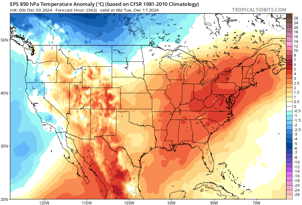
the eps is attempting to relearn ( ... or remind perhaps - ) us that we are in a new paradigm whence in the absence of a -epo or direct cold forcing, we surge warmer than normal and by an usual amount. i began noticing a kind of direct feed requirement for cold dependability .. about 12 years ago really. i recall posting about it several times spanning a few cold seasons thereafter - but have since declined the practice because no one ever really has responded with anything resembling an acknowledgement ( - no mystery there ). this paradigm began back then, where it and there are times when it is exemplifying - this 850 mb temperature anomaly by the 0z eps shows what a neutralized epo, ie, cold spigot closed, does to for us at mid latitude continent ... almost immediately. within a mere couple of days, blw ...granted, it is way out in the extended, but the predictability/confidence isn't the point. the physical processing of the model is, in principle, indicating the same phenomenon here where we seem to be in a state where we've lost the ability to sustain any averages -
-
December 2024 - Best look to an early December pattern in many a year!
Typhoon Tip replied to FXWX's topic in New England
noticed that ... weak but still substantive +pp layout along and n of the border from lake superior to mid ontario. close enough for llv insert ... then, southern push arrives for a snow to ice to (probably) cold rain. the ggem had something kinda like that on sunday morning's run - not exactly but similar result. but since then it's sliding any high pressure off to the east and unabated southerly wash ensues. meanwhile the gfs has been oscillating between too far west with the traffic, to not a chance too far west with traffic - pick which grinch -
haha ... snow on a sw wind? what could go wrong -
-
https://phys.org/news/2024-12-countdown-ice-free-arctic-timelines.html not a huge fan of the article's style of delivery and content presentation but ... the result is the result. i just find it something how the evidences of acceleration keep emerging. just 10 years ago the narrative was 'within the next 100 years' and yet again, here we see another example of how this climate change impact occurring sooner rather than later.
-
it does re af and presage to this thing down to 968 mbs as it passes east of down East Maine
-
December 2024 - Best look to an early December pattern in many a year!
Typhoon Tip replied to FXWX's topic in New England
-epo alaskan ridge same thing -
December 2024 - Best look to an early December pattern in many a year!
Typhoon Tip replied to FXWX's topic in New England
heh ...glad you put 'warm front' in quotes there. i mean, it's not like a warm front on the charts. it's just warmer heights south than 20 + years ago. even if only be 3 to 5 dm, that's significant enough generate more gradient induced, balanced basal flow rate around the hemisphere - and you are right, it's doing so at higher latitudes, where as a consequence to all of this, ...the southern jet is being 'robbed' so to speak ... i guess abandoned is more apropos. also, think of all this as tendency - it's not like there won't be a subtropical jet anymore. just talking about why the s/w mechanical smearing is become more and more prevalent. -
December 2024 - Best look to an early December pattern in many a year!
Typhoon Tip replied to FXWX's topic in New England
if/when said switch occurs ... the pdo does not force the pattern. it's a feedback from ocean-atmospheric coupling over a period of time. not you per se, but there's seems to be a misconception about that. once the pattern is there, there can be a secondary constructive sort of interference but it wasn't there first and it's overcome-able. having said that, the -pdo predominance may be an attribution result if that is the case, that's not lending a whole helluva lot of confidence that anything is going to push a +pdo mode - or if so, for very long -
December 2024 - Best look to an early December pattern in many a year!
Typhoon Tip replied to FXWX's topic in New England
just as an after thought you know, i am always leery of those facets when we enter favorable patterns. 'how are we going to end up paying taxes on this shit this time' with an eye rolling. we started getting charlie browned by them about .. 9 years ago, but at around that time, my memory was like, 'hey ..this has been happening for a lot longer now that i think about it' -
December 2024 - Best look to an early December pattern in many a year!
Typhoon Tip replied to FXWX's topic in New England
the colder deltas are in the east. the pacific injected s/w are riding along a very balanced medium, having traversed the entire pacific domain - which reaches to 55 N out there or whatever it is... s/w's enter the western continent, which by virtue of proximity to the pac is not appreciably different. however, by 100W the flow is ( mt torque ) instructed to tip s... the s/w goes s and that is intrinsically a nva as it rides down the negative slope of the l/w. compounding this with the fact that it is colder at 45 N over the continent, the flow is also more compressed: the former aspect has always been there; the latter compression has been growing as the ambient gradient between s canada and florida ( rough metric ) is more sloped. the whole luck thing for me... it's like going to a football game where a c+ team is trying to win against an a- team... luck can't cover the gap as well as if an a- team is playing an a- team. you could almost say that the a c+ team was lucky the score was ever close. -
December 2024 - Best look to an early December pattern in many a year!
Typhoon Tip replied to FXWX's topic in New England
those backward sloping vorticity fields in troughs are becoming more and more familiar since the late 1990s. what we're observing now in Brook's post above is evidence of the same aspect, and it is caused by a plague of speed saturation in the mid latitude, ambient flow. it's going on because the boreal heights of winters' onsets are compressing against what is ( most likely ) cc attributed elevated/residual heights at lower latitudes. this creates large gradient that is mechanically expressed as a faster geogstrophic wind. as an aside, a hint to this reality is that the glaam scalar values have been lower over the last ( in particular 10 to 20 years ). why? the sub-tropical jets are weakening, and the polar jets are becoming the stronger and more effective momentum transfer mechanisms. subtropical jets have a bigger radius variable in the momentum equations, ( radius x mass x velocity ), because lower latitudes are closer to the axis of earth's rotation. by mid latitudes, the angle is 45 deg and ... i think the above becomes trig function X mass X velocity ... which yields a lower glaam. now that heads are aching ... my work here is complete. that means that as the wind maxes are pushed N, the glaam goes mathematically down, because higher latitudes winds have a bigger axis of rotation angle. this is proof of what i have arguing over the last 15 years, when the quickening wind was being observed ... not just by me wrt to weather chart and model data, but by countless reports of jet flight historically low flight times along west to east routes, at mid and high latitudes over that same time span. i'd also argue that perturbation (system event) translation speeds have also been faster too, but etc.. s/w has a wind maximum of 110 kts ( say ...). in 1970, the ambient wind outside of the the s/w region is only 50 or so knots. that means that the s/w has a delta of 60 kts. in 2024, a 110 kt s/w wind max has a delta against an already elevated wind ambience of of 70 or 80 or so ... so the delta is 30. that's the same as saying 30 kts of wind mechanics are being absorbed; that sloping backward picture is the manifestation of that in illustration. i keep seeing that over and over again. a saga when the distant telecon spreads begin signaling a negative polar fields with favorable pnap across the east pac/continent ... then, it starts to show up in the operational runs ( usually with 300+ hour perfectly sculpted bombs )...but what happens is a lot of the absorption shit. what's also kind of interesting is that we also are increasing the intervals of these occurrence, because in general ... the pattern residences are shorter leased by proxy of the unstable resonance. so, the storm frequency is actually kind of the same, even though the above. -
how was +aam a pattern driver? i may also not be exposed to/understanding the discussion's roots ... just sayn' -aam is consistent with blocking patterns - referred at times to 'meridian flow' types. hint, -epo/-ao/-nao/+pna are meridian flow types +aam is consistent with less blocking patterns - referred at times to 'zonal flow' types. so i'm not seeing how a the last two weeks of -wpo/-epo, episodic -nao, with a +pna means a +aam is driving these to occur. first of all, the aam doesn't drive anything. that is scalar of the integral for angular momentum, which in it's simplest mathematical form, is provided by, radius X mass X velocity when the flow is flat/zonal/longitudinal, the radius term becomes very large, and the product of the above multiplication is thus also bigger --> +aam the forecast of the aam off model guidance is a forecast of a scalar value out in time. i get it that the aam is technically positive as a global integral - but all that means is that in the absence of recent -epo/-wpo and nao and so forth, the positive glaam would have just been even larger. there's a relativistic scoping that has to be considered.
-
December 2024 - Best look to an early December pattern in many a year!
Typhoon Tip replied to FXWX's topic in New England
17 coldest night so far this season -
December 2024 - Best look to an early December pattern in many a year!
Typhoon Tip replied to FXWX's topic in New England
This oughta tune up the posters good and proper
-
December 2024 - Best look to an early December pattern in many a year!
Typhoon Tip replied to FXWX's topic in New England
it's a specter that's looming. yup. this notion of getting through this interval with a huge underachievement relative to indicators - perhaps even nothing - has occurred to me. seeing a repeating behavior so far, but we'll see. just trying to bring some objectivity to the table. i'm noticing that the we have immediately in tandem with this, started this wave velocity problem again, the same as the last decade's worth of winters... maybe it's just the models, but it seems any attempt to bring cold into the 45th parallel immediately results in negative interference between s/w identity vs the basal gradient being too much. -
December 2024 - Best look to an early December pattern in many a year!
Typhoon Tip replied to FXWX's topic in New England
the mjo appears to have trouble propagating beyond phase 4. it is rather abruptly collapsing in the individual ens means in the rmm. while that is occurring, wpo is also tending to correct downward as the outer edge/emergent extended materializes over the temporal horizon. it's neutral out there around 300+hrs, but it's been failing to move closer in time along the mean curve... so long as all this is the case, current mjo outlook is in conflict with the wpo forcing, wrt the mid and upper latitudes ... the 'tendency' to -d(wpo), and the nearer turn -wpo phase state, together suggests the real hemispheric state for me however, those opposing forces are likely to enhance model variability in the mid month period, as far as determining the general pattern motif in that time. -
December 2024 - Best look to an early December pattern in many a year!
Typhoon Tip replied to FXWX's topic in New England
i saw this meme the other day that was eye rollingly funny... it was something like only in amerca do people trample over one another is a psychopathic rage of material hollowness a day after celebrating, in peace, a holiday to be Thankful for what they have. ...although, some of the households in here ... you know, you wonder if they are a delicious pressure cooker socio-dynamic functionality state, where time outs spent with social media serve as a release valve... lol -
December 2024 - Best look to an early December pattern in many a year!
Typhoon Tip replied to FXWX's topic in New England
probably i have a different approach to this material than most but when first glancing over these 500 mb frames what occurs to me first and immediately is alway 'what needs to be fixed' ...really the instant they pass into eye like i see immediately two problems with that above ( other than the 210 hr header sarcasm ) the first is, there is no ridging over the western atlantic basin there. that trough amplitude could increase by factors of 2 or 3 X's it scaffolded power ... if that flow stays flat leaving the continent/coast that is doomed to nada. the other aspect i hate is the gradient between 45 n vs 30 n, nearing 80 w ... it's too much. i've referred to this in the past as the miami rule - it's just a means to identify negative interference between the large, vs smaller scales. i look at heights over mia prior to any diving wave out of western canada. if they are > 582 dm, and/or the base geostrophic wind ( the flags along the isopleths) are over 35 kts there is negative interference between the large vs smaller scales. another way to sense this interference is occurring, despite all that depth over michigan, the delta(pna) is not that impressive anywhere around the circumvallate of that trough.